Author Topic: NSW & S Qld Severe Storms: 11-14 September 2008  (Read 44366 times)

0 Members and 1 Guest are viewing this topic.

Offline Michael Thompson

  • Multi-vortex F1
  • *
  • Posts: 57
RE: NSW & S Qld Severe Storms: 11-14 September 2008
« Reply #15 on: 14 September 2008, 02:59:08 AM »
As Jimmy eluded to moisture is going to be a major challenge for southern NSW - Wagga, Young, Albury, etc today (13th).

I made a post on that other forum last night where I looked at GFS's very optimistic dewpoints for 16Z yesterday ( Friday ) where they suggested 10-12C, the real observations were almost exactly half that. Transfer that to today and that 1500-2000 CAPE gets severely lacerated. However we are hoping for some magic, perhaps the better moisture further north to have been advected southwards overnight and through the day. We have some storms firing off in northern NSW this morning.

On a side note I was in a busy training course in Brisbane yesterday, but at least the plane returning to Sydney got to take off under a very weak storm (0.5 out of 10 type ). Nothing much to be seen however.

Offline Michael Bath

  • storm chaser
  • Administrator
  • Wedge tornado F5
  • *
  • Posts: 1,602
  • Gender: Male
    • Australian Severe Weather
RE: NSW & S Qld Severe Storms: 11-14 September 2008
« Reply #16 on: 14 September 2008, 04:14:25 AM »
I was able to watch from Ballina the beautiful isolated storm come up from the Grafton area. Storm longevity, radar and visible structure when the storm got closer indicate it was supercellular for part of its five hour track. The report of golf ball sized hail in the Grafton and Ulmarra areas helps support that.

---> Grafton radar loop

The storm was putting out a lot of anvil crawler lightning for the 3 hours I was watching. There were not many visible CGs until it was closer and collapsing.

Click photos for larger view.

(5.40pm)


A cane burn gave some interesting colours (6.20pm)


Some interesting structure.

(7.00pm)


(7.15pm)


(7.30pm)


The lightning later on was very impressive - these are not cropped. Light rain meant I was unable to stay alongside the river when the lightning was right over Ballina.

(7.50pm)


(8.10pm)


(8.30pm)


regards, Michael
« Last Edit: 16 September 2008, 04:04:52 AM by Michael Bath »
Location: Mcleans Ridges, NSW Northern Rivers
Australian Severe Weather:   http://australiasevereweather.com/
Lightning Photography:   http://www.lightningphotography.com/
Early Warning Network: http://www.ewn.com.au
Contact: Michael Bath

Offline Mike

  • Australian Severe Weather Moderators
  • Wedge tornado F5
  • *
  • Posts: 1,348
  • Gender: Male
  • Dry season here...boring!
    • http://StormscapesDarwin.com
RE: NSW & S Qld Severe Storms: 11-14 September 2008
« Reply #17 on: 14 September 2008, 06:30:58 AM »
Wonderful photos MB and thanks for posting them.  You say that the Cg activity did not come until the dying stages of the storm?  Was this a last burst of released energy from this storm as the strikes look very healthy!
Darwin, Northern Territory.
StormscapesDarwin.com
Lightning Research 2010/14

Offline Shaun Galman

  • Stove pipe F3
  • *
  • Posts: 441
  • Gender: Male
    • ridgelightning.com
RE: NSW & S Qld Severe Storms: 11-14 September 2008
« Reply #18 on: 14 September 2008, 07:31:00 AM »
Hi all,
Great shots by all here! Nice lightning and sunset anvil photos MB!

Rodney W & Michael B: Any indicators to possible rotation in that unreal looking storm near Lismore? Could it have been a small SC? The structure is absolutely amazing!

Good to finally see a few nicely formed storms here and there over a few days (still with a day or so's continuity I hope)

I spotted one large and very nice looking storm cell between Walgett and Collarenerbri on Thursday evening at 5pm with nice structure, forward shearing anvil etc. I had a prior engagement so I couldn't get home to grab my camera in time? Russ was watching it also but said it soon died off and dissipated to nothing.

Missed out here yesterday with the quite active storm line between Cobar and Tibooburra dying off early on and I saw no trace of anything approaching as I watched and waited right up to 11pm. Clear sky's all the way. Earlier on in the day I thought something may have happened but the W-NW winds were gusting very strongly and I suspected that if we'd had a cell form here or close by, it would have shot past fairly rapidly!

As for today, temps are up towards 30ºc, currently stable at 29.6ºc but we are under a steady layer of what seems to be stratus and nimbostratus cloud with a frontal break to the west showing widespread cumulus towers on the rise. Humidity is only 54% but feels more like 70%? It has risen from 31% at 11am which is ok! Only some light W-NW winds blowing. I'd like to see a 20 or 30% raise in humidity but that may be wishing a little too much lol. Looks like there might be something at the back of this stratus cover in the way of upper level moisture that's feeding the strong towers?

I'll definitely keep an eye on things out here over the coming hours! :D

If any of you head on out to chase today, take care!
Shauno
« Last Edit: 14 September 2008, 07:36:30 AM by Shaun Galman »
Chasing Region: Lightning Ridge. N.S.W.
Website: www.ridgelightning.com

Offline enak_12

  • Elephant Trunk F2
  • *
  • Posts: 153
  • Gender: Male
RE: NSW & S Qld Severe Storms: 11-14 September 2008
« Reply #19 on: 14 September 2008, 07:38:22 AM »
Ah wondered about that storm in Grafton I nearly chased it but didn't because I went out last night, I would of got home to late. I went to Heritage Park late in the afternoon (between Coffs and Woolgoolga) to photograph Kangaroos that gather there and watched the back of that storm.


Offline David C

  • Global Moderator
  • Barrel tornado F4
  • *
  • Posts: 643
  • Gender: Male
    • Thunderbolt Tours Storm Chasing Adventures
RE: NSW & S Qld Severe Storms: 11-14 September 2008
« Reply #20 on: 14 September 2008, 10:01:37 AM »
Gee those forecast soundings show basically dry adiabatic lapse rates up to around 600, a shallow subsidence inversion above that with extreme drying of the airmass, and then free rein for parcels all the way up to 250. Yep, moisture deprivation is the problem with 9-12 dps across the target area, but surely something has to take off! C'MON as Lleyton Hewitt would say !
Storm Chaser,
Thunderbolt Tours - USA & Australia Storm Chase Tours
www.thunderbolttours.com

Offline Shaun Galman

  • Stove pipe F3
  • *
  • Posts: 441
  • Gender: Male
    • ridgelightning.com
RE: NSW & S Qld Severe Storms: 11-14 September 2008
« Reply #21 on: 14 September 2008, 01:33:09 PM »
Upper Western. Storm Update 11th September. 2008
Hi guys,
There has been some decent storms fire up close to us (South of Walgett) these weren't small either! Two that really took off around 4pm, in a series of three heading towards Coonamble, were easily visible from here. These were at least 100k's distant. I wasn't without my doubts as to seeing a few smaller pulse storms pop up but no luck out here as yet?

There is an amazing storm line on the LT and radar between Albury, Bourke and on up towards Thargomindah (QLD). I can easily see the flashing out west from my back yard coming from the storms between here and Bourke. It's just teasing us now I think? So close yet so far! lol ;)

Winds are pushing from the N-NE currently. This is a little puzzling as the storms are pushing South fast! Makes it hard to predict whether a cell will turn or not? Still warm enough to drive the convection however little there may be. This is different from the last few nights where temps have dropped rapidly to the low 20's-high teens around 7pm. 

If the storms eventually arrive, no matter how late, Russ and I will be awaiting eagerly :)
Kind regards,
Shauno
Chasing Region: Lightning Ridge. N.S.W.
Website: www.ridgelightning.com

Offline Mike

  • Australian Severe Weather Moderators
  • Wedge tornado F5
  • *
  • Posts: 1,348
  • Gender: Male
  • Dry season here...boring!
    • http://StormscapesDarwin.com
RE: NSW & S Qld Severe Storms: 11-14 September 2008
« Reply #22 on: 14 September 2008, 02:19:17 PM »
Solid structure in that photo.  Nice wedging aloft also.  Would also like to know if the storm was supercellular.  From the photos and radar it was a monster.
Darwin, Northern Territory.
StormscapesDarwin.com
Lightning Research 2010/14

Offline Michael Bath

  • storm chaser
  • Administrator
  • Wedge tornado F5
  • *
  • Posts: 1,602
  • Gender: Male
    • Australian Severe Weather
RE: NSW & S Qld Severe Storms: 11-14 September 2008
« Reply #23 on: 15 September 2008, 03:35:22 AM »
Re: the Grafton to Ballina storm 12th Sep

There are hook echoes on a number of frames, particularly 0800 to 0840UTC and possibly 0920UTC too. No doubt the hook was also present as the storm passed near and over the Grafton radar site.  There's evidence of outflow on the 0850UTC frame but the storm regrouped for a while after that.

The storm was fairly compact - perhaps into the LP end of the supercell spectrum?  A number of photos show interesting structure though I was not able to see earlier base features. You can match up the times of my photos (previous post) to the radar.

(7.12pm - cropped and enhanced)


So yes, the storm would have been a supercell.

Mike - the best lightning did happen as the storm had weakened from its supercell stage - match the radar to my photo times (UTC+10). The photo above is close to the time of the third radar image below.


« Last Edit: 15 September 2008, 03:40:44 AM by Michael Bath »
Location: Mcleans Ridges, NSW Northern Rivers
Australian Severe Weather:   http://australiasevereweather.com/
Lightning Photography:   http://www.lightningphotography.com/
Early Warning Network: http://www.ewn.com.au
Contact: Michael Bath

Offline Shaun Galman

  • Stove pipe F3
  • *
  • Posts: 441
  • Gender: Male
    • ridgelightning.com
RE: NSW & S Qld Severe Storms: 11-14 September 2008
« Reply #24 on: 15 September 2008, 04:27:11 AM »
Hi all,

Thanks for the info on that (now confirmed) SC storm Michael! What a great little storm to start the season for you guys! :D

I found myself up and ready to go at 2:30am with the first rumblings of thunder from 2 small cells that approached town from the N-NE. I had my suspicions that they would not be long lived given the moon was lighting things up nicely around the cells so I could see the rain cores and their pretty rapid movements easily. I watched the first CG's come down towards the Eastern edge of the first cell (seemed about 25k's away from a rough count with the thunder reaction) but as I reached for my camera the rain set in, and quite heavy for a brief period, and so I had no choice but to sit it out on my front verandah. By the time the rain core moved across us (taking all of 10mins or so) the CG's had all but stopped leaving only the odd distant crawler now and again. Not good enough to risk having my camera soaked for lol. I should say that I was only on foot so if I had to get to shelter in a hurry for any rain it would have taken too long?
The second cell skirted town just a bit further East and left no hope of getting positioned somewhere fast enough with no obstructed view to photograph it? All in all I was a little disappointed not to get shots but I very much enjoyed the brief light show none-the-less :)

We had another larger storm roll in this morning at 8am but skirted town to the West and was/is still heading South currently. Activity was sparse at around 30sec. intervals but the CG were strong for these low-ish temps. Rain has hampered any attempt at photography again with light showers still persisting now. There was no structure attached to this storm just a dark blue-ish grey appearance that doesn't make real good lightning photos! ;)

Russ is now apparently writing a letter of complaint to the BoM asking for better storms. lol!

Cheers and take care,
Shauno
Chasing Region: Lightning Ridge. N.S.W.
Website: www.ridgelightning.com

Offline Jimmy Deguara

  • Australian and Tornado Alley storm chaser
  • Administrator
  • Wedge tornado F5
  • *
  • Posts: 2,218
  • Gender: Male
  • Storm Chaser since 1993, Tornado Alley 2001
    • Australia Severe Weather
RE: NSW & S Qld Severe Storms: 11-14 September 2008
« Reply #25 on: 15 September 2008, 04:42:59 AM »
Hi guys,

Yesterday saw only higher based storms develop in struggling moisture. The drive was pretty good with the three of us Imelda Kim and I remaining near Forbes and enjoying the surroundings. The storm to the north was getting closer so we head towards Parkes but I abandoned that chase as the storm began to weaken. I tell you what though, the country has never been so green and it will be great if this could last into the late spring and summer months - make for some nice photographs once we get a few supercells over the plains.

Today I must say looks quite interesting with rapid destabilisation over the central NSW area by late this afternoon. There is a break in the cloud bands and if heating could occur, the observed shear could make for interesting storms by 4pm. They will be moving rapidly though. Lightning already increasing on the tracker across the Central West and South West Sloped.

Regards,

Jimmy Deguara
-------------------------------------
Australian Severe Weather
www.australiasevereweather.com

Australian Thunderbolt Tours
www.thunderbolttours.com

Phone  0408 020468  (International :  61  2  408 020468)

Offline Michael Bath

  • storm chaser
  • Administrator
  • Wedge tornado F5
  • *
  • Posts: 1,602
  • Gender: Male
    • Australian Severe Weather
RE: NSW & S Qld Severe Storms: 11-14 September 2008
« Reply #26 on: 15 September 2008, 05:12:03 AM »
No luck there Shauno - even with the effort of being up at that time of night - no wonder Russ is putting in a complaint :)

Wagga sounding has 65 knots NW at 850 !  - gees, no wonder the cells are flying across the state.  STW for damaging winds - no surprise there.
Location: Mcleans Ridges, NSW Northern Rivers
Australian Severe Weather:   http://australiasevereweather.com/
Lightning Photography:   http://www.lightningphotography.com/
Early Warning Network: http://www.ewn.com.au
Contact: Michael Bath

Offline Michael Bath

  • storm chaser
  • Administrator
  • Wedge tornado F5
  • *
  • Posts: 1,602
  • Gender: Male
    • Australian Severe Weather
RE: NSW & S Qld Severe Storms: 11-14 September 2008
« Reply #27 on: 15 September 2008, 11:51:19 AM »
Reports of large hail from Parkes before 4pm - these VIS/lightning tracker images show some large cells in the Parkes to Peak Hill area and west of there. A number of cells are showing strong echoes even at the limit of Sydney radar.


« Last Edit: 17 September 2008, 01:11:03 AM by Michael Bath »
Location: Mcleans Ridges, NSW Northern Rivers
Australian Severe Weather:   http://australiasevereweather.com/
Lightning Photography:   http://www.lightningphotography.com/
Early Warning Network: http://www.ewn.com.au
Contact: Michael Bath

Offline pingtang

  • Multi-vortex F1
  • *
  • Posts: 70
  • Gender: Male
    • Southcoastweather
RE: NSW & S Qld Severe Storms: 11-14 September 2008
« Reply #28 on: 15 September 2008, 12:25:28 PM »
Heres a report on yesterdays chase.

Me and a friend(lightning chaser) left for Wagga early yesterday morning. We probrably left 3hrs too early but it made the trip alot less rushed. A major accident on the Hume HWY between Yass and Jugiong forced southbound traffic on a 50km detoir via Harden and eventually back to Jugiong. We decided to continue onto Temora rather than going to Wagga. While filling up in Harden(1030am) a warm breeze was blowing from the north with hardly a cloud in the sky. Dewpoints were hovering in the 9-10c range. We continued onto Temora and grabbed some food and some scratchies. We then found some shade 10kms south of Temora with a great view to the NW and played some cricket(1230pm). Weak moisture starved towers were evident to the far NW towards Griffith but never did anything. Some weak static was evident on the AM radio,but I figured this was up towards Cobar.

Eventually(330pm) it started clouding over with some weak showers developing overhead.At this stage,the static on AM was picking up big time but we didnt know where this was. At about this time I got a call from FeralWx,he mentioned about a cell near Moss Vale so we figired this was the reason for the static.

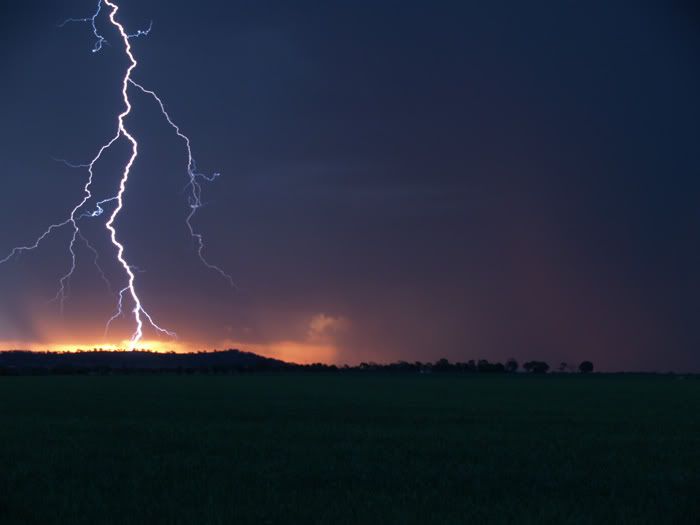
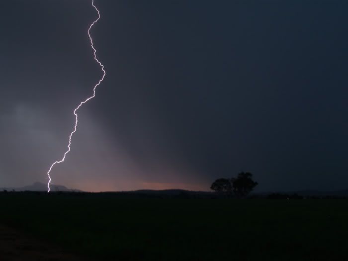
The sky to the north had a horrible look to it,but there was definate potential to the West and South so we headed for Wagga. While driving through Junee a weak line was becoming evident to the west towards Griffith.Feral wx called again and said the line had a decent amount of lightning in it. We finially saw our first CG to the south just before reaching Wagga. We drove through Wagga and continued southwards finding a nice spot 10kms south of town with good views to the E/SE and also to the W/NW. Weak cells to the southeast contained some nice CGs but these were becoming distant. A new line to the west quickly captured our interest just on sunset when it threw out a nice CG. This line was very weak and highbased containing no structure but the CGs were quite active and of good quality.As the line moved in some quality staccatos started touching 5kms away in front of the setting sun. I got a few of these on video while my friend was lucky enough to get a photo.

Unfortunately rain kicked in ahead of the line forcing us into the car. Some great CGs were available after dark but they became very embedded making photography next to impossible. Nevertheless I managed to capture alot of quality CGs on video so im happy about that. The lightning continued for a good hour before dieing out somewhat. We left Wagga at about 8pm and headed for home. All in all,a decent chase.


Offline James

  • Elephant Trunk F2
  • *
  • Posts: 149
  • Gender: Male
    • Sydney Storm Chasers
RE: NSW & S Qld Severe Storms: 11-14 September 2008
« Reply #29 on: 15 September 2008, 01:06:50 PM »
A few pics as the line passed through Sydney from Middle Dural. One very nice bolt from the anvil hit a good 10 or so kms from the updraft upon my arrival.


Last one taken after the storm passed from Galston.