Author Topic: QLD & NSW Severe Storms (incl Blackwater hail & Brisbane flash flooding): 19-21 Nov 2008  (Read 49633 times)

0 Members and 1 Guest are viewing this topic.

Offline Steven

  • Global Moderator
  • Stove pipe F3
  • *
  • Posts: 410
  • Gender: Male
OK last night we missed out on the deluge but there was heavy rain up until 2am, accompanied by deep booms of thunder, and very little wind to report surprisingly. I know it is a different story for Brisbane and surrounding areas that have been inundated, especially around damaged areas of The Gap.

So today I did my own re-plotting for West Brisbane at 30/18 and got a fairly nice -5.29 LI and 2541 CAPE, but that's not it. Sheer is looking surprisingly good today compared to yesterday at 700MB & 500MB so we should all be definitely in for some action later on I think. Only just started mastering Skew-T's lol.

jamesdumar

  • Guest
I am seeing strong cumulus development here in Inverell and it is muggy.

Offline David Brodrick

  • Elephant Trunk F2
  • *
  • Posts: 130
    • Oz Forecast
Storm Report - Narrabri, NSW

Low based cells moving east just dropped about 15mm in a few minutes, blacking out my webcam, and many strong wind gusts were recorded by local weather stations, including 100km/h at Narrabri Airport and 92km/h at my place.

If you're interested:
http://narrabriweather.net/

Now back to work if I can calm my excitement..
Cheers,
  Dave

Offline Shaun Galman

  • Stove pipe F3
  • *
  • Posts: 441
  • Gender: Male
    • ridgelightning.com
Hi Shauno,

I am glad you got to it - nice flanking line. Did it seem to be a right mover? One would not have been surprised that storms were lightning active today.

Regards,

Jimmy Deguara
Hi Jimmy, et al.
I didn't seem to be a right mover that I noticed? It was a steady split of the main larger storm at 3pm over town that this smaller, more severe cell impacted into. It was small but clocking a fair pace with a weak 'scud' shelf that disappeared once we started taking the pics. It went in a basic straight line from the West, over the norther edge of town and out towards the East which is the direction the photos were taken.

I did however notice a good left mover on radar that was heading SE from 40-50k's South of Bourke and made a sharp left hand move back up towards Carinda around 6pm-ish. It looked well formed and it was isolated by itself.

Thanks for the kind words MB! Luckily the core of that cell missed town only a few hundred metres as it passed us! I don't know what the totals were from it unfortunately? But we've received a further 5mm today with two cells passing across town. I only picked up 2 good CG but the rain would have made photography impossible. We are under mostly blue sky again but there seems to be Cu building out West again. Temps are 28.7Âșc currently.

*did anyone else come across that left mover just inland of Coffs Harbour yesterday afternoon on radar?
Regards,
Shauno 
Chasing Region: Lightning Ridge. N.S.W.
Website: www.ridgelightning.com

Offline James

  • Elephant Trunk F2
  • *
  • Posts: 149
  • Gender: Male
    • Sydney Storm Chasers
A nice cell moved across NW Sydney around lunchtime today. A few photos as it moved across from Richmond. First one is the mammatus under the anvil of the earlier Central Coast storm.


Offline nmoir

  • Elephant Trunk F2
  • *
  • Posts: 200
  • Gender: Male
  • "busting chases since 1999"
    • Oculi.com.au
these two cells just ahead of the squall line look to hit brisbane , they already look nasty.  doppler picking up 90kpm + winds from the line

« Last Edit: 21 November 2008, 01:06:22 PM by nmoir »
Nick Moir
Photographer
The Sydney Morning Herald
and www.oculi.com.au

Offline Carlos E

  • Elephant Trunk F2
  • *
  • Posts: 135
  • Gender: Male
BoM's weather radar server is understandably quite slow at the moment. Must be very high traffic.

I hope it doesn't affect the same areas again.

My apologies if this post comes out twice, dunno where my other post went.

Offline David Brodrick

  • Elephant Trunk F2
  • *
  • Posts: 130
    • Oz Forecast
Narrabri, NSW Storm Report

Hey folks. We finished up with the 100km/h wind gust, substantial hail (to 1cm size) and up to 32mm of rain being measured near Narrabri. Our new webcam captured a pretty slick timelapse movie of the storms today. I've just cobbled a quick report together on our Narrabri Weather site, any feedback welcomed!

http://narrabriweather.net/events/20081120.html

Best wishes,
  Dave

Offline Shaun Galman

  • Stove pipe F3
  • *
  • Posts: 441
  • Gender: Male
    • ridgelightning.com
Hi David B.
Wow that time lapse is amazing! It's good to watch directions of each cell and how they interact / dissipate etc. I thought seeing the anvils looming overhead then an onslaught was particularly interesting to watch :D

Looks like Brisbane is about to receive more troubles on the radar currently. I hope they are prepared for any outcome tonight.

Take care,
Shauno
Chasing Region: Lightning Ridge. N.S.W.
Website: www.ridgelightning.com

Offline Harley Pearman

  • Barrel tornado F4
  • *
  • Posts: 584
South east Queensland storms - A probable 1 in 80 year event:

Auburn Council's Drainage and Development Engineer and myself had a look at this rainfall event for south east Queensland focussing on two weather stations being Amberley and Gatton. The figures are:-

Amberley:

At 7 pm 19/11/2008 there was 0.2 mm of rain in the rain gauge. The main burst starts at 7.30 pm.
By 2.30 am 20/11/2008, there was 156.6 mm in the rain gauge and 157 mm by 3 am. That is effectively 157 mm in 7 hours. It works out at 22.4 mm per hour. The Drainage Engineer has calculated this out between a 1 in 80 and 1 in 100 year event.

Gatton:

It starts at 5 pm 19/11/2008 with 3.2 mm in the rain gauge and or 0 mm at 4 pm. By 2 am 20/11/2008, 170.4 mm was in the rain gauge. It was over by 2 am. It works out 21.3 mm per hour for 8 hours or 23.88 mm per hour for 7 hours (Excluding the 3.2 mm that fell between 4 and 5 pm). Again it falls within the rank of a 1 in 80 to 1 in 100 year event.

It is regarded as a major rain event when calculating rainfall intensities, stormwater runoff and flooding impacts.

One gauge had 243 mm in it being the top fall.

Blacktown:

Overnight a substantial storm passed across the Sydney area. In Blacktown it produced sustained winds and a short lived blackout (Probably due to tree branches falling across nearby power lines where I live) and sustained rainfalls for around 35 minutes. Additionally a sizeable tree in Mantaka Street was knocked down as well. It produced 32 mm of rain where I live.

I saw one cloud to ground lightning strike and the remainder of the lightning was within cloud giving a great strobing effect but no opportunities for taking photographs.

Harley Pearman

Offline Richary

  • Barrel tornado F4
  • *
  • Posts: 680
  • Gender: Male
Same here at Rydalmere Harley. Lots of stuff in the clouds but saw no bolts. We got 30mm from last night's storm.

As for Brisbane, had an email from the ex that the storm were she was (Fortitude Valley just east of the CBD) got hail and a bit of overflowing gutters again this afternoon as the storm came through.

Offline Rodney Wallbridge

  • Multi-vortex F1
  • *
  • Posts: 71
  • Gender: Male
    • Red Bubble
Gyday all here is a story of a Guster that formed near Lismore this arvo. Julian from Brisbane just got here in time for pics as well!!! The line of storms certainly formed nicely with moisture on tap and with cape to load up on. Afterwards this cell had moved to the east the Anvil cloud  exhibited some awesome anvil crawlers before dark. A weaker cell to the west gave a breif show of Stacatto Cg's


Offline Rodney Wallbridge

  • Multi-vortex F1
  • *
  • Posts: 71
  • Gender: Male
    • Red Bubble
Here's two more. This weaker cell held some promise for a while....a few stacatto's  thunder rolling around the valley was pleasant too :)


Jeff Brislane

  • Guest
It seems yesterday there was significant hail from a Storm that hit Blackall in Central Queensland. The report on the ABC newsite states many homes and cars with wind smashed as well as a caravan park that has been re-aranged by the hail and strong winds. It'll be interesting to see the hail size from this strom as it sounds like it's probably around the 8cm mark.

Regards Jeff.

Offline Michael Thompson

  • Multi-vortex F1
  • *
  • Posts: 57
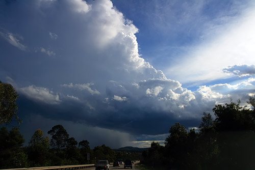
Chased yesterday (20th) to the Hunter Valley with Feral. I have rarely seen a cap (or lack of ) break so quickly. At one stage on the expressway near Moonie Moonie the view north and northwest was cloudless blue, yet by the time we made Raymond Terrace it was convective popcorn. Unfortunately this limited what had potential for a nasty day.

We pushed west of Maitland to Branxton where we encountered a severe cell.  The outflow winds would have pushed towards 100kph, enough that a tripod could not stand. (my have some film later)


The shear was very quick and literally within 2-3 mins of the above images we were overtaken by the wind and hail. The very first stones we saw looked close to golfball, but were very isolated. I think Feral's X Trail got smacked on the side by one of these (we forgot to look for a ding). As hail increased the size dropped to 2-3cm.

Very short lived and we headed back to Maitland.
The situation did not look that great, it was now quite cool and all CAPE had been mopped up and the storms were heading NE. We knew from the early cells that we had no chance of running down the line, so we headed home.

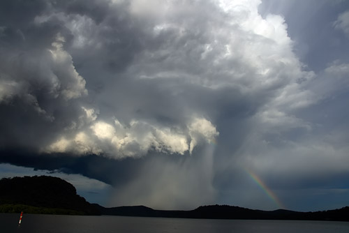
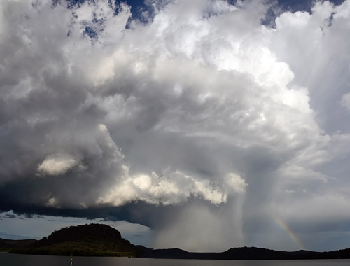
However we did score a very photogenic an isolated cell near the Hawkwsbury River, even a possible mid level shear funnel.