Author Topic: Cold and Snow VIC / NSW / SE QLD: 27-29 July 2008  (Read 26847 times)

0 Members and 1 Guest are viewing this topic.

Offline Michael Bath

  • storm chaser
  • Administrator
  • Wedge tornado F5
  • *
  • Posts: 1,602
  • Gender: Male
    • Australian Severe Weather
Cold and Snow VIC / NSW / SE QLD: 27-29 July 2008
« on: 27 July 2008, 09:51:26 AM »
A substantial slow moving upper trough and cold pool will affect most of NSW and S QLD Sunday into Monday. Models have been in fairly close agreement with temps and RH fairly positive for non-alpine snowfalls. It's looking good for both the Central and Northern tablelands. A low is expected to form off the North Coast by Tuesday.

An interesting aspect of this system is that it's not associated with a cold front and should take its time crossing the state. This should equate to decent accumulations of snow in some areas.


Location: Mcleans Ridges, NSW Northern Rivers
Australian Severe Weather:   http://australiasevereweather.com/
Lightning Photography:   http://www.lightningphotography.com/
Early Warning Network: http://www.ewn.com.au
Contact: Michael Bath

Offline Jimmy Deguara

  • Australian and Tornado Alley storm chaser
  • Administrator
  • Wedge tornado F5
  • *
  • Posts: 2,218
  • Gender: Male
  • Storm Chaser since 1993, Tornado Alley 2001
    • Australia Severe Weather
RE: Cold and Snow VIC / NSW / SE QLD: 27-29 July 2008
« Reply #1 on: 27 July 2008, 10:34:04 AM »
Michael,

You beat me to it as I ran out of time last night.

I was surprised about the consistency of the models with such a deep cold layer of southerly air surging (or pivoted) around the back of the deep low - certainly an unusual or should I say uncommon occurrence. Given there should be some moisture based on the various models, we should see snow over the Central Tablelands as Michael already suggested.

If it is sufficient snow, I will likely take Imelda and Kimberly and my sister to see their first snow. For those out venturing, be careful of road closures.

Regards,

Jimmy Deguara
-------------------------------------
Australian Severe Weather
www.australiasevereweather.com

Australian Thunderbolt Tours
www.thunderbolttours.com

Phone  0408 020468  (International :  61  2  408 020468)

Offline Michael Bath

  • storm chaser
  • Administrator
  • Wedge tornado F5
  • *
  • Posts: 1,602
  • Gender: Male
    • Australian Severe Weather
RE: Cold and Snow VIC / NSW / SE QLD: 27-29 July 2008
« Reply #2 on: 28 July 2008, 03:58:45 AM »
I wonder if some of the Northern Tablelands sites have some frozen precipitation already ?  Armidale recorded 0.2mm at 8pm with the temp on 1.5. Glen Innes this morning also recorded 0.2mm with the temp below zero.

Looking very encouraging for snowfalls over wide parts of the Northern Tablelands starting late tonight or early am Monday.

I'm going to head up with my son David early Monday.
Location: Mcleans Ridges, NSW Northern Rivers
Australian Severe Weather:   http://australiasevereweather.com/
Lightning Photography:   http://www.lightningphotography.com/
Early Warning Network: http://www.ewn.com.au
Contact: Michael Bath

Offline Richary

  • Barrel tornado F4
  • *
  • Posts: 680
  • Gender: Male
RE: Cold and Snow VIC / NSW / SE QLD: 27-29 July 2008
« Reply #3 on: 28 July 2008, 10:32:22 AM »
Someone has just rung Vega 95.3 to report snow at Chatswood and Lindfield, with people stopping to photo the white Pacific Highway.

The rain I experienced up near Pennant Hills about 30 minutes was just falling as rain, not sleet however. A few rumbles of thunder from the storm as it moved passed to my east.

Offline Shaun Galman

  • Stove pipe F3
  • *
  • Posts: 441
  • Gender: Male
    • ridgelightning.com
RE: Cold and Snow VIC / NSW / SE QLD: 27-29 July 2008
« Reply #4 on: 28 July 2008, 11:04:05 AM »
Hi all,
Feels as if it's partially across us (upper western) already so I'm expecting rather low temps tomorrow (Monday the 28th)! We've had cool winds and partial showers on and off all day which has been a bit of a downer as I have Rodney Wallbridge staying here with me for the expo and the stalls shut early today due to the downturn in the weather? Rodney tells me that he is looking forward to getting into the thick of the snow on his return trip tomorrow! I wish I could tag along to witness it first hand... ahh well one of these days lol?

Cheers guys, rug up and stay warm! :D
Shauno
Chasing Region: Lightning Ridge. N.S.W.
Website: www.ridgelightning.com

Offline Jimmy Deguara

  • Australian and Tornado Alley storm chaser
  • Administrator
  • Wedge tornado F5
  • *
  • Posts: 2,218
  • Gender: Male
  • Storm Chaser since 1993, Tornado Alley 2001
    • Australia Severe Weather
RE: Cold and Snow VIC / NSW / SE QLD: 27-29 July 2008
« Reply #5 on: 28 July 2008, 03:50:53 PM »
Hi,

My Fiance Imelda, her daughter Kimberly, my sister and I went snow chasing today. We linked with some moderate snow falling near Edith just before Oberon and it was just beginning to accumulate. At that stage, Shooters Hill had nothing when we got to it but 2km south or so, there was a very similar light cover perhaps slightly more than Edith. It did not snow at all throughout the afternoon until late afternoon when rime fell heavily.

We met up with Jimmy (not me) and his partner who is on this forum at Shooters Hill. We had a little chat and then as we were about to leave, it began to snow. At this point Jimmy and his partner left though I hope they got to see the snow falling. It created a light cover but we decided after about 20 minutes to mkae tracks home.

For Imelda and Kimberly, this is the first time to see snow and they enjoyed it!

Regards,

Jimmy Deguara
-------------------------------------
Australian Severe Weather
www.australiasevereweather.com

Australian Thunderbolt Tours
www.thunderbolttours.com

Phone  0408 020468  (International :  61  2  408 020468)

Offline Jason(pato)

  • Elephant Trunk F2
  • *
  • Posts: 136
  • Gender: Male
RE: Cold and Snow VIC / NSW / SE QLD: 27-29 July 2008
« Reply #6 on: 29 July 2008, 02:50:20 PM »
Hi Everyone,

Well just got back from the trip up to Guyra with the family. We managed to clock up 740km for the trip, which can seem like an eternity when you've got a 2 and 4 yr old to entertain.

Anyway to the report. We arrived in the Guyra district around 6pm on Sunday evening. On the approach to Guyra (about 10kms out) we were greeted to some flurries of sago snow which quickly gave way to flakes nearer to town. It stopped just as quick as it had started. We got to the motel checked in and then ducked outside as it had begun snowing again. This time the flakes were much larger and in no time had begun to accumulate on the ground to a depth of around a 1cm. This continued on and off for the next three hours, with some flakes looking like they were at least 50c piece in diameter. Had an eventual accumulation of 3-4cm. I didn't venture too far from the motel as I still had family duties to attend to. During the snowfall I was keeping MB and Roddy informed of what was going on (MB made the decision to travel up that night). At around 9pm the snow stopped, which unfortunately gave way to rain/sleet that diminished the cover somewhat by morning.

Today held the promise of more snow, but we had to wait until around midday for it to happen. Met up with MB ,Bryan, the two Daves and another chaser (whose name i didn't catch). My kids were driving my wife and I crazy so we decided to head into Armidale for a drive. Didn't see much in the way of snow acuumulated but it was near midday so the sun would have burnt what was left off. Whilst in Armidale we experienced freezing rain/sago, so we made the mad dash back to Guyra to hopefully catch something more substantial. Arriving back in Guyra we were greeted once again with sago snow which continued on and off for the next couple of hrs. Got a report of some snow falling at Ben Lomond from MB at around 2pm so decided to call it a weekend and head home via there. There was a nice cover on the ground through Ben Lomond so it was a pleasant way to end our trip.
Well what can I say? After initially thinking this event would be marginal it turned out to be a nice little event indeed. What was most memorable about this chase was seeing the looks of wonder and hearing the excitement from my family, as this was the first time any of them had experienced snow.
Here is a few photos in and around Guyra from the two days. Enjoy

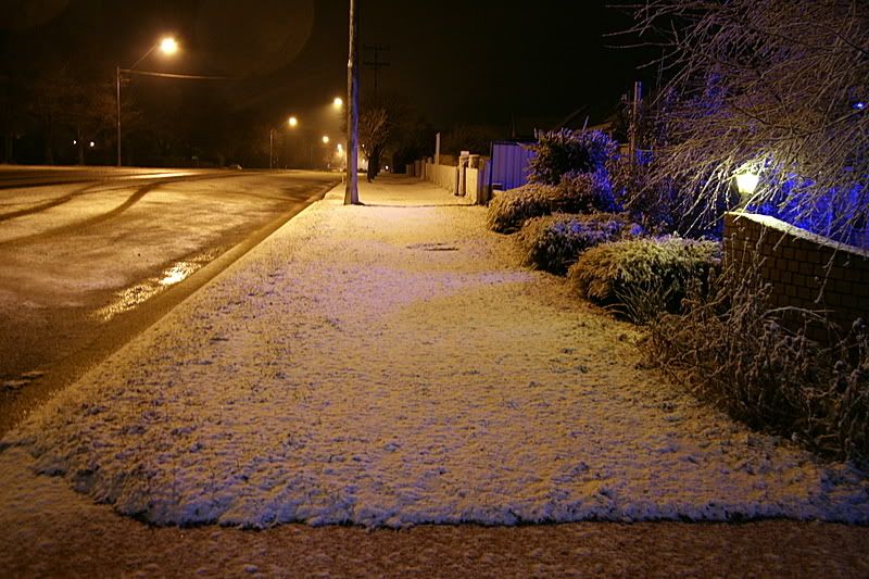
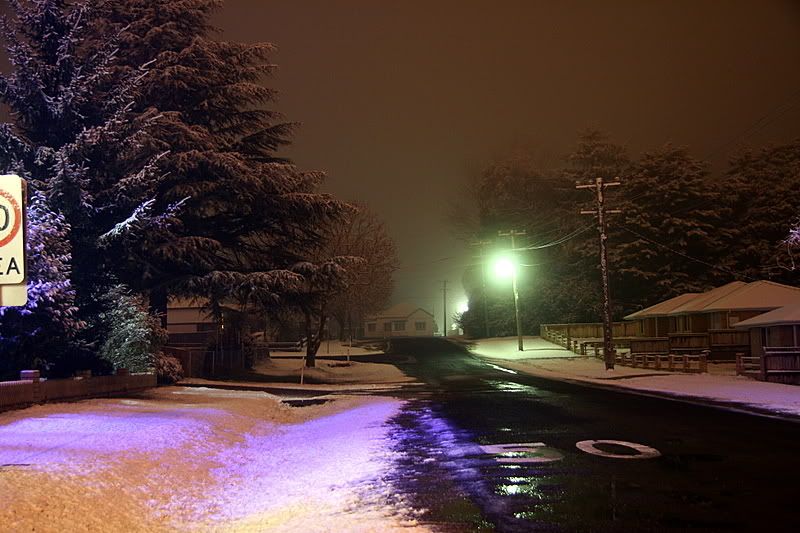
The first three pics are from around Guyra on Sunday night


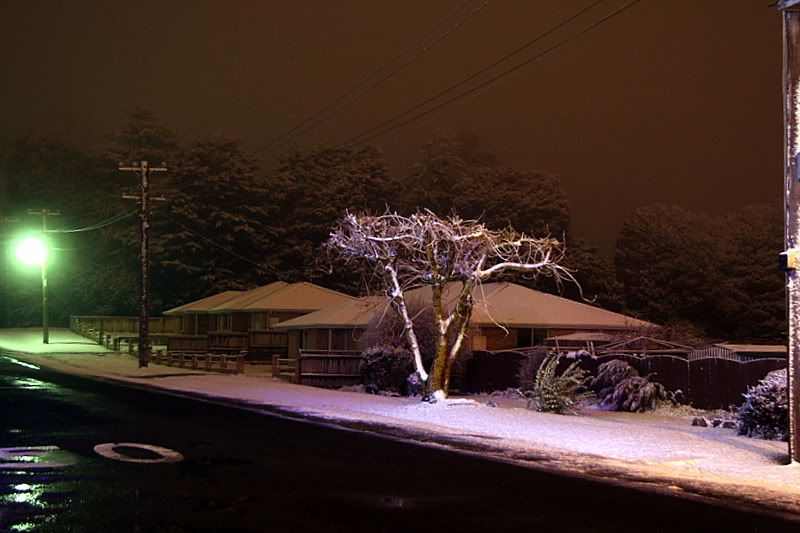
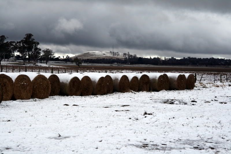
The next pic is taken outside Guyra early this morning


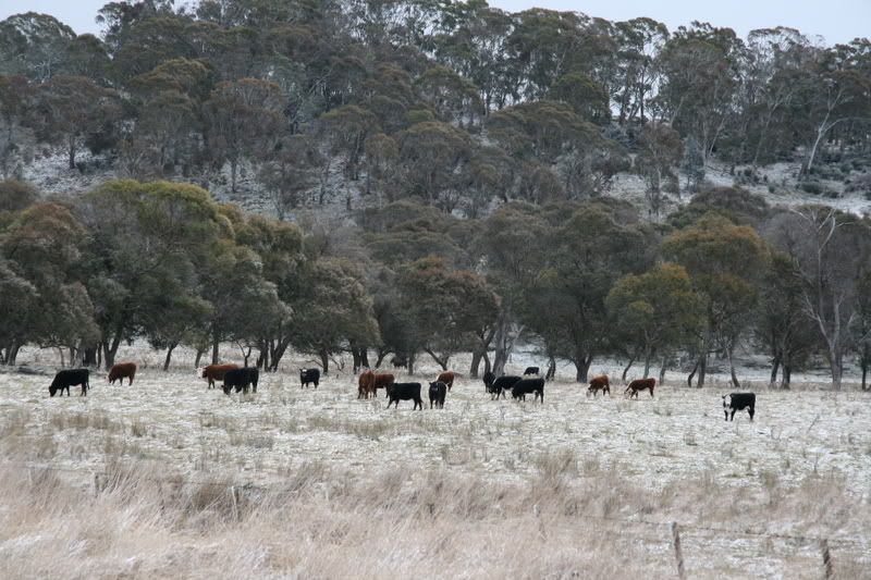
This pic taken near Ben Lomond on our way home


South Lismore, Northern Rivers NSW.....Supercells are us!!

Offline Harley Pearman

  • Barrel tornado F4
  • *
  • Posts: 584
RE: Cold and Snow VIC / NSW / SE QLD: 27-29 July 2008
« Reply #7 on: 29 July 2008, 02:51:40 PM »
I have been watching weather models and it is most unusual to see the current setup pattern.

This system has penetrated into south eastern Queensland. I have read a report that snowfalls have occurred along the ranges in the SE of this state. Snow has been reported at a place called Eukey where snow started to fall around 10 am and snow may have fallen near Stanthorpe.

Snow has also been reported at Guyra (I read 3 cm from Weatherzone). I also read another report that snow fell at Omeo (Altitude around 700 metres) in Victoria.

The snow level appears to have fallen to around 900 metres and flurries or sleet fell in the Katoomba region 27/7/08.

It was colder in Sydney 28/7/08 where maximum temperatures were in the 13 to 14 C range although 12 C was the maximum at Terrey Hills. This is well below average.

In addition, showers spread across the metropolitan area and from 9 am to 8 pm rainfalls varied from 19 mm at Little Bay (Highest), 16 mm at Ingleburn, 12 mm at Sydney and Terrey Hills with lighter falls in the greater west such as 5 mm in Blacktown where I live.

Harley Pearman

Offline Richary

  • Barrel tornado F4
  • *
  • Posts: 680
  • Gender: Male
RE: Cold and Snow VIC / NSW / SE QLD: 27-29 July 2008
« Reply #8 on: 29 July 2008, 04:03:17 PM »
Harley

Without having studied weather models the map on the TV tonight looked very unusual. Two high pressure systems (one over SW Qld - though latest bureau maps not showing it, and the other south of Tas). Then two lows one off Brisbane and the other towards southern NZ allowing a nice funnelling of Arctic air up this way. Instead of the normal pattern of just two systems causing airflow these seem to be reinforcing the airflow up from a long way south.

I thought the clouds yesterday looked different from normal ones and loaded with very cold air and water. Just the appearance of them even during the day before the storm event started.

Offline Michael Bath

  • storm chaser
  • Administrator
  • Wedge tornado F5
  • *
  • Posts: 1,602
  • Gender: Male
    • Australian Severe Weather
Re: Cold and Snow VIC / NSW / SE QLD: 27-29 July 2008
« Reply #9 on: 30 July 2008, 08:18:45 AM »
Some photos from the Guyra and Ben Lomond areas Sunday 28th July 2008.  Took my 11 year old son David on his first snow chase - he had a wonderful time :) We arrived at Guyra about 12.45am after receiving the snow first reports from Pato. The original intention was to leave the Lismore area pre-dawn but I'm glad we left during the evening.

I was surprised that scattered snow showers did not occur and it ended up being fairly isolated. The models certainly reduced the precipitation accumulation amounts on the day. If you look at the Moree sounding you can see the setup was very impressive temp-wise. At first glance the moisture appears ok but it's actually a bit dry through the lower parts for lots of showers to occur. 

Compare with 8th June 2007 when a lot of snow fell.

Morning at Guyra. Some drizzle after the early evening snow reduced the cover.


The next few are on Ben Lomond hill. The snow cover was topped with hail pellets - graupel I think it is ?


These two pics were a bit after 2pm when a couple of heavy snow showers passed through. Taken along Inn Road east of Ben Lomond.


Really enjoyed the chase meeting up with Pato and his family, David Smith and co, and Bryan. And we also intercepted with Rodney and family for the drive back to Lismore from Glen Innes.

regards, Michael

Location: Mcleans Ridges, NSW Northern Rivers
Australian Severe Weather:   http://australiasevereweather.com/
Lightning Photography:   http://www.lightningphotography.com/
Early Warning Network: http://www.ewn.com.au
Contact: Michael Bath

Offline Shaun Galman

  • Stove pipe F3
  • *
  • Posts: 441
  • Gender: Male
    • ridgelightning.com
Re: Cold and Snow VIC / NSW / SE QLD: 27-29 July 2008
« Reply #10 on: 31 July 2008, 06:28:48 AM »
Hi guys,
Some real nice images here! It's a good old "christmas in July" Northern NSW winter wonderland lol! If only our Dec. christmas times were like this, it would be great! :D

We received a further 4mm in a shower on Sunday the 27th at around 10:30pm, accompanied by a sudden brief hail shower with only small stones around 3mm in size.

Take care all!
Shauno 
Chasing Region: Lightning Ridge. N.S.W.
Website: www.ridgelightning.com

Offline David Brodrick

  • Elephant Trunk F2
  • *
  • Posts: 130
    • Oz Forecast
Re: Cold and Snow VIC / NSW / SE QLD: 27-29 July 2008
« Reply #11 on: 31 July 2008, 04:24:30 PM »
Snow, Mt Kaputar, 27th July 2008

It's good to see the snow reports from the tablelands and nice to hear all the stories above of people seeing snow for the first time.

On Sunday afternoon there was some light to moderate flurries of powdery snow on Mt Kaputar that resulted in 10-15mm of snow accumulating on the ground. Large snow flakes were interspersed with graupel falls (or is it called rime?) like what Michael describes above.

Here's our full report:
http://narrabriweather.net/events/Snow2008.html

Here's a couple of photos:
(Ed to reduce size of photos - didn't help much)
« Last Edit: 31 July 2008, 04:47:48 PM by David Brodrick »

Offline Michael Bath

  • storm chaser
  • Administrator
  • Wedge tornado F5
  • *
  • Posts: 1,602
  • Gender: Male
    • Australian Severe Weather
Re: Cold and Snow VIC / NSW / SE QLD: 27-29 July 2008
« Reply #12 on: 02 August 2008, 01:24:35 AM »
Hi David - thanks for posting that report - always interesting to read and see what happened at Mt Kaputar.

I'm pretty sure it is graupel - rime is the build up of ice on objects - like in the 3rd photo I posted above.

Some extreme man-made examples :)

http://www.australiasevereweather.com/forum/index.php?topic=869.0

Michael
Location: Mcleans Ridges, NSW Northern Rivers
Australian Severe Weather:   http://australiasevereweather.com/
Lightning Photography:   http://www.lightningphotography.com/
Early Warning Network: http://www.ewn.com.au
Contact: Michael Bath

Offline Jimmy Deguara

  • Australian and Tornado Alley storm chaser
  • Administrator
  • Wedge tornado F5
  • *
  • Posts: 2,218
  • Gender: Male
  • Storm Chaser since 1993, Tornado Alley 2001
    • Australia Severe Weather
Re: Cold and Snow VIC / NSW / SE QLD: 27-29 July 2008
« Reply #13 on: 03 August 2008, 03:35:48 AM »
Here are a couple of the pictures from the snow chase at Shooters Hill last Sunday:

-------------------------------------
Australian Severe Weather
www.australiasevereweather.com

Australian Thunderbolt Tours
www.thunderbolttours.com

Phone  0408 020468  (International :  61  2  408 020468)