Author Topic: NSW storms 14 - 21st November 2007  (Read 52914 times)

0 Members and 2 Guests are viewing this topic.

David Carroll

  • Guest
Re: NSW storms 14 - 21st November 2007
« Reply #15 on: 18 November 2007, 09:42:17 AM »
Bathurst just had a good 10 - 15 min hail storm.  Hail stones nothing bigger than 1.5 cm. Enough to cover lawn though.  PLenty of lightning and heavy rain , high winds with this storm. Seems to be heading N now.. followed by another storm from the South near Oberon now.  Spoke to Jimmy, he is near Mittagong now, gave him an update of the storms near him. If he is lucky should see a storm from the south if it doesnt die off. 

« Last Edit: 24 November 2007, 11:40:56 AM by David C »

Offline scottme

  • Multi-vortex F1
  • *
  • Posts: 37
  • Gender: Male
Re: NSW storms 14 - 21st November 2007
« Reply #16 on: 18 November 2007, 11:40:41 AM »
So why do the coastal areas seem to be showing such an aversion to the weather affecting the inland areas? Is it that the atmosphere is so neutrally stable that the elevated surface heating is the main driving factor in this system?
« Last Edit: 24 November 2007, 11:41:17 AM by David C »

Offline Jimmy Deguara

  • Australian and Tornado Alley storm chaser
  • Administrator
  • Wedge tornado F5
  • *
  • Posts: 2,218
  • Gender: Male
  • Storm Chaser since 1993, Tornado Alley 2001
    • Australia Severe Weather
Re: NSW storms 14 - 21st November 2007
« Reply #17 on: 18 November 2007, 02:32:50 PM »
Hi,

17th November 2007 chase report

I targeted and chased the Marulan area. Initially, the activity was centered near Berrima. A nice little storm developed and back built northwest out of my reach to confirm precipitation type. So I backtracked from near the Hilltop 'jungle' to Mittagong. I noted towers were developing along the southern flank of the storm. Half decent updrafts developed in the region. This activity had developed with slightly lower bases in response to the moisture boundary.

I headed down towards Marulan in response to the retreating activity. Unfortunately the storm and corresponding updraft became undercut by outflow. I noted fresh outflow at Marulan from the north. Slowly the build up occurred and the storm west of Nowra began to backbuild. This was the most exciting part of the day watching a boundary produce magic! A line of lowered base began to consolidate just to my south. This was to become the severe storm with the warning David posted. I did intercept hail to pea size and torrential rain - in some cases blinding rain - driving almost impossible. This all happened just to the north of Marulan. The system headed north into no-man's land so I headed to Goulburn for the night in readiness for tomorrow's activity.

Regards,

Jimmy Deguara
« Last Edit: 04 August 2008, 12:05:32 PM by Jimmy Deguara »
-------------------------------------
Australian Severe Weather
www.australiasevereweather.com

Australian Thunderbolt Tours
www.thunderbolttours.com

Phone  0408 020468  (International :  61  2  408 020468)

Offline Dave Nelson

  • Elephant Trunk F2
  • *
  • Posts: 172
  • Gender: Male
    • Stormy Sydney
Re: NSW storms 14 - 21st November 2007
« Reply #18 on: 18 November 2007, 03:09:16 PM »

17th Nov. Chase report


 Cindy and I headed up into the mountains. Our first stop was Medlow Bath, 5-10k past Katoomba.
Although we could see a large cell far to the west, Oberon - Bathurst reg., dropping lots of rain and
some lightning, we decided it was too far out of the way.  Instead we watched a couple of nice based
cells in our area.  they looked good for 30 mins then the bases broke up with a lack of moisture to
feed them.
Had a quick phone call to find out where Jimmy was. Then headed back to Echo Pnt, Katoomba and
photoed a large cell to the far south, maybe the one Jimmy was near.
 A new cell formed on the nth side of Kaoomba and we chased that through to Hartley to my fav stop
on  the flat jst before the decent down to the speed camera and the Janolan turnoff.

 Its a great spot with almost 360 deg of unimpeeded view. Staying there almost an hour ~1500 - 1550hrs
we did some cell and lightning pix before heading home

will post pic links soon :)

cheers
Dave and Cindy N
« Last Edit: 24 November 2007, 11:41:57 AM by David C »

Offline Michael Thompson

  • Multi-vortex F1
  • *
  • Posts: 57
Re: NSW storms 14 - 21st November 2007
« Reply #19 on: 18 November 2007, 04:55:50 PM »
Quote
his was to become the severe storm with the warning David posted. I did intercept hail to pea size and torrential rain - in some cases blinding rain - driving almost impossible. This all happened just to the north of Marulan. The system headed north into no-man's land so I headed to Goulburn for the night in readiness for tomorrow's activity.


17th Nov. Chase report


I obviously was on the same storm, must have passed each other at some stage.

I waited around the Bowral area most of the early afternoon, was getting frustrated watching weak pulses go up just west then drift further NW.

Noticed some uniform darkening to the south and headed to Tallong, just south of Bundanoon, to a favourite position that affords good views without trees.

Slightly lowering bases took my interest and over about 45mins a half decent storm developed along the the front of the northwards moving line.

The storm whilst largely non severe had some nice green tinges at times.

I headed west and struck some small hail and torrential rain near Marulan, but this was the storms swan song.


Tomorrow is looking slightly better, a bit more moisture around, still poor shear. I will head off around 10am towards Tarago , Bungandore but as usual will change my plans based on what happens.
« Last Edit: 24 November 2007, 11:42:17 AM by David C »

Offline Jimmy Deguara

  • Australian and Tornado Alley storm chaser
  • Administrator
  • Wedge tornado F5
  • *
  • Posts: 2,218
  • Gender: Male
  • Storm Chaser since 1993, Tornado Alley 2001
    • Australia Severe Weather
Re: NSW storms 14 - 21st November 2007
« Reply #20 on: 18 November 2007, 06:13:52 PM »
November 17, Southern Tablelands: Photos

Michael,

Definitely the same storm. I am glad you went ahead. I wanted to sample what was in it. You obviously remained ahead, got some nice images of the structure and then went in.

I have a few shots from under - we were not far away from each other:

Earlier storm


The main second storm. I can assure you it was severe based on the heavy rainfall alone. Not sure if there was any potential for slightly severe hail earlier in its life but I suspect mostly heavy rainfall.


Regards,

Jimmy Deguara
« Last Edit: 24 November 2007, 11:42:47 AM by David C »
-------------------------------------
Australian Severe Weather
www.australiasevereweather.com

Australian Thunderbolt Tours
www.thunderbolttours.com

Phone  0408 020468  (International :  61  2  408 020468)

Offline Dave Nelson

  • Elephant Trunk F2
  • *
  • Posts: 172
  • Gender: Male
    • Stormy Sydney
Re: NSW storms 14 - 21st November 2007
« Reply #21 on: 19 November 2007, 02:33:16 AM »
For 18th November

Good morn all,

             Cindy and I are heading for Gouldburn initially this morn. From there we can decide if we
  need to be further south (Canberra or Wagga area). should make a reasonable vantage point.

  If ur in the region again Michael   look out for a light blue Toyota Echo.    maybe see u or Jimmy
on the road :)

cheers
Dave

« Last Edit: 24 November 2007, 11:43:03 AM by David C »

Offline Ursula

  • Multi-vortex F1
  • *
  • Posts: 33
  • Gender: Female
Re: NSW storms 14 - 21st November 2007
« Reply #22 on: 19 November 2007, 04:22:23 PM »
Hi there,

I got some beauty's yesterday (17.11) and today( 18.11), I can watch them building up on the great Dividing range and know when they move on, today they just kept building, especially with the easterly flow kicking in later in the afternoon, it was incredible and then the concert started around 6.30pm, lsting on and off for a couple of hours, a little bit of hail, nothing to write home about, but plenty of the wet stuff and a couple of close hits with the house shaking. I am in the Shoalhaven valley south of Braidwood
« Last Edit: 24 November 2007, 11:43:18 AM by David C »

Offline Jimmy Deguara

  • Australian and Tornado Alley storm chaser
  • Administrator
  • Wedge tornado F5
  • *
  • Posts: 2,218
  • Gender: Male
  • Storm Chaser since 1993, Tornado Alley 2001
    • Australia Severe Weather
Re: NSW storms 14 - 21st November 2007
« Reply #23 on: 19 November 2007, 06:19:23 PM »
18th November, Southern Tablelands: Chase Report:

Hi,

It seems like a long day today. Took my time given I was in Goulburn overnight - excellent accomodation by the way!

Despite my favoured target being Marulan, I set off for Braidwood initially to try get the earlier activity. The activity was taking its time so I was able to intercept the activity 45km north of Cooma - well pathetic activity. And it showed in the updrafts. Well there really was little activity to go by anyway so I remained here and met up with Dave Nelson. When the outflow hit, it signalled the end of my interest in the complex of storms. Activity attempted to developed along the outflow but lacking intensity.

We set off north and basically parted company beyond this point. I aimed for home but monitoring anything that should catch my attention. A line of cumulus and developing cumulonimbus lined up east of Goulburn and Canberra. When I drew nearer Goulburn, I noted one cell that looked like it had really consolidated - and you guessed it - right over Marulan! I got there just in time for a stop and barrage of heavy rain and tiny isolated hailstones.


With the storm over and a corepunch attempt, I noted a hail fog in the fields to my left north of Marulan - the same fields that copped the pelting yesterday. Exploring one road option, I was able to confirm copious amounts of hail had fallen up to 1.5cm in diameter still laying in piles mainly along a narrow corridor.


Regards,

Jimmy Deguara
« Last Edit: 24 November 2007, 11:43:38 AM by David C »
-------------------------------------
Australian Severe Weather
www.australiasevereweather.com

Australian Thunderbolt Tours
www.thunderbolttours.com

Phone  0408 020468  (International :  61  2  408 020468)

Offline James

  • Elephant Trunk F2
  • *
  • Posts: 149
  • Gender: Male
    • Sydney Storm Chasers
Re: NSW storms 14 - 21st November 2007
« Reply #24 on: 20 November 2007, 05:24:57 AM »
November 18, Southern Tablelands: Chase Report

Yesterday was an emotional rollercoaster in terms of chasing! There were times I was ready to throw in the towel, esp mid afternoon when things were looking terrible and the DP was down to 8. Perseverance and some great chase partners made the difference as the evening was an intense chase!

Watched the Bungadore cell from a distance up near Collecter before heading towards the Marulan cell. It collapsed so headed back west as base's were now looking a lot more organized/lower with the easterly increasing DP's rapidly. What a difference that made! Upper level wind speed seemed to be increasing as GFS had suggested near and north of Canberra. Towers that had been going straight up now had a lean to them. Winds above the surface were now screaming in from the East to North East providing plenty of inflow to the storm that became a monster over Collecter. Things got very interesting for a while there as others have mentioned with some brilliant structure and colouring in the storm.

2 to 3cm Hail fell over a wide area east of Collecter with drifts forming on the front of my windscreen. Haven't seen that happen before! The noise and rate at which the hail fell was quite astounding. And the lightning ... short powerful strokes struck all around occasionally lighting up the Hail covered road in front.

For 5 minutes at its most intense it felt like we were driving through a blizzard. Everything was white with the only guide that we were still on the road being the road poles on either side. Average Speed was 10km/h!

Will put some pictures/video up later after work.
« Last Edit: 24 November 2007, 11:43:58 AM by David C »

Offline Ursula

  • Multi-vortex F1
  • *
  • Posts: 33
  • Gender: Female
Re: NSW storms 14 - 21st November 2007
« Reply #25 on: 20 November 2007, 06:10:50 AM »
Hi Jimmy,

whereabouts where you yesterday, some of the pic's look familiar ?

Sorry if you where disappointed about the storm yesterday, it is a bit early in the season and it gets quiet cool of a night, so takes time to heat up over the ranges, it was enough for me, I still feel a bit deaf from a few close hits.

I don't think we will get much of it today, so far there is not much cloud around, like built up whatsoever.

Ursula
« Last Edit: 24 November 2007, 11:44:11 AM by David C »

Offline Ursula

  • Multi-vortex F1
  • *
  • Posts: 33
  • Gender: Female
Re: NSW storms 14 - 21st November 2007
« Reply #26 on: 20 November 2007, 07:24:22 AM »
Hi There,

the build up has begun all right, very heavy south of the  Canberra's radar, further south from the ranges  towards the coast, there could be a  larger cell going towards Moruya a bit later, it is hot and yukky, the sun stings, so will have some storms not far away. I will go offline for about an hour and update then, for anybody interested

Ursula
« Last Edit: 24 November 2007, 11:44:38 AM by David C »

striker92

  • Guest
Re: NSW storms 14 - 21st November 2007
« Reply #27 on: 20 November 2007, 10:01:50 AM »
November 19, Central Tablelands: Observations

some very intense cells heading out towards mudgee and gulgong today, wouldnt have expected any different.
The weak change may have injected some moisture into the atosphere in that region as the storms seem to be following a very uniform line.
Any thoughts?

Cheers, Mark
« Last Edit: 24 November 2007, 11:45:00 AM by David C »

Offline pingtang

  • Multi-vortex F1
  • *
  • Posts: 70
  • Gender: Male
    • Southcoastweather
Re: NSW storms 14 - 21st November 2007
« Reply #28 on: 20 November 2007, 12:06:05 PM »
November 18, Southern Tablelands: Chase Report

Me and my brother chased the Goulburn/Canberra area yesterday,meeting up with a number of chasers at Goulburn Mcdonalds. After a while we went to spot with good views 15kms south of Goulburn and met up with Michael Thompson and Feral Wx. At this stage it was looking very poor with weak storms on the eastern ranges doing nothing apart from giving a distant rumble or two. These appeared moisture starved and very high based with surface dewpoints hovering in the single figures. We sat tight for an hour or so keeping a close eye on things

Around mid arvo we hit the road again after Michael Thompson saw a disant CG towards Canberra. We headed southwards,and finially encountered our first decent storm 10kms south of Tarago(see below).


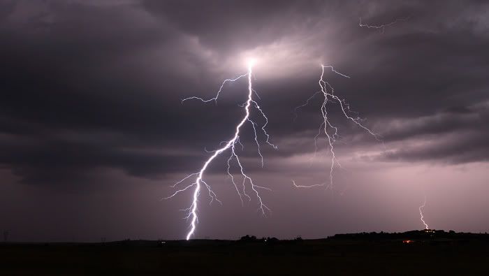
This storm wasnt severe but it did contain some nice staccatos which we captured on video and it was quite photogenic.Some of the bolts strobed,allowing us to capture some daytime pics,but we didnt get anything amazing.This storm also contained some very heavy rainfall and small hail. This storm eventually weakened,but some decent outflow winds from it sparked new storms to our NW.We then went our separate ways

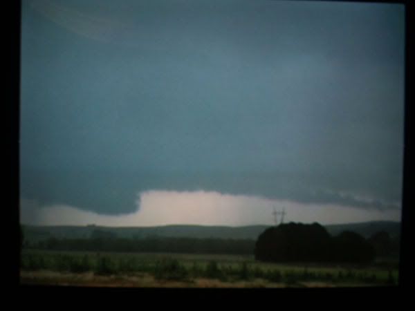
After this , me and my brother got onto a little storm which produced some lovely bolts but little else. This kept us interested for 20minutes,before a much more interesting storm  15-20kms to our NW caught our interest. This storm towards Collector became particualy severe displaying some rather interesting features including a lovely rain free base and nice wall cloud(see below,sorry about the quality) This reigon copped a CG barrage


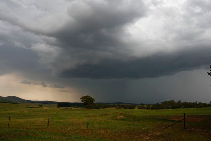
After a while,the rain free reigon got rain/hailed in.We then decided to head north in the hope of getting onto the Collector storm. We core puched a decent storm(not the main black cored storm) near Tarago encountering very heavy rain and some flash flooding.Once on the other side of this storm,we got glimpses of the Collector storm again with a gustfront(see below)


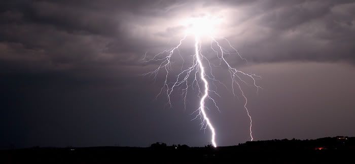
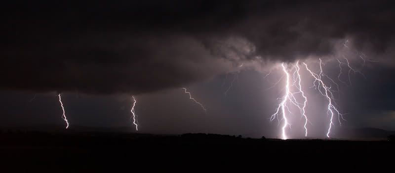
This storm slowly weakened but it produced some very nice lightning as it moved towards Goulburn


All in all a great days chasing. Slow to start with,but worth the wait!!!!!


« Last Edit: 24 November 2007, 11:45:21 AM by David C »

Offline Harley Pearman

  • Barrel tornado F4
  • *
  • Posts: 584
Re: NSW storms 14 - 21st November 2007
« Reply #29 on: 20 November 2007, 12:53:58 PM »
Hello

On Saturday 17 November, I drove down to the south coast via Braidwood and then onto Batemans Bay. During the afternoon, several small high based pulse cells developed in the Braidwood area and more small storm cells propagated along the ranges to the west of Batemans Bay.

Initially each cell produced a good updraft tower but from 3 pm, the cells merged with one another to become one complex of cloud.

The Braidwood storm produced a sustained shower and occasional cloud to ground lighting strike but certainly not enough to warrant filming it.

I took numerous photos of cloud towers as they propagated along the ranges.

On Sunday 18 November, I drove back to Goulburn and during the afternoon, small storm cells propagated to the east of town and to the north west of town.

The storm to the north of town produced some good cloud structure but I decided not chase the core of this storm down because after I took some photos of it, the storm cell began to weaken.

The storm to the east of town produced some good cloud structure albeit briefly before it too weakened.

Thunderstorms were propagating right along the ranges but most cells were short lived and did not travel far. I took numerous photos of cloud towers and cloud structure as the cells matured.


Harley Pearman


« Last Edit: 24 November 2007, 11:45:39 AM by David C »