Author Topic: April 30 to May 8, 2007 - Including the Greensburg Kansas EF5 Tornado  (Read 81758 times)

0 Members and 1 Guest are viewing this topic.

Offline David C

  • Global Moderator
  • Barrel tornado F4
  • *
  • Posts: 643
  • Gender: Male
    • Thunderbolt Tours Storm Chasing Adventures
Chuck Doswell seems to think so to Jeff!  see comments on this thread http://www.stormeyes.org/tornado/blog/archives/2005/08/appalling_examp.php

Diverting the thread slightly, these guys have obviously made it their mission to shoot dangerously up-close footage and, for quite young guys, the would be making a nice 'little' profit -- I know some cuts of quality newsworthy footage (not specifally these guys) have fetched around 30,000 US - of course this depends entirely on what you have / who else has similar and whether CNN etc want it. I have no problem about individuals risking their own lives....each to their own. A different story if your actions start putting others at risk.

Personally, when there are tornadoes on offer, I would always like to be somewhat close - say 0.5-1km although that depends on the situation. I would not have liked to have been within 2 km of the Greensburg monster at that time of night, in fact I rather not chase tornadoes at night at all.

Anyway good stuff Jimmy look forward to seeing your lp and the tornadoes.
Storm Chaser,
Thunderbolt Tours - USA & Australia Storm Chase Tours
www.thunderbolttours.com

VORTEX

  • Guest
Since I've been ill this is about as close as I get to chase...I was NOWCASTING for a couple of intercept spotters for a TV station....Here are some interesting radar images...One is the BWER from the debris..
[attachthumb=#]
« Last Edit: 09 May 2007, 09:41:58 AM by VORTEX »

Jeff Brislane

  • Guest
Dave,

If I was there i'd be looking to get within 1km of a nice f2 tornado like that one, allthough I'm not sure about 100m. I agree that as long as you only put yourself at risk than so be it and I would be bored if the tornadoes were always a couple of km away, unless of course there was good structure.

Some people do it for the thrill and not just the science. However that night time wedge is just frightening, what a beast! And what is it about night time wedges over there? They seem to be far more common than day time wedges.

Jeff.

Offline Jimmy Deguara

  • Australian and Tornado Alley storm chaser
  • Administrator
  • Wedge tornado F5
  • *
  • Posts: 2,218
  • Gender: Male
  • Storm Chaser since 1993, Tornado Alley 2001
    • Australia Severe Weather
Hi,

Jeff, night time wedge in this case developed because the storm moved into a volitile environment after breaking the cap 3 hours or so before sunset. I can tell you there were relatively few chasers on the night time wedge supercell considering there were so many chasers out and about.

Anyway, after the Clinton lightning and rain, we chased yet another tornado warned supercell. We actually booked the hotel in my target region and the storm came towards us so a relatively short chase (thanks to Macca for alerting me and getting me excited haha). We then headed after it. Canons and power flashes hammered the area near the US 75 border area of Sherman - nice green glows. Of particular interest at the time rotation was being detected there was a prolonged green glow of 5 seconds over about a 100 metre spread or more. This did not coincide with a lightning strike from our perspective. It could have been straight line winds of course but worthy of note.

There has been no rest for several days now.

Regards,

Jimmy Deguara
« Last Edit: 09 May 2007, 07:05:18 PM by Jimmy Deguara »
-------------------------------------
Australian Severe Weather
www.australiasevereweather.com

Australian Thunderbolt Tours
www.thunderbolttours.com

Phone  0408 020468  (International :  61  2  408 020468)

Offline Macca

  • Elephant Trunk F2
  • *
  • Posts: 171
In any given strongly unstable environment, the conditions are often more favourable for wedges after dark as the lower levels cool, the LCL height lowers, and thus not only does this increase the chances of tornadoes (alone), but it also provides for better conditions for wedge tornadoes.  It is also common here that the LLJ increases sigificantly during the evening/overnight (again providing another factor for increased tornadic activity after dark in a strongly unstable environment). 

I guess when you think about it, the lower the LCL, the less "wide" a tornado needs to be to meet the wedge definition (wider than it is high?).  So to have an LCL of just 200m (700ft), the tornado would (only) have to be 250m wide to meet the definition.  Certainly not a large tornado on the grand scale.   

Macca

Offline David C

  • Global Moderator
  • Barrel tornado F4
  • *
  • Posts: 643
  • Gender: Male
    • Thunderbolt Tours Storm Chasing Adventures
Yes, anecdotal at least, it does seem to me too that wedges are more common at night. In saying that when you are talking abut a 1+ mile wide tornado then all the standard tornado parameters would be at the top end of the scale. It is just a question of when the storm moves into a suitable environment, day or night. As you guys have said, the increase in the low-level jet (this possibly as 'inhibitory' vertical mixing decreases and / or due to baroclinicity via +ve west-east temperature gradient over the sloping terrain of the Plains) would be critical since this increases the low-level shear as well as maintaining ongoing northward advection of moisture (hence a lowering of LCL with nocturnal cooling). This could both intensify and in effect 'bring' the low-level mesocyclone closer to the ground - probably explaining any day/night bias in distribtion of strong violent (and large) tornadoes.

Anyway, good stuff from everyone over there, we are all enjoying the reports immensely back here!
Storm Chaser,
Thunderbolt Tours - USA & Australia Storm Chase Tours
www.thunderbolttours.com

Offline Macca

  • Elephant Trunk F2
  • *
  • Posts: 171
Hi all,

We have a few days to catch up on (I think) after the hectic 2 days in Kansas.  We are still yet to go through our videos of the Kansas outbreak/s so there may be more tornadic action yet that we aren’t sure about. 

On Sunday we left Hutchinson, Kansas and headed S.  There was a well defined surface (outflow) boundary lying from just east of Hutchinson, Kansas off to the WSW to near Woodward in Oklahoma where this intersected the front which was aligned nearly north/south along the Oklahoma/Texas border.  Warm moist air was present to the south and east of these boundaries and was being advected northward with a 25-30knt south easterly low level jet .  The upper trough (which was still sitting to the west) was providing for some nice mid to upper level speed shear with a 40-50knt mid level jet from the south (which proved to be problematic as you will soon read).  CAPE to the south of this boundary in western Oklahoma was increasing rapidly (into the 3000-4000j/kg range) as cloud cleared and heating took place.  Storms were ongoing from the previous night along a line from east central Kansas to north central Oklahoma.  As we were leaving the motel at about 11am, one of these cells to our south (near Medicine Lodge) became tornado warned after storm spotters reported funnel clouds.  We didn’t chase this cell as we wanted to target north western Oklahoma where there was at least some cap in place and convection had not yet fired. 

As we dropped west and south, 3 or 4 isolated storms developed further S and W along the line along the Tx/Ok border.  We entered Oklahoma and had decided we needed to get to Seiling for fuel before commencing an intercept on one of these storms (which were now only 20-30mi west, 30-40mi south west and 40-50mi south south west of us).  The storm to our west exploded as we were fuelling up and the inflow into this cell even from this distance was amazing.  The winds at the surface picked up from 15knts to 25-30knts with gusts of up to 40knts as this cell just opened up a nice hole in the cap and the warm, moist, unstable air just raced to it.  At the time, we didn’t realize that this cell was sitting on the intersection of the two boundaries otherwise we probably would’ve targeted it.  We did hear that it was tornado warned and was capable of producing hail up to the size of baseballs but it was looking slightly grungy on radar (with other showers developing around it).  We decided to intercept the next storm along the line to the SW so we pushed west and then South to Carmargo but whilst we were doing this, the areas between each storm started to fill in with new convection and by the time we reached Carmargo, we were now watching a line of storms with embedded supercells.  This is probably a result of weak capping.  We watched for a while incase any of the embedded supercells was able to keep it act together but to no avail.  There were quite a few other chasers around who were doing the same thing.  One small glimmer of hope was the southern end of the line…there were more cells down into north western Texas but there was a 20mi break in the line before those cells.  I think every chaser in the area had the same idea that maybe this semi-tail-end charlie might get the job done and soon every chaser and his dog was heading south towards Leedey for the intercept.  We got there and headed west to get closer and it looked ok for a short period of time as an RFD wrapped up a weak wall cloud but it rapidly gusted out.  That was pretty much game over unless you wanted to drive another 150mi south to get on the southern end of the next line coming up.  We called it a day in Leedy at about 6:30pm and headed south and east to Clinton, Oklahoma where we stopped for the night.  With the line of storms to our west extending way way back down into south western Texas, we figured we’d at least get a decent lightning show as it pushed slowly eastwards.  Individual cells were moving NNE but the whole line slowly progressed east and we were treated to a great train-effect lightning show which went from about 8:30pm through to about 2am when the last storm of the line finally passed over us.  It started off with mostly in-cloud flashes with a ratio of about 1 CG to 50+ in-cloud flashes…then while we were sitting in our room there was a MASSIVE flash (that’s all I saw).  Chris was looking out the window from his bed at the time and saw the CG hit something across the street (about 100m away) and saw the sparks flying everywhere afterwards.  We both crapped our pants as the thunder was instantaneous (we were at or very close to the maximum thunder volume distance).  After this, the storms started to produce some AWESOME CG’s which hit all over town around us on and off in barrages of 10-15 minutes for the next 3 hours.  Just as we thought one lot was over, another would start coming up from the SW and within 10-15 minutes it was on again.  We had countless strikes within 1.5km and although I took about 300 frames with my digicam (all short duration due to the hotel lights), I didn’t manage to get 1 CG…haha.  We got plenty on video though . 

Yesterday, we knew it would be very marginal so we had a very casual day to relax from the craziness that had been the past 3 days.   There was a very slight chance that a storm would kick up on a weak OFB that was sitting right along the Red River (Tx/Ok border).  Weak instability was pushing westward behind the previous night’s MCS as easterly flow returned to the west as a result of the upper trough STILL sitting off over the four corners region.  We dropped S from Clinton, OK to Vernon, Texas where we checked some data and realized that the chances of anything going up would be better slightly further east where a weak low had formed on the red river near Wichita Falls.   So that became our destination.  We checked into a motel and kept our eye on the radar and by 6pm a small area of storms developed about 70mi to our east and was moving NE.  This is the stuff Jimmy got on to.  From reports I’ve read, it became briefly supercellular, produced some near-golf-ball hail and was tornado warned for Doppler indicated rotation (but never produced).  We decided not to chase as it would’ve put us over 100mi from Wichita Falls and we really needed a break. 

Today was a really relaxing day for us and it want from being just that to being an AWESOME chase in the space of 2 hours – over here, they call these days “sleepers” where no one really expects massive fireworks but then it turns out to be really good!.  We stumbled out of bed at around 10:30am to check the forecast charts.  No one was expecting much but I think everyone had their eye on the outflow boundary from the previous night’s convection over north western Texas which was draped WSW-ENE across Abilene to Dallas.  15-20knt ESE’ly winds at 850mb to the south of this boundary were being over run by 30-35knt SW’ly (just enough shear for supercells).  A N/S aligned line of cirrus was drifting across the boundary preventing much heating until after lunch but after that, heating took place nicely and the atmosphere began to destabilize.  We stuffed around all morning and kinda watched the sat pic and radar. SPC weren’t too confident in severe storms but had a 2% tornado chance and 15% hail and wind chance for the area just in case.  At about 2:00pm I was checking through the latest obs and SPC meso analysis data and noticed a nice pocket of moisture converging around the Abilene area.  With the heating and the moderate influx of moisture, CAPE values had gotten up to 3000j/kg over that area (interesting!).  A quick check of the sat pic showed an enhanced cumulus field in the area and within 30 minutes showers and weak storms were showing up on radar along the boundary from Abilene to N of Mineral Wells and the tops were getting up to around 40-45k feet. 

We casually got our things together and headed out the door and dropped S from Wichita Falls to Graham.  By the time we got there, two cells were looking the most impressive.  One NE of Abilene and one to our west.   We headed west from Graham with the thought in mind that we’d hit the Abilene cell as it was clearly looking stronger than the other one but as we neared the first cell which had moved just N of our west road, it produced a nice little wall cloud and a few nice CG’s.  We stopped to watch for a short while before we blew it off for the cell which was now nearly due W of us about 20mi away.  The first cell moved off to the N but maintained its structure but as we neared the main cell, we realized that this was the main show.  A nice low-hanging wall cloud was present as were mid-level inflow bands.  We kept heading west to get closer and eventually stopped in a clearing (there are quite a few trees in this area) and watched as this supercell rotated nicely as it ambled slowly due north.  Inflow from the east in the lower levels was clear and this cell had some fantastic structure for most of its life.  The wall cloud lowered several times and dragged along the ground for some time.  We videoed this and have since heard reports of some weak tornadoes with this – we’ll have to review the video to confirm but some of this “ground dragging” may’ve been one of these weak tornadoes (although it didn’t look to be rotating that strongly so who knows).  We moved further west and then north to sit just N of Throckmorton where we set up and watched this cell which sat just off to the west of us with its nice laminar structure.  It put down a nice RFD at this point but again we didn’t see any tornado.  We pushed a little further N as the cell put out what looked to be its last “cycle” (if you can call it that) as another RFD pushed out quite strongly and appeared to undercut the base.  We were fairly close to it at this point (<1mi) and were hoping it was going to put down a weak tornado but it didn’t. 

We let it pass off to the N and whilst taking a short break (2 mins) we noticed the line of storms we had been watching all morning and afternoon had really raced eastwards in the last few hours and was now merely 15mi to our west.  Soon a long low guster came in to view and it was flying along!  We dropped back into Throckmorton and were going to head east to get into a position to video/photograph this 4-layer guster but another isolated storm had developed ahead of the line to the ESE of Throckmorton and had blocked our east road option.  This guster was looking mean and green and we pushed east as far as we could without going into the isolated storm and we stopped for some video/pics of the guster.  This was all fine until one part of the guster took on a more base-like look appeared to be rotating rapidly and was racing right towards us.  Not wanting to take any chances, we decided we’d rather encounter some hail and heavy rain than get caught in front flank rotation.  So we punched into the rain from this cell (which was starting to look really nice on radar and was showing up 1.5 inch hail and 65dbz echoes at 20,000ft on wx worx).  We encountered a short barrage of pea sized hail and a handful of larger stones possibly up to 2cm before we broke out into the front of it…and what a sight!  This little storm had gone nuts.  For some reason, the air we came out into was significantly more warm and moist than we had had earlier in the day and this cell was just feeding on it.  A nice guster had developed on the front flank (NE quadrant) but the base was still evident on the south eastern quadrant and we stopped for a few brief photos of this near Newcastle.  It was looking really green and the lightning picked up rapidly with some CG’s striking out in front of it at this point.  We took off east for a bit to get ahead of it and about 3mi down the road, we stopped again for a look and it although it appeared to have a HP’ish look to it a wall cloud had developed under the base on the front flank in the notch.  It was rotating rapidly and it produced a brief stout cone-shaped funnel and we thought it was going to do the job but the funnel disappeared almost as quickly as it developed and the RFD that wrapped up the wall cloud pushed out and the cell became outflow dominated.  We had to move again at this point as the cell pushed out strongly towards us and was threatening to blast us with outflow and hail.  A gust of 76mph (122km/h) was reported just to our N shortly after this.  For the next 15-20 minutes we raced east and stopped and raced east and stopped to get photos of this now very impressive guster.  Eventually, the outflow pushed too far ahead of the rain and it weakened so we stopped in Jacksboro for dinner before heading back here to Wichita Falls.  250miles, 2 supercells and an awesome squall line later, we are back in our motel room fairly impressed at what we saw today given the low expectations.  Its amazing what can happen with some moderate instability and some decent shear.  There are two (possibly 3) tornado reports from the first storm we were on but as mentioned above, we did not see anything which screamed “tornado”.  The first storm report was from before we got to the storm but the others, we were there watching.  There were several interesting lowerings but at the time we didn’t think they were tornadic.  We’ll have to review our video but we were in a pretty good position for quite a bit of the time. 

Link to some pics from Sunday (Day 10)…

http://macca.bsch.au.com/gallery/20070506

Link to some pics from today (Day 12)…

http://macca.bsch.au.com/gallery/20070508

Macca & Chris

(*VERY* happy!)

Offline Michael Bath

  • storm chaser
  • Administrator
  • Wedge tornado F5
  • *
  • Posts: 1,602
  • Gender: Male
    • Australian Severe Weather
Hi all - here are Jimmy's photos during this severe weather outbreak. Click on the links for the full set of images on each date.


Wednesday 2nd May Click on this link for all images

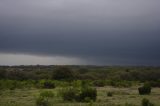
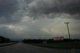
Extreme SW Texas south of Junction. Storm became tornado warned as basically a tailend charlie storm and remained surprisingly tornado warned for some time. We saw but did not film or photograph the rain slot trying to get better position. We then headed back east with it - you can see the squall line - very turbulent motions!


Thursday 3rd May Click on this link for all images

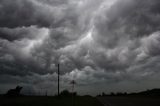
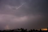
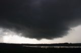
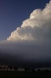
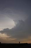
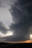
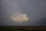
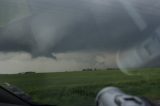
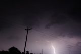
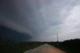
We hung around Waco, Texas during the afternoon on this particular day. We left the mess of the tornado watch box in east Texas given conditions were still ripe and recovering in this region. Seeing a persisting weak cell visually and on radar, we headed north to intercept it. It looked rather weak - very narrow anvil. From the time We proceeded west towards the cell north of Hillsboro, Texas - the storm had intensified and developed a cow catcher structure, a crisp side anvil and dangerous anvil bolts. The lightning bolt action became a barrage lasting at least 5 to 10 minutes. We finally were able to find a good location to stop.

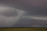
A wall cloud developed and finally the severe warning turned to a tornado warning. The whole scene was in high contrast with good time lapse from two video cameras. The wall cloud being up close seemed to either redevelop or perhaps I lost perspective being so close.

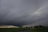
Finally we dropped south and the wall cloud NW of Hillsboro was rotating rapidly. The clear slot introduced a rain shaft but no tornado seemed to make contact.

The storm met a quick demise into the typical LP supercell shrink stage. It ws quite nice to see the inflow persist right up until complete obliteration.

A fantastic chase and no chasers around - just the pick up trucks.


Friday 4th May Click on this link for all images


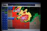
My friends and I were late to the tornado travelling along 160 when the tornado was crossing 183, and Greensburg, Kansas. Our target was SW Kansas and we remained in the area for some time at Anthony then met Macca and Chris at St Johns. We had initially moved towards cells erupting in eastern Texas panhandle and extreme NW Oklahoma and were just too late for those tornadoes and then headed north taking a bad road option (well the intent I guess under pressure was to intercept the storm near Pratt).

We were stopped amongst the very long damage swath along 183 near Greensburg, Kansas. I was sickened to think what it had done to Greensburg at this point given the extensive damage to power poles as well as a house. We headed back to Dodge City, Kansas and passed numerous emergency vehicles. The mood was one of sadness for the rest of the night.

I have checked video although at best I think besides stills of the structure, only one possible tornado on my images thus far. Brad has a very high possible tornado looking image - perhaps the new developing tornado?

Edit: Since this writing, Jimmy Deguara has documented images of the Greensburg tornado

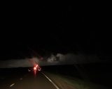
More about the video stills are mentioned in this post:

http://www.australiasevereweather.com/forum/index.php?topic=424.msg3521#msg3521
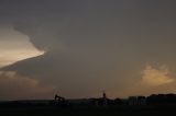


Saturday 5th May Click on this link for all images

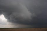
Chased with Tim and Kay Marshall, The Eades couple and a few others in the crew. Intercepted a supercell organising and quickly developing a wall cloud in the rural areas SE of Greensburg and SW of Pratt, Kansas. There was a brief touch down up close and personal here. We then headed generally northeast and we noted at least 3 more brief touchdowns along the marathon trip north.

We then let this go and dropped south to the east of Greensburg, Kansas. We filmed an area of rotation and had lost contact with the crew. It was at this time we decided to to head back to Dallas - drop-off and pick-up. Luckily so, as we arrived well into the early hours of the morning. We off course hear the large tornado threat once more on the NOAA radio as we dropped south. Tim Marshall got a multi-vortex of one of the tornadoes.


Sunday 6th May Click on this link for all images

This was a basic let down - my target was Woodward, Oklahoma but we were unable to get to the storm on time so we opted for activity south. Nothing really happened and all south action collapsed. The Woodward storm went to produce tornadoes in Wichita County, Kansas. Of course we enjoyed the cannons lightning bolt and thunder combinations:)


Monday 7th May Click on this link for all images

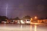
We were inside the core of the storm that began in Denton county and chased it northeast to Sherman. Made a wrong turn and missed the wall cloud. Some incredible lightning "cannon" and power transformer glows here. Now what was interesting was one transformer glow that lasted about 5 seconds over a few hundred metre length. Was it strong winds? It was near the shear region within the storm although can't tell exactly.

Had driven in hail to less than the size of golf balls in the core and torrential rain.


Tuesday 8th May Click on this link for all images

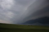
We started out near Gainsville, Texas and then headed WSW towards Archer City. We then basically gave it a try to intercept the Throckmorton supercell but only could get in time for a cell developing to its east. This exhibited interesting behaviour as it became tornado warned. The wall cloud was visible to our SW and then a thick rain shaft rotated around the east side. Quite spectacular but the rian spoiled the show. A nice shelf cloud followed us back.


We await the next decent system. Thanks to michael for preparing images once more.

Regards,

Jimmy Deguara
« Last Edit: 19 June 2007, 04:35:46 PM by Jimmy Deguara »
Location: Mcleans Ridges, NSW Northern Rivers
Australian Severe Weather:   http://australiasevereweather.com/
Lightning Photography:   http://www.lightningphotography.com/
Early Warning Network: http://www.ewn.com.au
Contact: Michael Bath

Offline Macca

  • Elephant Trunk F2
  • *
  • Posts: 171
FWOR!  Nice pics Jimmy!!!  Great to see how things looked from slightly different areas too!

We went on a very local chase here this afternoon.  Some moderately strong storms developed to our SSW late this afternoon and moved northwards towards us so we drove about 20mi south of here (Wichita Falls).  It pushed out a nice guster and some infrequent CG's.  It was moving at about 10mph (very slowly) and we basically followed it back to Wichita  Falls and let it run over the top of us.  It had some nice gusty winds and some quite heavy rain.  There is now a large area of thundery rain sitting over us with one flash every 3 to 4 minutes but no bolts  :( .  Here are some pics...

 http://macca.bsch.au.com/gallery/20070509

The next few days are looking very dubious (although so were the last two...hehe...but moreso over the next few days).  Tomorrow might be ok for some more thundery action as the upper low which has been sitting over the southern Rockies for the last 6 days finally moves off to the east (over us) but after that, upper level ridging looks to take ahold of the plains.  There are two stormy options to play with when this happens...one is to head east into the lower Mississippi valley which will be ahead of the upper low and will have ample moisture for some pulse storms.  The other option is to head up to the northern plains (Nebraska & the Dakotas) and play any upper troughs which ride across the top of the ridge.  There is quite a bit of moisture up there as well and I think most chasers who are on their "chasecation" during this period will take this option as the first upper trough looks to be drifting over the Dakota's Friday/Saturday/Sunday. 

Macca & Chris

[Edit:  Just as I pressed "send", a massive FLANG just hit about 300m away!!]

Offline Mike

  • Australian Severe Weather Moderators
  • Wedge tornado F5
  • *
  • Posts: 1,348
  • Gender: Male
  • Dry season here...boring!
    • http://StormscapesDarwin.com
Top stuff fellas!  Just great photos and 'commentary' of the past day's events.  The severe weather is getting plenty of television coverage here in OZ!  Certainly has been a fierce outbreak of tornadoes this season in the US.  Has been a pleasure to read your reports one and all.  probably makes it more exciting considering we aren't there to witness the storms!  Dang!

From viewing the WRFs there's still some stuff to come although some areas that had numbers like -8 LI's, CAPE 4000-5000 were stuffed up by mid to high level frontal cloud that really messed things up and wrecked any tornado formation.  Certainly some weak shear expected over the next day of less than 40kts in the low to mid levels but southern TX and parts of Oklahoma still looks inviting on the models.

Pity that developing low on the east coast is weakening, too much cooler water underneath!  wuold have been a doubleheader to head out there if that was strengthening to hurricane status!

Good luck and keep safe guys.  Enjoying the posts from you all!

Mike, Darwin.
Darwin, Northern Territory.
StormscapesDarwin.com
Lightning Research 2010/14

Offline Jimmy Deguara

  • Australian and Tornado Alley storm chaser
  • Administrator
  • Wedge tornado F5
  • *
  • Posts: 2,218
  • Gender: Male
  • Storm Chaser since 1993, Tornado Alley 2001
    • Australia Severe Weather
Macca and Chris,

The storms you have intercepted includig the night tornado are impressive - including the storm in Throckmorton county a couple of days ago! You have done well.

Hope we can meet up today for an Aussie, Slovenian, and Finnish BBQ. And of course some alcohol somewhere in there:) Be good to echange the current exciting moments!

We are still in Lindsay, Texas near Gainsville at the Lindsay Inn.

Regards,

Jimmy Deguara
-------------------------------------
Australian Severe Weather
www.australiasevereweather.com

Australian Thunderbolt Tours
www.thunderbolttours.com

Phone  0408 020468  (International :  61  2  408 020468)

Offline Jimmy Deguara

  • Australian and Tornado Alley storm chaser
  • Administrator
  • Wedge tornado F5
  • *
  • Posts: 2,218
  • Gender: Male
  • Storm Chaser since 1993, Tornado Alley 2001
    • Australia Severe Weather
« Last Edit: 14 May 2007, 05:16:00 PM by Jimmy Deguara »
-------------------------------------
Australian Severe Weather
www.australiasevereweather.com

Australian Thunderbolt Tours
www.thunderbolttours.com

Phone  0408 020468  (International :  61  2  408 020468)

Offline Jimmy Deguara

  • Australian and Tornado Alley storm chaser
  • Administrator
  • Wedge tornado F5
  • *
  • Posts: 2,218
  • Gender: Male
  • Storm Chaser since 1993, Tornado Alley 2001
    • Australia Severe Weather
Hi,

Just so that people know this is the supercell that exploded and became a monster only an hour and half later to level Greensburg:


We were onto the other tornado warned storm that eventually collapsed so we raced north for this cell - the rest is history. The marathon catch up and finally move into damage path - 4 miles of damage along 183 - levelled house, tree branches, gas rupture and snapped power poles.

Regards,
Jimmy Deguara
« Last Edit: 14 May 2007, 05:37:11 PM by Jimmy Deguara »
-------------------------------------
Australian Severe Weather
www.australiasevereweather.com

Australian Thunderbolt Tours
www.thunderbolttours.com

Phone  0408 020468  (International :  61  2  408 020468)

Offline Jimmy Deguara

  • Australian and Tornado Alley storm chaser
  • Administrator
  • Wedge tornado F5
  • *
  • Posts: 2,218
  • Gender: Male
  • Storm Chaser since 1993, Tornado Alley 2001
    • Australia Severe Weather
After two attempts at obtaining video stills, I have been able to further solve the confusing events of the evening, what was observed, and importantly, uncover a few probable sightings of the tornado based on video. The conditions were very difficult for chasing given we were late to the event and given the tornado (based on other chaser accounts) the tornado became rain-wrapped for a while only to emerge as it crossed and created more damage on route 283 north west of Greensburg. The video evidence of the probable tornado is consistent with this latter stage.

Also included are various images of the damage along the road, the storm structure and some of the lightning.


All video stills available here:
http://australiasevereweather.com/video/stills/2007/20070504.html

Regards,

Jimmy Deguara
« Last Edit: 19 June 2007, 02:04:28 AM by Jimmy Deguara »
-------------------------------------
Australian Severe Weather
www.australiasevereweather.com

Australian Thunderbolt Tours
www.thunderbolttours.com

Phone  0408 020468  (International :  61  2  408 020468)

Offline David C

  • Global Moderator
  • Barrel tornado F4
  • *
  • Posts: 643
  • Gender: Male
    • Thunderbolt Tours Storm Chasing Adventures
Fantastic mate - I knew you must have had something on video - also some good shots of the structure there!!
« Last Edit: 18 June 2007, 06:30:41 PM by Jimmy Deguara »
Storm Chaser,
Thunderbolt Tours - USA & Australia Storm Chase Tours
www.thunderbolttours.com