Author Topic: NSW Storms: 23 - 26 Feb 2009 - including the Warragamba Classic Supercell  (Read 26130 times)

0 Members and 1 Guest are viewing this topic.

Offline Harley Pearman

  • Barrel tornado F4
  • *
  • Posts: 584
Re: NSW Storms: 23 - 26 Feb 2009 - including the Warragamba Classic Supercell
« Reply #15 on: 25 February 2009, 02:28:43 PM »
I captured some lightning from the night time storm of 23/2/2009. I took some short film clips as the storm approached Blacktown and have taken the photos from the clips taken. I was on Bungarribee Road near the corner of Panorama Parade Blacktown and facing west.

The lightning varied from sheet to cloud to ground strikes although as the storm passed overhead it weakened.

Only 1 mm of rain fell where I live and the rain was not heavy. It is the first storm I have captured in Sydney for a while because I have been away on holidays travelling and I was not in Sydney for the 21/2/2009 storm event.

Further, I saw the Warragamba Storm of 23/2/2009 from my work office window at Auburn but I had no camera with me. By the time the storm cell reached Auburn , it produced nothing more than a brief shower and a few rumbles of thunder.

Storms in the Sydney basin 23/2/2009 produced 1 mm to 8 mm across most of Western Sydney with Warragamba Dam receiving 16 mm and Katoomba receiving 10 mm. A separate storm dropped 53 mm at Sackville, 43 mm at Lower Portland and 37 mm at Wisemans Ferry north and north west of Sydney.

Harley Pearman 

Offline Richary

  • Barrel tornado F4
  • *
  • Posts: 680
  • Gender: Male
Re: NSW Storms: 23 - 26 Feb 2009 - including the Warragamba Classic Supercell
« Reply #16 on: 25 February 2009, 03:53:59 PM »
Thanks for those pics Harley. From the office in Chatswood yesterday I had gone outside at one point and the sky was clear. Went back outside an hour later and the blow off from the top of the Warragamba storm anvil was covering the sky. That was when I checked the radar and realised home could be a target. Not knowing if I had disconnected all my radio gear from antennas (the mast here has been hit once if not twice) I decided to take an early mark to go home and check.

Unluckily by the time the storm got to Rydalmere (Parramatta area for those not in Sydney) it had died off pretty much. My total rainfall was also 1mm, mainly from the later storms.

Got one crawler photo from the attempts last night when the later squall front came through but it's hardly worth keeping, let alone posting. Again, that storm while lighting up the sky well further west over the horizon as it approached but died before it got here.

The Saturday 21/2 storm as it came through suddenly dropped a barrage of CGs around 12:30, generally in the direction I get the worst view (and not expecting them as there hadn't been signs as it approached - just a few rumbles in the sky - hadn't driven out to find a better viewing spot as no structure was visible in any case). Then the small hail, a few more CGs and everything quietened down again.

A bit of late season action, but it has in reality been pretty quiet for a while. Now if we had been living near Singleton, north coast or Brisbane it would have been a much better season. Oh well.

Robert1984

  • Guest
Re: NSW Storms: 23 - 26 Feb 2009 - including the Warragamba Classic Supercell
« Reply #17 on: 25 February 2009, 04:26:29 PM »
I am sooo jealous  ::) South Australia is in admist of a very long severe thunderstorm drought that doesnt show any signs of breaking anytime soon :-( which is driving me nuts as i wanna go on a storm chase

Offline Mike

  • Australian Severe Weather Moderators
  • Wedge tornado F5
  • *
  • Posts: 1,348
  • Gender: Male
  • Dry season here...boring!
    • http://StormscapesDarwin.com
Re: NSW Storms: 23 - 26 Feb 2009 - including the Warragamba Classic Supercell
« Reply #18 on: 25 February 2009, 06:00:51 PM »
Beautiful structures, lightning and colours from everyone!  That person walking across the reserve with that big CG must have had them worried Con!  A great read of all the posts - so many I had to grab a coffee!  I'm enjoying it immensely!
Darwin, Northern Territory.
StormscapesDarwin.com
Lightning Research 2010/14

Offline vrondes

  • Multi-vortex F1
  • *
  • Posts: 77
Re: NSW Storms: 23 - 26 Feb 2009 - including the Warragamba Classic Supercell
« Reply #19 on: 26 February 2009, 03:32:23 PM »
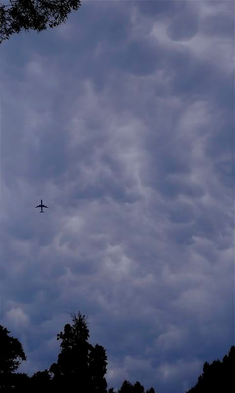
Glad you had the perspective of witnessing that supercell from close by Jimmy, some nice structure in your shots. The shot I took was around 3.30 , when the inflow bands were running out of fuel. The anvil  umbrella put out a long lasting and slow moving mammatus display well beyond 4pm,


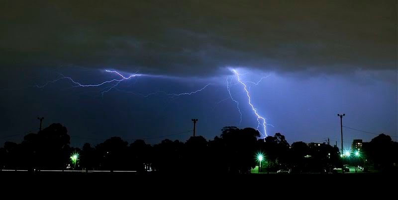
The nine o'clock lightshow had a fair bit of stagefright and barely made it to Parramatta,


Richly coloured pano there Jeff, looking forward to some more,
Darinka, fabulous colour in your Illawarra lightning shots, and Mike, I reckon they "just keep on walkin', and will only take note
of what's going on when there is hail about, Cheers, Con.


Offline Richary

  • Barrel tornado F4
  • *
  • Posts: 680
  • Gender: Male
Re: NSW Storms: 23 - 26 Feb 2009 - including the Warragamba Classic Supercell
« Reply #20 on: 27 February 2009, 11:44:07 AM »
Con, I also spotted what I thought was probably mammatus from the afternoon effort but it wasn't as clear as yours in the photo I took. Good to have it confirmed though.

Yes as the evening squall line approached I thought I would be in for a reasonable show the way the sky was lighting up, but it all fizzled by the time it arrived to me at Rydalmere. Shame my job only involves being on high building rooftops during business hours and I can't get access after hours!

Offline Michael Bath

  • storm chaser
  • Administrator
  • Wedge tornado F5
  • *
  • Posts: 1,602
  • Gender: Male
    • Australian Severe Weather
Re: NSW Storms: 23 - 26 Feb 2009 - including the Warragamba Classic Supercell
« Reply #21 on: 28 February 2009, 01:55:52 AM »
The leftovers of the instability produced a number of coastal storms off the Northern Rivers on the 26th. There were also some weak cells on the ranges between Glen Innes and Deepwater and SE QLD with a few strikes on tracker. The cumulus depth decreased by late afternoon but still looked nice around sunset. An isolated fall of 68mm occurred at Barneys Point (near Tweed Heads) as some of the larger clouds clipped the land.


Location: Mcleans Ridges, NSW Northern Rivers
Australian Severe Weather:   http://australiasevereweather.com/
Lightning Photography:   http://www.lightningphotography.com/
Early Warning Network: http://www.ewn.com.au
Contact: Michael Bath

Offline Jimmy Deguara

  • Australian and Tornado Alley storm chaser
  • Administrator
  • Wedge tornado F5
  • *
  • Posts: 2,218
  • Gender: Male
  • Storm Chaser since 1993, Tornado Alley 2001
    • Australia Severe Weather
Re: NSW Storms: 23 - 26 Feb 2009 - including the Warragamba Classic Supercell
« Reply #22 on: 28 February 2009, 01:59:22 AM »
On the 23rd February classic supercell chase, I was making my move for the storm to the north when I passed a chaser, I am wandering who it was? This person was on the road near the end of the road to Badgerys Creek which is where I was coming from. I am seriously curious as to what angle of the storm this chaser got - particularly of the earlier stucture? It would have been the perfect position.

Regarding this storm, the difference in lightning activity was significant when comparing it to the cell to the north of Windsor which was extremely lightning active. Also, Michael, it would be great to see the radar from this storm event posted on here since I have not seen it myself. There was a second cell/core or split that I observed just south of the main core through the rain though I could not photograph it at the time then lost sight of it.

Regards,

Jimmy Deguara
« Last Edit: 28 February 2009, 02:08:20 AM by Jimmy Deguara »
-------------------------------------
Australian Severe Weather
www.australiasevereweather.com

Australian Thunderbolt Tours
www.thunderbolttours.com

Phone  0408 020468  (International :  61  2  408 020468)

Offline Michael Bath

  • storm chaser
  • Administrator
  • Wedge tornado F5
  • *
  • Posts: 1,602
  • Gender: Male
    • Australian Severe Weather
Re: NSW Storms: 23 - 26 Feb 2009 - including the Warragamba Classic Supercell
« Reply #23 on: 28 February 2009, 02:39:18 AM »
Hi Jimmy - the radar was posted with the soundings on the previous page of this thread.

---> Sydney radar loop 23rd Feb

MB

Location: Mcleans Ridges, NSW Northern Rivers
Australian Severe Weather:   http://australiasevereweather.com/
Lightning Photography:   http://www.lightningphotography.com/
Early Warning Network: http://www.ewn.com.au
Contact: Michael Bath

Offline Jimmy Deguara

  • Australian and Tornado Alley storm chaser
  • Administrator
  • Wedge tornado F5
  • *
  • Posts: 2,218
  • Gender: Male
  • Storm Chaser since 1993, Tornado Alley 2001
    • Australia Severe Weather
Re: NSW Storms: 23 - 26 Feb 2009 - including the Warragamba Classic Supercell
« Reply #24 on: 28 February 2009, 03:19:40 AM »
Sorry Michael, I missed that. Do I see a hook echo on the radar at two stages of its life cycle - the frames I refer to are 4:10UTC and 4:30UTC - there is definitely a v-notch earlier. Nice left turn on radar too! The angle of deviation is more consistent with a classic supercell.


Regards,

Jimmy Deguara
« Last Edit: 28 February 2009, 04:55:57 AM by Michael Bath »
-------------------------------------
Australian Severe Weather
www.australiasevereweather.com

Australian Thunderbolt Tours
www.thunderbolttours.com

Phone  0408 020468  (International :  61  2  408 020468)

Offline Richary

  • Barrel tornado F4
  • *
  • Posts: 680
  • Gender: Male
Not quite on topic given the dates, but today's Sydney events don't rate a topic of their own. A cell went over that gradually developed as it moved towards Avalon, only to orange on the radar so not severe. I only mention it because I noticed some nice pileus on top of the cell. In the less than 90 seconds it took me to go to the car and grab the camera for a shot the pileus had intensified and covered the whole top of the anvil so isn't obvious in the photos I took.

When I first viewed it the Pileus was a nice little cap over the top, by the time I took the photo it had covered the whole top of the anvil. <sigh>


Offline Michael Bath

  • storm chaser
  • Administrator
  • Wedge tornado F5
  • *
  • Posts: 1,602
  • Gender: Male
    • Australian Severe Weather
Hi Jimmy - yes I believe so - re: hook echo. Will be much easier to determine these things when the new Doppler radar comes online. Amazing how long it is taking - same with the Gunnedah radar. sloooooooowwwwww
Location: Mcleans Ridges, NSW Northern Rivers
Australian Severe Weather:   http://australiasevereweather.com/
Lightning Photography:   http://www.lightningphotography.com/
Early Warning Network: http://www.ewn.com.au
Contact: Michael Bath