Author Topic: NSW & QLD Severe Storms: 19 - 22 February 2009  (Read 34763 times)

0 Members and 1 Guest are viewing this topic.

Offline Jimmy Deguara

  • Australian and Tornado Alley storm chaser
  • Administrator
  • Wedge tornado F5
  • *
  • Posts: 2,218
  • Gender: Male
  • Storm Chaser since 1993, Tornado Alley 2001
    • Australia Severe Weather
RE: NSW & QLD Severe Storms: 19 - 22 February 2009
« Reply #15 on: 21 February 2009, 02:10:53 PM »
Richary,

You are pretty much on the money but perhaps tending towards the Hunter region as well. I guess we shall check the observations in the morning and see how things have progressed.

Regards,

Jimmy Deguara
-------------------------------------
Australian Severe Weather
www.australiasevereweather.com

Australian Thunderbolt Tours
www.thunderbolttours.com

Phone  0408 020468  (International :  61  2  408 020468)

Offline Richary

  • Barrel tornado F4
  • *
  • Posts: 680
  • Gender: Male
RE: NSW & QLD Severe Storms: 19 - 22 February 2009
« Reply #16 on: 21 February 2009, 03:41:02 PM »
Thanks Jimmy

See what it looks like in the morning though nothing planned otherwise for the weekend. And if I get to the Central Coast and need to stay the night somewhere it's no drama except wouldn't mind getting to Wisemans Ferry on Sunday afternoon as a good singer is on there. But that works from Gosford area as well.

Thought my guesses might have been right but still learning how to read those charts and what might happen from them.

Will check out conditions in the morning and see if I want to go for a drive if things might fire up there. After the last couple of months in Sydney I am suffering severe storm deprivation!

Offline Jason(pato)

  • Elephant Trunk F2
  • *
  • Posts: 136
  • Gender: Male
RE: NSW & QLD Severe Storms: 19 - 22 February 2009
« Reply #17 on: 21 February 2009, 04:04:22 PM »
February 20th 2009

Gday All,

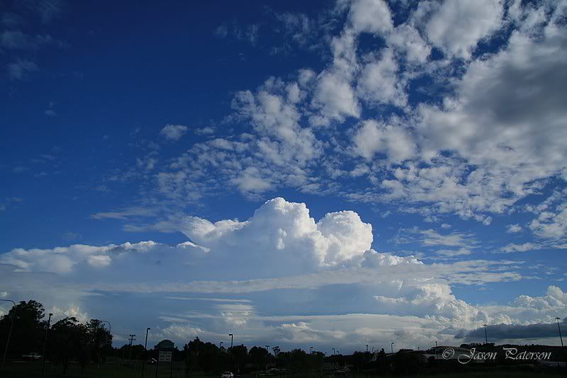
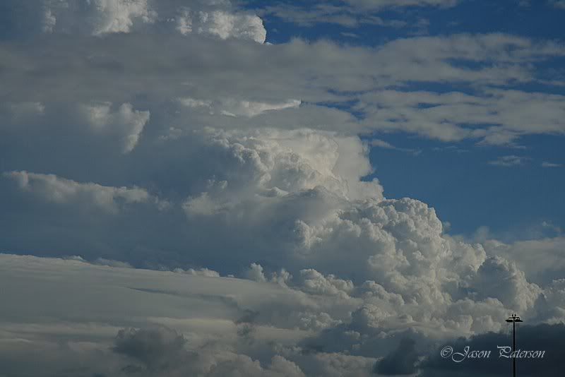
After watching the first storm of the day cruise past Kyogle around 1:30pm (at home in Lismore), letting out a barrage of CGs, I settled in for the arvo and waited for the next round to emerge.  After waiting for an age things looked average indeed around 4pm so I decided to leave the PC and head downstairs and do some gardening. After 45mins or so I stole a glance to the Sth and was absolutely stunned to see some rather solid looking updrafts. At this stage I made the decision to head for a bit of a look. Stopped near the Lismore airport to grab a couple of pics.


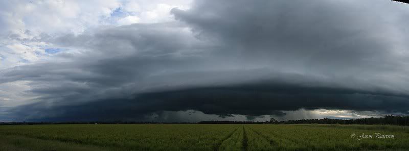
After a quick consultation with Michael Bath, he directed me in the direction of Coraki. So headed towards there but never made it all the way because this is what greeted me, a nice shelf cloud stretching from the coast away to the west.

Decided to do a pano to try and give you an idea of the size.


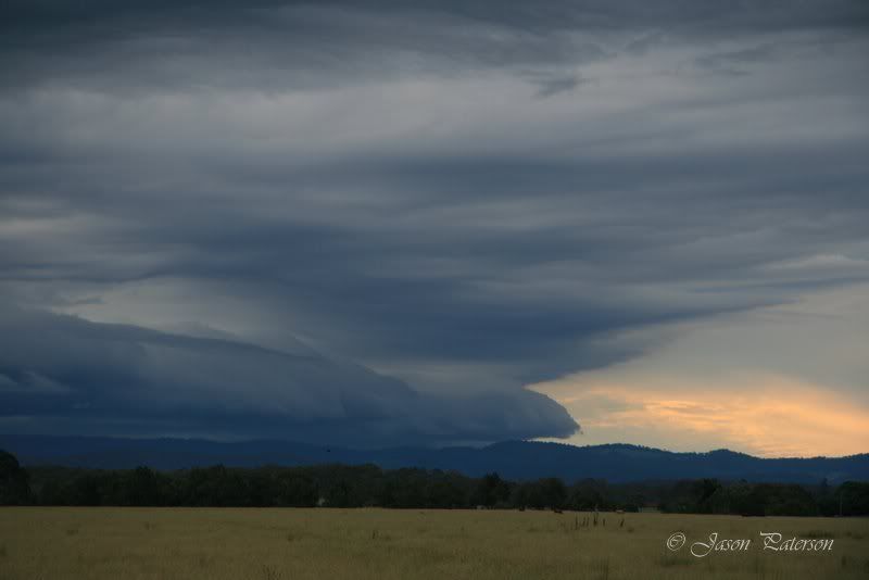
Watched this for a while but it was in a weakening phase so I decided to ditch it and head towards Casino, with the next line advancing from the SW. Once again (like yesterday) there was a lack of lightning, which was quite unusual considering CAPE was adequate enough to put on a show. Unfortunately the above cell proved to be the highlight of the day. The line coming up from the SW looked promising but once I got nearer to it I could see it was weakening as well although another shelf cloud became visible.


I hung around for about 45mins watching the line advance but I only saw one CG the whole time I was there so I decided to head for home.
Today was a day of real frustration. After seeing the Kyogle cell go up so early I had my reservations about the rest of the day.  It looked like it could turn out to be a case of too many storms competing for dominance with it all turning into a mushy mess. This certainly appeared to be the case today (at least in the NRs) with nothing really getting organised for too long before another cell would barge in and try too dominate. Oh well was fun to get out there again, unfortunately the storms couldn't co-operate the way I wanted them too.

Cheers Jason
South Lismore, Northern Rivers NSW.....Supercells are us!!

Offline Jimmy Deguara

  • Australian and Tornado Alley storm chaser
  • Administrator
  • Wedge tornado F5
  • *
  • Posts: 2,218
  • Gender: Male
  • Storm Chaser since 1993, Tornado Alley 2001
    • Australia Severe Weather
RE: NSW & QLD Severe Storms: 19 - 22 February 2009
« Reply #18 on: 21 February 2009, 05:05:04 PM »
Hi,

Hard to believe that today is the anniversary of the hailstorm that devastated the windscreen with giant hailstones - check out the Singleton hailstorm 20th February 2005 can't believe it has been 4 years already.

Good to see the storms active again including the Northern Rivers. And Matt S, that storm looks rather interesting with good contrast and arcus cloud. Did you timelapse it and if so what did you observe?

Tomorrow is looing respectable.

Regards,

Jimmy Deguara
-------------------------------------
Australian Severe Weather
www.australiasevereweather.com

Australian Thunderbolt Tours
www.thunderbolttours.com

Phone  0408 020468  (International :  61  2  408 020468)

Offline Richary

  • Barrel tornado F4
  • *
  • Posts: 680
  • Gender: Male
RE: NSW & QLD Severe Storms: 19 - 22 February 2009
« Reply #19 on: 22 February 2009, 04:50:24 AM »
Looking a bit less promising for Sydney region on this morning's results. Cape & LI is drifting north of Newcastle and the damp area higher up has turned into a dry level. Radar indicates a couple of morning storms moving offshore from Wollongong, but it just doesn't seem like it will fire here today. Cloudy, cool and morning showers just doesn't seem the right pattern for good storm formation. Oh well.

Even if something did build with the current cloud cover getting good photos would be hard.

Offline Michael Bath

  • storm chaser
  • Administrator
  • Wedge tornado F5
  • *
  • Posts: 1,602
  • Gender: Male
    • Australian Severe Weather
RE: NSW & QLD Severe Storms: 19 - 22 February 2009
« Reply #20 on: 22 February 2009, 05:24:09 AM »
Haven't been able to get amongst the storms the past two days so nice to see the shots on here from everyone.

More widespread activity today and tonight expected across NSW and QLD. The sky here is filled with altocumulus castellanus. BoM tipping heavy rain with the storms today. Hopefully it wont end up being too cloudy /clutterred too soon.
Location: Mcleans Ridges, NSW Northern Rivers
Australian Severe Weather:   http://australiasevereweather.com/
Lightning Photography:   http://www.lightningphotography.com/
Early Warning Network: http://www.ewn.com.au
Contact: Michael Bath

Offline Richary

  • Barrel tornado F4
  • *
  • Posts: 680
  • Gender: Male
RE: NSW & QLD Severe Storms: 19 - 22 February 2009
« Reply #21 on: 22 February 2009, 07:17:36 AM »
OK, I was wrong about things firing up today, but correct in assuming there would be nothing to see. Just had a storm pass over. I was outside gardening and heard a few rumbles and checked the radar to see a storm approaching from the south. Visually, all that happened was the clouds got a bit darker with no structure at all visible.

As it got close had a barrage of close flangs (I think my antenna mast might have copped a hit again with a very bright simultaneous flash-bang) then it started raining. First lightly, then fairly torrential with the odd bit of hail included. Mostly pea sized but some up to about 1cm diameter. We got 10mm in a fairly short time, overwhelming the gutters and the drain at the bottom of the street.

As the rain really came down the lightning slackened off, before getting another few flangs after the main rain had gone. Also had a little bit more hail after the main rain band had moved over. While the lightning was often repeat strikes the main activity was to my SW where my view is worse, also the direction the rain was blowing in from so didn't try any daytime shots that way. Was hoping as it moved north (my best view) I could try and catch a daytime strike but activity there was less so no luck. Plus it was coming from different directions rather than being concentrated in one area I could aim the camera at.

Offline Jimmy Deguara

  • Australian and Tornado Alley storm chaser
  • Administrator
  • Wedge tornado F5
  • *
  • Posts: 2,218
  • Gender: Male
  • Storm Chaser since 1993, Tornado Alley 2001
    • Australia Severe Weather
RE: NSW & QLD Severe Storms: 19 - 22 February 2009
« Reply #22 on: 22 February 2009, 03:00:55 PM »
Report Chase February 21 2009

I decided to take the pun at heading out to Lithgow (always a risk) given the storm motions and road choices. This was immediately evident by the time we arrived at Lithgow. Towers were already developing rapidly near Scenic Hill lookout.

I relocated to the northwest of Lithgow near Wallerawang, and saw a nice circulation and dimple looking funnel. Rotation was decent and clockwise lasting visibly perhaps 5 minutes. This storm however, was destined for the Wollemi so we headed north to Cullen Bullen where another cell was developing rapidly to the west. We tracked this cell to Capertee. From here we attempted an intercept along the Glen Davis Road. It was not until on the way out that we got bombarded with hailstones to 2.5cm in diameter. The electrical activity was relatively frequent in all the storms. The atmosphere went dead locally and the storm could be seen in the distance which was the one that headed towards and passed through Singleton.

Pity the storm decided to move too far to the east before heading north-northeast. Anyway, we enjoyed the chase - will pst pictures shortly.

Regards,

Jimmy Deguara
« Last Edit: 22 February 2009, 05:10:42 PM by Jimmy Deguara »
-------------------------------------
Australian Severe Weather
www.australiasevereweather.com

Australian Thunderbolt Tours
www.thunderbolttours.com

Phone  0408 020468  (International :  61  2  408 020468)

Offline Jimmy Deguara

  • Australian and Tornado Alley storm chaser
  • Administrator
  • Wedge tornado F5
  • *
  • Posts: 2,218
  • Gender: Male
  • Storm Chaser since 1993, Tornado Alley 2001
    • Australia Severe Weather
RE: NSW & QLD Severe Storms: 19 - 22 February 2009
« Reply #23 on: 22 February 2009, 05:22:45 PM »
With the first storm disappearing into the Wollemi, the second storm provided some entertainment but it remained rather linear though still produced hailstones.

Regards,

Jimmy Deguara
-------------------------------------
Australian Severe Weather
www.australiasevereweather.com

Australian Thunderbolt Tours
www.thunderbolttours.com

Phone  0408 020468  (International :  61  2  408 020468)

Offline pingtang

  • Multi-vortex F1
  • *
  • Posts: 70
  • Gender: Male
    • Southcoastweather
RE: NSW & QLD Severe Storms: 19 - 22 February 2009
« Reply #24 on: 22 February 2009, 07:02:15 PM »
Just a brief report for the time being as its getting late.We had a great chase today. We got onto a lovely HP type storm near the town of Singleton which I heavily suspect was a supercell. . It was low based with rapid moving tags of scud actually touching the ground,or appearing to touch the ground. It also had a lovely green hail shaft and some beautifal staccato lightning bolts.We grabbed a 10minute timelapse before the hail engulfed us. At first the hail started off small,but  it rapidly became large just north of Singleton. I can confirm 5.5cms though this could have been 6cm as it had 15minutes to melt. There were numerous other stones in the 5cm+ range. My car has some nice dings now. I have numerous pics of the hail and heaps of footage,including timelapse,and the height of the hailstorm. I hope to post this up in the near furture. We also saw some decent tree damage in the Putty area on the way home. 

Storm Surfer-Jo

  • Guest
RE: NSW & QLD Severe Storms: 19 - 22 February 2009
« Reply #25 on: 22 February 2009, 09:06:37 PM »
For the pass few days from the 19  Feb onwards  I been watching some great makings of storms out near Lowood . Very few have had even made it to dropping any rain. They build up with me garsping and and wide eyed   thinking that this is going to be it, this well come my way and fill my tanks. But to my dismay with in 5Min's of reaching the awesome sights that they have become. To disspear into thin air again.  I have be so lucky to catch a lot of them on in pic. But unfortunately they are to big in bits to post. I am sure some of you well get to see them at the next meeting. When ever that may be. The first storm that missed me started 19 Feb out over Rosewood then moved toward me at Lowood only to miss me by 2 miles and head to Gatton. If only i could shrink this lot of pics as they really do look so awesome and hellish.

Edit: How to edit pictures
« Last Edit: 23 February 2009, 04:39:58 AM by Jimmy Deguara »

Offline Jimmy Deguara

  • Australian and Tornado Alley storm chaser
  • Administrator
  • Wedge tornado F5
  • *
  • Posts: 2,218
  • Gender: Male
  • Storm Chaser since 1993, Tornado Alley 2001
    • Australia Severe Weather
RE: NSW & QLD Severe Storms: 19 - 22 February 2009
« Reply #26 on: 23 February 2009, 01:42:35 AM »
Hi Pintang,

Can't wait to see the pictures - it was definitely the earlier cell which looked supercellular and it was long tracked! Developing that early, the storm tracked further east of the road. The early development was rapid. Did you guys track along the Putty on the way up or the New England via the F3 Freeway?

I suspect there was another cell possibly long tracked supercell that massed near Merriwa.

Regards,

Jimmy Deguara
« Last Edit: 23 February 2009, 04:38:14 AM by Jimmy Deguara »
-------------------------------------
Australian Severe Weather
www.australiasevereweather.com

Australian Thunderbolt Tours
www.thunderbolttours.com

Phone  0408 020468  (International :  61  2  408 020468)

Offline pingtang

  • Multi-vortex F1
  • *
  • Posts: 70
  • Gender: Male
    • Southcoastweather
RE: NSW & QLD Severe Storms: 19 - 22 February 2009
« Reply #27 on: 23 February 2009, 04:45:18 AM »
Heres a few photos as promised.


I wont be able to post any more until next Saturday as Im using my brothers laptop,and he wont be back till then. I'll post plenty of video footage then.Cheers.Michael.


Offline Dave Nelson

  • Elephant Trunk F2
  • *
  • Posts: 172
  • Gender: Male
    • Stormy Sydney
RE: NSW & QLD Severe Storms: 19 - 22 February 2009
« Reply #28 on: 23 February 2009, 11:57:44 AM »
Hi all,

  well yesterday was quite good for home  in Sydney  :)  A VERY active cell that started over the Liverpool area
passed right over the Paramatta to Ryde area before continuing on through Hornsby and further NE.

Although the cell was embedded in total cloud cover over the region The lightning activity was intense and many
many CG's and CC's were seen.  One of the last strikes took out power in the West Ryde area.  was sitting at
the computer when all power in the house died and ~ 2 sec's later a huge crack of thunder.  Cindy, sitting at her
puter and facing the window, saw the CG that took out the power.

We got periods of torrential rain sprinkled with hail up to 5c piece size. My assumption, looking at the radar would
infer that Paramatta probably got a lot more hail as the core passed directly over there.

cheers
Dave N

Offline Chris.

  • Multi-vortex F1
  • *
  • Posts: 52
  • Gender: Male
RE: NSW & QLD Severe Storms: 19 - 22 February 2009
« Reply #29 on: 26 February 2009, 01:07:37 PM »
Hi Every one, a few pics as promised of some, well not major storm activity, but good show of clouds.

I am afraid I am not that great at explaining them just yet but I am picking up tips reading all your threads and looking at the great images.

Regards,
Chris.

Ps. So much easier uploading images to this site rather than hosting them