Author Topic: NSW / SE QLD storms and waterspouts 22-23 April 2011  (Read 8712 times)

0 Members and 1 Guest are viewing this topic.

Offline enak_12

  • Elephant Trunk F2
  • *
  • Posts: 153
  • Gender: Male
NSW / SE QLD storms and waterspouts 22-23 April 2011
« on: 25 April 2011, 11:41:56 AM »
Hi guys been a while since I've posted anything in here, not a lot has been happening lately except for a few intense lightning storms out to sea that I've missed due to work. Luckily I finally got some shots on the 23'rd. As I left work on Saturday I was greeted with this as I walked out the back door of Target. Shame I only had my iphone to take photos with.


The Night before, 22nd I shot some lightning at Boambee Headland turns out there was a couple of waterpouts in this storm as well.


Got some cool lightning as well :)


Offline Michael Bath

  • storm chaser
  • Administrator
  • Wedge tornado F5
  • *
  • Posts: 1,602
  • Gender: Male
    • Australian Severe Weather
Re: NSW / SE QLD storms and waterspouts 22-23 April 2011
« Reply #1 on: 26 April 2011, 03:08:37 AM »
Hi Kane,

Nice bonus to look up and see a funnel !  The lightning show you observed is great too - there's been a few offshore thunderstorms past few weeks and wondered if you'd been out and about. Work is a menace eh :)

Been some storms along the NSW/QLD border ranges and more-so into SEQ Fri (22nd) and Sat (23rd) with some flash flooding in the Toowoomba area Saturday night. Rainfall amounts recorded appear to be around 50mm in 30 minutes, though the 24 hour radar accumulation suggests falls in excess of 100mm.

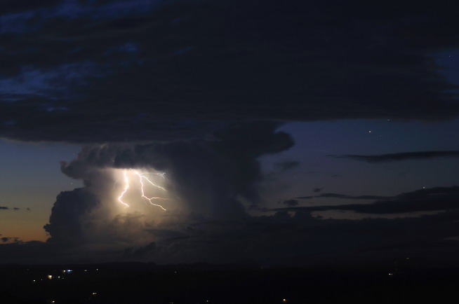
Friday night (22nd April) I took some shots of an isolated storm which was about 100ks NW of here


cheers, Michael
Location: Mcleans Ridges, NSW Northern Rivers
Australian Severe Weather:   http://australiasevereweather.com/
Lightning Photography:   http://www.lightningphotography.com/
Early Warning Network: http://www.ewn.com.au
Contact: Michael Bath