Author Topic: Hailstorm : NSW Storms (incl Sydney hailstorm): 7 to 9th December 2007  (Read 148944 times)

0 Members and 1 Guest are viewing this topic.

Offline Carlos E

  • Elephant Trunk F2
  • *
  • Posts: 135
  • Gender: Male
RE: Hailstorm : NSW Storms (incl Sydney hailstorm): 7 to 9th December 2007
« Reply #45 on: 11 December 2007, 07:04:19 AM »
Excellent photos/videos everyone. It's amazing the way these storms build up on the radar.

Offline Mike

  • Australian Severe Weather Moderators
  • Wedge tornado F5
  • *
  • Posts: 1,348
  • Gender: Male
  • Dry season here...boring!
    • http://StormscapesDarwin.com
RE: Hailstorm : NSW Storms (incl Sydney hailstorm): 7 to 9th December 2007
« Reply #46 on: 11 December 2007, 07:20:07 AM »
Impressive radar loop Michael.  Secondary storm was huge.  Sounding not too shabby either given the amount of shear in the levels!  Wow factor.  Structure on some of those posted photographs is very impressive, rotation galore.  Informative comments by everyone which makes for an interesting read as the thread continues!

Mike
Darwin, Northern Territory.
StormscapesDarwin.com
Lightning Research 2010/14

Offline pingtang

  • Multi-vortex F1
  • *
  • Posts: 70
  • Gender: Male
    • Southcoastweather
RE: Hailstorm : NSW Storms (incl Sydney hailstorm): 7 to 9th December 2007
« Reply #47 on: 11 December 2007, 10:44:21 AM »
I chased to Dubbo on Saturday but came away with nothing.Distant storms could be seen to the northeast towards Tamworth,but they wernt worth bothering about.Stayed in Mudgee overnight hoping the cap would break,but it didnt. Woke up to some rumbles on Sunday,BIG mistake of the day was not checking the models in Mudgee(too lazy to look for an internet cafe). I wont make that mistake again.So for that reason I thought Bathurst was a good target area to start with.We hung around Bathurst for a good while.  DPs held in the mid teens in Bathurst but something didnt seem right. A quick check of the Goulburn dewpoint got me moving eastwards to the Sydney Basin. Unfortunately when we got to Lithgow a storm developed to the east,and this exploded to become the supercell that ripped through Sydney.

Anyway heres the Sydney supercell looking from a blue mountains perspective(between Springwood and Katoomba at 3:50pm). Sorry about the serious lack of quality,I should have pulled over and taken a proper pic(we were in a mad rush to move east)


We saw alot of leaf litter on the pennant hills road.We also got onto some weakening storms near Gosford,but we only saw some CGs and light/moderate rain. A frustrating day but some lessons learnt.

Offline Mike

  • Australian Severe Weather Moderators
  • Wedge tornado F5
  • *
  • Posts: 1,348
  • Gender: Male
  • Dry season here...boring!
    • http://StormscapesDarwin.com
RE: Hailstorm : NSW Storms (incl Sydney hailstorm): 7 to 9th December 2007
« Reply #48 on: 11 December 2007, 10:47:50 AM »
Don't worry about the quality issues - it's what we can see what's important!

Mike
Darwin, Northern Territory.
StormscapesDarwin.com
Lightning Research 2010/14

Offline David C

  • Global Moderator
  • Barrel tornado F4
  • *
  • Posts: 643
  • Gender: Male
    • Thunderbolt Tours Storm Chasing Adventures
RE: Hailstorm : NSW Storms (incl Sydney hailstorm): 7 to 9th December 2007
« Reply #49 on: 11 December 2007, 12:00:07 PM »
Anyway heres the Sydney supercell looking from a blue mountains perspective(between Springwood and Katoomba at 3:50pm). Sorry about the serious lack of quality,I should have pulled over and taken a proper pic(we were in a mad rush to move east)


We saw alot of leaf litter on the pennant hills road.We also got onto some weakening storms near Gosford,but we only saw some CGs and light/moderate rain. A frustrating day but some lessons learnt.

That is a brilliant pic Pingtang in showing a different perspective of the storm! In addition to any forecasting lessons/clues that you and others may have learnt in going out bush over this particular period (eg forget about CAPE when there is any evidence of mid-level warming as was the case on several of the touted big days out there), it is always important to know when to give up when trying to play catchup. Had you found yourself a lookout and shot some photos / time-lapse of what we see in that picture above, well, you would have some exceptional storm footage. Of course, overcoming the lure of a storm is easier said than done.

Jimmy, Geoff and I tried, in vain, to get ahead of the Muswellbrook supercell a few years back. We had shot enough footage already and the storm was becoming HP, though, being chasers, we still wanted to get ahead. In the end, some of the largest hailstones - record breakers in Australia no doubt, were waiting to be picked up and documented - we gave it all up for a hopes of seeing the HP forward flank even though in reality we all knew we would not get ahead of that storm. The stuff we did get -- 8cm -- was the small stuff - the big stuff would have been 12cm+ -it was huge.
Storm Chaser,
Thunderbolt Tours - USA & Australia Storm Chase Tours
www.thunderbolttours.com

Jeff Brislane

  • Guest
RE: Hailstorm : NSW Storms (incl Sydney hailstorm): 7 to 9th December 2007
« Reply #50 on: 11 December 2007, 12:37:05 PM »
Dave,

do you know what the CAPE value was according to that sounding you posted? It looks big and i'd say 3500+-? Any ideas?

I agree with Dave about making the most of oppurtunity's. Timelapse foot of the back of the supercell with overshoots going up and even persisting would be very valuable. I know myself that once I got to Blacktown it was all over as far as chasing went. I could have kept going but it would've meant passing up the oppurtunity to document the hail size which turned out to be 8cm. I knew that others would document it's later stages and i'd done enough and gotten more than enough excitment and it's annoying chasing through city's and constanly copping traffic lights.

Jeff.

Michael Thomas

  • Guest
RE: Hailstorm : NSW Storms (incl Sydney hailstorm): 7 to 9th December 2007
« Reply #51 on: 11 December 2007, 01:36:21 PM »
Unfortunately I did not take any pictures yesterday as I was doing the Wollongong weather observations at the time, how's that for irony. Anyway, at 3pm I could see the storms to the north. At this stage they were obviously multicell with multiple updrafts going up one after the other. By around 3:30 that had quickly changed and there was one powerful updraft and a large backshearing anvil. This could be seen for quite some time and interestingly I could still see the updraft from Wollongong when the storm was at its most intense.

This storm was really quite amazing, my jaw alost hit the ground when I saw the radar when I got home. I think that is one of the most textbook radar signitures I have seen for sometime. Its quite good the BoM did the afternoon sounding, just one question though, do you think plotting for 32 degrees is appropriate. A LI of -11 is extreme to say the least, temps were around the mid to high twenties which may mean the LI was a little lower?

Michael

Offline David C

  • Global Moderator
  • Barrel tornado F4
  • *
  • Posts: 643
  • Gender: Male
    • Thunderbolt Tours Storm Chasing Adventures
RE: Hailstorm : NSW Storms (incl Sydney hailstorm): 7 to 9th December 2007
« Reply #52 on: 11 December 2007, 02:05:06 PM »
Dave,

do you know what the CAPE value was according to that sounding you posted? It looks big and i'd say 3500+-? Any ideas?

Jeff.

Hi Jeff, I know there are some programs going around that could be used to calculate CAPE (in all its forms) from the BoM soundings  (digital atmosphere etc)...but these seem to be tied up with the standard times.....and I don't use them myself. Or you could estimate it more manually; http://tornado.sfsu.edu/geosciences/classes/m201/buoyancy/CAPE_Procedure.html

or 

use the GFS forecast sounding on Brisbane Storm Chasing, compare the it to reality, as in yesterday's BoM sounding, and if ok plug in your dewpoint temperature values and re-plot to find calculated CAPE
http://soundings.bsch.au.com/skew-t.html?source=ncep&lat=-33.8607&lon=151.2050&date=2007120906&gribdate=2007120906

eg using Richmond obs 31 / 23

I'd agree with you though, just eyeballing it from previous experience, that it would be in the 3,500 - 4,000 range.

Temps were in the low 30's across some western suburbs around 2/3pm yesterday Michael (eg 30.5 Bankstown, 31.1 Richmond), so I'd assume, give or take within the usual error bars, that the Li would have been around -10 or -11 in the pre-storm environment....not too far off that mark anyway.
Storm Chaser,
Thunderbolt Tours - USA & Australia Storm Chase Tours
www.thunderbolttours.com

Offline David C

  • Global Moderator
  • Barrel tornado F4
  • *
  • Posts: 643
  • Gender: Male
    • Thunderbolt Tours Storm Chasing Adventures
RE: Hailstorm : NSW Storms (incl Sydney hailstorm): 7 to 9th December 2007
« Reply #53 on: 11 December 2007, 02:12:51 PM »
CAPE = ~ 4,500J/kg...so 3,500 +/1 1000 looks reasonable to me! although I'm thinking the BoM sounding was contaminated by the initial storm development. Any thoughts?

edit: actually, looking at radar, probably not!
« Last Edit: 11 December 2007, 05:11:01 PM by David C »
Storm Chaser,
Thunderbolt Tours - USA & Australia Storm Chase Tours
www.thunderbolttours.com

Offline Michael Thompson

  • Multi-vortex F1
  • *
  • Posts: 57
RE: Hailstorm : NSW Storms (incl Sydney hailstorm): 7 to 9th December 2007
« Reply #54 on: 11 December 2007, 03:50:35 PM »
Chase Report - Coonamble Area, 8th December 2006

There was a lot of expectation about this day - the GFS model had been predicting high CAPE values in the Central West and North West, every model also had a prominent warm layer from about 700mb to 500mb. I arrived at Dubbo at 1.30pm, at this stage there was Cu everywhere, but nothing at the congestus stage, except far NE over the Coonabarabran area.

I measured a surface temperature of 34C, and  dewpoint around 20C, whilst not exactly equating to low LCL's, under normal circumstances these conditions would be welcomed for an Aussi chaser. However the sky had me worried. I have been around long enough to know what a strong CAP looks like. I hit Dubbo library and ran a forecast sounding, my heart sank, the CAP from hell.

I hit the road again as Dubbo just did not look good. I headed northwards as the Cu looked more healthy, whilst still being on the plains.

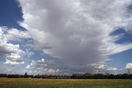
Finally around 4pm a small cell developed near Gulargumbone.  It did not look that impressive. But................................


...............a weak, but at the same time telling anvil told me that the updraft to this storm was obscured and probably stronger than it appeared.


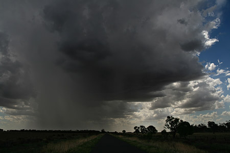
I headed further towards the cell. Some isolated CG's started coming down with the rain shaft. I saw one CG hit the ground about 100m away. The next minute I was enveloped in a nice microburst, I was unprepared and quickly fumbled for the camera.

A short video of a small microburst

I had high hopes after this. Was the CAP finally broken !  Alas the CAP held firm and in fact over the next hour seemed to be stronger.  There was another weak cell NE so I chased this to Baradine, but in the 80kms of road I could not catch it - there was obvious mid level steering wind taking the storms east.

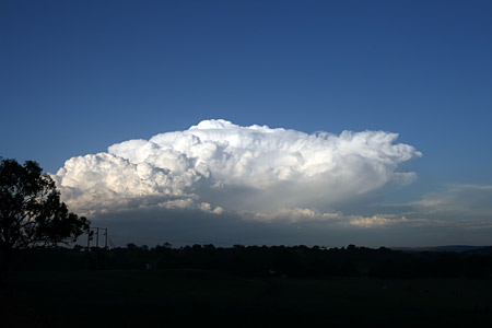
At Coonabarabran near sunset another storm developed to the NE - the picture clearly shows the low level glaciation and very low storm tops


I caught this cell near Gunnedah - by then however the show was largely over with lightning only once every 1 minute or so. So I headed home, arriving back in Wollongong after a 1480km round trip at 3.30am.

Lesson Learnt
In Australia over the last few years we have only infrequently seen the high CAPE levels that have been almost routine the past week or two - higher CAPE does not equal bigger storms, I knew this and I knew that there was a rather warm mid levels in play, but there was further hints in the models that should have picked up - why at 09Z, 12Z and 15Z was the CAPE still so strong?  perhaps because there were no storms to dissipate the energy !  Elementary in hindsight.


Offline vrondes

  • Multi-vortex F1
  • *
  • Posts: 77
RE: Hailstorm : NSW Storms (incl Sydney hailstorm): 7 to 9th December 2007
« Reply #55 on: 11 December 2007, 04:11:56 PM »
Sunday the 9th of December and Westpoint Blacktown at 3 pm, the only sound around was tenpins going down at a children's birthday we were invited to.  30 minutes later and it was hailing up to 4 cms  as pandemonium hit the shopping centre. Rushing outside to be greeted by hailstones that increased in size and shape up to the largest one I collected which I measured to be 7.8 cms. Accompanying  the largest ones was the return of  sunshine as the storm headed off to  the Hills- Glenhaven area. Making sure the kids were safe and sound I then photographed the hail shaft as it motored through Hornsby up to the central coast. Souvenir stones were kept and the largest is still  over 7.4 cms.  As Jeff mentioned the shapes were quite varied  from conglomerate pea cluster stones to a pearl centre stone surrounded by a large opaque shell. Reports, photos and video footage from all have been very knowledgeable. We now join the queue in claiming insurance on our battered and windscreen fractured car. Cheers, Con.

Offline Richary

  • Barrel tornado F4
  • *
  • Posts: 680
  • Gender: Male
RE: Hailstorm : NSW Storms (incl Sydney hailstorm): 7 to 9th December 2007
« Reply #56 on: 11 December 2007, 05:35:51 PM »
As mentioned I was lucky here at Rydalmere from a damage point of view, though unlucky from a storm chasing point of view. My boss lives near Castle Hill, his place had large tree branches down all through the yard and in the pool. When the power came back and pump for the solar hot water came on water started coming off the roof, it had trashed that but amazingly spared the windows.

The video on 9 news tonight was amazing of the tennis ball size hail and the holes it left in the lawn, people were putting the hail back in the holes to show how big they were.

I guess seeing as this is only a rented place if I get one of those here, at least I won't have to pay to fix it :-)

DLee

  • Guest
RE: Hailstorm : NSW Storms (incl Sydney hailstorm): 7 to 9th December 2007
« Reply #57 on: 11 December 2007, 06:30:25 PM »
Hello I am totally new here, but not new to weather.  I love clouds especially.

Unfortunately I was in the mall at Blacktown when the storm hit and couldn't find the exit so I could check out the storm when it hit :(, but I was with the crowd of shoppers looking at the large hailstones hitting the glass ceiling.  The noise was ridiculous!  A siren went off and there was jokes about a tornado warning. :D

We finally got outside and as we were driving along people were jumping out of their cars to get a more tangible view of the huge hailstones.  It looked amazing.


I went to a nearby field and was blown away by the size of them all.


A friend's windscreen was smashed in and my grandmothers porch roof has some interesting large dints in it!!!!

Thanks sooo much for all your posts and pics on here hay!  just awesome! :o

Offline Mike

  • Australian Severe Weather Moderators
  • Wedge tornado F5
  • *
  • Posts: 1,348
  • Gender: Male
  • Dry season here...boring!
    • http://StormscapesDarwin.com
RE: Hailstorm : NSW Storms (incl Sydney hailstorm): 7 to 9th December 2007
« Reply #58 on: 12 December 2007, 05:09:47 AM »
Welcome D Lee.  Your first post!!  A great start and we all look forward to further photos and comments from you.  We as members like to include cloud structures/photos so if you manage to get some beafy storm structures or anything photogenic we'd love to see them.

Hail looking more like rocks!  Hope your car did not sustain too much denting and could imagine the noise, would have been deafening on an iron roof.  I've never seen hail larger than 1.5cm so you can imagine my excitment and astoundment at some of the photos being posted also.

Mike
Darwin, Northern Territory.
StormscapesDarwin.com
Lightning Research 2010/14

Offline Michael Bath

  • storm chaser
  • Administrator
  • Wedge tornado F5
  • *
  • Posts: 1,602
  • Gender: Male
    • Australian Severe Weather
RE: Hailstorm : NSW Storms (incl Sydney hailstorm): 7 to 9th December 2007
« Reply #59 on: 12 December 2007, 05:55:05 AM »
Chase report NSW Northwest Slopes and Plains: Sunday 9th December 2007

A lot of cloud developed overnight and the storm targets in this northern part of NSW were pretty much a line from west of Narrabri to Goondiwindi. There was a lovely fresh NNE wind blowing.

Rodney and I headed to Moree. We stopped here for lunch and managed to check the sounding which showed more instability than the day before, but a lack of mid level winds and a little too much moisture. Cumulus was widespread but shallow throughout the late morning and early afternoon. We could see the congestus struggling to get through the cap - evident on the sounding around 800 hPa.

From about 3.30pm storms were beginning to form.


Quite a strong storm developed east of Collarenebri and was tracking generally NE towards Mungindi and Boomi so we headed west from Boggabilla.


We observed the storm from just west of Boomi. Two main updrafts were in play and both were spitting out plenty of CGs. The northern one dominated and tried to get its act together.


Another storm was developing overhead, and although it mucked up the earlier target, it ending up providing the best show of the day. A massive rain free area formed just to our north just before the CGs went ballistic.


We raced east to get into a better view and were treated to a brilliant display of lightning, with some very close bolts. The storm also developed a gustfront towards the north.


Video stills:


Other activity persisted into the evening but it became difficult with light anvil rain about and outflow winds from other cells. During the drive east to Tenterfield we were treated to ongoing lightning with many massive anvil crawlers. There had been a lot of rain from these storms in some areas: we hit a flooded floodway at full speed - that was a ride and a half !

---> All photos for 9th December

MB
Location: Mcleans Ridges, NSW Northern Rivers
Australian Severe Weather:   http://australiasevereweather.com/
Lightning Photography:   http://www.lightningphotography.com/
Early Warning Network: http://www.ewn.com.au
Contact: Michael Bath