Author Topic: VIC/NSW/QLD Storms 29 Oct - 2 Nov 2009  (Read 11050 times)

0 Members and 1 Guest are viewing this topic.

Offline Michael Bath

  • storm chaser
  • Administrator
  • Wedge tornado F5
  • *
  • Posts: 1,602
  • Gender: Male
    • Australian Severe Weather
VIC/NSW/QLD Storms 29 Oct - 2 Nov 2009
« on: 30 October 2009, 01:24:18 AM »
The next several days including today will see fairly widespread thunderstorm activity. The high in the Tasman continues to direct a lot of moisture over the inland.   The shear is pretty ordinary over most parts though more interesting over West VIC tomorrow (30th)
Location: Mcleans Ridges, NSW Northern Rivers
Australian Severe Weather:   http://australiasevereweather.com/
Lightning Photography:   http://www.lightningphotography.com/
Early Warning Network: http://www.ewn.com.au
Contact: Michael Bath

Offline Peter J

  • Stove pipe F3
  • *
  • Posts: 419
  • Gender: Male
  • Lets go get em boys!
RE: VIC/NSW/QLD Storms 29 Oct - 2 Nov 2009
« Reply #1 on: 30 October 2009, 03:15:18 PM »
There were some nice storms that developed to the east and north east of Melbourne... One storm in particular dumped 12.6mm in Montrose inside 20mins at about 3.30pm this afternoon - I was lucky to be witness to a vivid CG strike in Chirnside Park about the same time this afternoon - the resulting thunderclap was VERY loud...

Big Pete
(excited!)
PJJ

Offline Kristy Norman

  • Elephant Trunk F2
  • *
  • Posts: 120
  • Gender: Female
RE: VIC/NSW/QLD Storms 29 Oct - 2 Nov 2009
« Reply #2 on: 31 October 2009, 08:36:01 AM »
Some fantastic convection happening in our region, nice crispy towers. Things seem to have really kicked off in the last half hour with two decent storms developing to our west and distant rumbles. The air feels so humid and sticky.
Photo taken at 5pm looking north.
« Last Edit: 31 October 2009, 11:03:27 AM by Kristy Norman »

Offline Harley Pearman

  • Barrel tornado F4
  • *
  • Posts: 584
RE: VIC/NSW/QLD Storms 29 Oct - 2 Nov 2009
« Reply #3 on: 31 October 2009, 02:31:25 PM »
Rutherglen thunderstorm (North East Victoria) 30/10/2009

A very intense but relatively localised thunderstorm has hit the small town of Rutherglen in North East Victoria between 6.10 pm and 7 pm.

The Rutherglen Rise - Rutherglen Research Centre - Station number 82039 - Latitude 36.1 degrees south and 146.51 degrees east has captured it well (Details taken from its database via Bureau of Meteorology site).

6.10 pm 4 mm of rain.
6.21 pm 17 mm of rain (13 mm in 11 minutes).
6.24 pm 22 mm of rain (5 mm in 3 minutes).
6.30 pm 28 mm of rain (6 mm in 6 minutes).
7.00 pm 34.4 mm (Another 6.4 mm).

The weather station to 7.30 pm shows 34.6 mm of rain for the hour. Peak rainfall intensity occurred between 6.21 pm and 6.24 pm of 100 mm/hour with the main bulk of the storm occurring between 6 pm and just after 6.30 pm. In addition, the weather station shows a peak wind gust to 65 km/h from the North North West at 6.10 pm.

It would be interesting to find out what has happened in this area following this event as this looks like a strong storm in a localised area.

Harley Pearman

Offline vrondes

  • Multi-vortex F1
  • *
  • Posts: 77
RE: VIC/NSW/QLD Storms 29 Oct - 2 Nov 2009
« Reply #4 on: 31 October 2009, 04:01:29 PM »
An urban chill-out drive to the Wentworth Falls area found these two decaying storm cells this afternoon around 5pm. The first one to the north of Wentworth Falls, the second storm over the Mittagong area taken from Leura . Cheers, Con.


Offline Peter J

  • Stove pipe F3
  • *
  • Posts: 419
  • Gender: Male
  • Lets go get em boys!
RE: VIC/NSW/QLD Storms 29 Oct - 2 Nov 2009
« Reply #5 on: 01 November 2009, 12:36:01 PM »
This has been just added- courtesy BoM Melbourne:

IDV65752


Australian Government Bureau of Meteorology
Victoria Regional Office

TOP PRIORITY FOR IMMEDIATE BROADCAST


SEVERE THUNDERSTORM WARNING - MELBOURNE AREA
for DAMAGING WIND, FLASH FLOODING and LARGE HAILSTONES
For people in the
Geelong and Bellarine Peninsula and parts of the
Mornington Peninsula and
Port Phillip Local Warning Areas.


Issued at 6:11 pm Saturday, 31 October 2009.


The Bureau of Meteorology warns that, at 6:10 pm, severe thunderstorms were detected on weather radar near Moorabool. These thunderstorms are moving towards the southeast. They are forecast to affect Geelong City, northern parts of the Bellarine Peninsula and waters off Geelong City by 6:40 pm and Portsea, Queenscliff and waters off Queenscliff by 7:10 pm.


Damaging winds, very heavy rainfall, flash flooding and large hailstones are likely.


The State Emergency Service advises that people should:
* Keep clear of fallen power lines.
* secure any loose objects in the vicinity of your home.
* keep away from creeks and drains.
* do not drive vehicles through flooded areas.
* stay indoors if possible.
* Avoid using the phone during the storm.
* if you are outside, avoid sheltering under trees
* listen to the radio for storm updates
* switch off your computer and electrical appliances


The next warning is due to be issued by 7:10 pm.


A more general severe thunderstorm warning is also current for the East Gippsland, West and South Gippsland, Central, Alpine and parts of the Northeast, North Central and Western districts.

PJJ

Offline Peter J

  • Stove pipe F3
  • *
  • Posts: 419
  • Gender: Male
  • Lets go get em boys!
RE: VIC/NSW/QLD Storms 29 Oct - 2 Nov 2009
« Reply #6 on: 01 November 2009, 12:41:34 PM »
according to the map given by BoM, the cell is around Laverton area heading towards the bay then into Mornington area. The sat-rad has very dark shadows inside  red patch of this storm, and a weak tiny "hook echo" could be seen with the 6.20pm frame.

Big Pete
(PS it is highly possible for this to be a small supercell, but it is not in my visual range... also ast nite got woken at 1am by powerful storm whisking through lilydale) - 20mm in home gauge in 3hrs.
PJJ

Offline Dave Nelson

  • Elephant Trunk F2
  • *
  • Posts: 172
  • Gender: Male
    • Stormy Sydney
RE: VIC/NSW/QLD Storms 29 Oct - 2 Nov 2009
« Reply #7 on: 02 November 2009, 04:15:56 AM »
Hi Gang,
               gosh havent logged in for ages,

   Cindy and I are going to target the southern highlands to canberra region today and maybe capture some
of these storms.  Canberra and Cooma saw some intense activity yesterday (31-10-09).   AVN is showing
reasonable conditions in the same area today.

cheers
Dave

Offline Michael Bath

  • storm chaser
  • Administrator
  • Wedge tornado F5
  • *
  • Posts: 1,602
  • Gender: Male
    • Australian Severe Weather
RE: VIC/NSW/QLD Storms 29 Oct - 2 Nov 2009
« Reply #8 on: 02 November 2009, 04:49:30 AM »
This radar loop is interesting. It shows two cells coming together at Cooma - where hail to 4cm diameter was reported just before 6pm 31/10

128km Radar Loop for Canberra, 02:00 31/10/2009 to 09:00 31/10/2009 UTC
Location: Mcleans Ridges, NSW Northern Rivers
Australian Severe Weather:   http://australiasevereweather.com/
Lightning Photography:   http://www.lightningphotography.com/
Early Warning Network: http://www.ewn.com.au
Contact: Michael Bath

Offline Brad Hannon

  • Thunderbolt Tours Group
  • Stove pipe F3
  • ******
  • Posts: 427
  • Gender: Male
  • Colorado Beast - 2nd June 2005
Re: VIC/NSW/QLD Storms 29 Oct - 2 Nov 2009
« Reply #9 on: 02 November 2009, 06:10:17 AM »
Hi all, have had two great nights in Melbourne with late arvo initiation leading to possible supercells on Fri night and impressive storms again last night after plenty of daytime heating.  Fridays cells reportedly brought with them hail to 3cm (that Melbourne has been starved of) as well as great rain totals for areas in the path.  I was a distant witness (20km) to a fantastic lightshow over the city that went well past midnight when I got one closer CG.  On Saturday I scored some great structure from Craigieburn on the northern side of the first cells as they moved east and later I scored some lightning and structure from the southern side near Werribee.

Here are shots from Friday:


more shots from Saturday to come later
hmmm June 2nd......

Offline Brad Hannon

  • Thunderbolt Tours Group
  • Stove pipe F3
  • ******
  • Posts: 427
  • Gender: Male
  • Colorado Beast - 2nd June 2005
Re: VIC/NSW/QLD Storms 29 Oct - 2 Nov 2009
« Reply #10 on: 03 November 2009, 11:03:35 AM »
Hi John, unfortunately I saw no hail and couldnt confirm supercells but certainly very powerful, very active and long lived so perhaps.

Here are my pics from the next day, Saturday:


Hoping for more action tonight!
hmmm June 2nd......

Offline Michael Bath

  • storm chaser
  • Administrator
  • Wedge tornado F5
  • *
  • Posts: 1,602
  • Gender: Male
    • Australian Severe Weather
Re: VIC/NSW/QLD Storms 29 Oct - 2 Nov 2009
« Reply #11 on: 03 November 2009, 03:44:27 PM »
A bit of action over the centre of the country too:

Quote
Biggest storm in years hits Uluru
Brett Dutschke, Monday November 2, 2009 - 20:47 EDT
Uluru was been hit by a severe thunderstorm for the second time this spring, one of the biggest storms this decade in the area.

The storm produced a massive amount of rain and potentially damaging winds.

More than 60mm of rain was dumped by the storm in a little over an hour on Monday afternoon, including 30mm in just 20 minutes. The 63mm recorded adds up to Uluru's highest daily rainfall in more than eight years.

This is unusually heavy rain considering the time of the year, when moisture in the atmosphere is not at its highest. It is so unusual that the Uluru site has not recorded a higher daily total in November 19 years of records.

With such a high rain rate it is no wonder that there were strong winds associated with the storm too. Gusts exceeded 90km/h at the beginning of the storm.

The storm came at the end of another hot day, hotter than 39 degrees for the third day running. This is the hottest start to November in 14 years.

Tuesday will be much cooler, with a maximum close to the early November average of 34.
Location: Mcleans Ridges, NSW Northern Rivers
Australian Severe Weather:   http://australiasevereweather.com/
Lightning Photography:   http://www.lightningphotography.com/
Early Warning Network: http://www.ewn.com.au
Contact: Michael Bath

Offline Richary

  • Barrel tornado F4
  • *
  • Posts: 680
  • Gender: Male
Re: VIC/NSW/QLD Storms 29 Oct - 2 Nov 2009
« Reply #12 on: 03 November 2009, 05:56:19 PM »
With the weather bureau/TV forecasts of storms in Sydney today and tomorrow for the last few days I had been checking the CAPE/LI info on bsch and basically thought that if we got anything it won't be worth worrying about. My prediction for today was Canberra or south which turned out to be correct - apart from a couple of localised storms that blew up over the western Blue Mountains. Prediction for tomorrow is Sydney will again miss out on anything good, and most action will be Hunter region and slightly north from the same info. Oh well, our turn will come hopefully.

Offline pingtang

  • Multi-vortex F1
  • *
  • Posts: 70
  • Gender: Male
    • Southcoastweather
Re: VIC/NSW/QLD Storms 29 Oct - 2 Nov 2009
« Reply #13 on: 04 November 2009, 02:59:38 PM »
We've just returned from a fun weekends chasing.

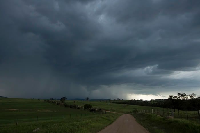
Chase report- Michalago, cooma Saturday 31st October   

We left Nowra at approximately 10:30am under partly cloudy skies. As we ventured up onto the Southern Highlands skies were clearer and temperatures were noticably warmer. As we took the Hume Hwy down to Goulburn we noticed the first signs of convection well to the distant Southwest probrably near the Snowy Mountains. We continued south to the town of Collector where I showed Lightning chaser an awesome view I found the previous day. At this stage it was 1:30pm, the convection was slowly buliding to the southwest. We decided to head south of Canberra as the skies looked terrible to the north of the ACT. Just south of Tuggeranong, the convection was becoming much healthier with some lovely updrafts to the southeast developing into a photogenic pulse storm. We pushed further south to the town of Michalago and watched this storm to our east. It had thunder every 10seconds or so,and even threw out the occasional clear air CG! Meanwhile a line of thunderstorms to our west got their act together with CGs becoming visable. We abandoned the eastern storm, and found a nearby hill which had a respectable view to the west. Unfortunately this lot of storms weakened however fresh bases developed just to our south.These bases rapidly became quite ominous and unleashed some very heavy precipitation cores! (see below)


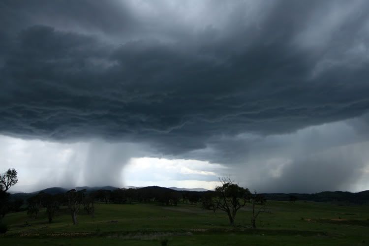
These bases were the Michalago storms which were picking up plenty of reds and even abit of black on radar. It became rapidly outflow dominant though, with the storm turning into large precip curtians though there was nice CGs at times.

With things looking rather dire in the Michalago area we decided to push south towards Cooma. While driving through Bredbo we caught glimpses of the strong Cooma pulse storm, with a very defined rain/hail curtain evident and even a guster. When we reached Cooma, the storm was still active with continous thunder however it was outflow dominated. As we got into the actual town outskirts of Cooma,we came across some fairly serious flash flooding. (see below)


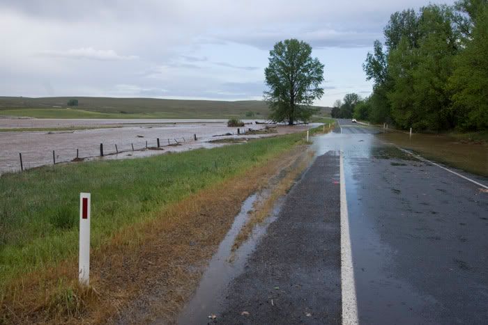
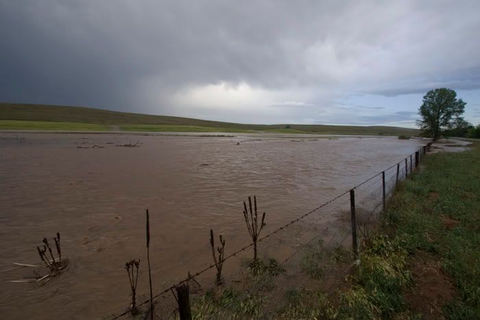
This water was flowing with large logs drifting past every now and then. The next day, there was no water in this area at all!!!

There was also plenty of hail,with some nice drifts evident on the sides of the road. One particular hill had turned white like snow. Some of these drifts were still evident at 9am this morning!!


Chase report- Bungendore area 1st November 2009   

We left Cooma after mid morning and orginally targeted the Michalago area. We found a neat little spot approx 5kms east of Michalago which had phone reception, shade,and best of all a nice view to the Southwest and West. We parked here for a good few hours or so keeping an eye on things. To kill some time we even set up a small putt putt course and played 18holes [Big Grin] During the afternoon we were becoming rather worried about the sky to our west. Cu and Cj was struggling big time and it didnt look like a cell could form anywhere west of the ranges. Meanwhile the convection to our east was MUCH healthier with a storm devloping 30kms to our SE in NO MANS LAND!. We then made the call to head north to Canberra where an east road option to Braidwood was available. On the way to Canberra we saw some very powerful convection. Some of the updrafts were explosive and easily the best i've seen since my QLD trip last year!

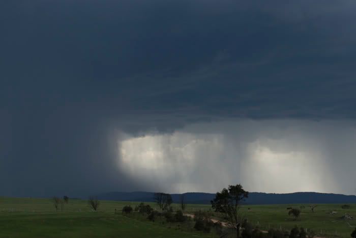
After what seemed ages we finally reached the town of Bungandore. From here two storms were evident about 30kms to the SSW. The northwestern storm was throwing out the occasional CA CG with nice distant booms following almost a minute afterwards. We found a great view just 20kms from Braidwood driving past two brown snakes on the way. The northeastern storm threw out numerous CGs(though distant), however it was gradually weakening. Meanwhile the northwestern storm was getting its act together with some nice rain free bases becoming apparant. We witnessed some nice pulsing CGs from these and heavy rain/hail shafts with some nice rain foots/ possible microbursts. (see below)


The main RFB slid to our north so we drifted northwestwards again to Bungandore in the hope of keeping ahead of it. We drove through a brief microcburst just before bungandore and also encountered heavy rain and minor flash flooding though I dont think we drove through the main core. We finally had a road option to the north, but we struggled to keep ahead of the anvil rain. The storm dished out one more lot of very nice CGs before weakening altogher. We then met up with Michael Thompson and Feral wx before calling it a day.


Offline Chris.

  • Multi-vortex F1
  • *
  • Posts: 52
  • Gender: Male
Re: VIC/NSW/QLD Storms 29 Oct - 2 Nov 2009
« Reply #14 on: 04 November 2009, 04:31:10 PM »
Warwick SE Qld, Sat 31.10.09 5.15pm

It is still very dry and we missed a lot of the much needed rain despite what looked ok up till the end of the month. We were lucky to get a few days last week. MB explained it and the storm in the inmage below collapsed in no time.  

Will look forward to November rain and bigger storms!