Author Topic: NSW, QLD & VIC Severe Storms : 27 - 31 Dec 2008 inlcuding classic supercell lightning hailstones  (Read 72982 times)

0 Members and 1 Guest are viewing this topic.

Offline James

  • Elephant Trunk F2
  • *
  • Posts: 149
  • Gender: Male
    • Sydney Storm Chasers
Considering the dynamics of an LP Supercell I would tend to agree it started off that way but seemed to change into a Classic Supercell whilst passing over Goonellabah/Richmond Hill. The RFD realy started to wrap around with precip/hail at this point.

This photo - http://www.australiasevereweather.com/photography/photos/2003/0212jd13.jpg - shows a similar base to the storm on the 30th of December. Lovely clear slot!

Dave Ellem has some great photos and time lapse video on his website here

Offline Jimmy Deguara

  • Australian and Tornado Alley storm chaser
  • Administrator
  • Wedge tornado F5
  • *
  • Posts: 2,218
  • Gender: Male
  • Storm Chaser since 1993, Tornado Alley 2001
    • Australia Severe Weather
Hi James,

Quote
Considering the dynamics of an LP Supercell I would tend to agree it started off that way but seemed to change into a Classic Supercell whilst passing over Goonellabah/Richmond Hill. The RFD realy started to wrap around with precip/hail at this point.

Personally I cannot comment because I was not there. However, none of the photographs and even the video with hail and a moderate rain falling convinces me of classic behaviour but perhaps it was tending that way around McLeans Ridges or further east. There is little run off in that video by Dave Ellem. The supercell is rather dry in all pictures taken.

Remember, an Low Precipitation supercell is defined as a supercell with little or no precipitation from the main updraft. LP supercells are notorious giant hail producers.

Any other pictures further east?

Regards,

Jimmy Deguara
-------------------------------------
Australian Severe Weather
www.australiasevereweather.com

Australian Thunderbolt Tours
www.thunderbolttours.com

Phone  0408 020468  (International :  61  2  408 020468)

Offline James

  • Elephant Trunk F2
  • *
  • Posts: 149
  • Gender: Male
    • Sydney Storm Chasers
My point was that your observations were quite right. It was LP status as per my understanding of LP, Classic and HP Supercells. Completely agree with you :)

As and just after the storm had passed through Mcleans Ridges is when it seemed to turn into a classic. Photo of it here looking NNE 15 or so minutes after passing


Offline Michael Bath

  • storm chaser
  • Administrator
  • Wedge tornado F5
  • *
  • Posts: 1,602
  • Gender: Male
    • Australian Severe Weather
Jimmy - there are numerous photos of the back of the storm further east like the one by James, but I have not come across any more from the N or NE before it passed out to sea.   Have a look at some more in the gallery here.  The meso passed over us just SW of Lismore with virtually no precipitation - just a few spits of rain. The road into Lismore did not look particularly wet with under 2mm at Lismore Airport and probably not much more in other parts of Lismore apart from eastern areas where the large hail fell.  12.5mm fell at my place. It does appear that the transition to classic occurred around this area.
Location: Mcleans Ridges, NSW Northern Rivers
Australian Severe Weather:   http://australiasevereweather.com/
Lightning Photography:   http://www.lightningphotography.com/
Early Warning Network: http://www.ewn.com.au
Contact: Michael Bath

Jeff Brislane

  • Guest
Jimmy,

I'm not talking about the hailstone in the womans hand but rather the hailstone in the mans hand with mud on it in the first image. Compare the stone to the width of the mans hand. My own hand is 9cm across the knuckles and if his is the same then that stone is at least 10cm and possibly a record for this season at least if not the area as it is wider than his handspan. The rest of the stones in his hand look to be around 7-8cm but that top one is a monster and must have left a significant crater!

To add to this post I've measured a friends hand and his is also 9cm across the knuckles.

Measuring from the base of my middle finger to the end of my palm gives me a measurment of 12cm. Looking at that mans hand which looks to be average size or larger than it's possible that the hailstone in question could have been as big as 12cm. I'm being very serious about this as I don't want to see a possible record hailstone size go un-noticed. Im my opinion it's as big at least as the largest stone you were hit by near Muswelbrook a few years back if not bigger.

Another interesting thing to notice is the average size of the stones collected in all images appears to be at least 6-7cm with a probable minimum of 5cm. The smallest stones are likely 5cm. So it stands to reason that if the average size is high then the maximum size must also be high.

Regards Jeff.
« Last Edit: 06 January 2009, 03:35:12 AM by Jeff Brislane »

Offline Jimmy Deguara

  • Australian and Tornado Alley storm chaser
  • Administrator
  • Wedge tornado F5
  • *
  • Posts: 2,218
  • Gender: Male
  • Storm Chaser since 1993, Tornado Alley 2001
    • Australia Severe Weather
Jeff,


Now you are seriously talking > 10cm  12cm hailstones are massive stones to be referring to! First - is it a man's hand or a boy's hand? What if the hailstone the woman was holding was the same one in that hand? Seriously, I would be very surprised if the storms on that day were on the scale to match what happened in Muswellbrook.

I have photographed my hand with callipers on opened at various measurements from 7cm through to 12cm in diameter.

7cm

8cm

9cm

10cm

11cm

12cm

Any further comments? Michael, are you able to determine whether it is a man holding the hailstones and whether they have any further images or have taken measurements. This one is killing me in suspense.

Regards,

Jimmy Deguara
« Last Edit: 12 January 2009, 05:29:15 AM by Michael Bath »
-------------------------------------
Australian Severe Weather
www.australiasevereweather.com

Australian Thunderbolt Tours
www.thunderbolttours.com

Phone  0408 020468  (International :  61  2  408 020468)

Offline Michael Thomas

  • Elephant Trunk F2
  • *
  • Posts: 172
  • Gender: Male
Good point regarding moisture depth Michael. I have had a closer look at the 12Z sounding and a few things have surprised me. First off, below 900mbar the air is very moist. This moist layer is then capped by what looks like an elevated mixed layer from roughly 900 to 800 mbar. Then from around 750 mbar and up the air is very dry. What I find interesting is that the possible elevated mixed layer between 900 to 800 mbar is actually unstable. In fact a parcel of air originating from between 900 to 800 mbar gives ~1200 j/kg of CAPE. It would appear that a small cap just below 700 mbar was all that was holding down this layer.

Regarding the storms structure, from what has been said I would have to a agree that initially the storm appears to have been LP but I am sure that a transition to a classic supercell would have occurred and I would guess to HP even when the storm moved offshore. The precipitation core of the storm was really quite small to the south of Lismore with quite low reflectivities. This is a good lesson I think, all to often people get excited about large blobs of black on the radar while this shows that quite large hail can fall from quite 'innocent looking' storms given the right conditions.

Michael

Offline Michael Bath

  • storm chaser
  • Administrator
  • Wedge tornado F5
  • *
  • Posts: 1,602
  • Gender: Male
    • Australian Severe Weather
Very unlikely to get any more detail about those hailstones given they were sourced from facebook by a friend of a friend of an email contact - lucky to see them at all I think.

It is very hard to estimate small and large hail sizes. To me the biggest look about 9cm but a proper ball shape of course. The hand holding the very big stone does look "youngish". My hand is about 1cm wider than yours Jimmy and I don't have big hands.   I'm certainly open to opinions on the size of those stones. Pity they didn't photograph them with something we know the size of.

Michael T - it was a lesson for me observing the 30th Dec Lismore supercell regarding precipitation - and lack of it SW of Lismore. It didn't completely click what was being observed at first. The updraft and meso was separated a long way from what radar was picking up as "the storm".   Be great to see the 3D scans of the structure.

Location: Mcleans Ridges, NSW Northern Rivers
Australian Severe Weather:   http://australiasevereweather.com/
Lightning Photography:   http://www.lightningphotography.com/
Early Warning Network: http://www.ewn.com.au
Contact: Michael Bath

Offline Mike

  • Australian Severe Weather Moderators
  • Wedge tornado F5
  • *
  • Posts: 1,348
  • Gender: Male
  • Dry season here...boring!
    • http://StormscapesDarwin.com
Are you talking about the TRMM images Michael?  Unfortunate we can't have the 3D look into these storms - would be highly beneficial.
Darwin, Northern Territory.
StormscapesDarwin.com
Lightning Research 2010/14

Offline Michael Bath

  • storm chaser
  • Administrator
  • Wedge tornado F5
  • *
  • Posts: 1,602
  • Gender: Male
    • Australian Severe Weather
These photos were taken by Greg Carlill from Pottsville on 30 Dec 2008. The first images were taken at 3.27pm local time and correspond to the radar image below the 2 photos.


This was taken at 3.43pm:


Mike - not TRMM - RHI I think they are called - gives a cross section through cells and can be obtained by asking the right BoM people.


Location: Mcleans Ridges, NSW Northern Rivers
Australian Severe Weather:   http://australiasevereweather.com/
Lightning Photography:   http://www.lightningphotography.com/
Early Warning Network: http://www.ewn.com.au
Contact: Michael Bath

Offline Mike

  • Australian Severe Weather Moderators
  • Wedge tornado F5
  • *
  • Posts: 1,348
  • Gender: Male
  • Dry season here...boring!
    • http://StormscapesDarwin.com
The structure of that storm in those images is amazing.  I've really got to make a trip one day during the next storm season and chase with one of you - stunning photos.  Thanks MB - will keep that in mind when I visit BoM.
Darwin, Northern Territory.
StormscapesDarwin.com
Lightning Research 2010/14

Offline David C

  • Global Moderator
  • Barrel tornado F4
  • *
  • Posts: 643
  • Gender: Male
    • Thunderbolt Tours Storm Chasing Adventures
Are you talking about the TRMM images Michael?  Unfortunate we can't have the 3D look into these storms - would be highly beneficial.

Be great to see the 3D scans of the structure.


I'm curious, what additional info would you guys expect vertical scans to reveal (excluding the obvious)? I can see that there is a decent vault visible when the storm was LP. (for anyone being initiated with the 'supercell spectrum' read Bluestein's paper on LP supercells. http://ams.allenpress.com/archive/1520-0493/111/10/pdf/i1520-0493-111-10-2034.pdf )

Regarding the Pilliga storm, I think Jeff may be right in that the sample of hail in the photos is very large and up there with the October 2004 Muswellbrook storm of 2004. Unless they have deliberately gone fossicking for the very largest stones (as perhaps only a storm chaser might do!), that is a pretty large mean hail size. Interestingly, I was out on a property very near to Gwabegar on the 20th Dec and they had two destructive hailstorms in the preceding months, including the one that trashed parts of Wee Waa.


Storm Chaser,
Thunderbolt Tours - USA & Australia Storm Chase Tours
www.thunderbolttours.com

Offline vrondes

  • Multi-vortex F1
  • *
  • Posts: 77
Excellent images and reports in this thread. We just got back from the hometown of Tamworth from holidays and have some photos  from the 29 th of December storms around Tamworth,
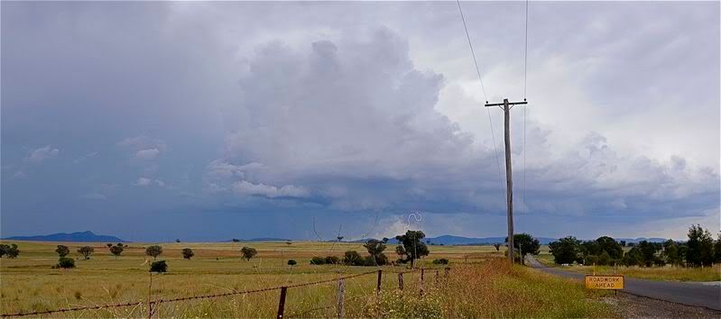
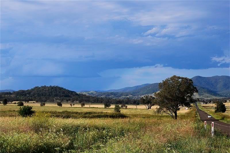
1st shot is looking south east towards the Great Dividing range of a departing storm half an hour before the main storm hit,


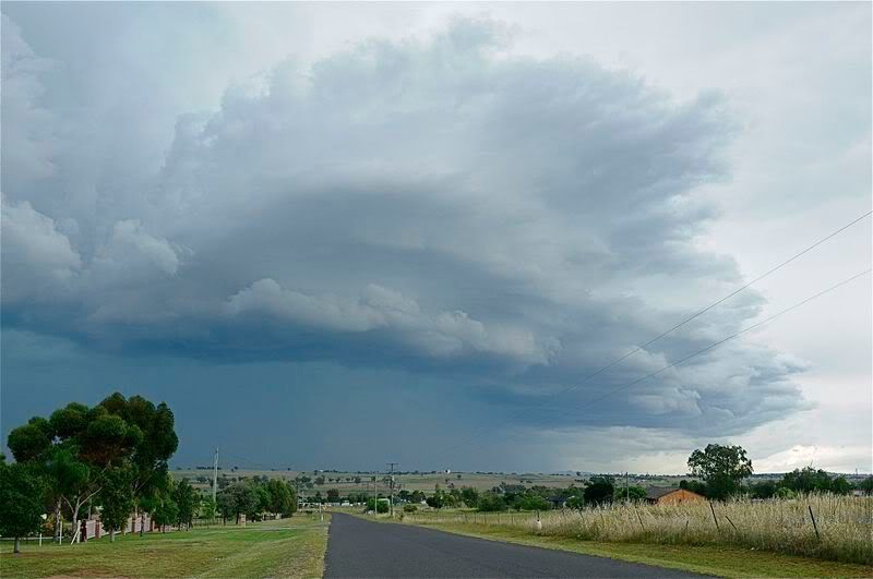
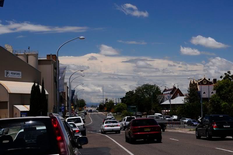
Main storm coming over the Melville ranges  that hit town with winds to 100kph recorded at the airport,


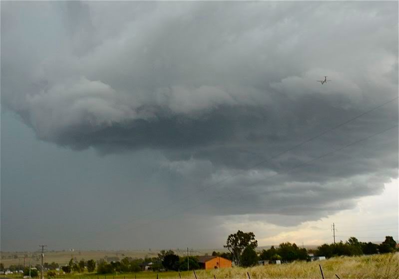
In the following shot you can see a Dash 8 coming in to land  at the airport as the front approaches.  Those who love turbulence would have enjoyed this landing,


This one of a developing LP cell to the north late in the day,


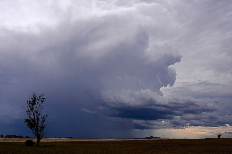
and finally the overshooting top of a storm to the east just after midday, possibly the Comboyne cell that produced 6cm hail as mentioned earlier in the thread


Cheers, Con.
« Last Edit: 10 January 2009, 03:35:59 PM by vrondes »

Offline Jimmy Deguara

  • Australian and Tornado Alley storm chaser
  • Administrator
  • Wedge tornado F5
  • *
  • Posts: 2,218
  • Gender: Male
  • Storm Chaser since 1993, Tornado Alley 2001
    • Australia Severe Weather
David,

Quote
Regarding the Pilliga storm, I think Jeff may be right in that the sample of hail in the photos is very large and up there with the October 2004 Muswellbrook storm of 2004. Unless they have deliberately gone fossicking for the very largest stones (as perhaps only a storm chaser might do!), that is a pretty large mean hail size.

Based on the ground coverage - rather limited and there does not seem to be much hail melt in the specific hailstones mentioned, I think they have fossicked around and found whatever they could find. To me they must have been in the most severe part of the storm - not as much precipitation and giant hailstones.

I go by my estimates that the environment on this day and the hail size was more of the 8 to 9cm maximum hail size - not the near 12cm being referred to here.

Regards,

Jimmy Deguara
-------------------------------------
Australian Severe Weather
www.australiasevereweather.com

Australian Thunderbolt Tours
www.thunderbolttours.com

Phone  0408 020468  (International :  61  2  408 020468)

Offline Michael Bath

  • storm chaser
  • Administrator
  • Wedge tornado F5
  • *
  • Posts: 1,602
  • Gender: Male
    • Australian Severe Weather


A follow-up regarding this event on 29th December 2008 (page 4 of this thread)

From the BoM's Lightning Bolt newsletter:

Quote
29 December 2008: At Edgeroi, north of Narrabri on the North West Plains, a supercell thunderstorm produced giant hail. Photo evidence showed hailstones to at least 11cm in diameter, some of the largest recorded in NSW.

Edgeroi is approx 100km NE of the hail photos sourced from Kenebri (if that's where they were actually taken).

VIS satpics and radar archives on the day are poor but it looks like it was not the same cell responsible for both of the large hail reports.


Location: Mcleans Ridges, NSW Northern Rivers
Australian Severe Weather:   http://australiasevereweather.com/
Lightning Photography:   http://www.lightningphotography.com/
Early Warning Network: http://www.ewn.com.au
Contact: Michael Bath