Author Topic: NSW, QLD & VIC Severe Storms : 27 - 31 Dec 2008 inlcuding classic supercell lightning hailstones  (Read 72985 times)

0 Members and 1 Guest are viewing this topic.

Offline Jimmy Deguara

  • Australian and Tornado Alley storm chaser
  • Administrator
  • Wedge tornado F5
  • *
  • Posts: 2,218
  • Gender: Male
  • Storm Chaser since 1993, Tornado Alley 2001
    • Australia Severe Weather
Hi guys,

First, James and Jason, awesome cell on the North Coast once again!

Monday 29 December 2008

Headed out with the expectations that anything to fire further south would have to do so by about early to mid afternoon. The storms were downhill from then. Unfortunately, the storms in the Hunter became too cluttered leaving. I had thought about targeting the lower Northern Tablelands and even the Mid North Coast but the traffic near the Bulahdelah area was incredible when I headed down a couple of days ago.

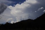
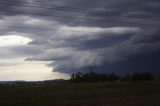
Taking some friends from the Central Coast, we headed to near Singleton. The storms formed a line but this did not deter me given the occasionally strong inflow as it approached. But the line weakened and the main storm near Cooranbong was impossible to get to. I thought about heading north to Quirindi but that would have meant another 4 or so hours to the trip. I'll await the outcome of David and Paul's efforts up that way.

Here are a few images:
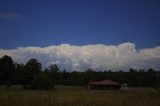
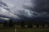


Right moving cell


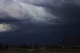
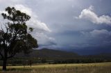
Cell approaching Muswellbrook later - after this cell we turned back home.


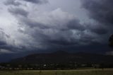
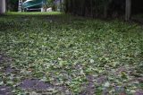
Aftermath damage of the Cooranbong cell which turned out to be very severe:

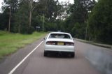
Not sure why this car had its back window smashed in! Perhaps a branch?


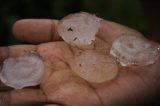
These hailstones were photographed 4 hours after the storm. Apparently the whole lawn was covered by hailstones up to the size of golf balls.


--->  All photos for 29 December 2008


Regards,

Jimmy Deguara
« Last Edit: 02 January 2009, 07:27:22 AM by Michael Bath »
-------------------------------------
Australian Severe Weather
www.australiasevereweather.com

Australian Thunderbolt Tours
www.thunderbolttours.com

Phone  0408 020468  (International :  61  2  408 020468)

indiie

  • Guest
Here is a gif of some footage I got shot from my balcony of a plane flying over the story bridge in Brisbane surrounded by lightning.

http://i41.tinypic.com/20k2b6g.gif

Later I'll be posting the footage on youtube with my other lighting vids here
http://au.youtube.com/view_play_list?p=654014151BB870F9

*Edit* here's the vid
http://au.youtube.com/watch?v=Prvry1EBUiY
« Last Edit: 02 January 2009, 07:28:08 AM by Michael Bath »

Offline Rodney Wallbridge

  • Multi-vortex F1
  • *
  • Posts: 71
  • Gender: Male
    • Red Bubble
Monday 29 December 2008

Gyday all, I grabbed a few shots of the squall line in SE QLD today.These pics were taken SE of Harrisville.  Awesome Piccies everyone that has posted!!!


« Last Edit: 02 January 2009, 07:29:46 AM by Michael Bath »

leo76

  • Guest
indiie - we saw plane fly over here late in the afternoon/early evening and it was flying rather low. We supsect it was to get under the storm.


indiie

  • Guest
indiie - we saw plane fly over here late in the afternoon/early evening and it was flying rather low. We supsect it was to get under the storm.

Yeah that one didn't appear to be on the usual flight path. It came from the direction of the airport so not sure but it may have even taken off during the storm, or otherwise may have been circling? It certainly changed it's path and started circling back over the city after the close call!

Offline Michael Bath

  • storm chaser
  • Administrator
  • Wedge tornado F5
  • *
  • Posts: 1,602
  • Gender: Male
    • Australian Severe Weather
NSW North West Slopes and Plains

I have just received an email reporting hail to 50mm and 20mm of rain just north of Edgeroi. I heard 3rd hand of a house and cars being 'destroyed' by hail the size of oranges near Terry Hie Hie. And ABC News are reporting that houses lost roofs and power lines were brought down in Boggabilla today. Tamworth Airport AWS recorded a 107km/h gust during the storm down there.

David - I have been sent photos of gorilla sized hail from Kenebri, SW of Narrabri. Some of the stones are bigger than cricket balls and completely solid - not discs or jagged shapes - HUGE !   Seeking permission to show them here.

Terrific photos everyone. I wasn't able to chase yesterday due to family commitments in Ballina but still got some photos from here and there.

Pity the radar archives have failed, along with some key missing 1km VIS images yesterday afternoon.

MB


Location: Mcleans Ridges, NSW Northern Rivers
Australian Severe Weather:   http://australiasevereweather.com/
Lightning Photography:   http://www.lightningphotography.com/
Early Warning Network: http://www.ewn.com.au
Contact: Michael Bath

Paul Graham

  • Guest
Monday 29 December 2008

Dave Croan and myself chased through the Hunter to the NW Slopes.  A line of convection in clear air over the Dharug Nat Park area north of Sydney appeared solid and crisp, but we decided to pursue our target zone near Scone since this was closer to a region of higher CAPE forecast by the GFS model.  Looking north, it was apparent that storms were not developing into the clean clear air available to their cousins in the south.  There was little to inhibit them and the sky was murky with anvils from storms billowing up all over the place.  Sadly, from a chaser's perspective, this was going to limit the energy available and lead to the demise of some as they ingested rain chilled air.

Collage of storm gusting out near Scone


Backend of supercell east of Scone (late in the afternoon)

« Last Edit: 02 January 2009, 07:31:57 AM by Michael Bath »

Offline Antonio (stormboy)

  • Stove pipe F3
  • *
  • Posts: 481
  • Gender: Male
We were coming home from Sydney yesterday (29 Dec 2008) to Ballina and at 2pm a severe storm with very strong winds, hail and flooding rain developed at Bulahdelah.

These are some pictures a movie will come soon showing what we came home to at 9pm
« Last Edit: 02 January 2009, 07:34:12 AM by Michael Bath »

Offline nzstorm

  • Elephant Trunk F2
  • *
  • Posts: 115
  • Gender: Male
Yes, great photos there. It strikes me this is a particularly active storm season over there.
Steven Williams
Storm Chaser

indiie

  • Guest
Yes, great photos there. It strikes me this is a particularly active storm season over there.

Nice pun ;). Yes I'd agree.. at least a half dozen lightning storms since last month.

indiie

  • Guest
A couple of screen caps from my vids taken last night (29 Dec). Not the best picture quality.

« Last Edit: 02 January 2009, 07:36:15 AM by Michael Bath »

Offline Harley Pearman

  • Barrel tornado F4
  • *
  • Posts: 584
First lightning photos from storm chase 27/12/2008

My first photos of lightning that I took from my storm chase near Canberra - Queanbeyan region 27/12/2008. I was located SW of Mt Jerrabomberra looking west. The photos were taken between 12 noon and 1 pm.

Harley Pearman

Offline David C

  • Global Moderator
  • Barrel tornado F4
  • *
  • Posts: 643
  • Gender: Male
    • Thunderbolt Tours Storm Chasing Adventures
I thought about heading north to Quirindi but that would have meant another 4 or so hours to the trip. I'll await the outcome of David and Paul's efforts up that way.

Adding to Paul's post above, storm spacing was a problem with the upper Hunter at the time when there was cooling aloft. This storm that developed west of Scone looked nice in it's incipient phase but was soon buggered up by cool downdraft air from another storm just to the east.


What was interesting was the low cloud bases and the interaction with the nearby hills. Have never seen a hill enveloped by a shelf cloud at such close range before!


As for the storm that tracked through Breeza and on to Tamworth, well we just went drove through the plains hoping to wash the car. Lot's of close Cgs, very heavy rain with some small hail and strong winds.


A good chase overall, particularly with Paul now being based in Melbourne and me not getting much spare time to chase atm.
Storm Chaser,
Thunderbolt Tours - USA & Australia Storm Chase Tours
www.thunderbolttours.com

indiie

  • Guest
Here's the full vid of the plane narrowly avoiding the lightning
http://au.youtube.com/watch?v=Prvry1EBUiY

Offline James

  • Elephant Trunk F2
  • *
  • Posts: 149
  • Gender: Male
    • Sydney Storm Chasers
Great photos Paul/David, some real nice structure in those shots. How close was the flang in the video capture? Looks pretty close!

Tues 30 December 2008

I was heading back from lunch at Alstonville when the storm first came into view today. What a sensational classic Supercell! The worst part - I didn't have my camera with me. I had chaser convergence with Dave Ellem so hoping he got some photos of the structure as it was up there with my top 5 in Australia. One of Becks photos (http://s387.photobucket.com/albums/oo317/stormy3972/30th%20Dec%2008/?action=view&current=Panorama4.jpg ) shows the curvature of the base and it really was rotating.

I headed home to get my camera and by that stage the hail was starting to fall. Started off as 2-3 cm stones before 4cm stones started falling sporadically around the grass. I headed up to Floreat Park and watched as stones as large as 6cm fell all around.


Had to head to Lismore for an hour however managed some photos of the back end structure which was huge. The updrafts were boiling up and backshearing against an 80 knot jetstream!


Heading back from Lismore the structure was still there and looking even bigger than earlier.


One of the hail nets over an hour after the storm had passed on Cowlong Road.

   
« Last Edit: 02 January 2009, 07:40:41 AM by Michael Bath »