Author Topic: VIC/NSW Rain, Floods and Storms 29 Oct - 2 Nov 2010  (Read 16399 times)

0 Members and 1 Guest are viewing this topic.

Offline supercell_impact

  • Rope Tornado F0
  • *
  • Posts: 4
  • Gender: Male
VIC/NSW Rain, Floods and Storms 29 Oct - 2 Nov 2010
« on: 28 October 2010, 02:16:58 PM »
This is looking good for falls of 50+ falls in Vic with the models indicating a low forming over northern Vic or south eastern sa. The rain band will approach western Vic into Friday evening and then over Vic satuday. This could renew flooding in the north east of the state.

Offline Michael Bath

  • storm chaser
  • Administrator
  • Wedge tornado F5
  • *
  • Posts: 1,602
  • Gender: Male
    • Australian Severe Weather
RE: VIC/NSW Rain, Floods and Storms 29 Oct - 2 Nov 2010
« Reply #1 on: 30 October 2010, 08:04:14 AM »
This event is shaping up to be a decent rain producer. There are flood watches out for most of VIC along with parts of SE NSW and N Tassie.

Location: Mcleans Ridges, NSW Northern Rivers
Australian Severe Weather:   http://australiasevereweather.com/
Lightning Photography:   http://www.lightningphotography.com/
Early Warning Network: http://www.ewn.com.au
Contact: Michael Bath

Offline Kristy Norman

  • Elephant Trunk F2
  • *
  • Posts: 120
  • Gender: Female
RE: VIC/NSW Rain, Floods and Storms 29 Oct - 2 Nov 2010
« Reply #2 on: 30 October 2010, 09:41:41 AM »
Hmmm....

I am really hoping we don't get as much rain as is forecast.

We have already lost four thousand acres of amazing crops to floods, most of which is still under waist deep water  :(

Not good.

Offline Harley Pearman

  • Barrel tornado F4
  • *
  • Posts: 584
RE: VIC/NSW Rain, Floods and Storms 29 Oct - 2 Nov 2010
« Reply #3 on: 30 October 2010, 12:52:18 PM »
Possible rainfall for 29 October to 1 November 2010

The Bureau of Meteorology "Land and Water Model" for the period 29 October to 1 November suggests rainfall of between 50 and 100 mm for north east Victoria especially for the Kiewa River valley, Mitta Mitta River valley, upper Murray River valley and the Ovens River valley including the highlands of Victoria. The model suggests that rainfall of 25 to 50 mm may occur in adjacent regions including southern New South Wales. The model also suggest that much of Victoria except the far east should receive from 25 to 50 mm during the period.

During the period of 24 and 25 October, I drove around North East Victoria including the Mitta Mitta Valley, Kiewa Valley and Ovens Valley which has suffered from recent flooding. The river catchments and the rivers are still sodden or swollen and roads are still cut such as the Kiewa Valley Highway at Dederang due to a bridge being washed away. Many repairs to roads and bridges have not been completed. I saw clear evidence of recent flooding along all three rivers I visited. This rain event should it eventuate does have potential to be problematic in this region especially along the river flood plains.

Water is being released from the Hume Reservoir and minor flooding may occur downstream from the dam wall along the Murray River. Further increased water releases are occurring from this dam in anticipation of a rain event this weekend across the region.

The rain plot from the Bureau of Meteorology Land and Water for the period 29 October to 1 November 2010 is provided below.

Harley Pearman

Offline Harley Pearman

  • Barrel tornado F4
  • *
  • Posts: 584
RE: VIC/NSW Rain, Floods and Storms 29 Oct - 2 Nov 2010
« Reply #4 on: 31 October 2010, 08:16:54 AM »
A satellite photo of southern Australia shows the entire state of Victoria blanketed by cloud. In addition, the entire western half of New South Wales is blanketed by the same cloud mass (Satellite photo attached from Weatherzone dated 30/10/2010). From 9 am to approximately 1.30 pm 30/10/2010, Swan Hill had recorded the highest rainfall of 21 mm but its still raining at that locality.

The area to watch is North East Victoria. Again rainfall totals are starting to accumulate in areas along the northern ranges with falls in the 10 to 20 mm range such as 17 mm at Mt Hotham and 15 mm near Jingellic. Albury Airport had recorded 3.4 mm before 9 am and another 8.8 mm from 9 am to 1.40 pm. There is a while to go before the cloud mass clears the through the state. It appears that this is going to be a major rain event in an area that is still recovering from the previous event only 2 weeks ago.


Harley Pearman

Offline Harley Pearman

  • Barrel tornado F4
  • *
  • Posts: 584
RE: VIC/NSW Rain, Floods and Storms 29 Oct - 2 Nov 2010
« Reply #5 on: 31 October 2010, 11:31:11 PM »
Overnight Rainfalls to 5 am 31/10/2010

Southern New South Wales and parts of Victoria including Melbourne have received some heavy overnight rainfalls from 9 am 30/10/2010 to 5 am 31/10/2010.

In particular weather stations around Melbourne have received rainfalls from 32 mm to 63 mm. Across North East Victoria, an isolated rainfall of 104 mm occurred at Dinner Plain followed by 69.4 mm at Falls Creek. Tallangatta had 62 mm during the period. Thredbo received 59.2 mm. Albury Airport on Borella Road 50.2 mm. There are smaller totals of 37.6 mm at Chiltern. Deniliquin, Shepparton and Wagga Wagga received 28 to 29 mm during the period.

A radar image from Weatherzone below taken at 8.30 pm 30/10/2010 is showing a narrow banding of heavy rainfall which had embedded thunderstorms within it crossing through north east Victoria and Southern New South Wales. These were training but were travelling from a north to south direction. It is this system that has caused much of the rainfall to occur over a small area between the period 7 pm to 11 pm. The system passed down through the Kiewa Valley to produce the larger and localised rainfall.


Harley Pearman

Offline Michael Bath

  • storm chaser
  • Administrator
  • Wedge tornado F5
  • *
  • Posts: 1,602
  • Gender: Male
    • Australian Severe Weather
Re: VIC/NSW Rain, Floods and Storms 29 Oct - 2 Nov 2010
« Reply #6 on: 02 November 2010, 06:34:47 AM »
Fairly long-lived supercell has just passed through Dungog and surrounds.

Quote
DETAILED SEVERE THUNDERSTORM WARNING
for DESTRUCTIVE WIND, LARGE HAILSTONES and FLASH FLOODING
For people in parts of the
Greater Newcastle area.


Issued at 12:34 pm Monday, 1 November 2010.


The Bureau of Meteorology warns that, at 12:35 pm, severe thunderstorms were detected on weather radar near the Dungog district, the Stroud district and Limeburners Creek. These thunderstorms are moving towards the southeast. They are forecast to affect Lemon Tree Passage, Karuah and Port Stephens by 1:05 pm and Nelson Bay, the Hawks Nest district and Broughton Island by 1:35 pm.

Destructive winds, large hailstones, very heavy rainfall and flash flooding are likely.

The latest radar data at time of issue indicates the thunderstorm cell between Dungog and Karuah is probably producing hail at least 5cm in diameter. This cell is moving towards the southeast and is likely to cross the coast at or near Nelson Bay.
Location: Mcleans Ridges, NSW Northern Rivers
Australian Severe Weather:   http://australiasevereweather.com/
Lightning Photography:   http://www.lightningphotography.com/
Early Warning Network: http://www.ewn.com.au
Contact: Michael Bath

Offline scottme

  • Multi-vortex F1
  • *
  • Posts: 37
  • Gender: Male
Re: VIC/NSW Rain, Floods and Storms 29 Oct - 2 Nov 2010
« Reply #7 on: 02 November 2010, 06:44:39 AM »
Has had a solid black core for at least 3/4 hour. Can't really see anything from Newcastle, just a dark gloom. Will probably punch holes in roofs etc. and allow the following HP cells to dump rain in  :(

As of 13:30, another probable supercell heading towards Taree / Foster from NNW.
« Last Edit: 02 November 2010, 07:33:39 AM by scottme »

Offline Michael Bath

  • storm chaser
  • Administrator
  • Wedge tornado F5
  • *
  • Posts: 1,602
  • Gender: Male
    • Australian Severe Weather
Re: VIC/NSW Rain, Floods and Storms 29 Oct - 2 Nov 2010
« Reply #8 on: 02 November 2010, 07:53:32 AM »
Jimmy and Nick are on the scene.


Harald Richter just posted this on AustpacWx List:

Quote
The radar image attached to Ken's email shows a hint of a downrange reflectivity extension
from the intense core NW of the Lemontree radar.  I have attached a more obvious
version of this hail spike (three-body scatter spike) which indicates to the astute warning
meteorologist that the hydrometeors within this storm are getting ... well, big.

The echo overhang to the E is also quite impressive.  The cross section is taken along
the turquoise line in the top image.

The storm is moving at about 20 kts from 300 degrees, which allows it to ingest a fair
amount of storm-relative helicity in the curved Newcastle hodograph.

Harald
Location: Mcleans Ridges, NSW Northern Rivers
Australian Severe Weather:   http://australiasevereweather.com/
Lightning Photography:   http://www.lightningphotography.com/
Early Warning Network: http://www.ewn.com.au
Contact: Michael Bath

Offline scottme

  • Multi-vortex F1
  • *
  • Posts: 37
  • Gender: Male
Re: VIC/NSW Rain, Floods and Storms 29 Oct - 2 Nov 2010
« Reply #9 on: 02 November 2010, 08:07:54 AM »
I'd hate to have car parked outside anywhere near Dungog. There is another probable supercell opened up there now.

It's really dark here in Newcastle.
« Last Edit: 02 November 2010, 08:21:42 AM by scottme »

Offline nmoir

  • Elephant Trunk F2
  • *
  • Posts: 200
  • Gender: Male
  • "busting chases since 1999"
    • Oculi.com.au
Re: VIC/NSW Rain, Floods and Storms 29 Oct - 2 Nov 2010
« Reply #10 on: 02 November 2010, 03:35:42 PM »
Jimmy and i had a go at the Dungog cell , poor roads , ample trees , low cloud and lots of hills made it  difficult to find a decent position , i have to say i was expecting larger hail than the 1-2cm hail we encountered south of Booral , i have no images of its structure , i think jimmy may post one. we were about 10km east of it when it went through Dungog.
we then went north up the pacific hwy to have a go at another cell west of taree but it weakened as we approached.
Nick Moir
Photographer
The Sydney Morning Herald
and www.oculi.com.au

Offline Jimmy Deguara

  • Australian and Tornado Alley storm chaser
  • Administrator
  • Wedge tornado F5
  • *
  • Posts: 2,218
  • Gender: Male
  • Storm Chaser since 1993, Tornado Alley 2001
    • Australia Severe Weather
Re: VIC/NSW Rain, Floods and Storms 29 Oct - 2 Nov 2010
« Reply #11 on: 02 November 2010, 04:26:35 PM »
Hi,

Just in response to Nick's post, here is all I could get between the mountains. There was a moisture haze as one would expect in a frontal boundary zone.


We also gave the Taree supercell a go but unless it came off the ranges, it was impossible to see any decent structure. It weakened dramatically.

I also found interesting that small black cored cell that may have been elevated and also deviated.

Regards,

Jimmy Deguara
-------------------------------------
Australian Severe Weather
www.australiasevereweather.com

Australian Thunderbolt Tours
www.thunderbolttours.com

Phone  0408 020468  (International :  61  2  408 020468)

Offline pingtang

  • Multi-vortex F1
  • *
  • Posts: 70
  • Gender: Male
    • Southcoastweather
Re: VIC/NSW Rain, Floods and Storms 29 Oct - 2 Nov 2010
« Reply #12 on: 03 November 2010, 06:04:05 AM »
Yesterday I had a successful but at times frustrating chase to Gloucester.

I checked the models at Taree library this morning (9:30am) and made the decision to head westwards. I found a good view 10kms west of Taree and sat there for 20minutes or so. I moved further westwards as I had the feeling the ranges would see the majority of action. Almost at Gloucester I got a phonecall from Lightning Chaser, he mentioned about the impressive storm over Dungog which was 50kms to my south. Unfortunately it was one of those days where you can't even make out a storm thats reasonably closeby.There was simply too much low cloud. I was dissapointed about missing out, but the air felt primed for more storms. I found a respectable vantage point 10kms east of Gloucester and waited.


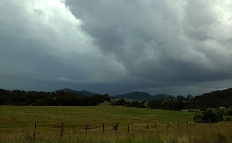
A storm came into view behind the hills,and a solid RFB began to show itself (below)


Unfortunately for me this base decided to stay put ,over no mans land( about 20kms to my north). Desparate to get closer I hunted around for roads that would take me closer to the storm. Unable to find a road I had to settle with distant glimpses of the structure including some lovely inflow features (see below) At this stage the anvil thunder was almost constant, but no CGs to be seen. Warm inflow was on my back, gusting up to 30km/h.


For a good hour or so the storm refused to move any closer and this became extremely frustrating. At times the structure had supercell appearances to it,but quite often the most interesting part of the storm was blocked behind hills.

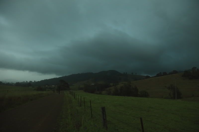
Eventually the storm moved into a useful range for me. Just after I took the photo below, some lovely CGs battered the country side just 3kms to my west. The booms were very loud and echoed off the surrounding mountains. A couple of CGs struck beside me about 1.5-2kms away,but there was no way I was getting in the car. Unfortunately the rain forced me into the car.CGs were still coming down reasonably close by, but the storm was outflow dominated and rapidly weakening, to such an extent that I only got moderate rainfall and 50km/h winds. I'm conviced large hail would've fallen at the storms peak.


Heres a 2 minute clip from yesterdays action.

Severe storm- Gloucester- November 1 2010

Offline Shane Watson

  • Rope Tornado F0
  • *
  • Posts: 5
  • Gender: Male
Re: VIC/NSW Rain, Floods and Storms 29 Oct - 2 Nov 2010
« Reply #13 on: 03 November 2010, 06:50:23 AM »
Hey fellas,

I managed to get out and about yesterday for a fun chase. Although was unable to properly position myself under any particular cell (Briefly was under the weakened phase on the stroud cell around 230pm). I must have been pretty close to Jimmy and co for a while. I shot SW from Buladelah over that mountain pass (Treachous with visibility down to a minimum I must say). I was very confused as why I didn't encounter larger hail (Only ~1cm maybe odd 1.5). So I mapped out the track of the cell on my phone and figured that Stroud must have had the worst of it, so I went to investigate (This is about 1 to 1.5hrs after the cell had gone through). These pics are what I found. I'd say there is ample evidence that hail was between 3-5cm in diameter (Although hard to make a precise judgement). I didn't observe any smashed windscreens or dents from afar but plenty of shredded trees and amazed residents at how much hail fell.

http://www.sydneyweatherblog.com/wp-content/uploads/2010/11/shredded_tree.jpg
http://www.sydneyweatherblog.com/wp-content/uploads/2010/11/hail1.jpg
http://www.sydneyweatherblog.com/wp-content/uploads/2010/11/hail_accumulation.jpg
http://www.sydneyweatherblog.com/wp-content/uploads/2010/11/hail.jpg

Shane

Offline Michael Thomas

  • Elephant Trunk F2
  • *
  • Posts: 172
  • Gender: Male
Re: VIC/NSW Rain, Floods and Storms 29 Oct - 2 Nov 2010
« Reply #14 on: 03 November 2010, 09:56:34 AM »
Shame about the bad terrain and low-level cloud. Pingtang, must of been annoying being so close but not being able to get right near the base, especially since it was near stationary. I would be suprised if there was some decent dumps of hail with that storm. Shane, thanks for the photos. Looks like it would have been pretty intense in Stroud!

Michael