Author Topic: NSW, QLD & VIC Severe Storms : 27 - 31 Dec 2008 inlcuding classic supercell lightning hailstones  (Read 72986 times)

0 Members and 2 Guests are viewing this topic.

Offline Kristy Norman

  • Elephant Trunk F2
  • *
  • Posts: 120
  • Gender: Female
Wow!!! Some really beautiful shots. There is nothing happening here so it's great to see you guys getting some amazing storms. Hope it continues well into the new year and beyond!

Offline Jimmy Deguara

  • Australian and Tornado Alley storm chaser
  • Administrator
  • Wedge tornado F5
  • *
  • Posts: 2,218
  • Gender: Male
  • Storm Chaser since 1993, Tornado Alley 2001
    • Australia Severe Weather
Hi guys,

I had posted something earlier but it seems to have gotten lost during a simultaneous post by someone else ( a good idea therefore to be very careful and any long posts do it in a text editor like notepad as a back-up).

The storms are amazing this year in your region. I particularly like the structured cow catcher nearer Byron Bay - that is when the storm seems very well mature and structured! Excellent stuff!

Regards,

Jimmy Deguara
« Last Edit: 02 January 2009, 04:02:35 AM by Jimmy Deguara »
-------------------------------------
Australian Severe Weather
www.australiasevereweather.com

Australian Thunderbolt Tours
www.thunderbolttours.com

Phone  0408 020468  (International :  61  2  408 020468)

Offline Michael Bath

  • storm chaser
  • Administrator
  • Wedge tornado F5
  • *
  • Posts: 1,602
  • Gender: Male
    • Australian Severe Weather
Here are the hailstones from Kenebri, NSW on Monday 29th December. The photographer did not request their name to be shown but has given permission for the shots to be displayed here.


Nice fingernails in the 2nd shot  :)

MB

Location: Mcleans Ridges, NSW Northern Rivers
Australian Severe Weather:   http://australiasevereweather.com/
Lightning Photography:   http://www.lightningphotography.com/
Early Warning Network: http://www.ewn.com.au
Contact: Michael Bath

Offline Antonio (stormboy)

  • Stove pipe F3
  • *
  • Posts: 481
  • Gender: Male
today they predict Increasing cloud with the chance of isolated afternoon showers and thunderstorms. Light northwest winds becoming moderate to fresh north to northeast along the coast in the afternoon and evening in the northern rivers . lets hope that some storms do come out of the blue today it will be a great start to the year.

HAPPY NEW YEAR ALL!

Offline Michael Bath

  • storm chaser
  • Administrator
  • Wedge tornado F5
  • *
  • Posts: 1,602
  • Gender: Male
    • Australian Severe Weather
Here's a few of my storm pics from some of the other dates in this thread.

Sunday 28th December 2008

A severe thunderstorm warning for flash flooding was issued shortly before the main cell of the afternoon developed right over my place at McLeans Ridges.

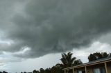
Some funnel like base features as the cell intensified on its northward heading.


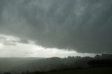
The rainfall was very intense with 34mm falling - most of which fell in about 10 minutes.  CGs went nuts for a while - the storm really punched upwards right here. Hail and about 50mm of rain was reported a few ks to my north at Clunes.
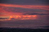


Nice sunset too.


All photos for 28 December 2008


Monday 29th December 2008

I wasn't able to chase due to family commitments in Ballina.

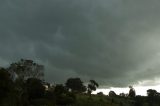
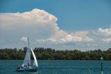
This is the early cell south of Grafton looking across the Richmond River.


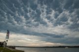
Later in the afternoon the Casino to Urbenville HP supercell was in full swing. The mammatus display was impressive downstream at least !


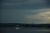
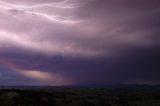
A lot of lightning was visible from Ballina - which is about 50ks from the storm core. A bit of structure was evident too.


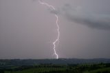
Some lightning when back at home


All photos for 29 December 2008

Michael

« Last Edit: 02 January 2009, 06:53:02 AM by Jimmy Deguara »
Location: Mcleans Ridges, NSW Northern Rivers
Australian Severe Weather:   http://australiasevereweather.com/
Lightning Photography:   http://www.lightningphotography.com/
Early Warning Network: http://www.ewn.com.au
Contact: Michael Bath

Jeff Brislane

  • Guest
Wow, those hailstones from Kenibri are huge! That giant stone in the first pic might be almost 10cm going by my own hand width across my knuckles of 9cm.

Offline Mike

  • Australian Severe Weather Moderators
  • Wedge tornado F5
  • *
  • Posts: 1,348
  • Gender: Male
  • Dry season here...boring!
    • http://StormscapesDarwin.com
OMG!  They're huge.  Certainly an impressive set of nails there.... :o
Darwin, Northern Territory.
StormscapesDarwin.com
Lightning Research 2010/14

Offline Jimmy Deguara

  • Australian and Tornado Alley storm chaser
  • Administrator
  • Wedge tornado F5
  • *
  • Posts: 2,218
  • Gender: Male
  • Storm Chaser since 1993, Tornado Alley 2001
    • Australia Severe Weather
Jeff,

I prefer to be a little more conservative in the size of the hailstones - I would say 8 - 9cm maximum. Her hands look smaller than a typical large hand. Still, that is an impressive effort given that giant hail events on this scale are few and far between!

Regards,

Jimmy Deguara
-------------------------------------
Australian Severe Weather
www.australiasevereweather.com

Australian Thunderbolt Tours
www.thunderbolttours.com

Phone  0408 020468  (International :  61  2  408 020468)

Offline Kristy Norman

  • Elephant Trunk F2
  • *
  • Posts: 120
  • Gender: Female
Those fingernails are going to be famous!! Hope their cars were undercover!

Offline Michael Thomas

  • Elephant Trunk F2
  • *
  • Posts: 172
  • Gender: Male
Really top photos there. Amazing storm with jaw dropping structure. Would be interesting to know the moisture depth at the time of the storm. It would seem from the soundings that only the lowest 50 to 100mbar was moist. Interesting to see the amount of instablity higher in the troposhere. If you took the LI at 300 instead of 500 mbar, the LI would be well below -10 (as pointed out on WZ). The combination of a shallow but extremely unstable boundary layer with moderate-strong wind shear may have favoured the classic supercell structure due to lower precipitation loading on the storm's updraft.

Also, looking at the 256 brisbane radar it appears if another powerful supercell formed of the sunshine coast later in the evening. A large V notch is clearly present for a considerable time.

Michael

leo76

  • Guest
Jeff,

I prefer to be a little more conservative in the size of the hailstones - I would say 8 - 9cm maximum. Her hands look smaller than a typical large hand. Still, that is an impressive effort given that giant hail events on this scale are few and far between!

Regards,

Jimmy Deguara

Yeah but once you add those nails into the equation .....

Offline Peter J

  • Stove pipe F3
  • *
  • Posts: 419
  • Gender: Male
  • Lets go get em boys!
...Also, looking at the 256 brisbane radar it appears if another powerful supercell formed of the sunshine coast later in the evening. A large V notch is clearly present for a considerable time.

Michael

That storm system came flowing through on radar about 10.50pm that night - saw it too.

Big Pete
PJJ

Offline Michael Bath

  • storm chaser
  • Administrator
  • Wedge tornado F5
  • *
  • Posts: 1,602
  • Gender: Male
    • Australian Severe Weather
Michael T - comparing the two Brisbane soundings, the moisture is marginal earlier in the day but it is still fairly good to near 600hPa. There's quite a cap which was eroded by additional moisture from the N - NE (shown on the Casino and Lismore obs previous page). The main supercell passing over Lismore appears to have established a strong easterly inflow, perhaps assisted by outflow from the smaller cell that tracked from SW of Coraki to Evans Head?

Overall moisture improves by the evening sounding which would be more representative of conditions when a couple of cells were still powering along just off the coast.


---> All my photos for 30 December 2008


These are other photos by Beck Armytage taken on the eastern outskirts of Goonellabah


Location: Mcleans Ridges, NSW Northern Rivers
Australian Severe Weather:   http://australiasevereweather.com/
Lightning Photography:   http://www.lightningphotography.com/
Early Warning Network: http://www.ewn.com.au
Contact: Michael Bath

Offline Jimmy Deguara

  • Australian and Tornado Alley storm chaser
  • Administrator
  • Wedge tornado F5
  • *
  • Posts: 2,218
  • Gender: Male
  • Storm Chaser since 1993, Tornado Alley 2001
    • Australia Severe Weather
Nice inflow tail in one of the latter pictures from Beck.

I am now thinking that this storm began as an LP supercell and traversed along the supercell spectrum to become classic as suggested by one of the nice pictures nearer Byron Bay. Very little if any precipitation is falling fom the supercell and mostly lrge to giant hailstones which to me supports a more Low Precipitation environment and behaviour. Love the structure too!

Take a look at the similarity in some respects to the Low Precipitation supercell at Camden 12th February 2003:

http://www.australiasevereweather.com/storm_news/2003/docs/200302-01.htm

Regards,

Jimmy Deguara
-------------------------------------
Australian Severe Weather
www.australiasevereweather.com

Australian Thunderbolt Tours
www.thunderbolttours.com

Phone  0408 020468  (International :  61  2  408 020468)

Offline Antonio (stormboy)

  • Stove pipe F3
  • *
  • Posts: 481
  • Gender: Male
hey nice video there just  one question what is an LP super cell?

regards stormboy