Author Topic: Major Flooding Event for Northern NSW and S QLD & NE SA March 2010  (Read 28326 times)

0 Members and 1 Guest are viewing this topic.

Offline Shaun Galman

  • Stove pipe F3
  • *
  • Posts: 441
  • Gender: Male
    • ridgelightning.com
Hi guys,

I thought I'd share a few photos and info from the current major flooding of the rivers here in our area inc. the Narran River, Coocoran Lake and the Big Warrambool flood plain that is South of Lightning Ridge on the Castlereagh Highway. The river has now isolated Angledool and Goodooga (both to the North of us here at Lightning Ridge) Russ and I ventured up to the Narran for a look and a few shots on Tuesday the 16th of March and then again yesterday (Thursday the 18th) to check on the rising readings that are expected to peak by Sunday and then remain for several weeks to come.

I have a few shots from Tuesday that show the Narran River height to be 2.6metres (pictured in one of the photos below). This rose to 2.9metres on Thursday and at this point had covered the road on the other side of the Jim Harper bridge at Angledool by about 30cm. I believe the town has since become isolated as the ground level slopes towards the houses there from the river. I will check the river level again this afternoon or tomorrow morning and also keep a check on the Big Warrambool to the South of Lightning Ridge. This area of highway was completely washed away in the floods of 1974 and also went under water in the more recent flood events over the 80's and 90's.

Another area we monitor is the area where the Narran overflows into the Angledool Lake (a wetland area) and then comes down and crosses the Castlereagh Highway around 25k's North of the Ridge (locals know this as the Weetalibah Crossing) and then proceeds to fill the mighty Coocoran Lake. We are surprised this area has not seen any water as yet but it will take time to fill the Angledool Lake before moving through. It's usually a torrent when it moves between the ridges and into the Coocoran.

I will keep an eye on things and post information as it comes to me, hopefully a few photos also. This is supposedly the biggest event in 84 years for these rivers so I'll be glad to record it as best as I can! The peak will be sustaind for a long time to come so it seems I will have plenty of opportunity for photography etc.

The first photo is taken on the Narran bridge at Angledool looking South (upstream). The second is on the bridge looking NNE. The third has the inset of the gauge where all the Narran measurements are taken from. These are accessible through the BoM or SES websites. All these photos were taken on Tuesday the 16th of March while the river was still very much rising.
 
Kindest regards,
Shauno.

*feel free to send Mosquito and Sandfly repellent!!!  ;)
Chasing Region: Lightning Ridge. N.S.W.
Website: www.ridgelightning.com

Offline Shaun Galman

  • Stove pipe F3
  • *
  • Posts: 441
  • Gender: Male
    • ridgelightning.com
RE: Major Flooding Event for Northern NSW and S QLD & NE SA March 2010
« Reply #1 on: 21 March 2010, 04:11:08 PM »
Hi all,
Thought I'd just add another photo that I took yesterday (Friday the 19th of March 2010) of the road into Angledool N.S.W. This road is under around 40cm of water. The houses in the town (if you can call it that) are actually about a metre lower than the river's maximum height. This is the reason for the evacuations. Strange to think Angledool was a thriving city in the late 18 to early 1900's. It had a very large populous and three major Hotels at it's heart. The few surviving photos from that era are amazing to see! Just looks like they were taken in the centre of Sydney at that time.

The Narran river has currently peaked at somewhere between 2.9 and 3metres. Still no sign of the water crossing the Castlereagh Highway and on into the Coocoran Lake as yet. We'll keep checking periodically.

Kindest regards,
Shauno.
Chasing Region: Lightning Ridge. N.S.W.
Website: www.ridgelightning.com

Offline Shaun Galman

  • Stove pipe F3
  • *
  • Posts: 441
  • Gender: Male
    • ridgelightning.com
RE: Major Flooding Event for Northern NSW and S QLD & NE SA March 2010
« Reply #2 on: 22 March 2010, 12:19:17 PM »
Hi all,
Had an interesting afternoon's photography! The Weetalibah crossing (25k's North of Lightning Ridge on the Castlereagh Highway) went into major flood today (even though it was dry as a bone late yesterday afternoon). This is the biggest anyone including myself has seen it! This is the area that feeds the Coocoran Lake and the water is already making it's way into it as Russ and I found out by walking the 2k's through the scrub to see it (as all the roads are obviously closed) flowing in way off in the distance. The highway will be very much washed away at the Weetalibah crossing. We waded out into it up to our knees and there was still a further 100mtrs to the deepest and strongest flowing area. Didn't push things as we could hardly stand up where we were.
No doubt this current height of 40cm over the road will increase a bit as the days go by.

It took 14days to fill the Coocoran Lake in 1991 (that was only a minor flood event, covering the highway at the crossing by 10cm at most) but this time I'd bet around 8-10days as the flow is tremendous, maybe even less time than that? I have plenty of photos to share but also we have 3 weeks of peak waters to play with as far as photography goes. I will post a few tomorrow as we'll be heading out this evening for exposure shots of the 40cm high rapids.

Just waiting on the Big Warrambool to go into flood now (25k's South of Lightning Ridge on the Castlereagh Highway) which does so from the Moonee River so we found out today. That river was at 5mtrs so the flooding through there should be spectacular as it's as flat as a tack out there on the black soil plains!

We have several planes circling all day, everyday on floodwatch. There have been a few large levees built around our power sub station and sewerage works just on the edge of the ridges as a precauton.

Have a look at the Lightning Ridge area on Google Earth and you will see the Coocoran inflow region North of town and the Warrambool flood plain South of town. When you see how flat the areas around the ridges are you can see why there is some panic at the moment.

I'll keep posting on events. Coocoran Lake will be extremely impressive to see when full as it covers a massive distance and gets to about 3.5mtrs deep in the middle.

Kindest regards,
Shauno       
Chasing Region: Lightning Ridge. N.S.W.
Website: www.ridgelightning.com

Offline Shaun Galman

  • Stove pipe F3
  • *
  • Posts: 441
  • Gender: Male
    • ridgelightning.com
RE: Major Flooding Event for Northern NSW and S QLD & NE SA March 2010
« Reply #3 on: 22 March 2010, 05:24:10 PM »
Hi guys,
Here's a quick photo I took this afternoon of the floodwaters making their way into the Coocoran Lake via the Weetalibah crossing on the Castlereagh Highway. This was bone dry early this morning and is now half a kilometre wide and 45-50cm deep up on the highway and as much as 1.5mtrs deep on the right side of the highway (looking North as this photo is)! I waded out but could hardly stand up and I got nowhere near the strongest flowing area. There were foot high rapids where we were positioned. None of the locals have ever seen it this large before. Russ and I went out again tonight and it has risen about 10cm in a couple hours.  We got some stunning exposures on twilight but got absolutely hammered by mozzies and bugs lol!

Given the area of the Coocoran Lake (50square kilometres) and the fact it will fill in around 10 days just shows the volume of water coming through, considering it is already getting out into the lake now. I heard from a friend tonight that there is also water encroaching on town from the East now. It is around 6k's from the town area as of tonight. I will need to go inspect this as it has never come from that direction in anyone's memory.

I will post many more photos for you all and keep the reports coming in. This is one significantly large event by the looks.

Kindest regards,
Shauno.
Chasing Region: Lightning Ridge. N.S.W.
Website: www.ridgelightning.com

Offline Michael Bath

  • storm chaser
  • Administrator
  • Wedge tornado F5
  • *
  • Posts: 1,602
  • Gender: Male
    • Australian Severe Weather
RE: Major Flooding Event for Northern NSW and S QLD & NE SA March 2010
« Reply #4 on: 23 March 2010, 01:41:53 AM »
That is a very impressive change in conditions - really a flash flood at first would you say.  Thanks for posting all this information.

Are you able to show a Google Map with the locations you have photographed?

regards, Michael


attached map from:
http://www.bom.gov.au/hydro/flood/nsw/outerwest.shtml
Location: Mcleans Ridges, NSW Northern Rivers
Australian Severe Weather:   http://australiasevereweather.com/
Lightning Photography:   http://www.lightningphotography.com/
Early Warning Network: http://www.ewn.com.au
Contact: Michael Bath

Offline Shaun Galman

  • Stove pipe F3
  • *
  • Posts: 441
  • Gender: Male
    • ridgelightning.com
RE: Major Flooding Event for Northern NSW and S QLD & NE SA March 2010
« Reply #5 on: 23 March 2010, 06:45:29 AM »
Hi MB,

Definitely a flash flood of sorts. We waited a week for the water to arrive at this crossing and everyone was slightly skeptical whether or not it would actually get here.

We have heard that the water at the Weetalibah crossing has risen to four feet deep up over the highway which, if true, will be just spectacular to see! Russ and I will head out again soon for photos and an inspection. All the locals are preparing their boats and jet-ski's for the Lake when it fills. If the current depth is a true report then I would estimate the lake will fill in a matter of a few days.

Here is a link to Google Maps partially centered on Lightning Ridge. Weetalibah crossing is to the North of town (the easily spotted water run into the Coocoran Lake) and the Big Warrambool flood plain is to the South. I may be able to do a decent Google Earth screen shot with labels that will be a bit more informative. If you move the map slightly further North you can see the Angledool Lake and the Narran river. The Narran bridge is where the Castlereagh crosses the Narran River just before Angledool. This is where I took the first few photos.


http://maps.google.com.au/maps?client=firefox-a&hl=en&ie=UTF8&ll=-29.467101,147.810059&spn=0.428637,1.044388&t=h&z=11  
Chasing Region: Lightning Ridge. N.S.W.
Website: www.ridgelightning.com

Offline Peter J

  • Stove pipe F3
  • *
  • Posts: 419
  • Gender: Male
  • Lets go get em boys!
RE: Major Flooding Event for Northern NSW and S QLD & NE SA March 2010
« Reply #6 on: 23 March 2010, 10:28:42 AM »
Shaun,

Looks like you got water everywhere there... is it possible to send some of that down south and west for us dry people???

LOL

Pete
PJJ

Offline Richary

  • Barrel tornado F4
  • *
  • Posts: 680
  • Gender: Male
RE: Major Flooding Event for Northern NSW and S QLD & NE SA March 2010
« Reply #7 on: 23 March 2010, 01:19:32 PM »
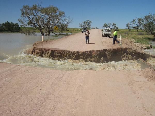
I think we can safely add NE South Australia to this event, this photo was taken yesterday about halfway up the Strezlecki Track between Lyndhurst and Innamincka (I had a geocache under the tree in the top left of the picture).  Water has overflowed from the Cooper Creek system into the Strezlecki Creek.


From the Transport SA website road conditions...

Issued Sunday 21st March 2010 at 3:11pm
A new report will be issued when any road conditions change.   

Status:

Strzelecki Track (Innamincka to Lyndhurst)

    *    Closed - Merty Merty To Moomba - Due to wash out of Strzelecki crossing .
    *    Open - The Knob To Mt Hopeless
    *    Open - Lyndhurst To The Knob
    *    Closed - Moomba To Della - Due to Strzelecki Creek flooding over Della Road.
    *    Closed - Della To Innamincka - Due to Strzelecki Creek flooding over Della Road.
    *    Closed - Mount Hopeless To Merty Merty - Due to wash out of Strzelecki crossing .

Birdsville Track (Marree to Birdsville)

    *    Open - Marree To Mungeranie
    *    Closed - Mungeranie To Birdsville - Due to rain .


Offline Paul D

  • Multi-vortex F1
  • *
  • Posts: 90
  • Gender: Male
Re: Major Flooding Event for Northern NSW and S QLD & NE SA March 2010
« Reply #8 on: 23 March 2010, 03:14:48 PM »
Here is a shot that probably sums up the the current state of the roads out Innamincka way

http://www.wrightsair.com.au/DSC_0023.JPG

There is a few other shots from the air of Birdsville, Cooper's Creek, Diamantina River, Eyre Creek - Bedourie on the same site

Cheers
Paul
« Last Edit: 23 March 2010, 03:22:03 PM by Paul D »

Offline Richary

  • Barrel tornado F4
  • *
  • Posts: 680
  • Gender: Male
Re: Major Flooding Event for Northern NSW and S QLD & NE SA March 2010
« Reply #9 on: 23 March 2010, 04:04:22 PM »
Yes have also seen similar shots of Innamincka recently. Have also heard that production from the Moomba Gas Fields may be affected as they are unlikely to be able to get supplies in by road for a few weeks. Not sure if the airstrip there will remain above water or not.

I wonder if Lake Eyre will get some decent water in it this year (time for a 4WD holiday maybe?). And also if ex TC Ului will be adding more to the upsteam catchments.

Offline Michael Bath

  • storm chaser
  • Administrator
  • Wedge tornado F5
  • *
  • Posts: 1,602
  • Gender: Male
    • Australian Severe Weather
Re: Major Flooding Event for Northern NSW and S QLD & NE SA March 2010
« Reply #10 on: 24 March 2010, 04:26:40 AM »
A couple of slideshows posted elsewhere:

http://www.lyndhursthotel.com.au/Strz.htm
http://www.lyndhursthotel.com.au/Flood.htm

The first one shows the demise of a large culvert - same place Richary posted a pic of.

Location: Mcleans Ridges, NSW Northern Rivers
Australian Severe Weather:   http://australiasevereweather.com/
Lightning Photography:   http://www.lightningphotography.com/
Early Warning Network: http://www.ewn.com.au
Contact: Michael Bath

Offline Shaun Galman

  • Stove pipe F3
  • *
  • Posts: 441
  • Gender: Male
    • ridgelightning.com
Re: Major Flooding Event for Northern NSW and S QLD & NE SA March 2010
« Reply #11 on: 24 March 2010, 05:11:15 AM »
Hi guys,

A few nice shots there too, very impressive! The water seems to be pretty much everywhere. The Darling River won't know what hit it when it gets there! 

Hi Big Pete,
I'd like to send you guys some, we have more than enough water here!

Russ and I were a little suspicious of the "claimed" 4foot rise of the floodwaters and soon found out it was spurious at best though these things happen when people get excited.

The waters had risen another 10cm which is still significant given the flood surge is a kilometre wide out on the Highway. The Coocoran Lake is filling rapidly now. Russ and I waded out into it up to our knees on the highway until flow and depth were too dangerous to continue and I felt something at my feet like the road was slightly higher and I said to Russ "That seems strange." I bent down and grabbed it only to lift a 80cm square piece of bitumen that had been washed loose from the road! We were only near the calmer parts and it's already washing the highway away there!

We had a surprise at the current water movements East of town on the old black soil Collarenebri road. On Sunday the 21st of March the floodwaters were situated 6kilometres form the town boundary (out where our artesian bore baths are situated) so Russ and I went for a drive along the road yesterday (Monday 22nd of March) and only got about 700mtrs or so and were immediately greeted by a brownish inland sea coming down the road towards us! The flow along the sides of the road was heavy enough to be cutting ditches through the black soil about 30cm deep. This road is going to be out for a very long time by the looks.

We also checked the Big Warrambool flood plains but that it still dry at the highway. What did alert us though was the presence of two helicopters circling above us and watching that area so no doubt it is moving through there and we'll see it at the highway soon. There are two Bailey bridges there that were put in place after the highway got washed away in the 1974 floods. The Castlereagh is very flat at this point (other than the two bridges) so I wouldn't like to say if it will be actually cut or not.

I have many photos to go through today so I will post them when I can. I'd like to get a few more of the encroaching Easterly floods today. At the rate it's moving I'd expect it to be near the artesian Bore Baths today (at the end of Pandora Street).

Kindest regards,
Shauno

Chasing Region: Lightning Ridge. N.S.W.
Website: www.ridgelightning.com

Offline Michael Bath

  • storm chaser
  • Administrator
  • Wedge tornado F5
  • *
  • Posts: 1,602
  • Gender: Male
    • Australian Severe Weather
Re: Major Flooding Event for Northern NSW and S QLD & NE SA March 2010
« Reply #12 on: 24 March 2010, 05:34:39 AM »
Another great update - thanks Shauno.   What you have described with the road breaking up is one of the biggest dangers with floodwaters. People know the road and think it's safe but then sections can be missing, yet not visible due to the water.  Their car can end up in big trouble - even if the waters are not fast moving.

MB


Location: Mcleans Ridges, NSW Northern Rivers
Australian Severe Weather:   http://australiasevereweather.com/
Lightning Photography:   http://www.lightningphotography.com/
Early Warning Network: http://www.ewn.com.au
Contact: Michael Bath

Offline Shaun Galman

  • Stove pipe F3
  • *
  • Posts: 441
  • Gender: Male
    • ridgelightning.com
Re: Major Flooding Event for Northern NSW and S QLD & NE SA March 2010
« Reply #13 on: 24 March 2010, 06:36:48 AM »
Hi MB,

Yes very true! Luckily the SES and Council have totally blocked access to the roads now. We actually witnessed someone driving out into the floods the other night while we were doing some photography! I have a few shots of these idiots that I may show as a- "What you shouldn't do in a major flood situation!"

The other issue we've seen is people taking small children in to swim in the waters while there are major culverts under the road in full force with large whirlpools on the intake side. These kids are swimming and playing merely feet away from these dangers!

The worse part is it will take a childs death to wake these mindless people up. I just hope it's not this time round.
Chasing Region: Lightning Ridge. N.S.W.
Website: www.ridgelightning.com

Offline Shaun Galman

  • Stove pipe F3
  • *
  • Posts: 441
  • Gender: Male
    • ridgelightning.com
Re: Major Flooding Event for Northern NSW and S QLD & NE SA March 2010
« Reply #14 on: 24 March 2010, 09:16:41 AM »
We went down to the end of Pandora Street (East of town) to the artesian Bore Baths and the water is about 300mtrs from the end of the bitumen (where the old Collarenerbri black soil road starts) Seems to be covering all the paddocks from what we could see. The SES and Council are appearing to be building a rather large levee around the artesian baths today. We cant do much in th way of photography there as the grass is about 60cm high on the plains but the old road looks like a river!

Just heard on the ABC radio that this entire area is under an emergency situation. They are now boating in supplies to Goodooga (and into Angledool I would imagine). We have three helicopters and an aeroplane on full time patrol here. Many farms and properties are now under water. I will do my best to get up in one of the choppers for a few shots if I can somehow arrange it.

Russ informed me earlier that according to the RTA website: The Castlereagh Highway is still OPEN to Hebel. I can well assure you it is absolutely NOT open! It's completely washed away in at least three areas that we know of, possibly more to come.

Here's an update of the photos from the last three days.
In order they are:

1. Taken on Sunday the 21st. Russ and I testing the waters. As you can see Russ is struggling against about 20cm in depth on the road. This was about half way out. I went just beyond this to about 45cm in depth but that was enough as I could hardly stand. It has since risen 10cm that we know of and even this point is now well out of reach.

Photos 2. and 3. are a before and after. The 2nd was taken Sunday the 21st and the third I took yesterday (Monday the 22nd) of the same area. Note the large runoff from the culvert, this is where people are letting their kids swim!

4. Taken on Sunday (21st March) night. This is a nice bit of evidence to show why the council and SES had to act fast to close the roads. People read: idiots! were actually driving out into the deep waters at night. God know what the hell they were trying to accomplish?

5. This was the old black soil Collarenerbri road yesterday (Monday the 22nd) afternoon. Taken about 1.5k's out on the dirt road from the artesian Bore Baths. Today it's visible from the end of the bitumen. I will get photos if I can. It's slightly treacherous out there now, not only getting stuck in the black soil but there are snakes in the tall grasses EVERYWHERE!

Kindest regards,
Shauno. 
Chasing Region: Lightning Ridge. N.S.W.
Website: www.ridgelightning.com