Author Topic: Coastal Rain/Storms SE QLD/NSW: 6-10 April 2008  (Read 27503 times)

0 Members and 1 Guest are viewing this topic.

Offline Michael Bath

  • storm chaser
  • Administrator
  • Wedge tornado F5
  • *
  • Posts: 1,602
  • Gender: Male
    • Australian Severe Weather
Coastal Rain/Storms SE QLD/NSW: 6-10 April 2008
« on: 07 April 2008, 01:18:43 PM »
Quite a nice sunset illuminated thunderstorm moved in from the southeast earlier. And there's been ongoing thunder and lightning every few mins since then - though all the heavy rain has been just north of my location so far.


Full set of photos for today are here:

http://australiasevereweather.com/photography/photos/2008/mb20080406.html

Location: Mcleans Ridges, NSW Northern Rivers
Australian Severe Weather:   http://australiasevereweather.com/
Lightning Photography:   http://www.lightningphotography.com/
Early Warning Network: http://www.ewn.com.au
Contact: Michael Bath

Offline Jason(pato)

  • Elephant Trunk F2
  • *
  • Posts: 136
  • Gender: Male
RE: Coastal Rain/Storms SE QLD/NSW: 6-10 April 2008
« Reply #1 on: 07 April 2008, 02:43:11 PM »
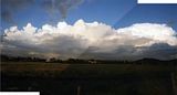
I got some pics of the same cell that MB got pics of, albeit from a bit further away, a different perspective anyway.. As MB mentioned it was nicely illuminated from the setting sun and went thru a broad spectrum of colours. Apologies for the quality of first pic, its my first attempt at a stitch, but you can get the general idea of the moment.


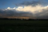
Next shows a possible guster nicely illuminated in the setting sun.


Also got a few pics of the sunset, was pretty impressive.


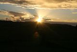
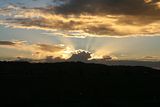
 Pics just don't do it justice.All in all this arvo was a pleasant surprise, and tomorrow may bring some more photo opportunities, however it'll be from the front porch lol.
South Lismore, Northern Rivers NSW.....Supercells are us!!

Offline enak_12

  • Elephant Trunk F2
  • *
  • Posts: 153
  • Gender: Male
RE: Coastal Rain/Storms SE QLD/NSW: 6-10 April 2008
« Reply #2 on: 07 April 2008, 06:10:29 PM »
Had some lightning active storms out to sea tonight around the NSW North Coast. I took some photos from the Coffs Jetty area.


Offline Jimmy Deguara

  • Australian and Tornado Alley storm chaser
  • Administrator
  • Wedge tornado F5
  • *
  • Posts: 2,218
  • Gender: Male
  • Storm Chaser since 1993, Tornado Alley 2001
    • Australia Severe Weather
RE: Coastal Rain/Storms SE QLD/NSW: 6-10 April 2008
« Reply #3 on: 08 April 2008, 12:39:10 AM »
Enak,

The lightning certainly illuminates the structure - good stuff!

We certainly have some cumulonimbus activity off our coast this morning. Even yesterday you got the impression the mid-levels of the atmosphere were cooling and generally it was  tending to becoming unsettled. During the evening there were showers that had developed - we had the edge of this shower most likely from the anvil.

It will be interesting if this is the start of another episode of activity from the La Nina - I mean where has it gone?

Regards,

Jimmy Deguara
« Last Edit: 08 April 2008, 01:24:15 AM by Jimmy Deguara »
-------------------------------------
Australian Severe Weather
www.australiasevereweather.com

Australian Thunderbolt Tours
www.thunderbolttours.com

Phone  0408 020468  (International :  61  2  408 020468)

Offline Steven

  • Global Moderator
  • Stove pipe F3
  • *
  • Posts: 410
  • Gender: Male
RE: Coastal Rain/Storms SE QLD/NSW: 6-10 April 2008
« Reply #4 on: 08 April 2008, 12:48:52 AM »
Interesting Michael you even spotted a rainbow...

They're saying showers with thunder for today and tomorrow so that really comes as no surprise.

In the last few days there have been some rather interesting sunrises but they're weren't worth the trouble.

That's all from me for today!

Offline Steven

  • Global Moderator
  • Stove pipe F3
  • *
  • Posts: 410
  • Gender: Male
RE: Coastal Rain/Storms SE QLD/NSW: 6-10 April 2008
« Reply #5 on: 08 April 2008, 01:00:20 AM »
I noticed that and they're now beginning to come onshore, I think in a few hours some places will cop a deluge (obviously).

La Nina is dying isn't it? I think the Bureau were saying something to this effect. Well I think these heavy showers and storms are the last remnants, although I wouldn't be surprised if this continual weather pattern follows through until winter, I made a mention of this in the general weather thread.

lollie3

  • Guest
RE: Coastal Rain/Storms SE QLD/NSW: 6-10 April 2008
« Reply #6 on: 08 April 2008, 01:41:04 AM »
Nice photos there ppl.  I like to seeing the clouds light up with lightning.

Offline dann weatherhead

  • Multi-vortex F1
  • *
  • Posts: 32
  • Gender: Female
    • Sydney Storm Chasers
RE: Coastal Rain/Storms SE QLD/NSW: 6-10 April 2008
« Reply #7 on: 08 April 2008, 03:39:53 AM »
Great pics MB!

We had one of those great little afternoons yesterday where the humid easterly needed something to kick it off - and ridge of the Lower Blue Mountains was that. We got some very heavy rain between 3pm and 7pm giving us 37.7mm.

The sky this morning have that unstable look to it once again. And with the uppers cooling off even more so today (-20 @ 500) and heat that is generated from the sun this morning will further destablise the atmosphere.
« Last Edit: 08 April 2008, 10:41:59 AM by Jimmy Deguara »

lollie3

  • Guest
RE: Coastal Rain/Storms SE QLD/NSW: 6-10 April 2008
« Reply #8 on: 08 April 2008, 07:40:42 AM »
Nice radar images on the Weatherzone site showing some rain on the way.  I also took some nice photos not 10 mins ago well I consider them to be nice ones anyway not bad for my 1st attempt lol.


« Last Edit: 11 April 2008, 07:50:26 AM by Michael Bath »

Offline Michael Bath

  • storm chaser
  • Administrator
  • Wedge tornado F5
  • *
  • Posts: 1,602
  • Gender: Male
    • Australian Severe Weather
RE: Coastal Rain/Storms SE QLD/NSW: 6-10 April 2008
« Reply #9 on: 08 April 2008, 09:23:57 AM »
The rainfall totals are adding up - but really only at a few coastal locations so far. Ballina Airport appears to be topping the list with:

44.4mm to 9am 6/4
45.2mm to 9am 7/4
28.0mm 9am to 3pm today

Radar does look impressive with widespread showers and lightning along the East Coast.

It was even -18 at 500hPa on the Brisbane sounding Dann - similar to yesterday though the upper level dry air is largely gone now.

Location: Mcleans Ridges, NSW Northern Rivers
Australian Severe Weather:   http://australiasevereweather.com/
Lightning Photography:   http://www.lightningphotography.com/
Early Warning Network: http://www.ewn.com.au
Contact: Michael Bath

Matt Pearce

  • Guest
RE: Coastal Rain/Storms SE QLD/NSW: 6-10 April 2008
« Reply #10 on: 08 April 2008, 10:05:55 AM »
Nashua, a small location just southwest of Bangalow, picked up 68mm in the 24 hours to 9am - its wettest day in 3 months and its highest April 24 hour total since records began in 2000.

Been some half-decent showers around coastal Sydney throughout the day...typically I managed to get caught in the heaviest of the lot walking up from the station to work this morning...my socks are still wet :/

Offline dann weatherhead

  • Multi-vortex F1
  • *
  • Posts: 32
  • Gender: Female
    • Sydney Storm Chasers
RE: Coastal Rain/Storms SE QLD/NSW: 6-10 April 2008
« Reply #11 on: 08 April 2008, 11:19:35 AM »
We were lamenting on the weekend the sort of upper temps we see now would've been most welcome a month ago....

Anyway - the updrafts here this morning were extremely solid - pileus all over the shop. I though the more saturated air might've cluttered things up a bit more - but the latest sounding shows a fractionally drier upper profile than this morning for Sydney. Interesting that Brissy shows -18, Sydney is @ -20 and Newcastle is @ -22.

The current WV image is interesting, showing a plume of moist air being dragged up from the SW over western NSW and QLD, curling around fetching a more easterly tap over NE NSW/SE QLD, while another moisture plume is being sucked up from the far SE, converging into the Central NSW coast - a fair amount of dynamism about the current setup.

Offline enak_12

  • Elephant Trunk F2
  • *
  • Posts: 153
  • Gender: Male
RE: Coastal Rain/Storms SE QLD/NSW: 6-10 April 2008
« Reply #12 on: 08 April 2008, 05:03:41 PM »
I managed to take some more photo's tonight, April 7.


Offline Jimmy Deguara

  • Australian and Tornado Alley storm chaser
  • Administrator
  • Wedge tornado F5
  • *
  • Posts: 2,218
  • Gender: Male
  • Storm Chaser since 1993, Tornado Alley 2001
    • Australia Severe Weather
RE: Coastal Rain/Storms SE QLD/NSW: 6-10 April 2008
« Reply #13 on: 08 April 2008, 05:06:36 PM »
Enak,

That is an eerie feeling with the light illuminating the rocks on the shoreline. Two nights in a row and you have lightning nearby. Not sure if the cumulonimbus clouds here are producing anything in the way of lightning - I assume we are too distant I guess.

Regards,

Jimmy Deguara
-------------------------------------
Australian Severe Weather
www.australiasevereweather.com

Australian Thunderbolt Tours
www.thunderbolttours.com

Phone  0408 020468  (International :  61  2  408 020468)

Offline Michael Bath

  • storm chaser
  • Administrator
  • Wedge tornado F5
  • *
  • Posts: 1,602
  • Gender: Male
    • Australian Severe Weather
RE: Coastal Rain/Storms SE QLD/NSW: 6-10 April 2008
« Reply #14 on: 09 April 2008, 06:55:00 AM »
Terrific shots of the storms again Kane - was nothing photogenic up this way yesterday or last night.

Rainfall figures for my place for the event:

15.8mm to 9am 06/04
15.2mm to 9am 07/04
29.4mm to 9am 07/04 and a further 19 today
« Last Edit: 10 April 2008, 03:08:03 AM by Michael Bath »
Location: Mcleans Ridges, NSW Northern Rivers
Australian Severe Weather:   http://australiasevereweather.com/
Lightning Photography:   http://www.lightningphotography.com/
Early Warning Network: http://www.ewn.com.au
Contact: Michael Bath