Author Topic: Sydney / Illawarra Storms: 29 March 2008  (Read 54225 times)

0 Members and 1 Guest are viewing this topic.

Offline Dave Nelson

  • Elephant Trunk F2
  • *
  • Posts: 172
  • Gender: Male
    • Stormy Sydney
Sydney / Illawarra Storms: 29 March 2008
« on: 30 March 2008, 01:58:18 PM »
  Hi Gang   

     nice wee storm late this afternoon formed between home (West Ryde) and the Paramatta area
I didnt have to travel far, just down to the wharf at the end of the street.

 the base showed quite reasonable structure at times and a good billowing updraught
lots of CC activity and a few CG's   lasted ~ 2 hrs before totally dying out and dissapating
some heavy rain and a small amount of pea sized hail.


cheers
Dave N
« Last Edit: 30 March 2008, 02:09:14 PM by Dave Nelson »

Offline Jimmy Deguara

  • Australian and Tornado Alley storm chaser
  • Administrator
  • Wedge tornado F5
  • *
  • Posts: 2,218
  • Gender: Male
  • Storm Chaser since 1993, Tornado Alley 2001
    • Australia Severe Weather
RE: Sydney / Illawarra Storms: 29 March 2008
« Reply #1 on: 30 March 2008, 02:40:28 PM »
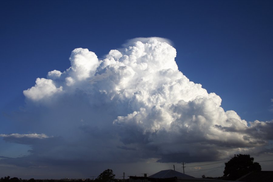
Good positioning Dave - I am glad you were able to observe the storm from the eastern perspective. I must say I was not looking properly and entrenched in my computer work and took a break and hell - pileus! I don't think it took more than a minute to grab the equipment and head to the car.

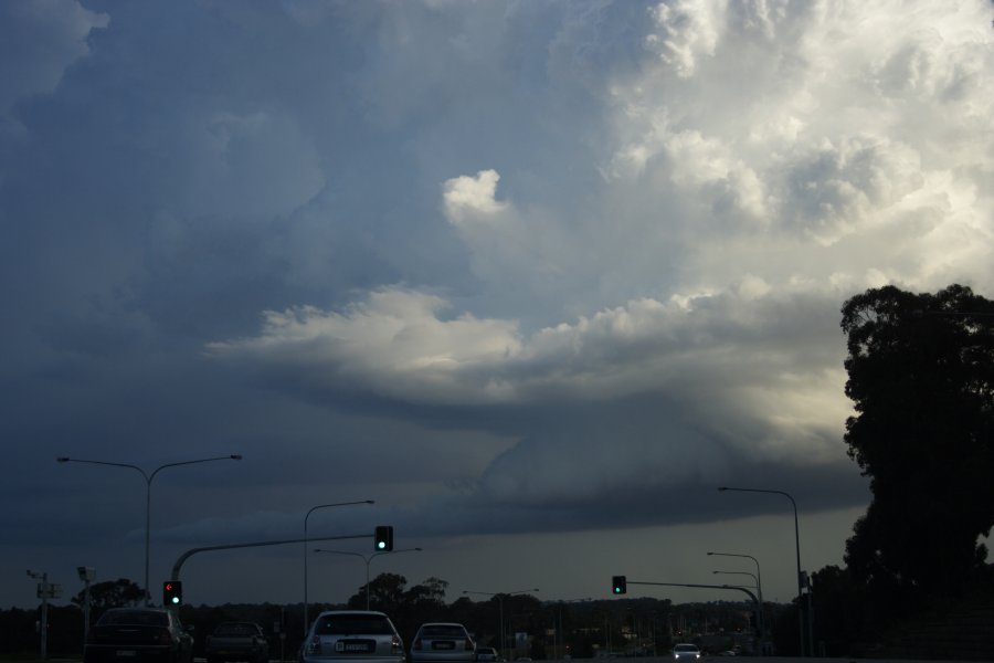
I only travelled down in the paddock to get buildings out of the way. The storm persisted as Dave said for quite some time - I have a decent amount of timelapse of updrafts and structure from the northwest perspective.

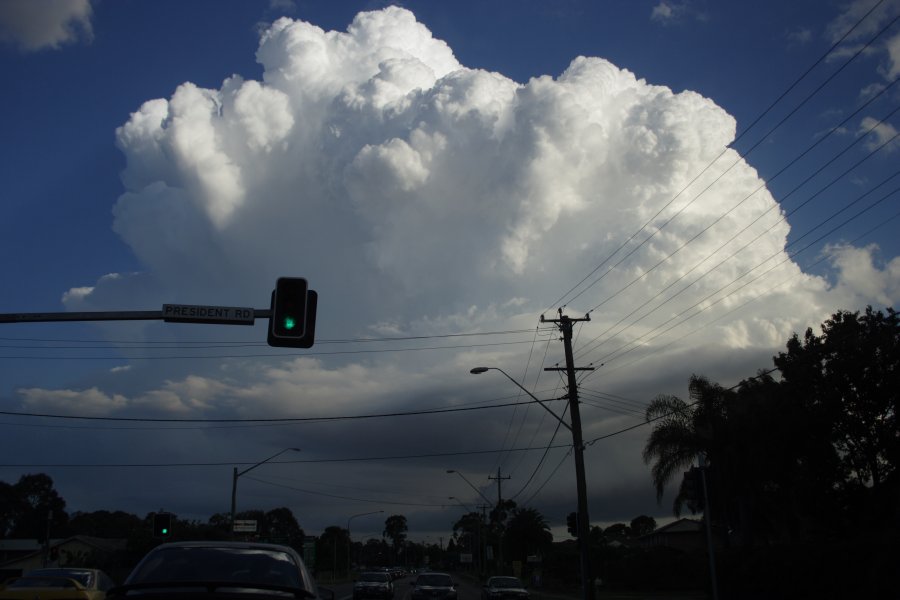
I then decided to give it a little chase to get slightly closer and a better angle on the storm. I got the angle I wanted but few vantage points. By the time I got to Baulkham Hills and Catle Hill, the storm was just beyond its strongest point and on a slow decline.

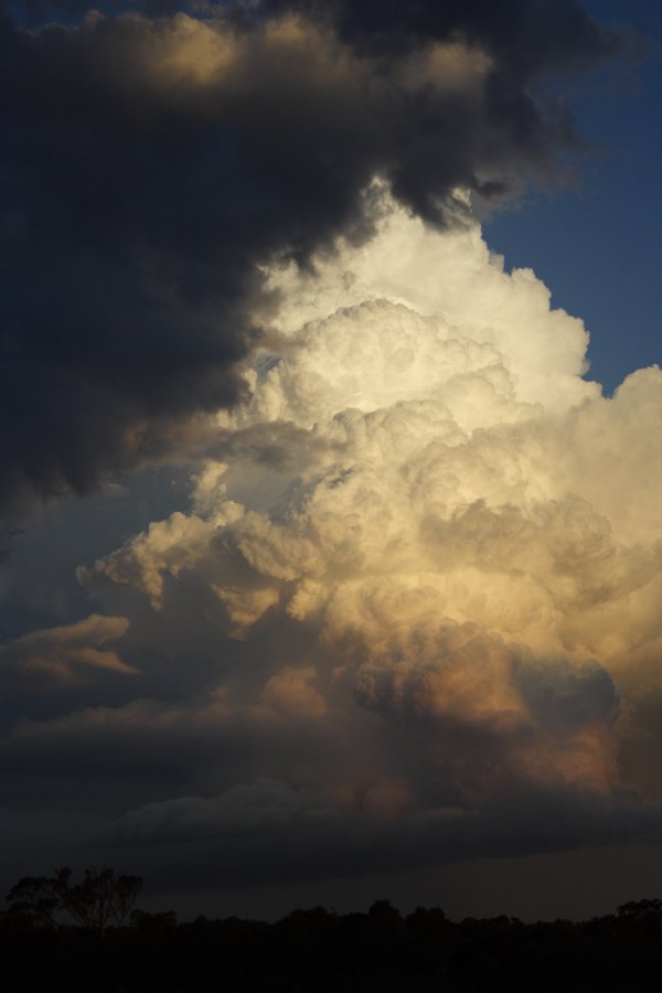
Nearer home, I got some sunlight back-lighting on the storm as it collapsed. The storm still maintained the inflow structure even as it shrunk. Here are a couple of pictures out of the 40 odd in the collection.

Schofields


Rouse Hill to Kellyville


Kellyville


Schofields


Regards,

Jimmy Deguara
« Last Edit: 31 March 2008, 08:56:08 AM by Jimmy Deguara »
-------------------------------------
Australian Severe Weather
www.australiasevereweather.com

Australian Thunderbolt Tours
www.thunderbolttours.com

Phone  0408 020468  (International :  61  2  408 020468)

Offline Richary

  • Barrel tornado F4
  • *
  • Posts: 680
  • Gender: Male
RE: Sydney / Illawarra Storms: 29 March 2008
« Reply #2 on: 30 March 2008, 02:43:31 PM »
It was an interesting little storm. From Rydalmere got a very similar view to the photo you took in it's early stage. First noted thunder while in brilliant sunshine. After a while we had intermittent hail pinging off the roof, just a few stones every 10-20 seconds. Had some quite heavy rain for brief periods as it dissipated to the east of us, obviously strong outflow happening by this stage as we had almost clear sky overhead yet torrential rain coming in initially from the SE then a more easterly directional falling on fair angle despite no wind at ground level.

As I write now I can see quite a lot of lightning that is probably intracloud from a storm the other side of Campbelltown. Too far away to see if there are any ground strikes but it is lighting up the interior of the clouds quite nicely and frequently.

heavywx

  • Guest
RE: Sydney / Illawarra Storms: 29 March 2008
« Reply #3 on: 30 March 2008, 03:09:18 PM »
Yeh it was certainly a lovely little storm, could see it quite clearly from my vantage point here on the Upper North Shore of Sydney. Was very interesting to watch it gradually rise in intensity and then, unfortunately, swing towards the coast in gradual dissapation. There was some further development around the Parramatta area, and for a moment, I thought we might be in for a chance as the storm veered to the NE slightly. Didn't eventuate, as the cell stalled & backed away down towards the Riverview area. Was nonetheless fascinating. But what's with this all of the sudden? I'm only a very amateur weather observer & am very unsure about exactly why random storms are popping up when a) the Bureau are not forecasting them and b) the synoptics clearly show no trigger whatsover in association with this random convective activity. Must say though, it's great when you have one cell in the Basin and the rest of the sky being virtually cloud-free (although some coastal cloud floated in in the latter parts of this afternoon & early evening). There's now a number of cells popping up, and it's good to see that the Bureau is on-the-spot now. They haven't picked these very random cells over the last few days, so it's time for some form Bureau! :) 8mm for me last night after those showers from the Hawkesbury River diverted their trajectory further south & east. Wonderful convergence line right now from just south-east of Warragamba Dam to 40-50km off the Wollongong coast. Looks good!  :)

Offline David C

  • Global Moderator
  • Barrel tornado F4
  • *
  • Posts: 643
  • Gender: Male
    • Thunderbolt Tours Storm Chasing Adventures
RE: Sydney / Illawarra Storms: 29 March 2008
« Reply #4 on: 30 March 2008, 05:00:32 PM »
We just has a decent late season storm come through here at Padstow with frequent lightning, gusty winds and heavy rain.

Earlier on this afternoon I had to finish up some work today and, by chance, while moving between buildings I spotted billowing updrafts to the west. After heading up a few levels I could see the base of a decent low precipitation storm slowly edge east towards North Ryde. It was stationary at one point.

Only had the phone with me, not prepared at all :)
 
Storm Chaser,
Thunderbolt Tours - USA & Australia Storm Chase Tours
www.thunderbolttours.com

Offline Dave Nelson

  • Elephant Trunk F2
  • *
  • Posts: 172
  • Gender: Male
    • Stormy Sydney
RE: Sydney / Illawarra Storms: 29 March 2008
« Reply #5 on: 30 March 2008, 05:12:05 PM »
great collection of pix all round   
cool to see same event from other angles

cheers
Dave

Offline Dave Nelson

  • Elephant Trunk F2
  • *
  • Posts: 172
  • Gender: Male
    • Stormy Sydney
RE: Sydney / Illawarra Storms: 29 March 2008
« Reply #6 on: 30 March 2008, 05:23:04 PM »
Hi again guys

   2315hrs and just back from another chase.    WOW 2 storms in one day so late in the season
Cindy and I chased down to Lucas Heights area, near the intersection of Heathcote Rd

Lightning VERY active from a series of cells stretching from offshore Wollongong and west to
Campbelltown.  The majority of the lightning was buried in the cloud but there were some good
CG's to be seen.   The gustfront, which was very menacing in the dark, lit up by the lightning and
streetlighting, passed over our position.  It was followed by torrential rain (no hail seen).

  We retreated to the Bankstown Centro shopping centre roof carpark and continued to video
the lightning from there for another 20 mins.   from here we could see regular CG's dropping down
to the far east .... probably offshore.
By 2230hrs the lightning had pretty much died out from the onland cells and we headed for home.

cheers
Dave N
« Last Edit: 30 March 2008, 05:31:09 PM by Dave Nelson »

Offline Jimmy Deguara

  • Australian and Tornado Alley storm chaser
  • Administrator
  • Wedge tornado F5
  • *
  • Posts: 2,218
  • Gender: Male
  • Storm Chaser since 1993, Tornado Alley 2001
    • Australia Severe Weather
RE: Sydney / Illawarra Storms: 29 March 2008
« Reply #7 on: 31 March 2008, 02:42:42 AM »
David and Dave and whoever else copped it down there, I am glad you had the action.

I saw the lightning even before David Croan came online to mention about it. Some nice cloud to cloud bolts - I did not see any cloud to ground bolts for the brief period I watched.


Comparison to 23rd March 1997 - discussion:
« Last Edit: 31 March 2008, 09:57:58 AM by Jimmy Deguara »
-------------------------------------
Australian Severe Weather
www.australiasevereweather.com

Australian Thunderbolt Tours
www.thunderbolttours.com

Phone  0408 020468  (International :  61  2  408 020468)

flipwx

  • Guest
Re: RE: Sydney / Illawarra Storms: 29 March 2008
« Reply #8 on: 31 March 2008, 05:02:57 AM »
The storm persisted as Dave said for quite some time - I have a decent amount of timelapse of updrafts and structure from the northwest perspective.

Nice photos everyone, I didn't have my camera on me at the time and was not at home so nothing from me. Always good to see what a bit of heat and colder upper temps can do, it always looked that there was at least a chance of something forming.

Jimmy with the timelapse can you confirm if there was any rotation in the updrafts at all?

Cheers

Offline Jimmy Deguara

  • Australian and Tornado Alley storm chaser
  • Administrator
  • Wedge tornado F5
  • *
  • Posts: 2,218
  • Gender: Male
  • Storm Chaser since 1993, Tornado Alley 2001
    • Australia Severe Weather
Re: Sydney / Illawarra Storms: 29 March 2008
« Reply #9 on: 31 March 2008, 06:14:51 AM »
Phil,

I will have to go through it and I might because WZoners are already claiming supercell status. To me it was too weak to be a supercell in terms of updrafts along and I did not detect any corkscrewing. I never detected any organised persistent rotation visually so I will confirm using my 30 odd minutes of timelapse.

Regards,

Jimmy Deguara
-------------------------------------
Australian Severe Weather
www.australiasevereweather.com

Australian Thunderbolt Tours
www.thunderbolttours.com

Phone  0408 020468  (International :  61  2  408 020468)

Offline Michael Bath

  • storm chaser
  • Administrator
  • Wedge tornado F5
  • *
  • Posts: 1,602
  • Gender: Male
    • Australian Severe Weather
Re: Sydney / Illawarra Storms: 29 March 2008
« Reply #10 on: 31 March 2008, 06:36:04 AM »
Some weather data

---> Kurnell radar loop


GFS Analysis Saturday 29/03/2008 06z

Instability: CAPE / Lifted Index

Relative Humidity: 0300 / 0500 / 0600 / 0700 / 0850 / 1000

Temperature: 0300 / 0500 / 07000850 / 1000

Winds (knots): 0200 / 0300 / 0500 / 0600 / 0700 / 0850 / 0925 / 1000


Sydney 19z

Sydney 04z
Location: Mcleans Ridges, NSW Northern Rivers
Australian Severe Weather:   http://australiasevereweather.com/
Lightning Photography:   http://www.lightningphotography.com/
Early Warning Network: http://www.ewn.com.au
Contact: Michael Bath

Offline Jimmy Deguara

  • Australian and Tornado Alley storm chaser
  • Administrator
  • Wedge tornado F5
  • *
  • Posts: 2,218
  • Gender: Male
  • Storm Chaser since 1993, Tornado Alley 2001
    • Australia Severe Weather
Re: Sydney / Illawarra Storms: 29 March 2008
« Reply #11 on: 31 March 2008, 08:31:07 AM »
Hi,

Here is at least 15 minutes of the storms life cycle in timelapse at 40 times speed. People can judge for themselves as to whether there is a sustained deep rotating updraft:

 Afternoon Sydney Storm timelapse 29th March 2008

This is the Camden LP supercell 2003 as a comparison from a slightly different perspective:

Camden LP supercell 12th February 2003

I would also like to draw attention to this cell from September 19th 2004

http://www.australiasevereweather.com/video/stills/2004/20040919.html


Regards,

Jimmy Deguara
« Last Edit: 31 March 2008, 08:44:08 AM by Jimmy Deguara »
-------------------------------------
Australian Severe Weather
www.australiasevereweather.com

Australian Thunderbolt Tours
www.thunderbolttours.com

Phone  0408 020468  (International :  61  2  408 020468)

Offline TroyVR

  • Elephant Trunk F2
  • *
  • Posts: 113
  • Gender: Male
  • B.O.M Storm Spotter
Re: Sydney / Illawarra Storms: 29 March 2008
« Reply #12 on: 31 March 2008, 10:28:26 AM »
Bout 10Pm the storm hit Caringbah, Lots of lightning, mainly intracloud from where i was. Next to No Thunder came with the storm. But yeah i would of found a better vantage point and got pictures, except i had o start work early the next day and was too tired.

Offline Dave Nelson

  • Elephant Trunk F2
  • *
  • Posts: 172
  • Gender: Male
    • Stormy Sydney
Re: RE: Sydney / Illawarra Storms: 29 March 2008
« Reply #13 on: 31 March 2008, 11:23:12 AM »
Jimmy with the timelapse can you confirm if there was any rotation in the updrafts at all?
Cheers

Hi Phillip

   speeding up my movies of the storm showed a definate slow rotation of both the base
and the lower area of the updraught
Whilst watching the storm I was thinking that I could just make that out and the video
confirmed it.   Definately NOT the best or fastest rotation I have seen but it was there

cheers
Dave N

Offline Michael Thomas

  • Elephant Trunk F2
  • *
  • Posts: 172
  • Gender: Male
Re: Sydney / Illawarra Storms: 29 March 2008
« Reply #14 on: 31 March 2008, 11:23:47 AM »
Well I might as well post some photos of some lightning from last night. I had a great time at the lighthouse point in Wollongong watching the lightning. When I first arrived there was frequent CG lighting coming down north of Wollongong and what was really nice was that there was no rain. This is my first attempt of night time lightning photograpy and I am quite pleased with the results.


Yesterday came as a real suprise to me, I should have had more attention given the cold upper temps. LI of -6 is really quite respectable given the sounding is plotted at only 23/15. An interesting event I believe.

edit: Feel free to put links to the photos if you feel they are too large.

Michael