Author Topic: Significant storm event - January 27 and January 28 2010  (Read 11088 times)

0 Members and 1 Guest are viewing this topic.

Offline Jimmy Deguara

  • Australian and Tornado Alley storm chaser
  • Administrator
  • Wedge tornado F5
  • *
  • Posts: 2,218
  • Gender: Male
  • Storm Chaser since 1993, Tornado Alley 2001
    • Australia Severe Weather
Significant storm event - January 27 and January 28 2010
« on: 01 February 2010, 07:24:14 AM »
The January 27 2010 and January 28 2010 storm events are events worthy of mention, further discussion and investigation given the rare radar echo structures observed - namely hook echos. Furthermore, the location, close to a major populated area Sydney makes it more significant. Although no evidence of tornadoes have been observed until this point (and probably won't be), the events still are of concern given any number of cells could have become tornadic.

The January 27 2010 Dryline Supercell Outbreak with hook echo radar signatures
 
Although I don't have time at this point to research archives of the datasets, the 27th January 2010 produced several storms in the morning in the vicinity of the Central Tablelands and Central West Plains. A few of the cells in particular near Oberon and Orange moved east into a moist and very unstable environment. With a deep moist layer advecting westwards, shear profiles in the region near the southern parts of the Central Tablelands bordering Lithgow Jenolan, and the western part of the Wollemi were favourable for supercells. These storms became surface based and exhibited hook echos.

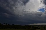
The first storm denoted as Storm A develops and quickly became severe, changes direction and produces the first hook about 40km south of Jenolan. The time period that best matches this behaviour is as follows

Begins 03:18 27/01/2010 UTC

Ends  04:24 27/01/2010 UTC


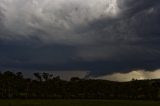
The second storm named as Storm B develops produces its hook towards the end of the life cycle of Storm A

Begins 04:18 27/01/2010 UTC

Ends 04:36 27/01/2010 UTC

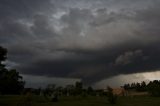
A third storm we will name Storm C develops a hook after 04:30 27/01/2010 UTC and last perhaps until about the 05:00 27/01/2010 UTC time frame. This is the classic supercell complete with wall cloud and precipitation RFD cascade I intercepted. The base was visually rotating and this one was comparitvely less impressive or long lasting in terms of radar signature!

Storm C


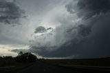
A fourth storm denoted Storm D develops to its immediate NNW and cramps Storm C perhaps limiting its supply of inflow and eventually they become embedded and join into a complex with another Storm E now south of Kandos. This complex eventually moved and perhaps develop an HP supercell structure heading north along the range towards Merriwa - perhaps tracking a boundary until 09:42 27/01/2010 UTC.


Base and possible wall cloud of Storm D


Storm E situated south of Kandos north east of my location


Both storms C and Storm D crossed the Lithgow - Mudgee road and dropped hail perhaps to at least golf balls (not measured) or larger based on stripped leaves observations!

The January 28 2010 Supercells with significant hook echo signatures

With ample moisture once again in place over the coastal regions near Sydney the Hunter and Southern and Central Tablelands, an upper trough of sorts or cooling depicted on the models provided the basis for the development of significant supercells in these regions (Michael please provide the afternoon soundings for Sydney on both days then delete this message).

After multiple non-severe storms developed and tracked across the area, the first supercell We will call Storm F became anchored in the moisture south of Katoomba and tracked left of the easterly steering flow consistent with supercell behaviour - intense echos, slower storm motion in this case. Unconfirmed reports of hailstones to the size of oranges were possibly reported near Springwood and hailstones to 2 inches reported in Winmallee and W of Medway.

A second storm named Storm G develops and moves left developing a hook echo by 06:06 28/01/2010 UTC passing directly over Colo Heights. Significant wind shear couplets are observed on doppler radar just prior to Colo Heights. According to Harald Richter, the storm exhibits a mesocyclonic eye at some point in the vicinity of Colo Heights indicating a singificant circulation.

Storm F continues through the Wollemi National Park and exits into the Hunter Valley region. 5cm hail was intercepted from another storm that moved from Putty the one we got to Branxton.


At 06:42 28/01/2010 UTC, a double hook echo is observed on radar and this coincides with the time of the video taken as Nick and I and the ABC crew pass through most likely the second hook echo looking into the periphery of the first hook. Time of the video is adjusted to 5:52pm AEDT.

hook echo base January 28 2010


Conclusion

There are at least 3 hook echos on the January 27 2010 outbreak of supercells. There are also at least 3 hook echos identified from the January 28 2010 event and in one case a double hook echo on the storm ner Colo Heights.  Hook echos are relatively rare signatures depicted on Autralian radar even in a 5 year return time frame. Who knows what the return period is for hook echos with such an event in Australian history. Moreso, what is the return period of a consecutive day event with multiple hook echo signatures experienced on both days.

I encourage your input and discussion. This is an advanced scientific and factual based discussion. Please do not input thoughts that are uneducated guess work. Please do point out observations out time and/or location specific observations that are backed up by reliable sources. If not enjoy the read. (Any poorly researched or unreliable posts will be removed from this particular discussion. Any questions, please start a separate thread in General Weather - no general questions regarding terminology please. If you are unsure, contact the moderators.)

Regards,

Jimmy Deguara

« Last Edit: 01 February 2010, 10:55:26 AM by Jimmy Deguara »
-------------------------------------
Australian Severe Weather
www.australiasevereweather.com

Australian Thunderbolt Tours
www.thunderbolttours.com

Phone  0408 020468  (International :  61  2  408 020468)

Offline Jimmy Deguara

  • Australian and Tornado Alley storm chaser
  • Administrator
  • Wedge tornado F5
  • *
  • Posts: 2,218
  • Gender: Male
  • Storm Chaser since 1993, Tornado Alley 2001
    • Australia Severe Weather
Re: Significant storm event - January 27 and January 28 2010
« Reply #1 on: 01 February 2010, 05:15:48 PM »
John,

That is a very detailed analysis of the events. Thanks for the inpout.

Quote
Jimmy, in terms of rotational direction and storm development, did we have a left rotational member dominant or a uniform splitting supercells? Would you say the storm E/D complex was a singular large supercell with in a MC cluster, or more of a bow-echo structure?

The first supercell Storm C I observed I cannot tell if it was a split but the well formed formation suggests it was the dominant if a split occurred.

What you may find interesting in terms of further discussion are the timelapse. The first one is obviously a left mover with clockwise rotation about the wall cloud and RFD precipitation cascade.

The second supercell I chased Storm D certainly showed signs of a wall cloud but timelapse from my perspective does not clearly show rotation in any direction. Was there undercutting? I will place this online in due course for further discussion.

I have the opinion that Storm E developed with a left mover structure with no splitting. It had a left flanking line with a large base. I cannot confirm rotation or supercell status with this event but the initial phase of develop of the updraft from a cumulus stage showed clear signs that the storm was already willing to rotate.

Another point I would like to add was that there possibly was a moisture gradient north of these cells. The storm near Mudgee was definitely higher based even taking into account the drop of 500 metres in elevation. I couldd clearly see moisture being advected into the the cumulus stage development of Storm E.

Sadly, I did not continue to chase the complex of cells C D and E as I was hoping for an isolated cell that turned out to be the Mudgee event. Less competition - better chance of survival.

Regards,

Jimmy Deguara
-------------------------------------
Australian Severe Weather
www.australiasevereweather.com

Australian Thunderbolt Tours
www.thunderbolttours.com

Phone  0408 020468  (International :  61  2  408 020468)

Offline nmoir

  • Elephant Trunk F2
  • *
  • Posts: 200
  • Gender: Male
  • "busting chases since 1999"
    • Oculi.com.au
Re: Significant storm event - January 27 and January 28 2010
« Reply #2 on: 02 February 2010, 04:24:10 AM »
Though i doubt they will add much to the discussion here are 3 images from the 28th , the first being the supercell which went through Hazelbrook , you can see the beavertail . the 2nd and 3rd images are taken at the same time as jimmys video just north of Colo Heights under the base
Nick Moir
Photographer
The Sydney Morning Herald
and www.oculi.com.au

Offline Michael Bath

  • storm chaser
  • Administrator
  • Wedge tornado F5
  • *
  • Posts: 1,602
  • Gender: Male
    • Australian Severe Weather
Re: Significant storm event - January 27 and January 28 2010
« Reply #3 on: 02 February 2010, 05:19:16 AM »
The radar loops from Terrey Hills radar can be accessed from the links below. Switch to broader scale or Doppler images as necessary.


128km Radar Loop for Sydney (Terrey Hills), 02:00 27/01/2010 to 08:00 27/01/2010 UTC


128km Radar Loop for Sydney (Terrey Hills), 00:00 28/01/2010 to 10:00 28/01/2010 UTC


Sydney Soundings. Afternoon sounding for the 27th is not available but you can see the previous trace on the morning of the 28th.


Location: Mcleans Ridges, NSW Northern Rivers
Australian Severe Weather:   http://australiasevereweather.com/
Lightning Photography:   http://www.lightningphotography.com/
Early Warning Network: http://www.ewn.com.au
Contact: Michael Bath

Offline nmoir

  • Elephant Trunk F2
  • *
  • Posts: 200
  • Gender: Male
  • "busting chases since 1999"
    • Oculi.com.au
Re: Significant storm event - January 27 and January 28 2010
« Reply #4 on: 03 February 2010, 03:20:42 PM »
I had a pretty long day searching along alot of fire trails and tracks near to the area where a tornado may have been but the only damage i saw was some leaf and twig stripping on a trail 4km north of mountain lagoon near Bilpin. having a look from the lookout there i could see no damage or tracks but this is very rugged and remote territory.
Nick Moir
Photographer
The Sydney Morning Herald
and www.oculi.com.au

Offline Richary

  • Barrel tornado F4
  • *
  • Posts: 680
  • Gender: Male
Re: Significant storm event - January 27 and January 28 2010
« Reply #5 on: 03 February 2010, 04:08:40 PM »
Being away in Vic last week missed the action, but that storm that formed near Mittagong on the 28th late in the loop (amybe 08 UT) looks quite interesting in the way it spread after the initial core formed. While I wasn't specifically looking for storm damage on the drive back up the Hume on Saturday didn't see anything unusual - and would have noticed had there been an unusual amount of debris on the side of the road.

Offline David C

  • Global Moderator
  • Barrel tornado F4
  • *
  • Posts: 643
  • Gender: Male
    • Thunderbolt Tours Storm Chasing Adventures
Re: Significant storm event - January 27 and January 28 2010
« Reply #6 on: 05 February 2010, 05:39:57 AM »
Just one other point to add to the above good discussion. Notwithstanding that storms on the 28th were wet classic to HP, another factor which makes these events all the more interesting, as far as potential for tornadoes, is the richness of the boundary layer moisture. This can be seen on the various soundings above. Very low dewpoint depressions are evident - all the chasers out and about will verify that the bases were particularly low on the 28th, and probably the 27th too. In addition, and equally important, the last Sydney sounding pasted up above also indicates a low LFC -- certainly no lower than 2000m and I'd suggest somewhere around 1000m in the pre-storm environment.

Jonathon Davies has some nice articles on the relationship between these two parameters to the extent that the relate to the development of tornadic supercells.


http://www.jondavies.net/LLthermo.PDF
Storm Chaser,
Thunderbolt Tours - USA & Australia Storm Chase Tours
www.thunderbolttours.com

Offline Jimmy Deguara

  • Australian and Tornado Alley storm chaser
  • Administrator
  • Wedge tornado F5
  • *
  • Posts: 2,218
  • Gender: Male
  • Storm Chaser since 1993, Tornado Alley 2001
    • Australia Severe Weather
Re: Significant storm event - January 27 and January 28 2010
« Reply #7 on: 06 February 2010, 06:07:03 AM »
Hi David and John,

John - interesting analysis of the 27th January supercell outbreak.

Quote
Very low dewpoint depressions are evident - all the chasers out and about will verify that the bases were particularly low on the 28th, and probably the 27th too.

Given the elevation, you would have anticipated that storm bases would almost be on the ground but they weren't. There were not as low in respect to being at about 1000 metres but they were sufficient to be of concern given real time rotation and timelapse of the storm. Had the storm not had competition from further north, this storm may have come close to producing. At no time did the storm show evidence of weakening or transformation into an HP supercell system for the 20 minutes or more of observing it. Such a tendency to form classic - HP supercell is an all too familiar scenario in Australia. The competition with the other cell to its immediate north also did not help in the strength and temperature of the inflow which could have enhanced low level rotation. The development of a sustained RFD is to me an encouragin sign for organisation although no RFD slot could be observed at any time either. An important component also to be considered given the dry line development is that cold air ourflow was not an issue.

Furthermore, I have unconfirmed reports from the region near Cullen Bullen (perhaps those working in the mines). Cars that were hit by this storm may have had hail dents similar to the Blacktown supercell that occurred on 9th December 2007. So estmiates of hail size would be in the range of 6 to 8cm although no known actual measurements as yet (just this observation and also the leaf litter). This supports John's analysis of a very intense core.

Regards,

Jimmy Deguara
-------------------------------------
Australian Severe Weather
www.australiasevereweather.com

Australian Thunderbolt Tours
www.thunderbolttours.com

Phone  0408 020468  (International :  61  2  408 020468)

Offline Michael Thomas

  • Elephant Trunk F2
  • *
  • Posts: 172
  • Gender: Male
Re: Significant storm event - January 27 and January 28 2010
« Reply #8 on: 09 February 2010, 12:51:57 PM »
Certainly an interesting event. Great analysis, makes for good reading. What strikes me, as David mentioned, is the quality of low level moisture. Rarely in Australia do we see discrete storms firing with such low LCL's. The 9th of December Blacktown supercell formed in a higher CAPE environment but the LCL was significantly higher from memory (temp/dp approx. 32/21??).