Author Topic: Severe Thunderstorms SE QLD and NSW 14 - 18 January 2010  (Read 33279 times)

0 Members and 1 Guest are viewing this topic.

Offline Macca

  • Elephant Trunk F2
  • *
  • Posts: 171
RE: Severe Thunderstorms SE QLD and NSW 14 - 18 January 2010
« Reply #15 on: 18 January 2010, 05:07:43 PM »
Just got back from a 750km chase (or so) to Grafton and back. Decided that there was better moisture and cooler upper levels down there leading to better instability. Also better shear down in NE NSW today than SEQ so all things pointed to down there.

Managed to get an eyefull of that cell which moved N up the coast from near Coffs to Grafton and it displayed some pretty tasty updrafts. At the same time, a line of cells developed near Grafton itself and moved NE. These looked nice for a while (refer photos earlier in this thread) before it gusted out quite wildly. Winds estimated up to 80km/h in the biggest gusts. This outflow pushed well ahead of the storm so I headed back up to near Casino and the outflow boundary from the Grafton storm then kicked off a nice storm S of Coraki so I went after that. This had some great structure for a short(ish) while before it suffered the same fate as the Grafton storm. This was to be expected given the strong instability and weak shear. I eventually pulled the pin quite early and kinda missed the stuff which went up close to Casino/Kyogle area later. ALl storms in this area today exhibited some really nice updrafts and overshoots at times but they all suffered from the same outflow fate. All in all a really nice chase day - was good to get out there amongst it again. I'll try and get some photos up but don't hold your breath...next weekend might be the first time I get a chance (assuming I'm not TC chasing).

I heard a report of 3cm hail near Coraki from the earlier storm.

Macca

Offline Antonio (stormboy)

  • Stove pipe F3
  • *
  • Posts: 481
  • Gender: Male
RE: Severe Thunderstorms SE QLD and NSW 14 - 18 January 2010
« Reply #16 on: 18 January 2010, 05:53:25 PM »
Hey guys today was a great day by far. It all started out with a humid morning and it was 30 by the time the clock struck nine. At around 1:20pm the first cells started to develop in the Bonalbo area. They moved northeast towards Murwillumbah and dissipated very quickly. Now by the time it reached 1:40pm a cell developed west of Woolgoolga. It intensified and took a north north-easterly track before going directly north. By 3:50pm the cell made impact at Wooli.

At 5:50pm the cell that originated in the Woolgoolga area made it all the way up north to Coraki where a deep brown core developed. The cell had overshooting cumulonimbus growth above the anvil. At 7:10 another deep red cell developed east of Bonalbo and moved east causing a mushroom bomb look with the anvil. At the same time another cell just southwest of Coraki had developed with a deep dark brown core. It and the Bonalbo cell got near each other and then another cell had developed between the two at around 8:30pm.

By 9:00pm the cell had made its way east towards Lismore, Ballina, Alstonville, Byron and Lennox head with many CG’s and a never ending lightshow. The cell moved Closer to Byron bay but made impact as far south as Ballina.

Overall a good day. Nice to see those structures and especially witness the sound of present thunder.
The images are as follows:
1)   At a lookout in Ballina overlooking the development and movement from the Woolgoolga cell near Yamba.
2)   The anvil stretched out as far as the eye could see.
3)   A snap shot of the overshooting cumulonimbus development bursting through the anvil.
4)   The Cell nears Ballina.
5)   with a nice Structure before completely collapsing.

Unfortunately I have no images of the lightning from tonight’s cell due to my cameras batteries going flat but I’m pretty sure Mathew Townsend has got some of the cell.
Below you will find a link to today’s Grafton Radar.

Antonio (storm boy)

See : 128km Radar Loop for Grafton, 13:00 16/01/2010 to 13:00 17/01/2010 UTC
« Last Edit: 19 January 2010, 04:50:06 AM by Antonio (stormboy) »

Offline Macca

  • Elephant Trunk F2
  • *
  • Posts: 171
RE: Severe Thunderstorms SE QLD and NSW 14 - 18 January 2010
« Reply #17 on: 19 January 2010, 01:57:00 AM »
Hi Stormboy,

Can you please provide some more details on the "tornado sighting" near Wooli.  Where did you hear this report?  What time?  Where was it?  Any photos? 

Thanks,

Macca

Offline Rodney Wallbridge

  • Multi-vortex F1
  • *
  • Posts: 71
  • Gender: Male
    • Red Bubble
RE: Severe Thunderstorms SE QLD and NSW 14 - 18 January 2010
« Reply #18 on: 19 January 2010, 04:24:02 AM »
Hi all, Jason,Michael and myself got out for a chase on sunday. We set off with expectations as much as one can jam the amount of model guideance and on the ground Obs with thoughts of the best outcomes to see a few storms. We took off to Grafton and watched some stuff getting organised and decided to "Core Punch" in south grafton. Now that was fun!! destructive winds and small hail with some very close lightning! Drove out of that and proceeded to head north again and basically had a lovely drive back to Coraki where back near Casino we set up and took a few more pics. Thanks for a great arvo fellas! Was nice to get "Hammered" as normally i stay out of the storms  Here's a few of my pics good to see a few others got amongst it rather then sitting at home.


Offline Michael Bath

  • storm chaser
  • Administrator
  • Wedge tornado F5
  • *
  • Posts: 1,602
  • Gender: Male
    • Australian Severe Weather
RE: Severe Thunderstorms SE QLD and NSW 14 - 18 January 2010
« Reply #19 on: 19 January 2010, 04:26:58 AM »
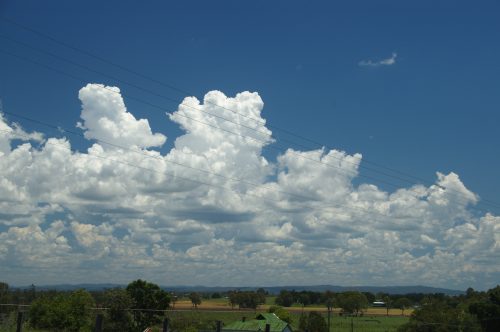
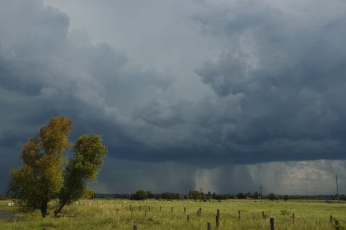
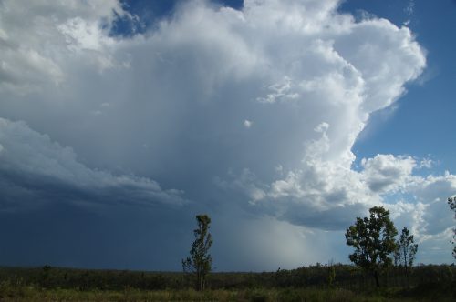
Storm Chase Report: NSW Northern Rivers 17 January 2010

Indications were that the northern parts of the region would not fire until later so Rodney Wallbridge, Jason Paterson and I headed south to Grafton. This was the sky near Casino just before we left.


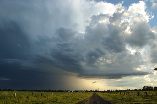
A storm had gathered strength west of Woolgoolga by the time we arrived in Junction Hill (just north of Grafton) and was tracking NNE.


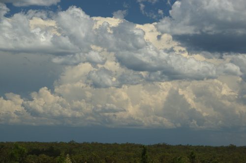
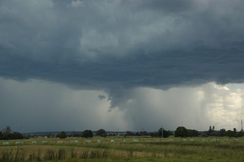
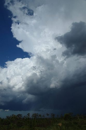
The updrafts were powerful with some overshoots though the base was a bit elevated.


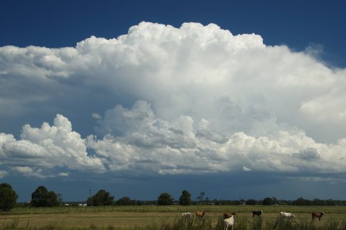
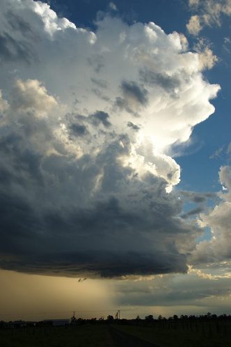
Other storms were gathering in a more favourable location to the southwest around the Nymboida area. Despite the heat (and a bit of sunburn!) we enjoyed this developing storm system which would be our target for the next three hours.


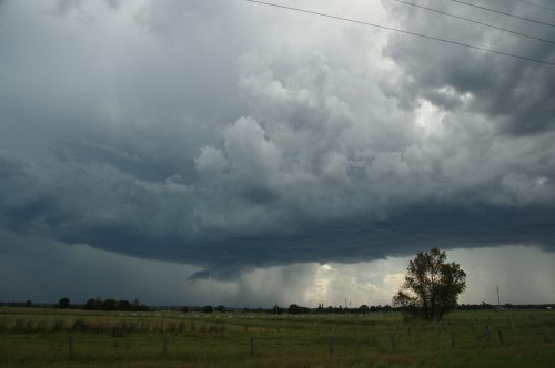
There was not a great deal of observable lightning but the high contrast structure was very nice. Microbursts were certainly a feature today.


We let the storm develop just enough before the decision was made to see what the storm was producing - ie. I wanted to get some hail. We drove through Grafton and by the time we were crossing the Clarence River strong gusts were hitting. The lightning had certainly ramped up too.


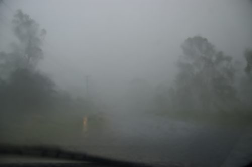
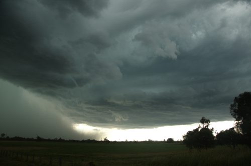
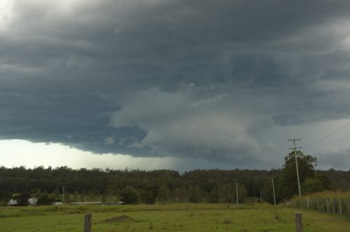
 A shelf cloud structure was to the west but we proceeding south through South Grafton then out the Raleigh/Nymboida Road (almost exactly the same location as the chase on 28th November 2009). Wild torrents of wind blown rain battered the area. The visibility seemed to be zero at times. We crawled southwards to find a spot clear of any immediate danger from falling trees. Wave after wave of microburst energy smashed around. Numerous shotgun CGs hit - it was awesome!  The only disappointing part was the lack of large hail - only some 1 to possible 1.5cm stones fell. The initial W-SW gusts switched to E-NE from the rear flank.


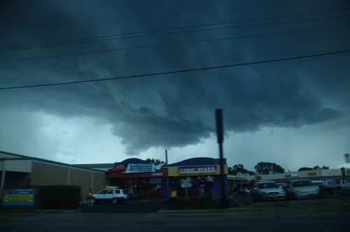
The slow moving nature of storms today ensured the onslaught lasted quite a while - but did cause damage in Grafton and South Grafton.

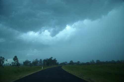
We drove back north and out the core then took the Lawrence Road from Grafton northeast and moved straight back into the wild weather. Again torrents of rain fell in the microbursts and some small hail.

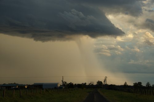
Just near Lawrence we were clear of the rain and able to see a spectacular microburst to the west.


A couple of pics then we had to race northwest to get through a tree lined road before that microburst caught up with us. We just made it although it looked dodgy at times.

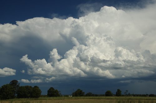
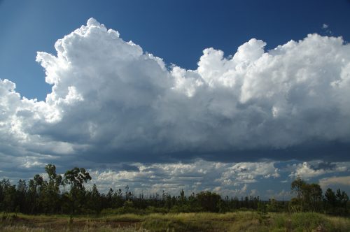
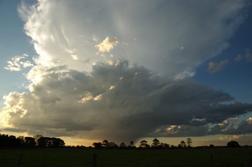
Back on the Summerland Way at Whiporie the storm was again looking beautiful with powerful new updrafts. Other activity to our SW only had our attention briefly.


The aim now was to get back into the main storm. We took a gravel road which cut across to Coraki saving over 30ks of driving had we gone to Casino then back ESE.  The road was actually quite good (for gravel) and our timing ended up fairly ideal, exiting the forest straight into the storm's core again!  Another microburst and some 1 - 1.5cm hail too.


This storm weakened very rapidly after that.

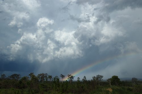
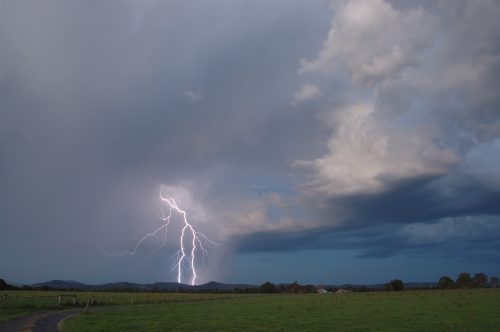
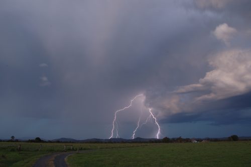
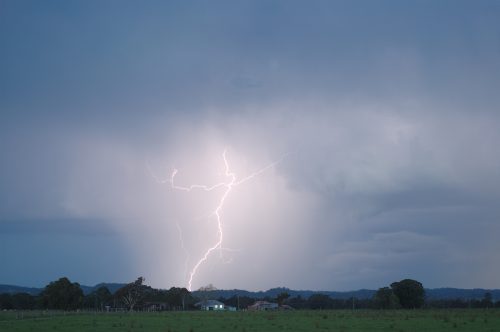
We moved WNW to near Casino as the sunset drew near. Other cells were developing - one initially southwest of Casino had some lovely structure though high based. The lightning was not very frequent but there were a number of clear air CGs.


Another storm developing very quickly to the west of Casino and ended up tracking over Lismore Alstonville etc into the evening. This gave an awesome display of lighting, though infrequent at first. Being around sunset produced some lovely colours.


At great chase and a nice way to mark the 9th anniversary of the Casino Supercell.

Michael
Location: Mcleans Ridges, NSW Northern Rivers
Australian Severe Weather:   http://australiasevereweather.com/
Lightning Photography:   http://www.lightningphotography.com/
Early Warning Network: http://www.ewn.com.au
Contact: Michael Bath

Offline Antonio (stormboy)

  • Stove pipe F3
  • *
  • Posts: 481
  • Gender: Male
RE: Severe Thunderstorms SE QLD and NSW 14 - 18 January 2010
« Reply #20 on: 19 January 2010, 04:33:31 AM »
I do not have any photos the tornado was reported By EWN in an SMS alert according to the sms it was a land spout and made touchdown for 20 seconds. Matthew Townsend might have more on this as he told me about a tornado first.

or it may be on EWN site http://www.ewn.com.au/

Antonio

Offline Michael Bath

  • storm chaser
  • Administrator
  • Wedge tornado F5
  • *
  • Posts: 1,602
  • Gender: Male
    • Australian Severe Weather
RE: Severe Thunderstorms SE QLD and NSW 14 - 18 January 2010
« Reply #21 on: 19 January 2010, 04:58:24 AM »
I seriously doubt that Antonio. EWN only sends out BoM warnings and no additional info unless the BoM put that in the text of their warning product - which it didn't as far as I can see from the warning archives. Can you please paste in what you have, or type what the SMS had?

I guess it's a Matt Townsend message..... not EWN !

regards, Michael
Location: Mcleans Ridges, NSW Northern Rivers
Australian Severe Weather:   http://australiasevereweather.com/
Lightning Photography:   http://www.lightningphotography.com/
Early Warning Network: http://www.ewn.com.au
Contact: Michael Bath

Offline Antonio (stormboy)

  • Stove pipe F3
  • *
  • Posts: 481
  • Gender: Male
RE: Severe Thunderstorms SE QLD and NSW 14 - 18 January 2010
« Reply #22 on: 19 January 2010, 05:00:45 AM »
I seriously doubt that Antonio. EWN only sends out BoM warnings and no additional info unless the BoM put that in the text of their warning product - which it didn't as far as I can see from the warning archives. Can you please paste in what you have, or type what the SMS had?

I guess it's a Matt Townsend message..... not EWN !

regards, Michael
I apologise for I misread my SMS it was as part of a warning. Next time i will read it more carefully. Apologies again.

Offline Michael Bath

  • storm chaser
  • Administrator
  • Wedge tornado F5
  • *
  • Posts: 1,602
  • Gender: Male
    • Australian Severe Weather
RE: Severe Thunderstorms SE QLD and NSW 14 - 18 January 2010
« Reply #23 on: 19 January 2010, 05:24:46 AM »
ABC North Coast did an interview this morning at about 8.35am

http://www.abc.net.au/news/stories/2010/01/18/2794609.htm?site=northcoast

Quote
The State Emergency Service received 50 calls for help after a violent thunderstorm ripped through parts of the Clarence Valley yesterday afternoon.

Dave Mackie, from the Clarence-Nambucca SES, says roof damage was the major problem, especially in the South Grafton area.

He says a motel lost parts of its roof and several houses and industrial sheds were also damaged.

"No injuries which was quite fortunate, but we did have seven teams of SES working up until midnight last night putting tarpaulins up and doing temporary repairs to a lot of roofs and removing a lot of trees that had fallen over," Mr Mackie said.

The manager of the Jacaranda Motor Lodge, Tony Stackhouse, says a 12-metre-long section of his roof was ripped off.

"And it was in one full section, and it travelled probably 50 metres over the top of the trees and it landed on the pool fence about 50 metres away, in one piece," Mr Stackhouse said.

"The grounds here they look, they certainly look like a tornado hit them, there's tree branches from one end fo the place to the other, it just stripped quite big branches right off the trees," he said.

Wollongbar-based storm chaser Michael Bath drove to the Clarence Valley to witness the wild weather.

He says although the winds were extreme, the storm itself moved slowly and he was able to follow its path for several hours.

"There wasn't a huge amount of lightning apart from right in the core and there was a number of close bolts that hit so close to the car that the whole thing vibrated from the effect of the lightning bolts hitting trees adjacent to us," Mr Bath said.

"Joe Public wouldn't want to put themselves in that situation but you sort of know the safe spots and certainly being in a car is one of those," he said.

Tags: storm, grafton-2460, south-grafton-2460
Location: Mcleans Ridges, NSW Northern Rivers
Australian Severe Weather:   http://australiasevereweather.com/
Lightning Photography:   http://www.lightningphotography.com/
Early Warning Network: http://www.ewn.com.au
Contact: Michael Bath

Offline Jimmy Deguara

  • Australian and Tornado Alley storm chaser
  • Administrator
  • Wedge tornado F5
  • *
  • Posts: 2,218
  • Gender: Male
  • Storm Chaser since 1993, Tornado Alley 2001
    • Australia Severe Weather
RE: Severe Thunderstorms SE QLD and NSW 14 - 18 January 2010
« Reply #24 on: 19 January 2010, 10:09:06 AM »
Hi,

Good to see some action up and down the coast yesterday. Nice interview Michaal (good to see the message was passed on when she called me:)) Antonio, thanks for changing the message to a more accurate one - accuracy is paramount on this forum. That does not take it away from the chase you had - great stuff! Just report what you see out there and only report terminology you understand.

Chase Report coastal Hunter 17th January 2010

After pondering whether I should chase yet again, I suddenly realised that this was not your typical SE change. Winds had come into Sydney but it seems there was evidence of a possible meso-low (or at least some form of circulation) on the central coast to be situated near Newcastle later. The Hunter Valley was out of my chase territory on this day though the Bulahdelah was another possible target. So with the promise of fish and chips for the family later (evil grin), we headed up towards Newcastle.

Some crisp updrafts north of Sydney


Taking the turn-off just after the last anvil, we remained in the Toronto area. The storms were producing nice anvils but then the bases would become less organised. Remaining in this region for about an hour, the pattern persisted with cores passing to our south.


We decided to check out one of the cores relocating in Belmont. Suddenly I looked up and there was a nice anvil's southern edge observed through a gap. Was this just another false alarm? A bolt rips down from this anvil perhaps 2km away. The rain eases and the base across the lake begins to consolidate. One bolt followed by another. A wet microburst descends and more bolts follow. The two dense precipitation curtains were merging.

A move north was in order and immediate. Before we knew it, the storm was closing in rapidly. Bolts including multiple staccatos were now hammering down from the side anvil. A green tinge seem to be devloping in the rain free base. A main intersection - Newcastle or the Link Road? We changed lane to head for Maitland in hope to get the storm northeast of Newcastle.

Precipitation curtain and base consolidating west of Belmont - this storm also was changing direction slightly


Nice side anvil


Base with green tinge


Unfortuntaely, it was too slow. Newcastle may not have been much better regardless but at least we may have been in a better part of the core. Extremely heavy rain occurred in the immediate suburbs west of Newcastle. Once on the road east of Hexham, the storm was already to our east and we gave chase.

Updrafts with storm to our east


Precipitation curtains


Next updraft keeping the storm alive along the flanking line


The storm exhibited some nice updraft structure and a nice possible hail shaft descended from the back side lit up by sunshine. Perhaps a nice severe multicell. Heading east seemed to make difference though we ran out of road ending up in Nelson Bay. The structure had weakened briefly but another solid updraft had developed on the northwestern flank. The base was drawing in some  easterly to northeaserly inflow but we never got a good look at the base as it headed off the coast.

Storm off the coast of Nelson Bay


After some photographs, it was time for fish and chips! More storms would approach and head off the coast and intensify accordingly.

Another storm arrives and intensifies


The trip home was interesting too. A line of storms (low-topped and no anvils) was once again moving through the southern Hunter centred near Toronto. Would have made for some interesting lightning photography but I decided against with a later night arrival already in order for the family.

Regards,

Jimmy Deguara
-------------------------------------
Australian Severe Weather
www.australiasevereweather.com

Australian Thunderbolt Tours
www.thunderbolttours.com

Phone  0408 020468  (International :  61  2  408 020468)

Offline Mathew Townsend

  • Elephant Trunk F2
  • *
  • Posts: 151
  • Gender: Male
  • Watching storms since 1998
RE: Severe Thunderstorms SE QLD and NSW 14 - 18 January 2010
« Reply #25 on: 19 January 2010, 10:13:00 AM »
Hey all

Great lightning show after sunset last night. I managed to capture over 5 lightning bolts, some were just retina burning! I gave up after MB gave me message that long lived cell died on our footsteps. This new cell formed over Lismore gave me a surprise!

I will post my photos later this week.

Offline Jason(pato)

  • Elephant Trunk F2
  • *
  • Posts: 136
  • Gender: Male
RE: Severe Thunderstorms SE QLD and NSW 14 - 18 January 2010
« Reply #26 on: 19 January 2010, 12:06:36 PM »
I've got a few pics to add to Michaels. I won't go into to the details of the chase as it already has been covered pretty well by all who chased the area. Suffice to say that I had a very enjoyable time with MB and Roddy, and some of those car shaking flangs were just incredible. Anyway heres a selection of my favourite shots from the day, sorry if I double up on a few of the other quality pics in here.


Closer view of one of the incredible microbursts we experienced.


There was some very photogenic structure around at times as highlighted by this shot


And some nice lightning to finish the night (jpeg compression does no favours to this pics  :( If someone can point in the right direction for not losing quality from RAW to JPEG compression I'd be most grateful


Once again another enjoyable day storm chasing, which has been all too infrequent this season. Thanks to MB for driving.

Cheers Jason
South Lismore, Northern Rivers NSW.....Supercells are us!!

Offline enak_12

  • Elephant Trunk F2
  • *
  • Posts: 153
  • Gender: Male
RE: Severe Thunderstorms SE QLD and NSW 14 - 18 January 2010
« Reply #27 on: 19 January 2010, 01:20:43 PM »
Sweet shots everybody great stucture on these storms :) to bad the shear wasnt a bit stronger...this is what I photographed from home, had no petrol to head out far but oh well..


First two images are of the left split from the Woolgoolga cell


This is Boambee Headland on fire, some kids did it apparently, I thought it was from lightning.


Not much lightning to photograph later but I did find a flipped 4wd with some very lucky occupants escaping any injuries, got to be careful on slippery roads!! 

Offline Jimmy Deguara

  • Australian and Tornado Alley storm chaser
  • Administrator
  • Wedge tornado F5
  • *
  • Posts: 2,218
  • Gender: Male
  • Storm Chaser since 1993, Tornado Alley 2001
    • Australia Severe Weather
RE: Severe Thunderstorms SE QLD and NSW 14 - 18 January 2010
« Reply #28 on: 19 January 2010, 01:33:39 PM »
Enak,

Did the storm in the first and second photograph show rotation and structure for an extended period of time? Very interesting.

The photograph of one of the storms Michael et al got also showed interesting structure.

Regards,

Jimmy Deguara
-------------------------------------
Australian Severe Weather
www.australiasevereweather.com

Australian Thunderbolt Tours
www.thunderbolttours.com

Phone  0408 020468  (International :  61  2  408 020468)

Offline Richary

  • Barrel tornado F4
  • *
  • Posts: 680
  • Gender: Male
RE: Severe Thunderstorms SE QLD and NSW 14 - 18 January 2010
« Reply #29 on: 19 January 2010, 03:28:21 PM »
Some more fantastic storms everyone. I held some hope for action in Sydney given the BoM warning that went down as far as Wollongong initially and the EWN SMS I received. Unluckily action stayed north of my location and kept going further north. I did spot some pileus on one of the cells to my north, probably after it's best display would have been.

Will drag the camera out in the next day or so and download the pics.

The Sydney chasers should be right next week for action as I am off to Victoria (Warrnambool) for a few nights, camping a couple of nights along the way each direction - assuming it isn't either a heatwave or bucketing down!
« Last Edit: 22 January 2010, 01:29:06 AM by Jimmy Deguara »