Author Topic: NSW/QLD Storms and Rain Event: 22 - 28 October 2009  (Read 25383 times)

0 Members and 1 Guest are viewing this topic.

Offline Chris.

  • Multi-vortex F1
  • *
  • Posts: 52
  • Gender: Male
RE: NSW/QLD Storms and Rain Event: 22 - 28 October 2009
« Reply #30 on: 27 October 2009, 01:57:40 AM »
Location Warwick SE Qld Sun. 25/10/2009

Interesting day here yesterday. Convection started forming early over Cunningham's Gap with monumental towers. Very little rain from any of the cells forming here yesterday. They reached anvil and dissapated as quickly as they formed. This shots are taken of a cell that reached anvil over Killarney and I haven't processed the image yet but wondering if anyone saw the cell near Legume? Looked huge with anvil spreading for many k's. I got a side shot of it but wondering if anyone else saw it. I'm guessing it was near Legume but could have been much further away, 40-50km maybe.


Regards,
Chris.

Offline Michael Bath

  • storm chaser
  • Administrator
  • Wedge tornado F5
  • *
  • Posts: 1,602
  • Gender: Male
    • Australian Severe Weather
RE: NSW/QLD Storms and Rain Event: 22 - 28 October 2009
« Reply #31 on: 27 October 2009, 02:53:51 AM »
Hi Colin and all,

Those huge bullseye type rainfall totals usually mean the focus of thunderstorm activity but you rarely get as much as forecast. With the GFS model, the most reliable run is 12z, followed by the 00z run. The output from 18z and 06z are less reliable. Also, GFS continues to poorly forecast surface moisture and temps this season.

Chris, there were some explosive cells during the day but the moisture and shear profile meant they were going to be short-lived. There was a lot of CAPE available as illustrated in your photos.  Here's my view (taken from home at McLeans Ridges) of the cell north of Wiangaree about 0630z (530pm EDT).


This is the earlier cell that moved along the Gold Coast hinterland (from about 0230z, 1.30pm EDT)


Others for 25 October here


Much stronger and sustained storms moved through the Mid North Coast and into the lower Northern Rivers into the evening.


Michael

« Last Edit: 27 October 2009, 10:55:38 AM by Michael Bath »
Location: Mcleans Ridges, NSW Northern Rivers
Australian Severe Weather:   http://australiasevereweather.com/
Lightning Photography:   http://www.lightningphotography.com/
Early Warning Network: http://www.ewn.com.au
Contact: Michael Bath

Offline Jason(pato)

  • Elephant Trunk F2
  • *
  • Posts: 136
  • Gender: Male
Re: NSW/QLD Storms and Rain Event: 22 - 28 October 2009
« Reply #32 on: 27 October 2009, 04:52:48 AM »

25th October 2009


Gday All,

Well the last two days have been ones of frustration to say the least. So much potential only to be ruined by a lack of nice moisture. Yesterday looked like it had the potential to be an awesome day but again moisture let us down with most convection being high based and pulsey due to weakish shear.
After watching the radar and the sky I decided to make the decision to head out for a look and I made my way to Rods house around 130pm. There was some nice convection to the south which turned out to be the Dorrigo cell which had a nice radar signature for awhile. Not long after this a cell got its going on the Richmond Range and proceeded to make its way towards the Casino area. We could make out some base features albeit a tad unorganised but we decided what the hell and went for a look.


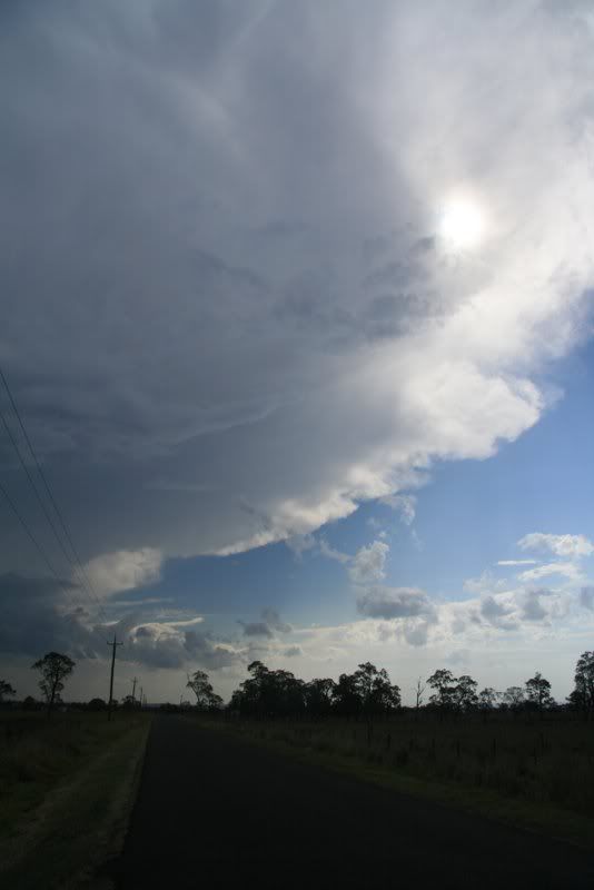
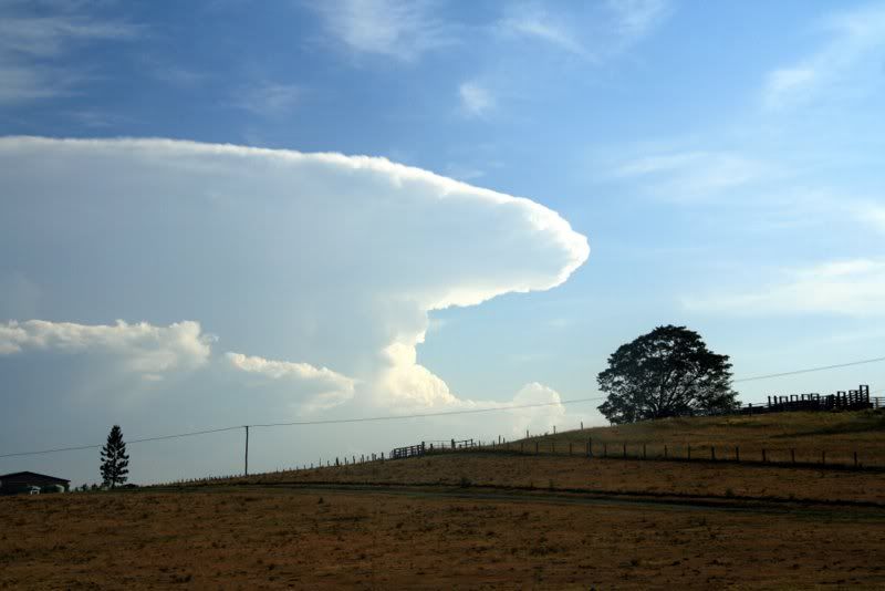
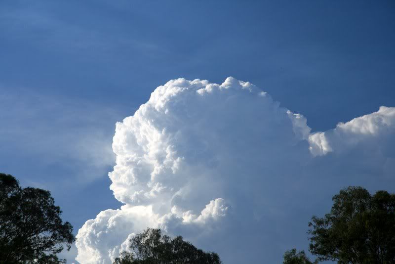
It had a nice anvil going but after travelling around 25kms south of Casino it collapsed and we decided to head back to Rods house to wait and see what else would pop up. This would turn out to be a mistake because as soon as we got back we could see some strong convection powering up again to the south around the Nymboida area. There was some very impressive updrafts going up and it certainly was very photogenic. The timelapse I took should be very nice. It appeared to have a backshearing anvil but I think this wasn't the case as the upper winds weren't that strong and it seemed to just pulse continually in the one spot.


This is the same cell that AC, Sercy and Andy were watching from Casino.
Whilst all this was happening strong convection had popped up to the north and Rod and I had to make a decision which way to go.


We opted for the southern cell as it looked the stronger so we headed towards the Whiporie area. When we arrived  we had a chaser convergence with AC and co. Again, frustratingly, the cell had lost all of its oomph and had all but died. After hanging around for about 1/2 an hour we decided that things weren't looking great so we made an executive decision to head back again and re-assess things at Rods house. Unfortunately Andy and his partner and his son had to head back home at this stage.
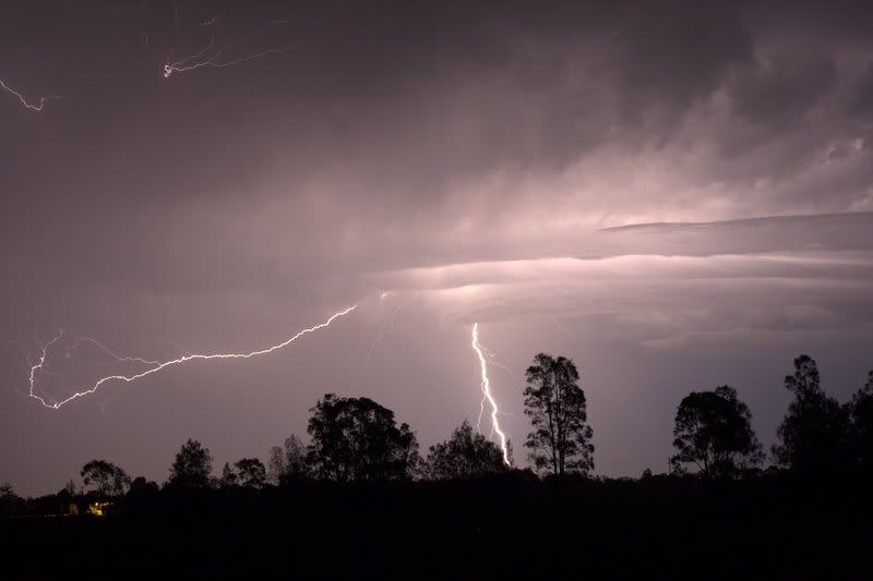
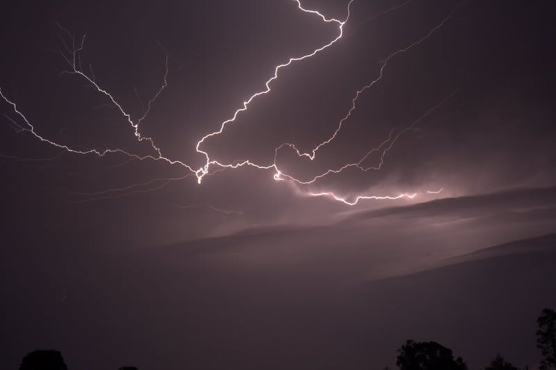
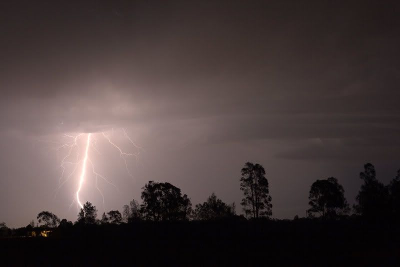
A quick radar check when we got back to Rods revealed that in fact some stuff had got its act together again to the south and distant lightning was visible from Rods house. It was showing some quite nice reflectivities on the radar so after much deliberation we all decided that heading towards Maclean might be the go. As per usual all the best lightning was occurring whilst in transit but eventually found a spot off the Pacific highway (old Pacific Hwy) and started snapping. There was some outstanding crawlers with a few nice CGs thrown in for good measure as well. Here are some of my favourites.


After watching this for around 45mins Stratto Cu started to fill in from the south so we decided to head a bit further south then west to try and get a vantage point for some more stuff developing to the west. The Stratto Cu deck made for difficult photography so after about 20 mins we decided to call it a night. It had been a very long day and with another 1 1/2 hrs on the road left it seemed to be the best call, even if the lightning had started to increase in intensity as we left. I ended up finally crawling into bed at 215am, 12hrs after I decided to head out    :o .
Considering how frustrating the day was was it was nice to finish it with some nice lightning shots and flashes accompanying us on the way home. Was great to catch up with AC, Sercy and Andy and I hope they enjoyed meeting the newest addition to the Storm Chasing community....Captain Supercell   :laugh: whose true identity may be revealed at a later date.   .
A special thanks goes to Rod who once again proved to me what herculean strengths of concentration he has to do all that driving. And thanks goes to Rods partner Sonya who was good enough to put up with us invading their house at 930pm.

Cheers Jason
South Lismore, Northern Rivers NSW.....Supercells are us!!

Offline Antonio (stormboy)

  • Stove pipe F3
  • *
  • Posts: 481
  • Gender: Male
Re: NSW/QLD Storms and Rain Event: 22 - 28 October 2009
« Reply #33 on: 27 October 2009, 09:27:13 AM »
Well it sure has been rainy also the pleasant sound of thunder has been heard over here for about 2hours now from the constant stationary cell east of us. A severe weather warning and flood watch are now current from a low developing northeast NSW area. The warning is

Priority
NSW SEVERE WEATHER WARNING
Local Flash Flooding,
For people in
Midnorth Coast, Northern Rivers
Issued at 3:20 pm on Monday 26 October 2009
Synoptic Situation: 3:00 pm EDT Monday
A trough lies over northeast NSW with a relatively weak, small scale low off the north coast. The low is expected to move to the west overnight, crossing the coast early Tuesday.
Local flooding is possible with thunderstorms this afternoon and evening but considered somewhat more likely overnight and tomorrow morning as the small low crosses the coast.
Emergency services advise do not enter flood water. Stay well clear of creeks, storm drains and causeways.


Now the flood watch

A low pressure trough over the northern parts of the state is expected to bring
showers, thunderstorms and rain to the northeastern and coastal parts of NSW.
Moderate to heavy rain is forecast for the Mid North Coast for Monday and
Tuesday.

Minor main river flooding is possible along the following river valleys, later
today (26/10/2009) and Tuesday (27/10/2009):

1. Orara River Valley
2. Bellinger River Valley

This Flood Watch means that people living or working along rivers and streams
must monitor the latest weather forecasts and warnings and be ready to move to
higher ground should flooding develop. Flood Warnings will be issued if Minor
Flood Level is expected to be exceeded at key sites along the main rivers for
which the Bureau of Meteorology provides a flood warning service. Across NSW,
about 70% of Flood Watches are followed by flooding.

storm boy

Offline Chris.

  • Multi-vortex F1
  • *
  • Posts: 52
  • Gender: Male
Re: RE: NSW/QLD Storms and Rain Event: 22 - 28 October 2009
« Reply #34 on: 27 October 2009, 09:44:34 AM »
Chris, there were some explosive cells during the day but the moisture and shear profile meant they were going to be short-lived. There was a lot of CAPE available as illustrated in your photos.  Here's my view of the cell north of Wiangaree about 0630z (530pm EDT).

Thanks for the explanation MB, appreciate it. Interesting to see the same storm from your side. This is the shot I mentioned earlier however I think the anvil in the distance is much further away than I first predicted. This is taken from Murrays Bridge (west of Killarney) looking south east in your direction at Wiangaree at 5pm est. Left side of the image, you can see part of the cell in the original cell behind Killarney. Even at 17mm wide angle I couldn't get them both in fame. Is it possible this is as far away as Casino and the same Anvil in Jason's photo?


Regards,
Chris.

Offline Jason(pato)

  • Elephant Trunk F2
  • *
  • Posts: 136
  • Gender: Male
Re: RE: NSW/QLD Storms and Rain Event: 22 - 28 October 2009
« Reply #35 on: 27 October 2009, 10:11:17 AM »
Thanks for the explanation MB, appreciate it. Interesting to see the same storm from your side. This is the shot I mentioned earlier however I think the anvil in the distance is much further away than I first predicted. This is taken from Murrays Bridge (west of Killarney) looking south east in your direction at Wiangaree at 5pm est. Left side of the image, you can see part of the cell in the original cell behind Killarney. Even at 17mm wide angle I couldn't get them both in fame. Is it possible this is as far away as Casino and the same Anvil in Jason's photo?


Regards,
Chris.


Hi Chris,

Looking at that photo I would almost guarantee thats the same cell I got pics of. The structure looks pretty much identical to what I was seeing. Just a shame it all collapsed by the time we got down to that area where it was.
South Lismore, Northern Rivers NSW.....Supercells are us!!

Offline Michael Bath

  • storm chaser
  • Administrator
  • Wedge tornado F5
  • *
  • Posts: 1,602
  • Gender: Male
    • Australian Severe Weather
Re: NSW/QLD Storms and Rain Event: 22 - 28 October 2009
« Reply #36 on: 27 October 2009, 10:58:01 AM »
Following on from Jason, and just to clarify - my photo was taken from home: McLeans Ridges. Your photo does have the cell north of Wiangaree I could see and the one SW of Whiporie Jason and Rodney saw.

MB
Location: Mcleans Ridges, NSW Northern Rivers
Australian Severe Weather:   http://australiasevereweather.com/
Lightning Photography:   http://www.lightningphotography.com/
Early Warning Network: http://www.ewn.com.au
Contact: Michael Bath

Offline Chris.

  • Multi-vortex F1
  • *
  • Posts: 52
  • Gender: Male
Re: NSW/QLD Storms and Rain Event: 22 - 28 October 2009
« Reply #37 on: 27 October 2009, 11:58:19 AM »
Thanks Jason and MB, that's a hell of a distance then! Jason, same thing happened to the cell behind Killarney (from my perspective) as MB explained. I wish I had made a pano now, get them both in. Next time! Thanks again fellas, was a great sight!!

Thankfully we have been getting steady rain since 3pm. The farmers will be happy!

Offline Harley Pearman

  • Barrel tornado F4
  • *
  • Posts: 584
Re: NSW/QLD Storms and Rain Event: 22 - 28 October 2009
« Reply #38 on: 27 October 2009, 12:42:10 PM »
Sydney Rainfall for 26 October 2009

Some areas of Sydney especially around Frenchs Forest and nearby Castle Cove had 114 and 112 mm of rain respectively for the period 9 am to 9 am 25 - 26 October 2009. The Frenchs Forest figure also includes the 65 mm that fell between 12 noon and 2 pm Sunday afternoon plus another 49 mm overnight.

Other big totals include 52 to 96 mm around the Sydney city area, 38 to 72 mm around the Sutherland region and some large falls around Hornsby. Falls of 38 to 49 mm fell around Blacktown.

The contrast between South West Sydney and Frenchs Forest is noteworthy. Only 5.4 mm fell at Camden and up to 16 mm around Campbelltown. The rain did not penetrate as well into South West Sydney as in other areas.

On the way to work early this morning, I drove through a flooded section of road at the intersection of Blacktown Road and Bungarribee Road Blacktown but that appears to have occurred from blocked drains and not from Blacktown Creek overtopping its bank. It was having an impact on traffic flows at this intersection.

The rainfall plot from the Bureau of Meteorology - Water and the Land site for 26/10/2009 provided shows graphically the uneven rainfall spread across Sydney for the period.

Harley Pearman

Offline Antonio (stormboy)

  • Stove pipe F3
  • *
  • Posts: 481
  • Gender: Male
Re: NSW/QLD Storms and Rain Event: 22 - 28 October 2009
« Reply #39 on: 27 October 2009, 01:21:54 PM »
The Coffs harbour area has been getting slammed with rain. Now a flood warning

MINOR FLOOD WARNING
FOR THE BELLINGER VALLEY
Issued at 7:02 PM on Monday the 26th of October 2009

Flood Warning Number: 1
 
An average of 50 millimetres of rain has fallen during the past 12 hours to 6 pm
today [26/10/09]. However, the rain intensity has increased during the last 3
hours with 20 millimetres falling during this period.

Further  moderate rain is forecast for the next 12 hours.

This rain/forecast rain is expected to cause minor flooding at Thora .

At this stage it is not possible to predict the flood peak because of
uncertainty over how much more rain will fall.

 
Predicted River Heights/Flows:
Thora      - Reach minor flood level 3.0 metres around midnight(20/10/09).
Bellingen  -  Expected to peak below minor flood level

 
FloodSafe advice is available at www.ses.nsw.gov.au
 
For emergency assistance call the SES on telephone number 132 500.
For life threatening emergencies, call 000 immediately.

storm boy

Offline Colin Maitland

  • Barrel tornado F4
  • *
  • Posts: 614
  • Gender: Male
Re: NSW/QLD Storms and Rain Event: 22 - 28 October 2009
« Reply #40 on: 27 October 2009, 04:23:06 PM »
We have had an excellent storm over the last 3 hours (6.30- 9.20 pm and still rumbling away,) in Brisbane with  lots of CGS to photo. Brisbane airport received 42.8mm of rain so far.  Had multiple strikes not far from the house similar to the one i have posted, and of course follwed by ear piercing thunder.

Col

Offline Chris.

  • Multi-vortex F1
  • *
  • Posts: 52
  • Gender: Male
Re: NSW/QLD Storms and Rain Event: 22 - 28 October 2009
« Reply #41 on: 27 October 2009, 04:33:31 PM »
It's been raining steady here up till now Colin. It stopped half an hour ago but we were lucky to get a cell overhead with a downpour, few CG''s and thunder. Antonio, wish you were reporting for our region, top job mate! I love hearing about it all, you describe and report it in terms I understand, many thanks.

Offline Antonio (stormboy)

  • Stove pipe F3
  • *
  • Posts: 481
  • Gender: Male
Re: NSW/QLD Storms and Rain Event: 22 - 28 October 2009
« Reply #42 on: 27 October 2009, 04:56:44 PM »
Well I do not know if anyone is getting annoyed with all of the updates on the flooding heavy rain and warnings but I like to keep people informed so enjoy.

It has been raining very heavy for a while now with lightning going off the charts just south from here (Ballina). It is also very windy now that the low has intensified. If you look at the satellite you can see the swirlage of the clouds.

Here is an update of the severe weather warning for us.


NSW SEVERE WEATHER WARNING
Local Flash Flooding,
For people in
Midnorth Coast, Northern Rivers
Issued at 8:50 pm on Monday 26 October 2009
Synoptic Situation: 6:00 pm EDT Monday
A trough lies over northeast NSW with a small scale low off the north coast. The low is expected to move to the west overnight, crossing the coast early Tuesday.
Local flooding is possible with thunderstorms this evening but considered somewhat more likely overnight and tomorrow morning as the small low crosses the coast.
Emergency services advise do not enter flood water. Stay well clear of creeks, storm drains and causeways.
For emergency help in floods and storms, ring the SES [NSW and ACT] on telephone number 132 500.
The next warning is due to be issued by 4:00 am Tuesday


Attached below is the lightning tracker

Chris – glad you like my reports.

storm boy
« Last Edit: 28 October 2009, 03:15:21 AM by Antonio (stormboy) »

Offline Michael Bath

  • storm chaser
  • Administrator
  • Wedge tornado F5
  • *
  • Posts: 1,602
  • Gender: Male
    • Australian Severe Weather
Re: NSW/QLD Storms and Rain Event: 22 - 28 October 2009
« Reply #43 on: 28 October 2009, 01:59:05 AM »
The heaviest falls have focused on the Bellingen area with totals around 400mm at a couple of places. The Orara, Bellinger and Nambucca rivers are in flood. That's the 5th flood event for the year at Bellingen and Octobers are not exactly renowned for floods!

72mm at my place (McLeans Ridges, NSW) most of which fell between 11pm and 2am. A number of convergence lines were evident and this meant narrow bands of heavy falls and some areas missing out. You can see it in the rainfall maps - especially seeing the lower Tweed getting light falls.

There was thunder and lightning around from late morning 26th until about 5am today - so about 18 hours of it around my location.


« Last Edit: 30 October 2009, 01:50:14 AM by Michael Bath »
Location: Mcleans Ridges, NSW Northern Rivers
Australian Severe Weather:   http://australiasevereweather.com/
Lightning Photography:   http://www.lightningphotography.com/
Early Warning Network: http://www.ewn.com.au
Contact: Michael Bath

Offline Mathew Townsend

  • Elephant Trunk F2
  • *
  • Posts: 151
  • Gender: Male
  • Watching storms since 1998
Re: NSW/QLD Storms and Rain Event: 22 - 28 October 2009
« Reply #44 on: 28 October 2009, 02:45:29 AM »
Over 29mm recorded here at UNE Armidale station. Wet enough to clean the dust off my car from previous dust storms! Now im happy to see rain again in greenage area this time of the year :)