Author Topic: NE NSW/SE QLD Showers and Storms 18 Oct 2009  (Read 5838 times)

0 Members and 1 Guest are viewing this topic.

Offline Michael Bath

  • storm chaser
  • Administrator
  • Wedge tornado F5
  • *
  • Posts: 1,602
  • Gender: Male
    • Australian Severe Weather
NE NSW/SE QLD Showers and Storms 18 Oct 2009
« on: 19 October 2009, 04:05:22 AM »
Offshore storms are already occurring this morning as a sharp upper trough moves into the region.

Plenty of largish cumulus around here with the DP currently about 10-11. Hoping for some decent showers to pass over my place to help keep the gardens alive!

Location: Mcleans Ridges, NSW Northern Rivers
Australian Severe Weather:   http://australiasevereweather.com/
Lightning Photography:   http://www.lightningphotography.com/
Early Warning Network: http://www.ewn.com.au
Contact: Michael Bath

Offline Jason(pato)

  • Elephant Trunk F2
  • *
  • Posts: 136
  • Gender: Male
Re: NE NSW/SE QLD Showers and Storms 18 Oct 2009
« Reply #1 on: 19 October 2009, 06:59:57 AM »
Horrible contrast here at the moment thanks to a bushfire burning in the region, however there is plenty of Cu visible through the murk. All things going well I should be able to get some storm images on the memory card for the first time this season!
South Lismore, Northern Rivers NSW.....Supercells are us!!

Offline Steven

  • Global Moderator
  • Stove pipe F3
  • *
  • Posts: 410
  • Gender: Male
Re: NE NSW/SE QLD Showers and Storms 18 Oct 2009
« Reply #2 on: 19 October 2009, 06:04:44 PM »
Things seem to have fired up over the last couple of hours.

Couple of localised but rather intense cells situated parallel to the Sunshine Coast. Been some particularly heavy rainfall in the last 25 minutes from that cell at Maroochydore with frequent CC lightning.

In fact as I type, it still hasn't abated. It must be back building over us. I expect there to be some flash flooding from this!

Offline Michael Bath

  • storm chaser
  • Administrator
  • Wedge tornado F5
  • *
  • Posts: 1,602
  • Gender: Male
    • Australian Severe Weather
Re: NE NSW/SE QLD Showers and Storms 18 Oct 2009
« Reply #3 on: 20 October 2009, 03:35:14 AM »
A couple of coastal locations between Coffs Harbour and the Sunshine Coast managed to get a decent shower/storm yesterday afternoon and overnight. Point Lookout and Maroochydore topped 30mm with one isolated heavier fall of 61mm at Picnic Point.

A late evening cell that came ashore near Evans Head managed to avoid giving any rain at my place. Away from the coast the airmass was just a bit too dry during Sunday so there was far less shower activity than hoped. The dew point was about 9 here most of the day and lower further west.

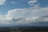
The Tweed and Southern Gold Coast regions had a few cells during the afternoon. Small, high based and low topped cells.


Location: Mcleans Ridges, NSW Northern Rivers
Australian Severe Weather:   http://australiasevereweather.com/
Lightning Photography:   http://www.lightningphotography.com/
Early Warning Network: http://www.ewn.com.au
Contact: Michael Bath