Author Topic: May 31 - June 02, 2007 - Tornado Alley  (Read 11460 times)

0 Members and 1 Guest are viewing this topic.

Offline Michael Bath

  • storm chaser
  • Administrator
  • Wedge tornado F5
  • *
  • Posts: 1,602
  • Gender: Male
    • Australian Severe Weather
May 31 - June 02, 2007 - Tornado Alley
« on: 02 June 2007, 01:07:37 AM »
Nice to see a moderate risk on this afternoon's convective outlook.   Good luck for those chasing.   Two tornado warnings are current for North Central Kansas.
Location: Mcleans Ridges, NSW Northern Rivers
Australian Severe Weather:   http://australiasevereweather.com/
Lightning Photography:   http://www.lightningphotography.com/
Early Warning Network: http://www.ewn.com.au
Contact: Michael Bath

Offline Jimmy Deguara

  • Australian and Tornado Alley storm chaser
  • Administrator
  • Wedge tornado F5
  • *
  • Posts: 2,218
  • Gender: Male
  • Storm Chaser since 1993, Tornado Alley 2001
    • Australia Severe Weather
Re: May 31 - June 02, 2007 - Tornado Alley
« Reply #1 on: 04 June 2007, 08:35:37 AM »
Hi,

Although not up for discussion, I am back here in Australia - another year gone in Tornado Alley.

Back on topic, the 31st May 2007 was a bonus event. In fact, that was a day I was able head off and was going to until Macca suggested for me to check models given there was great confidence for severe weather. When I did, I decided to hold off a day. The decision did not disappoint.

What we were able to intercept was a HP supercell beginning reasonably dry with a donut hole shaped structure. It already had a persistent funnel and rapid rotation. As the bases lowered and the storm maintained organisation, the storm produced brief tornadoes. For us though, the best tornado appeared out of the precipitation in the Oklahoma panhandle west of Guyman! Wow is all I could say - this tornado took on a rope appearance and then roped out. We got awesome timelapse: both on the sstorm scale rotation and the mesocyclone.

We got the tornado from the SE side - hazy cone shape becoming a horizonatal funnel. Some nice images and video. We also got quite interesing footage earlier of smoke from a grass fire being sucked in to the notch. Also got one photograph of ligtning with this smoke being sucked in.

We were in Guyman when the storm tried to cycle up once more and a serious warning was issued. The rotation was incredible. Once it gusted out, we headed for Shamrock to make the drive to Dallas easier.


Regards,

Jimmy Deguara
« Last Edit: 05 June 2007, 04:58:44 AM by Jimmy Deguara »
-------------------------------------
Australian Severe Weather
www.australiasevereweather.com

Australian Thunderbolt Tours
www.thunderbolttours.com

Phone  0408 020468  (International :  61  2  408 020468)

Offline Jimmy Deguara

  • Australian and Tornado Alley storm chaser
  • Administrator
  • Wedge tornado F5
  • *
  • Posts: 2,218
  • Gender: Male
  • Storm Chaser since 1993, Tornado Alley 2001
    • Australia Severe Weather
Re: May 31 - June 02, 2007 - Tornado Alley
« Reply #2 on: 05 June 2007, 05:20:30 AM »
Hi guys,

Although the day I left was not that productive, the 2nd June 2007 proved quite eventful for Tim Marshall and his crew! A 9 minute slow moving tornado was intercepted rainwrapped though. This was the Dimmit storm. The structure of all storms awesome apparently.

Regards,

Jimmy Deguara
-------------------------------------
Australian Severe Weather
www.australiasevereweather.com

Australian Thunderbolt Tours
www.thunderbolttours.com

Phone  0408 020468  (International :  61  2  408 020468)

Offline Jimmy Deguara

  • Australian and Tornado Alley storm chaser
  • Administrator
  • Wedge tornado F5
  • *
  • Posts: 2,218
  • Gender: Male
  • Storm Chaser since 1993, Tornado Alley 2001
    • Australia Severe Weather
Re: May 31 - June 02, 2007 - Tornado Alley
« Reply #3 on: 05 June 2007, 05:04:47 PM »
Final set of photographs from the 31st May 2007 event.

Beginning in Amarillo, we made out way to Dumas where we checked more data. It became apparent that a dryline bulge was setting up in the northern Texas panhandle. However, we only made our move when the first echos showed in extreme southeast Colorado. Making our way north, although the storms were severe warned, and echos looked decent, the updrafts indicated otherwise.
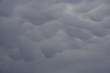
Mammatus


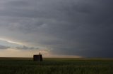
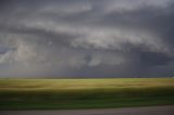
Proceeding to a vantage point under the anvil in the Oklahoma panhandle, we simply enjoyed the surroundings. Occasional bolts and brief periods of active phases attracted our interest. A couple of farmers came past for a chat almost unaware of the storms nearby.


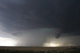
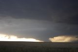
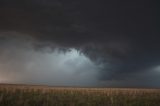
The lightning activity in particular cell the northwest became more frequent. Suddenly in the haze, the appearance of an high precipitation supercell structure emerged. Just as I reminded Brad that this is what it looked like way back on 27th May 2001, a tornado warning was issued for the cell. What surprised me was the doppler indications of rapid rotation!


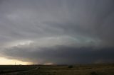
It merely took 10 minutes or so to be near the storm and in a position to film timelapse - across the border into extreme southeast Colorado. This was the start of a transition to a skeletal HP supercell phase to wet HP supercell. The structure consisted of a donut shape with precipitation core in the centre. But the funnel cloud persisted throughout with variations in shape and behaviour.


Finally as we made our way southeast and south, other chasers emerged from the north. I admit we did remain a little too long only to find out that our escape route was a muddy slick road. No option now except head into the rear flank downdraught and the core. This seemed endless despite the sunlight. The hailstones smacking the vehicle with ferocious winds did not make things comfortable.

Yes we were in this:


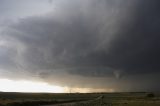
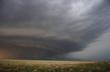
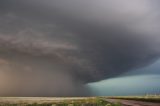
Once out of harms way, we were in chase mode once again. The storm had attained incredible structure - our aim to maintain an easterly vantage point with respect to the supercell.


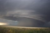
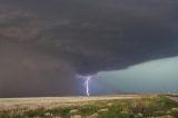
At one point, even the smoke from a grass fire was sucked into the inflow notch. And the lightning - it randomly pierced the earth from anywhere near the core to many miles out of the anvil - certainly kept us on alert with one eye on roaming.


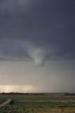
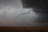
Finally, as we stepped with the storm east and on approach to Guyman, we noticed rapid inflow into the wall cloud region. Then, as we were concentrating on the wall cloud to our west, a cone within the precipitation was observed that began to take on a snake - funnel appearance. Our last day and another tornado! This tornado finally roped out after a few minutes.


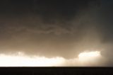
This phase may have been over, but I was shocked to note a warning was re-issued - this time an extremely dangerous and life threatening situation - the possibility of strong to violent tornadoes! And this was near Guyman - the circulation within few hundred metres. A funnel was observed but a ground circulation was difficult to confirm from our perspective.


Once the storm became outflow dominant, we made our way easy towards Canadian and then Shamrock for an easy trip to Dallas.

Regards,

Jimmy Deguara
« Last Edit: 07 June 2007, 10:37:04 AM by Jimmy Deguara »
-------------------------------------
Australian Severe Weather
www.australiasevereweather.com

Australian Thunderbolt Tours
www.thunderbolttours.com

Phone  0408 020468  (International :  61  2  408 020468)

Offline Michael Bath

  • storm chaser
  • Administrator
  • Wedge tornado F5
  • *
  • Posts: 1,602
  • Gender: Male
    • Australian Severe Weather
Re: May 31 - June 02, 2007 - Tornado Alley
« Reply #4 on: 06 June 2007, 01:29:11 AM »
What an awesome way to end your US adventures Jimmy and Brad. Beautiful awesome structures !!!  Looking forward to seeing some video over the quiet months here.

The catalog has been updated with Jimmy's full set of photos for this date:

http://australiasevereweather.com/photography/photos/2007/jd20070531.html

regards, Michael
Location: Mcleans Ridges, NSW Northern Rivers
Australian Severe Weather:   http://australiasevereweather.com/
Lightning Photography:   http://www.lightningphotography.com/
Early Warning Network: http://www.ewn.com.au
Contact: Michael Bath

Offline Jimmy Deguara

  • Australian and Tornado Alley storm chaser
  • Administrator
  • Wedge tornado F5
  • *
  • Posts: 2,218
  • Gender: Male
  • Storm Chaser since 1993, Tornado Alley 2001
    • Australia Severe Weather
Re: May 31 - June 02, 2007 - Tornado Alley
« Reply #5 on: 08 June 2007, 05:17:39 PM »
Thanks John - remember the subject are the storms - not the photographs. I see photography as a means to provide irreplacable memories:)

I would also like to take this opportunity to thank Brad Hannon for sacrificing his time in planning this trip. Often the background work, the incredible amount of research and efforts can go unnoticed but the rewards were there for all. Thanks Brad.

For those who did chase, 2007 will hopefully be a year they will remember!

Regards,

Jimmy Deguara
-------------------------------------
Australian Severe Weather
www.australiasevereweather.com

Australian Thunderbolt Tours
www.thunderbolttours.com

Phone  0408 020468  (International :  61  2  408 020468)