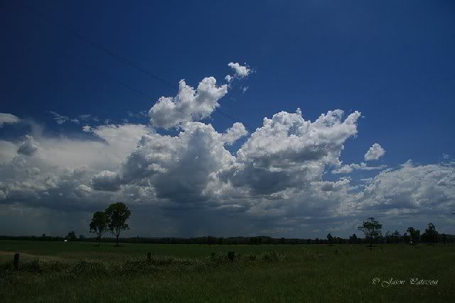
Author Topic: Storms NSW / QLD: 15 - 17 January 2009  (Read 17421 times)

0 Members and 1 Guest are viewing this topic.

Offline Antonio (stormboy)

  • Stove pipe F3
  • *
  • Posts: 481
  • Gender: Male
Storms NSW / QLD: 15 - 17 January 2009
« on: 17 January 2009, 05:18:17 AM »
16th January 2009

Now I know I've started this topic a little early but according to all weather forecasts we look to be getting a storm this afternoon. I hope anyway so lets hope one does develop throughout today. Here's the weather forecast for the NSW Northern Rivers:

Friday Partly cloudy. Fine in the morning. Isolated showers and thunderstorms developing in the afternoon. Light to moderate northeast to northwest winds fresh near the coast ahead of a southerly change overnight.

« Last Edit: 18 January 2009, 01:49:33 AM by Jimmy Deguara »

Offline Richary

  • Barrel tornado F4
  • *
  • Posts: 680
  • Gender: Male
RE: Storms NSW / QLD: 15 - 17 January 2009
« Reply #1 on: 17 January 2009, 02:49:39 PM »
16th January 2009

Nice bit of lightning and heavy rain over Woolgoolga this afternoon (about 7) talking to my friend there, and the radar showed another storm went just north of Port Macquarie earlier.

The storm that hit Woolgoolga briefly hit a black spot in the middle near Dorrigo, but had faded to light red by the time it got to the coast.
« Last Edit: 18 January 2009, 01:50:12 AM by Jimmy Deguara »

Offline Antonio (stormboy)

  • Stove pipe F3
  • *
  • Posts: 481
  • Gender: Male
RE: Storms NSW / QLD: 15 - 17 January 2009
« Reply #2 on: 17 January 2009, 04:43:29 PM »
16th January 2009

very right you are richary i was watching the radar since 5pm and now it is 10:40pm and some storms have been coming close to my location (Ballina) and a nice lightning display but im not sure if there will be any action like last week when we got a storm at midnight.
« Last Edit: 18 January 2009, 01:50:36 AM by Jimmy Deguara »

Offline Dave Nelson

  • Elephant Trunk F2
  • *
  • Posts: 172
  • Gender: Male
    • Stormy Sydney
RE: Storms NSW / QLD: 15 - 17 January 2009
« Reply #3 on: 17 January 2009, 05:08:52 PM »
15th January 2009

 Watch and photo'ed the towers start building from early afternoon onwards. I was in the Emerton area as temps
hit 43C. It was totally unbearable outside the vehicle, like standing in front of a blast furnace. The cells were
building in this general area of western Sydney and then moving eastwards. Two cells became larger and active
as and I followed them eastwards.

 One cell moved from the WNW towards the ESE and by the time it got over Nth Ryde area it was dropping CG's
and some heavy rain.  the second cell was moving more due easterly and started dropping rain and CG's from
~ Granville area and eastwards towards the Sydney CBD.

Other cells moved across from Campbelltown area and across Helensburgh and offshore, also others formed over
 the Hawkesbury area and moved NE over Gosford.  A number of other smaller ones came over home, in West Ryde
dropping brief bursts of heavy rain and some lightning.

None of the cells were well formed, ie. they lacked solid bases, not overly photogenic.

Temperatures dropped very rapidly as the southerly change hit and and it brought in fast moving low level cloud that
obscurred the higher level storm clouds.

Around 2000hrs EDT another cell came up from the SW and over the Ryde to Paramatta area dropping more rain
and was very lightning active, tho most of it was CC's lighting up the clouds without seeing the zaps.

Cheers
Dave N
« Last Edit: 18 January 2009, 11:50:32 AM by Dave Nelson »

Offline Jimmy Deguara

  • Australian and Tornado Alley storm chaser
  • Administrator
  • Wedge tornado F5
  • *
  • Posts: 2,218
  • Gender: Male
  • Storm Chaser since 1993, Tornado Alley 2001
    • Australia Severe Weather
RE: Storms NSW / QLD: 15 - 17 January 2009
« Reply #4 on: 17 January 2009, 06:51:43 PM »
15th January 2009

Dave,

I took the opportunity to use my farm as a base to photograph some of the cumulus and cumulonimbus around Sydney. Here are some of the images:


All photos for 15 January 2009
« Last Edit: 18 January 2009, 11:20:11 AM by Michael Bath »
-------------------------------------
Australian Severe Weather
www.australiasevereweather.com

Australian Thunderbolt Tours
www.thunderbolttours.com

Phone  0408 020468  (International :  61  2  408 020468)

Offline Antonio (stormboy)

  • Stove pipe F3
  • *
  • Posts: 481
  • Gender: Male
RE: Storms NSW / QLD: 15 - 17 January 2009
« Reply #5 on: 17 January 2009, 06:54:33 PM »
once again very nice basic pictures from jimmy i love the formation of cumulonimbus clouds especially when they reach anvil stage

Offline Jimmy Deguara

  • Australian and Tornado Alley storm chaser
  • Administrator
  • Wedge tornado F5
  • *
  • Posts: 2,218
  • Gender: Male
  • Storm Chaser since 1993, Tornado Alley 2001
    • Australia Severe Weather
RE: Storms NSW / QLD: 15 - 17 January 2009
« Reply #6 on: 17 January 2009, 07:07:45 PM »
Chase January 16 2009

More of a drive to the north coast and overnight stay, I let the sight seeing rule over the chasing today. The drier westerly winds were prominent in spoiling the party inland from the coast. Here are some images from today:


All photos for 16 January 2009
« Last Edit: 18 January 2009, 11:24:08 AM by Michael Bath »
-------------------------------------
Australian Severe Weather
www.australiasevereweather.com

Australian Thunderbolt Tours
www.thunderbolttours.com

Phone  0408 020468  (International :  61  2  408 020468)

Offline Harley Pearman

  • Barrel tornado F4
  • *
  • Posts: 584
RE: Storms NSW / QLD: 15 - 17 January 2009
« Reply #7 on: 18 January 2009, 03:18:50 AM »
Chase report 15 January 2009:

On Thursday 15 January 2009, I had a rostered day off and decided to head to the Southern Highlands town of Bowral to escape the expected 40C heat for Western Sydney to see what would happen during the afternoon.

Bowral sits 620 metres in elevation and it was cooler than Sydney being 36.6C just prior to the mid afternoon cool change.

Upon arriving at Bowral, I identified large clusters of alto cumulus castellatus clouds present in this region. After lunch, the cluster of cloud had drifted just to the north of town and I went to the top of Mt Gibraltar 863 metres in elevation. The temperature was 33C, still warm but allot more comfortable. One lookout faces the south and I could see all the way to the south coast. I was able to identify the southerly change moving north along the coast SE of me.

I then went to the northern lookout that gave me unprecedented views all the way to Sydney. I identified western Sydney baking under the 42C heat and a dome of polluted air (coloured light grey) engulfing the western suburbs of the city. The coastal suburbs were largely free of the pollution and the extreme heat.

In addition the cloud bank was approximately 20 km to my north by 2 pm but still south west of Sydney. Mid afternoon, the first high based thunderstorm cell slowly developed on that cloud bank to my north. The first storm cells developed as the southerly change closed in on Bowral.

By 3 pm, the southerly change reached Bowral and I left Mt Gibraltar and drove north to catch up with that cloud bank which I did. With the southerly change now behind me, I stopped at a roadstop near Bargo where I photographed a small high based thunderstorm cell directly in front of me. The storm produced a shower of rain and 2 thunderclaps before weakening.

Afterwards, the southerly change caught up with me but this time, I let it overtake me because I did not want to drive back into Sydney in 42C heat. Following the wind change, further small high based storm cells developed in the region north from Mittagong to south of Camden.

I waited a while before driving north towards Camden where I photographed another storm cell that produced another shower of rain and 10 thunderclaps.

Eventually I was able to photograph 3 storm cells by playing right on the southerly change boundary for some 100 km. I refused to enter into Sydney until the change had passed through mainly to avoid the excessive heat that had built up and polluted skies.

That worked to my advantage in which I was able to take my photos with the colouration's of the sky without having to worry too much about the heat and haze. It was a difficult day being out but in this situation, I was able to avoid the worst of the heat and I still managed to catch some high based thunderstorm cells by chasing right on the southerly change boundary.

I do have photos and expect to post them once I sort out an issue with posting my photographs. Regards


Harley Pearman

Offline Jason(pato)

  • Elephant Trunk F2
  • *
  • Posts: 136
  • Gender: Male
Re: Storms, 15th - 16th January 2009
« Reply #8 on: 18 January 2009, 04:44:15 AM »
January 16th 2009

Michael Bath and I decided to head out yesterday with the possibility of storms forming. Instability and shear was better further south around the southern Northern Rivers and Northern Mid North Coast area. An area of convection was apparent near Casino so we decided to investigate. Surprisingly a small cell had developed near Casino, so we decided to observe this for a while.


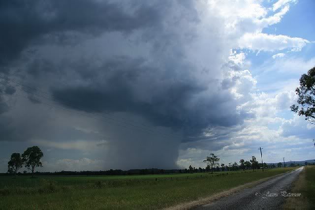
This proceeded to dump a pretty substantial microburst SW of our position, but with the lack of shear it collapsed on itself a little later on.


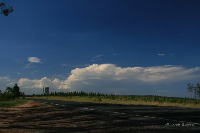
After watching this weaken we decided to head to our original target area around Grafton. We stopped near Whiporie to get an idea of what was going on. There was cells evident but nothing appeared very strong looking. The earlier cell looked nice to the north but after a radar check it was clear it was just about dead.


After standing in oppresive heat we decided to head south. We ended stopping near Junction Hill just north of Grafton to check out a cell that was to the west of Grafton. We noticed somebody setting up a camera just up the road from us so we decided to have a look and see who it was. It turned out it was Flip who had decided to come to the NR's to check out some of our storm action.
The cell near Grafton was spitting out some nice CGs and also had a microburst look to it. We hung here for about 30mins or so, but it looked like it had weakened so we moved back north again to Whiporie to grab a quick feed and consider our options.
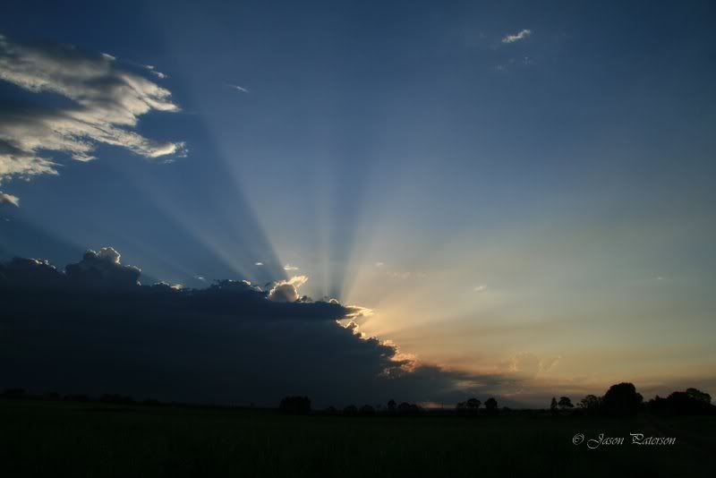
After a quick feed it looked like there was activity coming up from the south again so MB mentioned going to Lawrence which has great views over the water and provides a nice backdrop to any lightning that would occur. While waiting for dark to come we observed some impressive crespucular rays.


It seemed like ages before it got fully dark enough for the lightning to reveal itself, but soon enough it became visible although a bit distant.


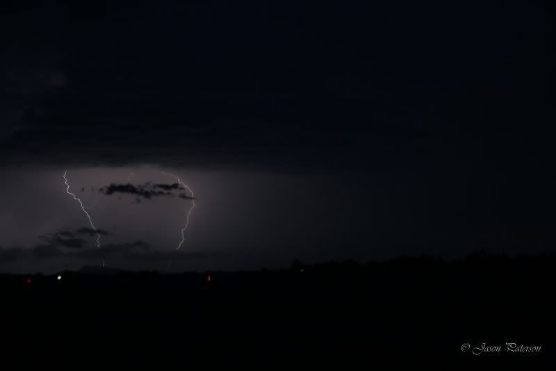
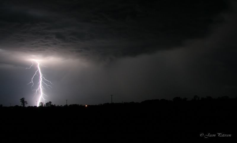
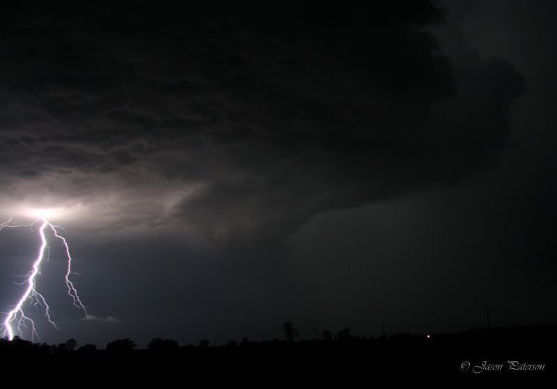
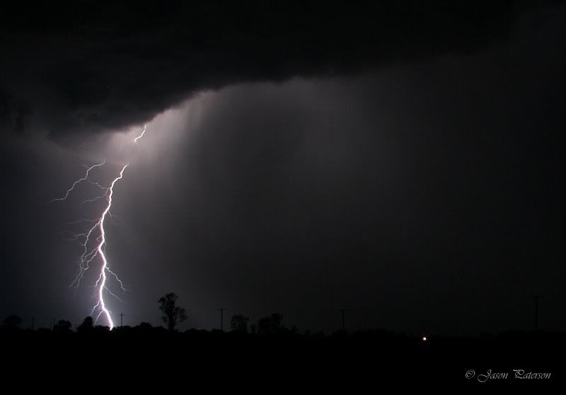
More lightning to our SW caught our attention so we decided to check this out. This looked far more impressive and closer so we looked for a place to set up. While we were looking a very bright stacatto smashed down ahead of us. This was what we had been waiting for. We set up and proceeded to click away watching the awesome show and commenting on the brilliance of the lightning. At one stage a bolt must have hit a transformer or telegraph pole as there was a crazy blue/green glow after the bolt touched down. Heres a selection of some of my better pics.


We watched the show for about an hr or more, before noticing more action to our NW so we decided to have a look at that. It was approaching the Whiporie area so we headed that way but rain forced even further north back towards Coraki and that is where we ended the chase watching the cell south of us move off the coast. Tried to get some pics of the retreating cell but had some issues of getting a decent focus so most of my pics turned out a bit blurry. Didn't really bother me that much as I had plenty to keep me satisfied from earlier in the evening.
In all a pretty good, but tiring, chase. Very happy with the outcome, with some nice cells in the afternoon followed by an awesome lightning show. Can't ask for more than that!
Big thanks to MB for driving, its always a pleasure to watch natures show with someone else.

Hope you enjoy,

Cheers Jason 
South Lismore, Northern Rivers NSW.....Supercells are us!!

Offline Antonio (stormboy)

  • Stove pipe F3
  • *
  • Posts: 481
  • Gender: Male
Re: Storms NSW / QLD: 15 - 17 January 2009
« Reply #9 on: 18 January 2009, 06:06:03 AM »
i was watching this cell on the radar it was just behind casino and it was small but it had a fear bit of color in it. as for us here in Ballina we got nothing but a little bit of distant lightning thats all

Offline Shaun Galman

  • Stove pipe F3
  • *
  • Posts: 441
  • Gender: Male
    • ridgelightning.com
Re: Storms NSW / QLD: 15 - 17 January 2009
« Reply #10 on: 18 January 2009, 10:51:39 AM »
Hi all,
Great captures Jason(pato) well done! Nice to see a good deal of base structure in those CG photos! It's nice to be rewarded after a not so decent afternoon's chasing (particularly when the temp's are up ni the high 30's - low 40's outside!)

Not a lot happening out this way? Just plenty of heat and dry hot winds lol.
Regards,
Shauno
Chasing Region: Lightning Ridge. N.S.W.
Website: www.ridgelightning.com

Offline Harley Pearman

  • Barrel tornado F4
  • *
  • Posts: 584
Re: Storms NSW / QLD: 15 - 17 January 2009
« Reply #11 on: 18 January 2009, 11:15:35 AM »
Storm chase 15th February 2009

Further to my earlier post, the photos below were taken from my storm chase on 15/1/2009 from Bowral to Camden.


Harley Pearman

Offline Michael Bath

  • storm chaser
  • Administrator
  • Wedge tornado F5
  • *
  • Posts: 1,602
  • Gender: Male
    • Australian Severe Weather
Re: Storms NSW / QLD: 15 - 17 January 2009
« Reply #12 on: 18 January 2009, 11:35:18 AM »
A couple of extra pics to compliment Jason's great chase report and photos. It was a long day but awesome to get out and enjoy the weather and conversation with Jase. By the end of the chase it seemed like the first cell southwest of Casino early arvo was a separate chase day - must have been the heat :-P


There was a really nice rainbow during our drive SE into Lawrence.


This sunset one is cropped a little:


MB
Location: Mcleans Ridges, NSW Northern Rivers
Australian Severe Weather:   http://australiasevereweather.com/
Lightning Photography:   http://www.lightningphotography.com/
Early Warning Network: http://www.ewn.com.au
Contact: Michael Bath