Author Topic: QLD & NE NSW Storms and Rain: 1 - 3 Jan 2009  (Read 17156 times)

0 Members and 1 Guest are viewing this topic.

Offline James

  • Elephant Trunk F2
  • *
  • Posts: 149
  • Gender: Male
    • Sydney Storm Chasers
QLD & NE NSW Storms and Rain: 1 - 3 Jan 2009
« on: 02 January 2009, 07:42:25 PM »
Ok so I may be out a day however a couple of photos from Toowoomba tonight of the developing storm that went on to become severe over SE QLD.

Good to get Dann amongst the QLD storms!

The Drive home from Bangalow to Mcleans Ridges was a little hairy with tree branches and leaf litter literally covering the road. Some big branches down towards Binna Burra.


« Last Edit: 02 January 2009, 07:47:27 PM by James »

Offline Michael Bath

  • storm chaser
  • Administrator
  • Wedge tornado F5
  • *
  • Posts: 1,602
  • Gender: Male
    • Australian Severe Weather
RE: QLD & NE NSW Storms and Rain: 1 - 3 Jan 2009
« Reply #1 on: 03 January 2009, 03:07:52 AM »
Nice lightning James :)

The moisture return from the day before was pretty incredible. Dew points were single digits on the 31st Dec, back to 15 by yesterday morning (1st Jan) and then up to 25 !! by mid to late afternoon !   Certainly one of the most oppressive days I can recall given the temp was 32-34 at the same time - certainly Darwin like.  Yet most of the day had a cirrostratus cover - those sort of days always seem more humid than sunny days with similar temp/DP.

A lot of thunderstorm activity eventually spread into the Northern Rivers with a severe thunderstorm warning issued just after 10pm. Storms were moving and developing towards the ESE so had a great view from home of the lightning and structure.

Will put up some pics soon.

There was a roar from the west for several minutes before the storm hit here (McLeans Ridges). Doppler radar showed some very strong winds so I knew it was going to be interesting when it hit!  Sure enough, gusts around 100km/h blasted through followed by bursts of heavy rain and a barrage of CGs. Stuff went flying. The AWS measured a gust of 67km/h at 23:39 - the strongest gust I've measured in 7 years!  It under-records by 50% so we easily had winds in the 100-110km/h range.

Not surprised you came across debris James.

Quote
Storms taking toll on NSW north coast

Friday January 2, 2009 - 08:02 EDT

The State Emergency Service says volunteers are starting to feel the effects of the recent wild weather.

The New South Wales north coast region was battered overnight by the fourth violent storm in 10 days.

The Richmond-Tweed SES deputy controller, Jeff Spash, says volunteers worked until about 3:00am AEDT this morning in some places, and will soon be back on the job.

He says the damage was widespread.

"Kyogle, a house there with half its roof off, Woodburn, trees over vehicles in the caravan parks, Murwillumbah had another half a roof off a house in Tyalgum, and Mt Lindsay, a heap of trees blocking the highway there about three kilometres west of Woodenbong," he said.

"In Macleans Ridges there was a fairly big tree down near a house there."

- ABC
« Last Edit: 03 January 2009, 03:13:50 AM by Michael Bath »
Location: Mcleans Ridges, NSW Northern Rivers
Australian Severe Weather:   http://australiasevereweather.com/
Lightning Photography:   http://www.lightningphotography.com/
Early Warning Network: http://www.ewn.com.au
Contact: Michael Bath

Offline Michael Bath

  • storm chaser
  • Administrator
  • Wedge tornado F5
  • *
  • Posts: 1,602
  • Gender: Male
    • Australian Severe Weather
RE: QLD & NE NSW Storms and Rain: 1 - 3 Jan 2009
« Reply #2 on: 03 January 2009, 04:47:38 AM »
Brisbane radar loops 4pm to 1am EDT

---> Brisbane 128km scale radar loop

---> Doppler radar loop

---> Brisbane 256km scale radar loop (3pm to 2am)


Some pics from McLeans Ridges - times are EDT. Upper trough sure did the trick with 500 temps dropping from -9.5 to -12 over the Northern Rivers between 06z and 12z.


10.48pm

11.12

11.17

11.23

11.31

11.34

11.38

midnight
« Last Edit: 03 January 2009, 07:06:21 AM by Michael Bath »
Location: Mcleans Ridges, NSW Northern Rivers
Australian Severe Weather:   http://australiasevereweather.com/
Lightning Photography:   http://www.lightningphotography.com/
Early Warning Network: http://www.ewn.com.au
Contact: Michael Bath

Offline Antonio (stormboy)

  • Stove pipe F3
  • *
  • Posts: 481
  • Gender: Male
RE: QLD & NE NSW Storms and Rain: 1 - 3 Jan 2009
« Reply #3 on: 03 January 2009, 05:38:56 AM »
we sure got whipped by the storm last night here in Ballina heres a video showing the wind, heavy rain and lots of lightning

http://au.youtube.com/watch?v=bERxHeSBxYk

here are a few pics also
« Last Edit: 03 January 2009, 06:26:12 AM by stormboy »

Offline Jason(pato)

  • Elephant Trunk F2
  • *
  • Posts: 136
  • Gender: Male
RE: QLD & NE NSW Storms and Rain: 1 - 3 Jan 2009
« Reply #4 on: 03 January 2009, 05:55:40 AM »
Gday All,

Rodney Wallbridge and I decided to make the journey over the border in anticipation of a quality lightshow. Our target was the Warwick area so we headed off around 2.30pm. At this stage can I say that the road between Legume and Woodenbong is quite possibly one of the most ordinary I've been on. It is so bumpy and rough Rod and I felt like a couple of those wobbly dogs you see on the rear parcel shelf of cars, such was the way our heads were rolling on our shoulders from that horrendous rd. Any way back to the report.
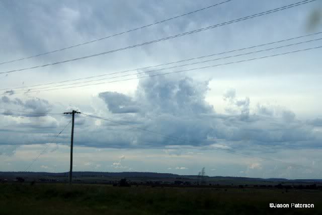
On the way there was some struggling convection but things would turn for the better later on.


We met up with Julian and his partner Jodie in Warwick and played the waiting game.  We decided to have an early bite to eat and wait for the main show to start. After knocking down some KFC (chasers choice I've been led to believe) we strolled outside to see a nice little cell to the east, so we decided to investigate. It was quite a high based cell but did drop a few CGs and did appear to have some scud under the main updraft at times.


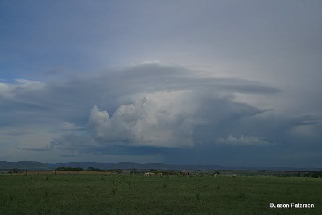
Another high based cell started to kick off to our south as well which was quite photogenic in the setting sun


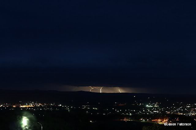
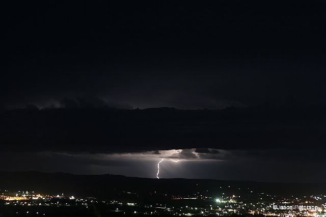
As soon as the sun had gone behind the clouds we could make out a line of storms to our west. We decided to make our way to an estate near the lookout over Warwick and wait for the line to approach. We didn't have to wait long as once the light started to fail distant CGs became visible. This is what we were waiting for. A quick consultation of the radar showed there was lots activity so all we had to do was wait for it to come to us. Once the line got a bit closer we got the cameras out and tried our luck. This was the best of mine with plenty landing just out of frame (typical)


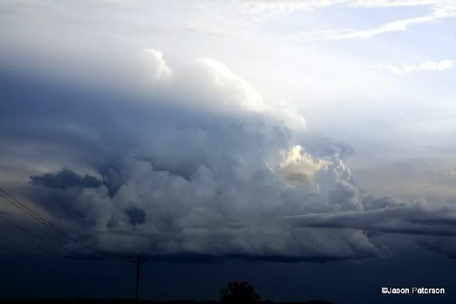
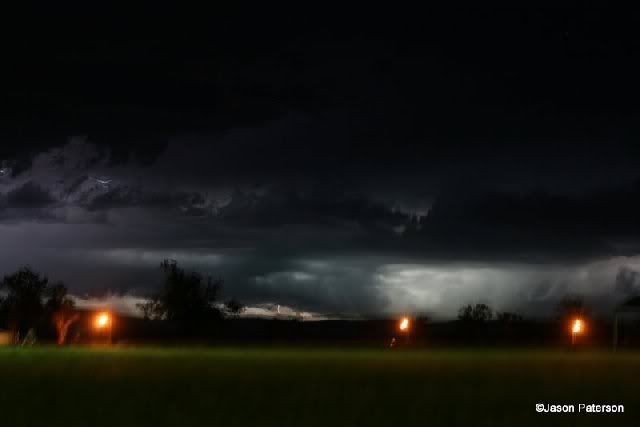
Not long after this some flashing to the north of us caught our attention from new development, so we turned our cams in this direction to try and capture some of the quality stacattos that were happening. Unfortunately at this stage the wind came up very strong, whether it was outflow from the earlier storm or inflow into this new storm I couldn't tell but it certainly intensified this new cell into something to behold. The wind was so strong that it was difficult to get a decent shot, with the tripod shaking around continually. The structure of the new cell was breathtaking with a very nice guster which looked to be scraping the hilltops. I tried to capture the scene as best as I could but the wind was making things next to impossible to get a quality image. Heres the best I could do.


Hopefully Rod or Julian got a better shot than this as it was truly spectacular to witness. Not long after this the rain started so we decided to make our way to the cars and consider our options. Julian let us know that the cell was making its way towards Lismore so we decided to call it a night and head home in anticipation of catching up to it and getting some more pics.

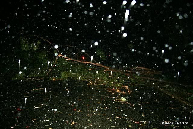
Thankfully we didn't catch up with it because the road home was constantly littered with leaf debris and small branches. As we made our way towards Woodenbong the size of branches lying on the sides of the road increased in size until inevitably we came across the very thing we didn't want to see.......a group of 5 trees were lying the full width of the Mt Lindesay Hwy about 5km west of Woodenbong blocking our way home. I'm sure glad we didn't catch up with the cell as it would have been a very scary, if not bloody dangerous area to have been in as it is heavily forested and the prospect of a tree landing on Rods car wasn't my cup of tea.

Heres a pic of the scene sorry about quality it was still raining moderately as you can see.


We had a semi in front of us who told us that he had called someone about the HWY being blocked, but an 1 1/2 hrs later no-one had turned up. So Rod got on the phone to the SES after hrs officer and had someone organised to get up and clean up the road. Finally after 2hrs the road was passable and we were on our way. The next 30kms were a slow grind as we had to constantly keep our eyes peeled for more trees. Thankfully the council had already been out and cleaned up. The size of some of the trees cleared to the side of the road was incredible. It must have really roared through that area.

We finally got back to Lismore at 3.30am......13hrs after we started the chase. I was very exhausted, I couldn't imagine how Rod felt, it was a Herculean effort and I can't thank him enough for getting me home safe and sound.

In all a pretty satisfying day although I didn't get as many quality photos as I would have liked but thats the nature of chasing. It was great to meet and chase with Julian, I 'm sure we'll cross paths again.

Anyway thats it (sorry if its a bit long winded),

Hope you enjoy,

Cheers Jason
« Last Edit: 03 January 2009, 06:15:28 AM by Jason(pato) »
South Lismore, Northern Rivers NSW.....Supercells are us!!

Offline Antonio (stormboy)

  • Stove pipe F3
  • *
  • Posts: 481
  • Gender: Male
RE: QLD & NE NSW Storms and Rain: 1 - 3 Jan 2009
« Reply #5 on: 03 January 2009, 06:01:01 AM »
jason that second or third picture looks really good nice job with the lightning snapshots to

Offline Rodney Wallbridge

  • Multi-vortex F1
  • *
  • Posts: 71
  • Gender: Male
    • Red Bubble
RE: QLD & NE NSW Storms and Rain: 1 - 3 Jan 2009
« Reply #6 on: 03 January 2009, 06:42:47 AM »
Gyday all, after finally getting home just before 4am this morning from Warwick.Large trees blocking the road 5k's west of Woodenbong delayed our travel time extensively. Jason Pato and myself met up with Julian and Jodie in Warwick yesterday arvo and watched a few storms around the region. AT one stage there were storms 300 degrees around us which was quite nice. The nature of the storms pushed gutsy outflows which spawned new updrafts everywhere.
We had a nice veiw of the Big cell which pass near toowoomba and proceeded SE past us to the east. I am glad we didn't attempt to stay in front of it as it would have gobbbled us up in the slow winding parts of our home route....
Here are a few pics from our vantage point! was an enjoyable relaxing chase!We welcome 2009 with a chase on the first day!!


Offline Richary

  • Barrel tornado F4
  • *
  • Posts: 680
  • Gender: Male
RE: QLD & NE NSW Storms and Rain: 1 - 3 Jan 2009
« Reply #7 on: 03 January 2009, 01:23:19 PM »
Some nice north coast and SE Qld storms in that lot. Nothing forecast for Sydney (until Monday night - guess who flies to Perth that morning!).

Hope my friend from Coffs is enjoying her camping trip out near Deepwater with all that going on.

leo76

  • Guest
RE: QLD & NE NSW Storms and Rain: 1 - 3 Jan 2009
« Reply #8 on: 03 January 2009, 05:01:46 PM »
Great photos everyone.

So much for getting an early nights sleep. Husband came in to tell me he was off to try and take some shots. So then I stayed up to watch the light show - so easy when you have ceiling to floor glass doors in your bedroom. Now to try and persuade the landlord to maybe knock a few meteres off the trees in the back...


Wazza

  • Guest
RE: QLD & NE NSW Storms and Rain: 1 - 3 Jan 2009
« Reply #9 on: 04 January 2009, 02:30:43 AM »

can I say that the road between Legume and Woodenbong is quite possibly one of the most ordinary I've been on. It is so bumpy and rough Rod and I felt like a couple of those wobbly dogs you see on the rear parcel shelf of cars, such was the way our heads were rolling on our shoulders from that horrendous rd.


hehe I'd have to agree with you there Pato, I've been out there on my Motorbike and thought the suspension was going to collapse. Worse road i've ever been one. Gravel roads are in better condition than this one.
One road anyone should try to stay clear of thats for sure.

Waz

Wazza

  • Guest
RE: QLD & NE NSW Storms and Rain: 1 - 3 Jan 2009
« Reply #10 on: 04 January 2009, 02:36:12 AM »
we sure got whipped by the storm last night here in Ballina heres a video showing the wind, heavy rain and lots of lightning

After driving around Lismore,Alstonville & Ballina Yesterday morning Ballina didnt seem to have any damage at all.
Worst areas seem to be from Goonelabah to the Alstonville-Ballina Cutting. Lots of trees down in Alstonville Teven Rd to Ballina cutting.
Powerlines where down on Teven Rd Alstonville.
No pictures sorry, Left the Camera at home.

Offline James

  • Elephant Trunk F2
  • *
  • Posts: 149
  • Gender: Male
    • Sydney Storm Chasers
RE: QLD & NE NSW Storms and Rain: 1 - 3 Jan 2009
« Reply #11 on: 04 January 2009, 03:19:28 AM »

can I say that the road between Legume and Woodenbong is quite possibly one of the most ordinary I've been on. It is so bumpy and rough Rod and I felt like a couple of those wobbly dogs you see on the rear parcel shelf of cars, such was the way our heads were rolling on our shoulders from that horrendous rd.


hehe I'd have to agree with you there Pato, I've been out there on my Motorbike and thought the suspension was going to collapse. Worse road i've ever been one. Gravel roads are in better condition than this one.
One road anyone should try to stay clear of thats for sure.

Waz

No arguments from me there. I only drove that road for the first ever time in December wanting to get out to Warwick from Kyogle for some storms. I remember asking MB about the road in which his reply was along the lines of "Tell me what you think of it". My response on returning "The worst road I think I have ever driven in Australia".  It is quite dangerous in parts with some serious bumps in and out of sharp corners leading to bouncing suspension at the moment you need to turn. In the wet it's even worse.

Will the road ever be re-done? I highly doubt it.

Offline Michael Bath

  • storm chaser
  • Administrator
  • Wedge tornado F5
  • *
  • Posts: 1,602
  • Gender: Male
    • Australian Severe Weather
Re: QLD & NE NSW Storms and Rain: 1 - 3 Jan 2009
« Reply #12 on: 06 January 2009, 03:15:49 AM »
Glad everyone is enjoying the Woodenbong to Legume Road LOL
I don't mind it as an adventurous drive, it's just a pain when you want to get somewhere quickly.


North-west remains cut off by rising floodwaters

Quote
Residents in north-west Qld had little warning.
Roads remain cut and a number of people have been airlifted to safety in Queensland's north-west as floodwaters continue to rise.

After more than four days of rain, rivers that were dry for most of last year have broken their banks.

In Mount Isa, most bridges that are not blocked by fast running water have piles of branches and debris on them, however the city itself is not expected to flood.
The Mount Isa rescue helicopter service has been kept busy over the past four days carrying out rescues and evacuations in outlying properties.

Chief executive Alex Doore says residents had little warning.

"I think it's probably caught a lot of people by surprise - I don't think people have seen this sort of wet for a little while," he said.

"People aren't realising how bad the roads are and how quickly the floodwaters are coming up around the place.
"We've never seen the creeks and rivers flowing as they are at the moment, so from the air [it is] very spectacular, but maybe people just need to check the conditions before they head out."

Roads to several other towns, including Julia Creek and Cloncurry, are also cut.

The weather bureau says it has been five years since the north-west region had such a good start to the wet season, with more than 400 millimetres falling at Gereta Station, north of Cloncurry, in the past four days.
The rain is expected to ease today.

-ABC


More news feeds available here


Location: Mcleans Ridges, NSW Northern Rivers
Australian Severe Weather:   http://australiasevereweather.com/
Lightning Photography:   http://www.lightningphotography.com/
Early Warning Network: http://www.ewn.com.au
Contact: Michael Bath