Author Topic: NSW / QLD / VIC Storms (incl Nimmitabel tornado and other supercells): 22-26 Dec 2008  (Read 80601 times)

0 Members and 1 Guest are viewing this topic.

Offline Michael Bath

  • storm chaser
  • Administrator
  • Wedge tornado F5
  • *
  • Posts: 1,602
  • Gender: Male
    • Australian Severe Weather
Thanks Ian - be great if you can get hold of those images. Most of the newer phones come with a USB cable to get them onto a PC. There was an amazing amount of turbulence and motion in the clouds - which were almost on the ground.

There were lots of rescue vehicles around after that major event and the other storms. A semi-trailer jack-knifed on the western side of the Leycester Hill on the Lismore Kyogle Road though it was not blocking traffic.

Michael

Location: Mcleans Ridges, NSW Northern Rivers
Australian Severe Weather:   http://australiasevereweather.com/
Lightning Photography:   http://www.lightningphotography.com/
Early Warning Network: http://www.ewn.com.au
Contact: Michael Bath

Offline Michael Thomas

  • Elephant Trunk F2
  • *
  • Posts: 172
  • Gender: Male
That Kyogle storm yesterday was quite impressive, great photos! Would be interesting to see these pictures of the possible tornado. Rotation was very obvious on the doppler and going by the structure, both visually and by radar, I would agree that it was a HP supercell.

Today is also shaping up nicely for SE Qld. Looking at forecast soundings for SE Qld I would have to guess that again there is sufficient shear and CAPE for supercells. I don't quite believe the extremely low LCL's that GFS is forecasting though. Will be interesting to see the Brisbane sounding. Hopefully there is a bit of a cap in place to hold of convection till later. Could see quite high CAPE if this occurs as the 500mbar temps are forecast to drop to around -10/11 this afternoon.

Michael

Offline Michael Thompson

  • Multi-vortex F1
  • *
  • Posts: 57
Great pictures all, and a good move by Jimmy to spend Christmas in the Northern Rivers.

In regards to the Cooma / Nimmitabel cell I am surprised that the Canberra chasers did not head south, it was only 90mins from them. I guess heading south is a psychological barrier.

I myself had targeted Bungonia/Marulan, but when I awoke to popcorn convection I immediately adopted a wait and see mode and in hindsight this was wise as I never put in a single wasted kilometre for what would have ended up with a bust chase (finances did not stretch to an extended chase beyond say Goulburn)

I could post of photo of the brief drizzle we had here in the Illawarra yesterday, but somehow I feel it will not raise too much excitement.

Offline Jimmy Deguara

  • Australian and Tornado Alley storm chaser
  • Administrator
  • Wedge tornado F5
  • *
  • Posts: 2,218
  • Gender: Male
  • Storm Chaser since 1993, Tornado Alley 2001
    • Australia Severe Weather
Hi,

"A particularly severe thunderstorm cell has been detected to the south of Grafton, with data from weather indicating it could produce very large hailstones. This cell is likely to pass very close to Grafton city around or shortly after 3pm."

This warning and the special warning from the Queensland Bureau of Meteorology were quite interesting. Michael, have you got that message from the Queensland Bureau about it being a particularly dangerous storm? Both to me indicate supercell status.

Michael T, even if you were from Canberra there was little time to get that tornado as it seemed to develop very early on the storms life. I find that extraordinary as this is something usually a feature in Tornado Alley.

Regards,

Jimmy Deguara
-------------------------------------
Australian Severe Weather
www.australiasevereweather.com

Australian Thunderbolt Tours
www.thunderbolttours.com

Phone  0408 020468  (International :  61  2  408 020468)

Offline Steven

  • Global Moderator
  • Stove pipe F3
  • *
  • Posts: 410
  • Gender: Male
Xmas day storms are a bit of a letdown today. Thanks too all that low-mid level junk cloud, it put a lid on development because the temp was too low (26-27 throughout the day). Now that the cloud has begun clearing, is the temp starting to creep back up again but not enough for convective heating. And all those storms to the west? Certainly aren't moving anywhere. I think we have to contend with poor sheer today, sorry to say.

Offline Michael Bath

  • storm chaser
  • Administrator
  • Wedge tornado F5
  • *
  • Posts: 1,602
  • Gender: Male
    • Australian Severe Weather
Yep - these are the warnings from the QLD boM for the 24th Dec (times are one hour behind NSW):

Quote
The Bureau of Meteorology warns that, at 2:40 pm, very dangerous thunderstorms were detected on weather radar near the area south of the NSW border. Thunderstorms are moving towards the east to northeast. Very dangerous thunderstorms are forecast to affect the McPherson Range, Springbrook and Little Nerang Dam by 3:40 pm.

and this second one. The associated threat maps had that cell marked as well

Quote
The Bureau of Meteorology warns that, at 3:20 pm, very dangerous thunderstorms were detected on weather radar south of the NSW border. Thunderstorms are moving towards the east to northeast. Very dangerous thunderstorms are forecast to affect the McPherson Range and Springbrook by 3:50 pm, and Coolangatta, Miami and Mudgeeraba by 4:20 pm.
Location: Mcleans Ridges, NSW Northern Rivers
Australian Severe Weather:   http://australiasevereweather.com/
Lightning Photography:   http://www.lightningphotography.com/
Early Warning Network: http://www.ewn.com.au
Contact: Michael Bath

Offline Michael Bath

  • storm chaser
  • Administrator
  • Wedge tornado F5
  • *
  • Posts: 1,602
  • Gender: Male
    • Australian Severe Weather
More info about the tornado which was photographed halfway between Cooma and Nimmitabel by Heather Leckie

---> Canberra Times report

---> Google Maps location

Location: Mcleans Ridges, NSW Northern Rivers
Australian Severe Weather:   http://australiasevereweather.com/
Lightning Photography:   http://www.lightningphotography.com/
Early Warning Network: http://www.ewn.com.au
Contact: Michael Bath

Offline Michael Thompson

  • Multi-vortex F1
  • *
  • Posts: 57

Michael T, even if you were from Canberra there was little time to get that tornado as it seemed to develop very early on the storms life. I find that extraordinary as this is something usually a feature in Tornado Alley.


Jimmy Deguara

That is true, but the persistence of the black core would have rewarded a Canberra chaser who took off south with something worth pointing the camera at. While I am pretty sure this was probably the only tornado from the storm, the mesocyclone may have been quite visible a couple of hours later still.

Offline Jimmy Deguara

  • Australian and Tornado Alley storm chaser
  • Administrator
  • Wedge tornado F5
  • *
  • Posts: 2,218
  • Gender: Male
  • Storm Chaser since 1993, Tornado Alley 2001
    • Australia Severe Weather
Hi guys,

Took my family across the border for their first trip to Queensland today via Boonah and then Warwick. I saw the storm to the south and stuff to the west and north west. I did not like the long drive so opted to the nice looking cell down south near Tenterfield at the time. Obviously I confirmed with Michael Bath as per usual to ensure fuel is not wasted.

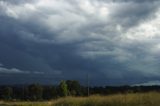
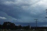
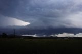
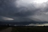
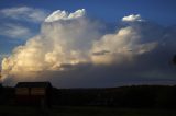
As I approached Stanthorpe, Imelda had to control me driving as I began to go crazy at the impending structure! I know for a fact that I missed out on the best and the images below only show a weakening phase. I only need 10 or so minutes and it would have been all fine.

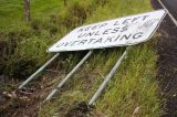
The first two photographs are damage from the Kyogle cell yesterday 24th December 2008:


Tenterfield severe storm:


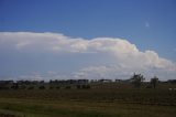
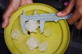
Hailstones maximum was near golf ball


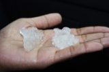
Strangely enough - Kimberly (at 12 years of age) commented after yesterday's storm that she wanted hail - "we get rain in the Philippines"! So hail she got today and she really enjoyed! It was really a pleasant chase but I can assure you, I went hard at one stage to get into the hail once more and succeeded without knowledge of the region and no maps.

All photos for 25 December 2008


Regards,

Jimmy Deguara
« Last Edit: 27 December 2008, 02:54:35 AM by Michael Bath »
-------------------------------------
Australian Severe Weather
www.australiasevereweather.com

Australian Thunderbolt Tours
www.thunderbolttours.com

Phone  0408 020468  (International :  61  2  408 020468)

Offline Michael Bath

  • storm chaser
  • Administrator
  • Wedge tornado F5
  • *
  • Posts: 1,602
  • Gender: Male
    • Australian Severe Weather
This funnel photo was taken by Scott Hills on his phone camera 25th Dec @ 2.33pm. Pic taken looking north from the intersection of Invercauld Road and Ballina Road, Goonellabah.

There was a lot of cumulus about 2-3ks deep from the NE during yesterday.


Location: Mcleans Ridges, NSW Northern Rivers
Australian Severe Weather:   http://australiasevereweather.com/
Lightning Photography:   http://www.lightningphotography.com/
Early Warning Network: http://www.ewn.com.au
Contact: Michael Bath

leo76

  • Guest
Oh you are joking me!!! I completely ignored my partner when he said, "look at that cloud over there...looks like its rotating"

HUGE forehead slap for me and well done to Scott.

Offline Jason(pato)

  • Elephant Trunk F2
  • *
  • Posts: 136
  • Gender: Male
Gday All,

Sorry for the lateness of this post but this is the first time at the PC since the 24th Dec cause I've been at the in-laws house with limited internet access.

The following pics are of the storm that went over the Lismore region on the 24th December. I couldn't get over the impressive structure. For all its fierce looking nature it only delivered some heavy rain and some gusty winds at our location (near the Channon NW of Lismore).


And a nice double rainbow to finish the show


Hope you enjoy,

Cheers Jason
South Lismore, Northern Rivers NSW.....Supercells are us!!

Offline Brad Hannon

  • Thunderbolt Tours Group
  • Stove pipe F3
  • ******
  • Posts: 427
  • Gender: Male
  • Colorado Beast - 2nd June 2005


I totally agree with your comment about the structure Jason.  Congrats on being there to see it in the flesh and despite hills and trees you got some great shots.
hmmm June 2nd......

Offline Ben

  • Multi-vortex F1
  • *
  • Posts: 34
  • Gender: Male
Fantastic photos James and Jimmy!!! I was at Coonabarabran on the 26th. Got a rather decent pulse storm. It looked good, weakened, I left it, got another pulse storm, and then rechased the other one!! It dropped a funnel and much to my surprise gave me 3-4cm hail in the Warrumungles (close to the Mudgee size) - the 800m elevation probably aided the size a bit.
Cropped funnel
     
Guster passing off to east
   
Hail, using the ruler on hand measurement it was ~4cm this stone, due to it being jagged. Most of the larger ones were around 3cm at most (though round not jagged). 
   
Rest of photos can be found at http://www.flickr.com/photos/28009095@N05/ 

Offline Ben

  • Multi-vortex F1
  • *
  • Posts: 34
  • Gender: Male
!I finally have gotten time to at least get through footage of the 23rd December Mudgee supercell. Will do a brief report.
Started out day at Bathurst with Shane. Only met up briefly before i decided to go north (mostly cos of needing to be at Dubbo) and him south. Got to Mudgee to see what I thought was an ordinary pulse storm just north of town.. no CG's at all. Booted up wireless to see a black core instead so I was going ***!! Quickly became obvious had to go towards Cassilis to get ahead. Ran into some golf ball size hail after taking this road before finally getting just ahead of it.. Didn't last long before the hail returned!!
Footage of golf ball size hail near Mudgee (1 min 51 sec) BEWARE LOTS OF SWEARING!
 http://www.youtube.com/watch?v=37OqHeHFALk
Got caught in the core again and suddenly hit a crazy cover of hail and nearly slid of the road + strong winds and crazy rain, couldn't see. After a good 15 minutes I finally got out of it and got ahead.. to reveal a nice meso.
   
Pushed self further towards Cassilis again. Low on fuel so headed towards town shortly after snapping more photos of the meso that appeared to be weakening.
   
got to Cassilis and asked for fuel at the bar as no servos. Before the guy could help me (was getting fuel out of the shed) the storm hit and I was trapped in there without the video camera.. as windows got smashed and blown out in the pub and the shed I was in was unrooved tragically.. Couldnt go outside the hail was coming down with a huge force. It settled down and I could finally get the aftermath.
Video of aftermath + structure in Cassilis (2 min 38 sec)
 http://www.youtube.com/watch?v=JEJhcGx6hLU (more swearing)

All pics here  http://www.flickr.com/photos/28009095@N05/

Coonabarabran funnel + hail
http://www.youtube.com/watch?v=hmiiPymjfpA
« Last Edit: 29 December 2008, 06:56:56 PM by Ben »