|
Recent and Historical Tropical Cyclones
Tropical cyclones, hurricanes and typhoons for Australia and the Southern Hemisphere developed by Michael Bath.
|
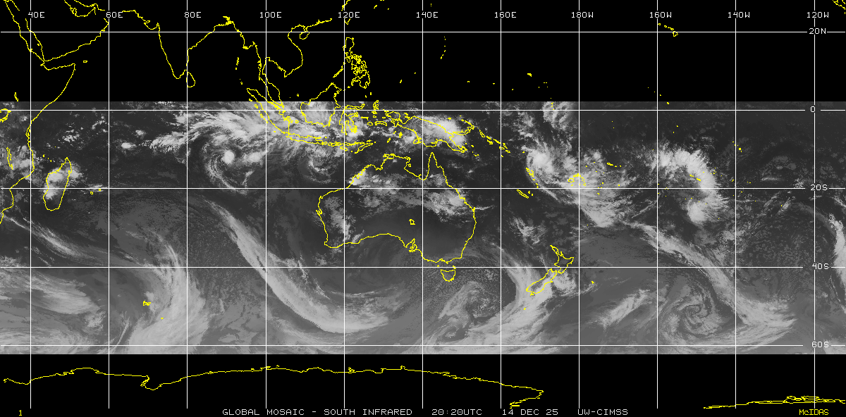
Click the satellite picture for a larger view of the South Indian Ocean, South Pacific Ocean and Australian region. On 1 March 2025 Google Maps substantially reduced the free tiers for Maps API. You may see the cyclone maps show errors or be removed as a result. If anyone would like to assist through advertising, please email Michael Bath. |
2023/24 season
Tropical Cyclone tracking maps issued by BoM
2024/25 Season
Errol, [9 - 18 Apr 2025]
- BoM Track
Dianne, [26 - 30 Mar 2025]
- BoM Track
Courtney, [22 - 29 Mar 2025]
- BoM Track
Alfred, [21 Feb - 9 Mar 2025]
- BoM Track
Bianca, [18 - 27 Feb 2025]
- BoM Track
Zelia, [8 - 14 Feb 2025]
- BoM Track
Vince, [31 Jan - 4 Feb 2025]
- BoM Track
Taliah, [31 Jan - 12 Feb 2025]
- BoM Track
Sean, [17 - 22 Jan 2025]
- BoM Track
Robyn, [23 Nov - 1 Dec 2024]
- BoM Track
2023/24 Season
Paul, [9 - 12 Apr 2024]
- BoM Track
Olga, [4 - 11 Apr 2024]
- BoM Track
Megan, [14 - 21 Mar 2024]
- BoM Track
Neville, [7 - 25 Mar 2024]
- BoM Track
Kirrily, [14 - 25 Feb 2024]
- BoM Track
202324_06, [31 Jan - 13 Feb 2024]
- BoM Track
Kirrily, [17 - 26 Jan 2024]
- BoM Track
Anggrek, [12 - 25 Dec 2023]
- BoM Track
Jasper, [2 - 18 Dec 2023]
- BoM Track
Region Advisories and Notes:
Bureau of Meteorology (BoM) Data
Season Summary and Individual
Tropical Cyclone Track Maps
Summary listing of all BoM tropical cyclones
| BoM: Australia 90E - 160E |
|---|
Historical Tropical Cyclone Track Maps
Joint Typhoon Warning Center (JTWC) Best Track Data
Season Summary and Individual
Tropical Cyclone Track Maps
Summary listing of all JTWC tropical cyclones
| JTWC: Australia 90E - 180E |
|
|---|---|
| JTWC: South Indian Ocean 15E - 135E |
|
| JTWC: South Pacific Ocean 135E - 110W |
|
| JTWC: Southern Hemisphere 15E - 110W |
Operational Data
Cyclone Track Maps since the 1997/98
season to December 2025.
 Feb 2026: Tropical cyclone tracks based on operational warnings issued by the various southern hemisphere warning agencies. Season and individual tracks are available from 1997/98 to Dec 2026 (896 cyclones).
Summary listing of all Operational tropical cyclones
| OPER: Australia 90E - 180E |
|
|---|---|
| OPER: South Indian Ocean 15E - 135E |
|
| OPER: South Pacific Ocean 135E - 110W |
|
| OPER: Southern Hemisphere 15E - 110W |
Information about the Southern Hemispshere basins and tropical cyclone intensities are available here.
Global Tracks and Summaries
Individual tropical cyclone event descriptions/overviews and operational track source data prepared monthly by Gary Padgett and Steve Young.
- Latest operational global tracks: May 2026
- Global Archives: September 1997 to date
View the Plotting Notes which define the southern hemisphere warning regions, and compare the Australian tropical cyclone intensity scale with the US Saffin/Simpson Hurricane intensity scale.
|
Weather Maps & Radar :
Bureau of Meteorology:
Fiji Meteorological Service:
New Zealand Met Service:
|
Satellite Pictures :
Bureau of Meteorology:
University of Wisconsin:
BSCH (various sources)
|
Southern Hemisphere Tropical Cyclone Warning Agencies :
![]() [Bureau of Meteorology]
[Bureau of Meteorology]
![]() [Naval Oceanography Portal / Joint Typhoon Warning Center]
[Naval Oceanography Portal / Joint Typhoon Warning Center]
![]() [Fiji Meteorological Service]
[Fiji Meteorological Service]
![]() [New Zealand Metservice]
[New Zealand Metservice]
![]() [Meteo France La Reunion]
[Meteo France La Reunion]
![]() [Indonesian Agency For Meteorology]
[Indonesian Agency For Meteorology]
![]() [UK Met Office]
[UK Met Office]
Other Resources:
Global Tropical Cyclone Terminology by Gary Padgett
Australian Tropical Cyclone Names List by Bureau of Meteorology
Tropical Cyclone Pages by NRL Monterey Marine Meteorology Division
Australian Tropical Cyclone Impacts by Jeff Callaghan, Bureau of Meteorology: [East Coast] [Gulf of Carpentaria]
Hurricanes, Typhoons, and Tropical Cyclones FAQ
Tropical Cyclone Product Information by Bureau of Meteorology
Links to other Australian and International tropical cyclone, hurricane and typhoon information
Southern Hemisphere Tropical Cyclone tracks developed by Michael Bath. If you use information or maps from these pages please credit the source.
BoM data and warnings obtained from the Bureau of Meteorology, Melbourne.
JTWC data obtained from Joint Typhoon Warning Center Best Tracks. Tropical Advisories sourced from the Naval Oceanography Portal / Joint Typhoon Warning Center. Advisory list subscriptions
Map backgrounds by Google Maps