Author Topic: Storms across SE Aust (incl Melbourne hailstorm & Shepparton storm) 4 - 10 March 2010  (Read 52507 times)

0 Members and 1 Guest are viewing this topic.

Offline pingtang

  • Multi-vortex F1
  • *
  • Posts: 70
  • Gender: Male
    • Southcoastweather
Just a brief report for now.

I cant believe how bad we did this weekend. On Saturday we got to Benalla at 10am and checked internet. We noted the first cell of the day in the Bendigo reigon.We were deciding between Seymour and Shepparton, and chose the latter option. Occasionally we got a glimpse at the cells to the very far south, which looked strong with occasional overshoots. Eventually a line developed near Deneliquin, and we intercepted the southern cell of this line near Nathalia. It briefly looked nice but quickly became outflow dominated. The storm tracked southeastwards towards Shepparton but became further disorganised with rain and cold outflow winds getting thrown out well ahead of the cell. Throughout the night we saw occasional lightning the majority CCs.

Today we targeted Finley, but made the fatal mistake of chasing sunshine further east(and heading further east would get us abit closer to home as well!) As a result we completely missed the HP supercells near Hay and Deneliquin. At one stage we even headed west towards Deneliquin but opted to head east again   We did see some straight line wind damage east of Finley from the previous nights storms. Unfortunately the storms futher east were weaker and much more disorganised most likely due to a more saturated atmosphere. We should've stuck further west,i'm very angry about this. Anyway,  heres some pics of the straight line wind damage 70kms east of Finley.


Offline nzstorm

  • Elephant Trunk F2
  • *
  • Posts: 115
  • Gender: Male
Quote
My biggest question is why did such a powerful supercell move through Melbourne when surface-based CAPE was <1000 j/kg?

That was quite a powerful trough moving into Victoria considering the time of year with very moist low level air. It seems all the ducks lined up on the day to produce a 'freak' storm. Undoubtedly the storm of the season in Australia going by all those you tube clips.
Steven Williams
Storm Chaser

Offline Michael Thomas

  • Elephant Trunk F2
  • *
  • Posts: 172
  • Gender: Male
That was quite a powerful trough moving into Victoria considering the time of year with very moist low level air.

I agree with this. No doubt the wind shear was quite impressive. 50 knots at 500 mbar from the NNW with E/SE'ly surface winds is more than enough for powerful supercells. Also, surface dew points were around 17-18C during the afternoon over much of Victoria. This does not change the fact though that in Melbourne itself, dp's were only 15C in the prestorm environment. I would have thought this is not sufficient since this gives a surface-based CAPE of <1000j/kg. I am no expert but I do find this interesting. I may be missing something so please correct me if I am wrong.

Thanks Brad for the the discussion. Great storm event, I look forward to reading more.

Michael

Offline Macca

  • Elephant Trunk F2
  • *
  • Posts: 171
FINALLY someone has gotten it right.  Senior BoM Forecaster Scott Williams quoted in The Age today...

"Shepparton copped very, very severe winds. There's a possibility of even tornadoes in it because massive trees were uprooted. As someone said, it looks like a bit of a war zone"

Note the word I've highlighted in BOLD. 

Looking forward to seeing some more photos from this phenomenal event.  I can't remember the last widespread severe storm outbreak in Victoria (and southern NSW) like this two day event.  October 2001 (i think) may've been close but without a direct hit from an HP supercell on the suburbs of Melbourne. 

Macca


Offline David C

  • Global Moderator
  • Barrel tornado F4
  • *
  • Posts: 643
  • Gender: Male
    • Thunderbolt Tours Storm Chasing Adventures
Anyone recognise this storm chaser ................. :)


Looks like another very, very impressive event for Victoria and parts of southern NSW. Up here in Sydney we enjoyed a solid 'plains like' NE wind all day, which was wonderfully muggy and at times very gusty.
Storm Chaser,
Thunderbolt Tours - USA & Australia Storm Chase Tours
www.thunderbolttours.com

Offline Colin Maitland

  • Barrel tornado F4
  • *
  • Posts: 614
  • Gender: Male
This is a prime example of where the rules of supercell dynamics vary, as supercells are well documented being embedded within linear systems...and also a prime example where isolated SCs are not the dominant mode. Perhaps we need to have a little more of an open mind when considering the edges of supercellular theory...not eveything is totally textbook...Ever..its a Chaotic system which does not always follow the pre-concieved rules of experts.


I absolutely agree and have felt that way for years. Nature has a way of breaking rules and giving us little surprises.
Looking forward to your reports and photos. You have had a good second half of a storm season this year in Victoria, one that is making us envious up here in the north, although we are not for the damage caused, the loss of property,trauma,insurance claims and increase in policies fees to cover the loss etc etc.

Col

Offline nmoir

  • Elephant Trunk F2
  • *
  • Posts: 200
  • Gender: Male
  • "busting chases since 1999"
    • Oculi.com.au
 On sunday Jimmy and i started at Finley , just north of the Murray. By 8am storms to the north and north west had anvils streaming overhead with mammatus , we headed west to deniliquin and danced about the line of storms trying to pick an intercept spot and watching for a storm to show potential , a good looking prospect was coming sse from the north west of hay so we raced north as it turned into a powerful squall line , watching from about 30km south of Hay we noted ground level inflow streaming into it. *****pano pic taken here******

we moved north as the storm moved overhead and into a decent hail shaft where we record 5.5cm hail... then we raced north to hay then east to get ahead of the line. storms were building east and north east and we we going to wait for a storm moving south from east of griffith when we spotted a split on radar to our south east , we moved south parallel to the right mover *****PIC**** trying to get south of it to get to its sister storm , the left mover. then a new complete line built rapidly south from the left mover and we got caught between th lines and it all turned into a massive rain event causing flash flooding throughout the region
« Last Edit: 09 March 2010, 03:02:11 PM by nmoir »
Nick Moir
Photographer
The Sydney Morning Herald
and www.oculi.com.au

Offline Jimmy Deguara

  • Australian and Tornado Alley storm chaser
  • Administrator
  • Wedge tornado F5
  • *
  • Posts: 2,218
  • Gender: Male
  • Storm Chaser since 1993, Tornado Alley 2001
    • Australia Severe Weather
Hi,

Got back today after a couple of days chasing and then an overnight stay in Wagga Wagga. The system although exhibiting great windshear became vertically stacked for the most part. The lower level windshear was better further south in extreme southern Victoria and likely explains the reasoning why storms were far more intense. Sunday produced better windshear in southern NSW and together with heating produced some supercells that congealed into a squall line with some interesting severe echos on radar.
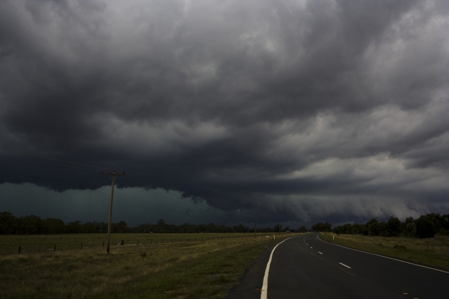
Chase Report 6th March 2010

On Saturday, we opted to chase near Deniliquin given we were never going to chase the Victorian cells anyway. There were cells west of Deniliquin that we took a look at, felt outflow and took off east again. On the way to Deniliquin, a few cells developed along an outflow boundary and forming a squall line. The cell that approached from near Hay looked interesting and made a direct hit on Deniliquin. It had a reasonable structure for a while but became outflow dominant very quickly.


Chase Report 7th March 2010

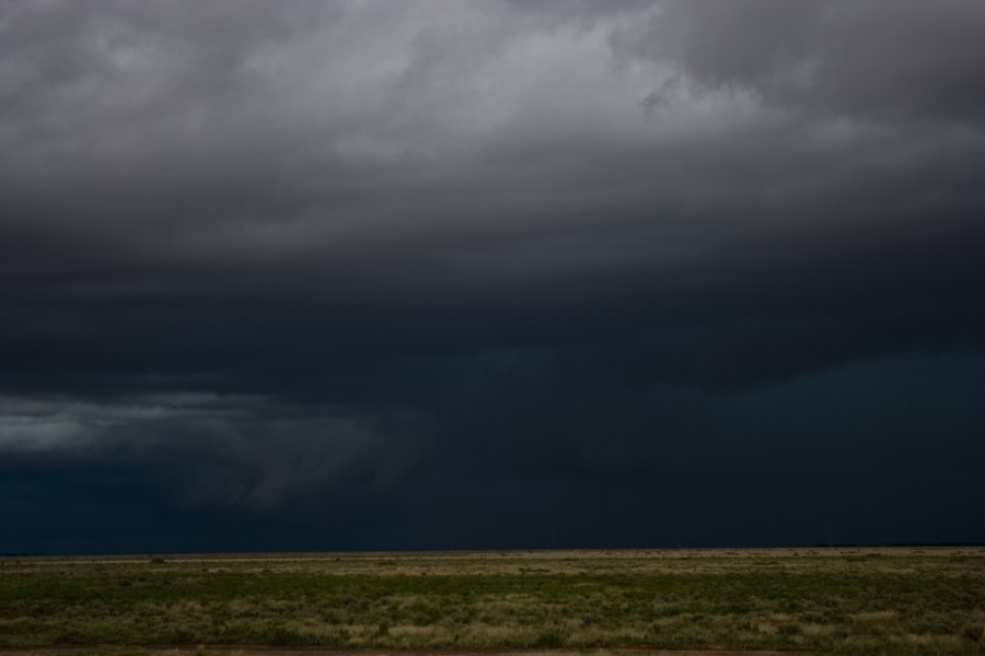
On Sunday, after a night over in Finley, we headed out to the line of storms developing and already severe warned to the west of Deniliquin. The first storm in the lin approaching the Victorian border had an interesting base but difficult to tell from our perspective. We opted to head further north of Deniliquin which was where discrete cells had developed and even this far out of radar produced some strong echos. These slowly began to congeal into a squall line with perhaps embedded supercells. We interceped and timelapsed these cells with some moderate inflow. Above the surface though, winds were rather strong and also from the east. The inflow and outflow interaction was rather sharp and the wind change rapid. This is behaviour atypical of Tornado Alley squall lines.


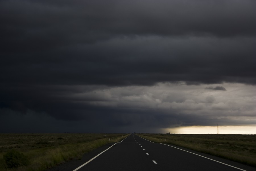
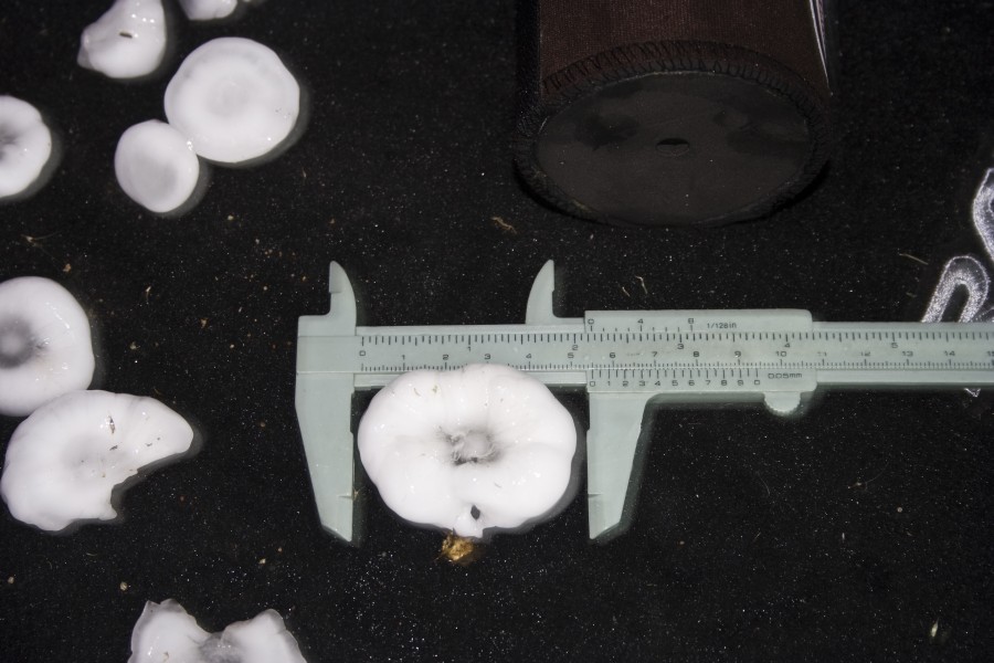
On our treck north, I noted heavy rain and then increased lightning. No sooner than I mentioned we were approaching a core did I hear thumps! From say 2cm hailstones it quickly became 4 to 5cm in diameter. We did stop and the winds had eased with large splashes in the water in the fields. Imelda, Kimberly and Nick all copnfirmed that hailstones larger than the ones we measured had fallen as by the time we got back to measuring these, it was at least 5 minutes or slightly longer. Hailstones were in melt down due to the rain still falling. This was a nice surprise though.

Further east, we attempted to intercept two splitting cells southeast of Griffith though with dwindling fuel supplies and a rapidly developing rain band, these became embedded in the mess. I am glad Nick was able to photograph the right mover which has some interesting structure - though nothing confirmed from our perspective.


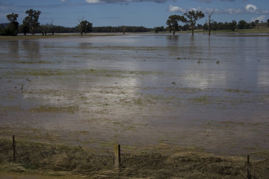
Today, I took a few pictures of the region near Wagga Wagga in flood.


Regards,

Jimmy Deguara
« Last Edit: 10 March 2010, 01:35:27 AM by Jimmy Deguara »
-------------------------------------
Australian Severe Weather
www.australiasevereweather.com

Australian Thunderbolt Tours
www.thunderbolttours.com

Phone  0408 020468  (International :  61  2  408 020468)

Offline Jimmy Deguara

  • Australian and Tornado Alley storm chaser
  • Administrator
  • Wedge tornado F5
  • *
  • Posts: 2,218
  • Gender: Male
  • Storm Chaser since 1993, Tornado Alley 2001
    • Australia Severe Weather
John,

That hailstone size surely must be a record of some sort for the region around Melbourne? What do you mean exactly in the statement the hailstones were not as hard as the ones I recorded? Is there a possibility that hailstones were fused together? Thus far, there is little indication in terms of pictures of hailstones larger than about 8cm so it would be great to have images to show the structure of this hailstone measured. Thanks John for following it up. In my opinion, the atmosphere did not really support such hailstone sizes though if the storm suddenly collapsed - then it may have been a hail dump! This happened a few years ago in the Dorrigo area where 10cm hailstones were dumped suddenly prior to the storm disappearing rapidly from radar. I have seen a similar documented example in the US by Tim Marshall who filmed the hail falling profusely in a hail dump and the radar showing the storm suddenly die! Michael Bath also filmed a hailstorm which broke his windscreen which was in the process of a storm collision (sudden intensification and then gone).

As to the holes punctured by hailstones to 12cm, this is not an indicator of size necessarily but it will be interesting if other hailstones can be found that match or exceed the 10cm diameter. I would rather also get a more thorough reading to the nearest millimetre as 10.0 cm seems rounded off.

Whilst on the subject, here is an article from 1954 Melbourne hailstorm - this storm definitely surpasses it!

http://www.bom.gov.au/amm/docs/1954/forster.pdf

Regards,

Jimmy Deguara
-------------------------------------
Australian Severe Weather
www.australiasevereweather.com

Australian Thunderbolt Tours
www.thunderbolttours.com

Phone  0408 020468  (International :  61  2  408 020468)

Offline ross

  • Rope Tornado F0
  • *
  • Posts: 2
  • Gender: Male
Hi all,

I have been photographing storms for about 25 years. I was in Shepparton to attend a wedding and was staying at the caravan park South of the City center on the Goulburn Vally Highway Kialla. On Sunday the 7th of March as another storm rolled in, I thought I would try my luck for some lightning photos from the new Kialla Coles complex. What hit literately seemed to come from nowhere. Looking back at my images with time tags its two minutes from calm to scary time stuff. I just stepped under the veranda of the shopping centre to get out of the rain that was falling, this was useful for ten seconds, then I stood in front of a pillar that was about as wide as a door for the next 4 minutes. During this time as the wind speed grew and grew I found that I had trouble breathing and curled up on the ground. I was thinking what the hell have I done, I thought my camera and I had bitten off more than we could chew. I must say I'm not sure if the the right word would be scared.

Here is a link to my past images.

http://www.flickr.com/photos/rossfelix/sets/72157604088903601/


I will post more of the Shepparton stuff over the weekend.

I have included an image of my safety spot!
« Last Edit: 12 March 2010, 12:47:13 AM by ross »

Offline Jimmy Deguara

  • Australian and Tornado Alley storm chaser
  • Administrator
  • Wedge tornado F5
  • *
  • Posts: 2,218
  • Gender: Male
  • Storm Chaser since 1993, Tornado Alley 2001
    • Australia Severe Weather
Hi John,

Quote
Should have mentioned, according to David Jones and the Bureau database it is a Melbourne record for hailstones, and not far off the 11cm Victorian record (need to look up where this happened).

I am more interested in what Blair Trewin's final outcome is of this because if it is some sort of record, the measurement device and technique and hopefully some sort of image would have to be taken into account in the quality control process.

Regards,

Jimmy Deguara
-------------------------------------
Australian Severe Weather
www.australiasevereweather.com

Australian Thunderbolt Tours
www.thunderbolttours.com

Phone  0408 020468  (International :  61  2  408 020468)

Offline Jimmy Deguara

  • Australian and Tornado Alley storm chaser
  • Administrator
  • Wedge tornado F5
  • *
  • Posts: 2,218
  • Gender: Male
  • Storm Chaser since 1993, Tornado Alley 2001
    • Australia Severe Weather
Hi John,

I have chased quite a few storms over the years in the giant hail category and the probability is low that the hailstones were 11.0cm and now 10.0cm in diameter given we are now talking about records - not such a good system. Same for the 14cm hailstorm from Kempsey.

The largest hailstone I have measured was 9.6cm with calipers. Records in the United States are also documented thoroughly. Sorry for the slightly off topic reports but this is what I am trying to indicate. And yes you are so correct John, no photographs. Apparently the Kempsey hailstorm way back in December 1991 has a photograph in the local paper which I have not been able to track down though I am not so sure if it was the giant hailstone or a sample of monsters that fell.

Anyway, I will await further details as per usual.

Regards,

Jimmy Deguara
-------------------------------------
Australian Severe Weather
www.australiasevereweather.com

Australian Thunderbolt Tours
www.thunderbolttours.com

Phone  0408 020468  (International :  61  2  408 020468)

Offline Jimmy Deguara

  • Australian and Tornado Alley storm chaser
  • Administrator
  • Wedge tornado F5
  • *
  • Posts: 2,218
  • Gender: Male
  • Storm Chaser since 1993, Tornado Alley 2001
    • Australia Severe Weather
Hi guys,


This picture was taken by a person from Ferny Creek.

Nick named Hillybilly and he quotes:

"BTW here is one damage photo I took of one hail stone hole "  

This is rather close to 10cm.

Now the report was from Ferntree Gully not Ferny Creek. They are a few kilometres apart.

Regards,

Jimmy Deguara
« Last Edit: 12 March 2010, 01:55:36 PM by Jimmy Deguara »
-------------------------------------
Australian Severe Weather
www.australiasevereweather.com

Australian Thunderbolt Tours
www.thunderbolttours.com

Phone  0408 020468  (International :  61  2  408 020468)

Offline Jimmy Deguara

  • Australian and Tornado Alley storm chaser
  • Administrator
  • Wedge tornado F5
  • *
  • Posts: 2,218
  • Gender: Male
  • Storm Chaser since 1993, Tornado Alley 2001
    • Australia Severe Weather
Hi John,

Quote
Have found out some more intriguing info about the large hailstone:
From DJ at the NMOC the 10cm stone at FTG was two 5cm stones which had frozen together (an aggregate). This is starting to sound a little fishy to me.

Thanks for clarifying what was becoming almost obvious to me. Not as hard oas the stones I got sounded unusual given there were no images.
 I don't blame them though - if you are not used to such an event, fusing of hailstones can be easily overlooked though we should question the validity.

The hailstones below are the typical giant hailstone structures with the largest hailstones suffering from considerable melting but we have to take it as is.

Regards,

Jimmy Deguara
-------------------------------------
Australian Severe Weather
www.australiasevereweather.com

Australian Thunderbolt Tours
www.thunderbolttours.com

Phone  0408 020468  (International :  61  2  408 020468)

Offline enak_12

  • Elephant Trunk F2
  • *
  • Posts: 153
  • Gender: Male
I opened the photo in photoshop and using 2 vertical guides to line up the edges of the longest side of the center hailstone along the ruler in the photo and counting down to the nearest millimeter I got exactly 9cm. I think with a bit of melting it could have approached the 10cm mark?