Author Topic: NSW/VIC Severe Storms: 30-31 Jan 2008  (Read 41122 times)

0 Members and 1 Guest are viewing this topic.

Offline Richary

  • Barrel tornado F4
  • *
  • Posts: 680
  • Gender: Male
Re: NSW/VIC Severe Storms: 30-31 Jan 2008
« Reply #15 on: 01 February 2008, 12:35:55 PM »
From here at Rydalmere the storm near Bankstown Airport is building quite nicely, with lots of lightning. Not a real good view from here so far with a low hill immediately to my south (Victoria Road), but I think it will come over quite strong soon. Lots of rumbles from the south now and still strong SE winds. Might finally cool it down a bit at night!

Offline David C

  • Global Moderator
  • Barrel tornado F4
  • *
  • Posts: 643
  • Gender: Male
    • Thunderbolt Tours Storm Chasing Adventures
Re: NSW/VIC Severe Storms: 30-31 Jan 2008
« Reply #16 on: 01 February 2008, 12:41:07 PM »
Storm currently going through Padstow at the moment. Very lightning active and good steady rain here. We did not got any winds of note although a 95km/h gust was recorded some 10km west of here. It was nice to see those cells fire up along a gustfront put out by the storms over the outer southern suburbs.

Must say that is an interesting base reflectivity scan just come through (7:30UTC). Let's see the subsequent scan
Storm Chaser,
Thunderbolt Tours - USA & Australia Storm Chase Tours
www.thunderbolttours.com

Offline Richary

  • Barrel tornado F4
  • *
  • Posts: 680
  • Gender: Male
Re: NSW/VIC Severe Storms: 30-31 Jan 2008
« Reply #17 on: 01 February 2008, 12:54:55 PM »
6:54pm Just starting to get hail here between pea and marble size, and the lightning is getting nice and close!

7:15pm The main band has passed over, giving us 8mm in 20 minutes. Looking at the radar the heaviest part was east of here, for example Olympic Park has had 16mm so far. Some nice lightning which I tried videoing until it got too windy and was blowing the rain towards the camera.

Seems to be exhibiting strong outflow, with the rain/wind coming initially from the SE and now from the NE as the storm moves towards Gordon. Unfortunately that meant whatever side of the house the storm was on, the rain was blowing in from that way as well making taking shots harder.
« Last Edit: 01 February 2008, 01:15:54 PM by Richary »

Offline scottme

  • Multi-vortex F1
  • *
  • Posts: 37
  • Gender: Male
Re: NSW/VIC Severe Storms: 30-31 Jan 2008
« Reply #18 on: 01 February 2008, 01:23:36 PM »
Wow, looks like that outflow has become inflow on a storm that sprung up over just west of Paramatta.

Offline Richary

  • Barrel tornado F4
  • *
  • Posts: 680
  • Gender: Male
Re: NSW/VIC Severe Storms: 30-31 Jan 2008
« Reply #19 on: 01 February 2008, 01:33:36 PM »
I noticed that new one spring up out of nowhere. Unluckily it has tracked too far NW to get a good view. One of the Bankstown area small ones looks like it might be getting a left hand movement and heading this way.

jennifer barnard

  • Guest
Re: NSW/VIC Severe Storms: 30-31 Jan 2008
« Reply #20 on: 01 February 2008, 02:58:27 PM »
Hi All,
Yes my first post after spending a fair amount of time reading the posts and looking at the photos. Great photos lately Mike! but also compliments to everyone else too!

I'm writing this post about the storm that passed over us here at Quakers Hill probably about an hour ago now. My husband and our neighbour have been here for many years and they say this was the worst they have seen in terms of the amount of rain that fell! We had water coming in three window areas, through the garage and our new carpet is wet in the main bedroom - all of the windows were closed (of course). We had I suppose you would say moderate hail  but only small in size but enough to clog the gutters. We can see to the west from our front door and we could barely see across the road. The runoff was too much for the storm water drains and the road became flooded (and we live on the high side of Quakers Hill). I'm sure low lying areas were hit hard.

More lightning and thunder as I write.

Hope all chasers are safe and there has been minimal damage

Cheers

Jen

Offline Michael Thompson

  • Multi-vortex F1
  • *
  • Posts: 57
Re: NSW/VIC Severe Storms: 30-31 Jan 2008
« Reply #21 on: 01 February 2008, 03:52:58 PM »
31st January 2008 - Storm chase , Wollongong to Holsworthy

  All photos clickable
 

Quite a productive after work storm chase this afternoon, but a case of I wished I had the video camera.

I initially headed south from Wollongong, but quickly backtracked as the Shellharbour stuff become rather outflow dominated.

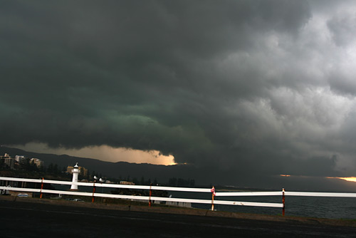
Watched from Wollongong harbour as new development occurred just over the escarpment.

You can tell the fresh development by the green.


I headed north along the coast road. Around Bellambi the sky just cut loose with torrential rain and hail, but it was the lightning that was the main feature, close CG's one after the other.A full on barrage.

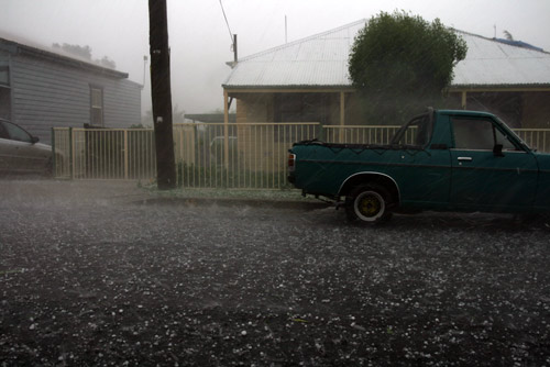
Here is some of the hail near Woonona, 2cn., perhaps the odd 3cm stone. There was major flash flooding and small tree branches down.


I headed north determined to get ahead of the outflowed fueled northward propagating cell.

Views are poor in Sydney's far south. Here is the Wollongong cell weakening


As I was watching this I had storm chaser convergance with James, we speculated on the rather   semi interesting development to the west. We noted a few CG's apparently well ahead of thr rain core, so I decided that the Heathcothe Road was worth a trip.

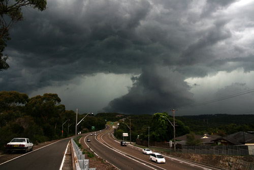
Along the Heathcothe road and it became apparent that a better cell was organising SW of Liverpool.

It had some interesting structure !


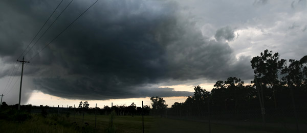
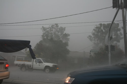
I knew that with higher surface temperatures over Liverpool compared to the coast that microburst activity may be a feature.

The photos do not do justice to the winds, and a second grand CG barrage for the day.


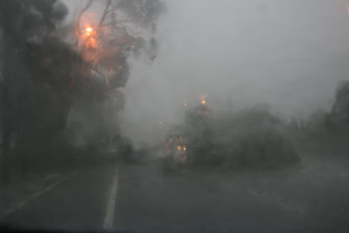
Near Moorebank ( I think ) my chase ended with a tree over the road. I was the second car blocked by the tree, it fell whilst I was at traffic lights 30m back up the road.


All in all a fantastic trip, but video would have been a killer.
« Last Edit: 02 February 2008, 01:25:20 AM by Jimmy Deguara »

Offline James

  • Elephant Trunk F2
  • *
  • Posts: 149
  • Gender: Male
    • Sydney Storm Chasers
Re: NSW/VIC Severe Storms: 30-31 Jan 2008
« Reply #22 on: 01 February 2008, 05:03:00 PM »
Had a brief successful chase this afternoon starting at Campbelltown and nearly doing a loop down to Picton/Appin/Bulli/Waterfall/Holsworthy and then back up to Galston.

Watched the earlier cells near wollongong go nuts from near Campbelltown. The NW flanking line started to get its act together with some crisp powerful updrafts however the bases were still quite high at this point. I opted for the coastal show at the start knowing the lightning and features were much better.


Those cells had some very intense, frequent lightning for quite a while until it started to gust out and the focus turned to the new cells developing on the earlier storms outflow.

Chaser convergence with Michael T was a nice surprise and as Michael said, we both agreed that the cells to the west were starting to become nice and organised. After dodging a few close flangs I headed up Heathcote rd to Holsworthy where a strong rippled base had developed and was ready to let loose a barrage of cg's, rain, hail and wind.


The wind was intense in bursts with branches coming down around my location. Hail was small however the lightning was frequent and constantly pounding all around. Heavy rain gave some flash flooding and it wasn't long before I was stopped by a tree across the road (I have a feeling its the same tree as your photo MT - I would have been around 6 cars back. I managed to get around it by driving onto the footpath behind a 4wd). After getting past this blockage I managed a awesome view of the back end structure a I headed north on the M7 back home.


Before turning onto Galston Rd I stopped at the Dural lookout and watched the beginning of the big cell over NW Sydney around 7pm


Offline Michael Thompson

  • Multi-vortex F1
  • *
  • Posts: 57
Re: NSW/VIC Severe Storms: 30-31 Jan 2008
« Reply #23 on: 01 February 2008, 05:29:31 PM »
Yes James that would have been the same tree as I too had to do the drive down the the bike track. Glad you went the Heathcothe Road option.
« Last Edit: 02 February 2008, 01:25:55 AM by Jimmy Deguara »

Offline Richary

  • Barrel tornado F4
  • *
  • Posts: 680
  • Gender: Male
Re: NSW/VIC Severe Storms: 30-31 Jan 2008
« Reply #24 on: 01 February 2008, 06:05:38 PM »
Didn't go chasing here, but yes it was interesting how it developed. Ignoring the earlier stoms that caused a few accidents around Wollongong, the main one that tracked east of Parramatta (and I got the edge of at Rydalmere) had significant outflow that seemed to spark another storm west of Parramatta. That one went on to the north and from the radar images got quite intense up towards Glenorie (Black centre on the image).

Interesting how the 2nd Parramatta storm developed very quickly, and seemed to at the same time suck the life out of the first one which petered out just NE of Gordon.

The 2nd line of storms up here were mostly intra-cloud lightning, compared to the first one which had lots of multiple CGs and crawlers. Had a bit more briefly heavy rain though, the one that came through here had developed and split off the line near Bankstown before hanging a left and coming over this way.

Offline Jimmy Deguara

  • Australian and Tornado Alley storm chaser
  • Administrator
  • Wedge tornado F5
  • *
  • Posts: 2,218
  • Gender: Male
  • Storm Chaser since 1993, Tornado Alley 2001
    • Australia Severe Weather
Re: NSW/VIC Severe Storms: 30-31 Jan 2008
« Reply #25 on: 02 February 2008, 01:38:40 AM »
Hi all and Jennifer,

Report of the severe storm event 31st January 2008

Living at Schofields, it is great to note the slight difference between the duration and intensity of the storms.

Schofields was hammered by the same storm hitting Quakers Hill - apparently Rune who also lives at Quakers Hill reported 48mm in 30 minutes - very intense rainfall rates. We had a total of 47.8mm including a little more rainfall later in the night.

The difference is we had power failure that took all night to rectify. The cloud to ground lightning was quite intense but the winds were very powerful tossing a lot of the items around. We also had hail dumping for about 5 minutes. I was able to capture the microburst and hail. The winds swung around and I had to close an upstairs window and when I returned the winds had sprayed both my cameras with the digital still on the ground! So the winds had begun from the south and then veered from the west.

Anyway, that was one intense storm. It seemed to develop just to our south and southwest. despite an outflow area and associated shelf cloud moving through earlier, the development of this cell was behind that outflow and and elevated above the boundary layer. The winds at the base seem to come from the north feeding into the developing storm. As soon as precipitation began to develop to our south probably Quakers Hill area, the lightning barrage began and intensified. The rain became more intense and at one stage I could hear the roar of heavy rain about half a kilometre away. But it still took sometime to for this to finally arrive. Slow moving means flash flooding.

Anyway, a good way to end January. Photoraphs to follow below.

Regards,

Jimmy Deguara
« Last Edit: 02 February 2008, 12:48:02 PM by Jimmy Deguara »
-------------------------------------
Australian Severe Weather
www.australiasevereweather.com

Australian Thunderbolt Tours
www.thunderbolttours.com

Phone  0408 020468  (International :  61  2  408 020468)

Offline David C

  • Global Moderator
  • Barrel tornado F4
  • *
  • Posts: 643
  • Gender: Male
    • Thunderbolt Tours Storm Chasing Adventures
Re: NSW/VIC Severe Storms: 30-31 Jan 2008
« Reply #26 on: 02 February 2008, 04:25:17 AM »
Anyway, that was one intense storm. It seemed to develop just to our south and southwest. despite an outflow area and associated shelf cloud moving through earlier, the development of this cell was behind that outflow and and elevated above the boundary layer.
Regards,

Jimmy Deguara


Hi Jimmy the 1st 'main' storm that moved across the metro area appeared to develop along an old gustfront, put out by the storm(s) further south over Wollondily etc -- the outflow itself was marked by a shelf cloud that became detached and moved out way ahead of the rain core of the weakening storm and soon developed into rapidly growing cumulus. There was some really nice dynamic cloud-base motion and powerful bolts as the northeast winds and the outflow converged over the southwest suburbs (as per Michael's and James' images above of Holsworthy area).
Storm Chaser,
Thunderbolt Tours - USA & Australia Storm Chase Tours
www.thunderbolttours.com

Offline Shaun Galman

  • Stove pipe F3
  • *
  • Posts: 441
  • Gender: Male
    • ridgelightning.com
Re: NSW/VIC Severe Storms: 30-31 Jan 2008
« Reply #27 on: 02 February 2008, 10:44:33 AM »
Hi all,
Great chase/report on the Sydney storm/s guys!

31st Jan. 2008 Upper Western/North West Area, Storm Report & Photos

We had quite a mixed day here yesterday, kicking off with a storm forming over Cumborah (30-odd k's SW of Lightning Ridge) that I noticed on radar along with plenty of lightning activity. I went out for a look and straight away noticed the large anvil that was showing on the sat. pics. The panorama below is looking SW from town at the storm, I took this from our airport at 4:25pm.


Across the afternoon we got buried in a large anvil shield forming from numerous towering updrafts that would soon collapse into nice little cells, some showing nice CG activity here and there. The cell below had the nicest structure of the arvo. Taken 15k's North of town around 5pm this cell also had the odd CG branching from the rear base (right side of the photo). It seemed like there were up to 10 or 12 small rain cores around us at any one point, most threw down the odd CG or two.


After returning home from getting a few shots of the surrounding cells, I did notice a rather large and ominous looking rain core forming to our South at 6pm, while watching it for only a few seconds, close CG started firing down so I raced to the southern edge of town for a better view! I was only there momentarily when the dreaded rain started sprinkling (as you can see from the rain spots on photo) creating EXTREMELY dangerous conditions for photography as there were CG firing down 360ยบ around me, time to bid a hasty retreat to the ute! The photo below (taken at 6pm) was the only CG I managed for the arvo as it was just too dangerous guys. No real structure to be seen just a grey looking HP rain shaft with a ridiculous amount of atmospheric charge!


Rain totals were only 5mm in town from a shower last night. The sparseness of the cells didn't help totals either but I would imagine falls would have registered in the 10-20mm per hour range in some of them.
Cheers and take care.
Shauno.

A few storms about the place today once again so I'll see what eventuates tonight. I'd love one of these highly active storms to approach town during darkness, as they used to many eons ago! lol ;)
Chasing Region: Lightning Ridge. N.S.W.
Website: www.ridgelightning.com

Offline Jimmy Deguara

  • Australian and Tornado Alley storm chaser
  • Administrator
  • Wedge tornado F5
  • *
  • Posts: 2,218
  • Gender: Male
  • Storm Chaser since 1993, Tornado Alley 2001
    • Australia Severe Weather
Re: NSW/VIC Severe Storms: 30-31 Jan 2008
« Reply #28 on: 02 February 2008, 12:45:18 PM »
Photographs 31st January 2008 Severe Thunderstorm event

All from home given I did not bother chasing

This is the northern edge of the storm developing over the southwestern suburbs


Associated upfraft exposed


Dust rising from a building site below the developing base


The Schofields/Quakers Hill cell developing base


On of the many daytime lightning bolts


Hailstones falling in the core of the thunderstorm - the winds were still battering in gusts


Full set of pictures available here:
http://australiasevereweather.com/photography/photos/2008/jd20080131.html

Regards,

Jimmy Deguara
« Last Edit: 03 February 2008, 04:56:57 AM by Michael Bath »
-------------------------------------
Australian Severe Weather
www.australiasevereweather.com

Australian Thunderbolt Tours
www.thunderbolttours.com

Phone  0408 020468  (International :  61  2  408 020468)

Offline Harley Pearman

  • Barrel tornado F4
  • *
  • Posts: 584
Re: NSW/VIC Severe Storms: 30-31 Jan 2008
« Reply #29 on: 02 February 2008, 03:17:27 PM »
Storm report Thursday 31 January 2008

I was watching the Wollongong storm on various radars for a while and recognised the outflow boundary NW of it and the presence of the southerly change. I did some mathematics and calculations on it and figured that I only needed to travel 2 km west of where I work to score a direct hit on a storm cell.

I went to Duck River Parklands near Mona Street Auburn for a prime spot and watched the storm over Wollongong however, I watched and photographed a new storm cell to my SW that intensified rapidly around 6 pm and with it came a barrage of cloud to ground lightning bolts.

It headed in my direction but better still, the North west portion of the storm cell headed in my direction and I knew my mathematics had paid off.

The storm at my location started with intense drizzle blowing sideways in gales blowing from a southerly quarter. Leaves and bark were being stripped from trees from the down bursts for a while. Then came a solid barrage of rain and then hail up to 1.5 CM in size (I managed to estimate the size of some stones that fell near me). As the core passed directly over me, I found myself in some trouble. I was under a small shelter but soon found myself walking in water up to 10 CM deep. The playing fields in front of me quickly became flooded and I effectively experienced some flooding due to the amount and intensity of rain falling.

A solid bolt of lightning hit an object very close to me (I think the Auburn Council sign post nearby to my north). I could smell the burning of an object immediately afterwards and it was a very close strike.

Amazingly, I experienced another significant downburst at the rear of the storm and winds were blowing from a NE direction this time coupled with torrential bursts of rain. The storm was obviously dumping rain at this stage.

The decision to catch the north west portion of the storm proved to be fruitful, given that I witnessed some tree damage, power loss, hail, significant lightning and flooding.

Rosnay Golf Course nearest to me and Mona Street Auburn, 1 km to the south with a weather station recorded 34 mm of rain from that storm indicating that the rainfall at my position would have been in the vicinity of that figure.

I drove through another rainstorm on my way home but the rain was not as heavy as the Auburn event and I did not experience any further hail.

The whole Thursday event produced some solid rainfalls in parts of Sydney such as:-

Auburn (Varied between 39 mm and 47 mm).
Seven Hills 22 mm.
A suburb near Hornsby close to Turramurra recorded 71 mm being the highest figure.

The highest rain falls occurred in a line from Liverpool NE towards Hornsby through Auburn and anyone in this corridor such as myself would have experienced a significant storm event with local flash flooding. Numerous traffic lights, local power failures featured around Auburn and Granville following the storm and up to 17,000 homes were blacked out for a while.

Harley Pearman