Author Topic: NSW storms 14 - 21st November 2007  (Read 52907 times)

0 Members and 1 Guest are viewing this topic.

Offline James

  • Elephant Trunk F2
  • *
  • Posts: 149
  • Gender: Male
    • Sydney Storm Chasers
Re: NSW storms 14 - 21st November 2007
« Reply #30 on: 20 November 2007, 03:38:36 PM »
November 18, Southern Highlands: Photos


Some photos to go with my report earlier. Will try and get a video clip up a little later.

The view from Taralga south to Goulburn early mid afternoon. Nice cumulus but high based.    

View of the early Pulse storms north of Taralga
 

Looking south east towards the developing complex north of Tarago. Note the inflow bands on the left.
 

Further development on the western flank


Looking east towards Lake Bathurst. Main updraft region with cumulus inflow line feeding in from the North.
 

Lightning south of Goulburn
 
« Last Edit: 24 November 2007, 11:45:58 AM by David C »

flipwx

  • Guest
Re: NSW storms 14 - 21st November 2007
« Reply #31 on: 20 November 2007, 05:20:48 PM »
November 18, Southern Tablelands: Chase Report, Photos, Video

Hey all! I went on a chase with with Shane, Steve and Jim and ended up in the Bungendore region in the afternoon then later on tracking north following cells as they developed back up to Goulburn.

Updrafts South of Bungendore/Captains flat area:
This storm exhibited some decent rotation in the updraft region as evident in the timelapse below.

This was over a brief 7min period:
timelapsesouthofbungendore_web.wmv  (4mb)

Youtube version:
 http://www.youtube.com/watch?v=CwuIPpDajNU

Photographs:


This is where the storm nearish to collector exploded with rapid upmotion visible in the wall cloud/lowering region:


The Storm begins to take on a more outflow/gusterish appearance:


Some of the lightning:


« Last Edit: 24 November 2007, 11:46:21 AM by David C »

Offline Jimmy Deguara

  • Australian and Tornado Alley storm chaser
  • Administrator
  • Wedge tornado F5
  • *
  • Posts: 2,218
  • Gender: Male
  • Storm Chaser since 1993, Tornado Alley 2001
    • Australia Severe Weather
Re: NSW storms 14 - 21st November 2007
« Reply #32 on: 20 November 2007, 05:37:21 PM »
Hi,

November 19, Central Tablelands: Chase Report

Great to see people out and about - wow some nice storms around. Awesome! And they are very well structured - a nice surprise packet.

I initially targeted Oberon to Organge region but kept m options for Lithgow. I headed to Mt Victoria to asses the situation and watch development unfold. I noted that cumulus closer to the Oberon Plateau developing - well make that Jenolan Caves area.

This storm organised its base early and then dropped precipitation in the Cox's River valley. So I followed the storm to near Hampton and then towards the region overlooking Hartley. The storm had gained in lightning activity and also structure. A dense precipitation curtain including hail began to hug the Mt Victoria area. By the time I reached Hartley itself, I was virtually under the structure and wall cloud. The base was nice and circular - quite a surprise actually!

I made my way to Lithgow in readiness for this storm to create a barrage. I ended up having to get the storm near Scenic Hill lookout where I skirted just outside the main core but still was content with hail to 2cm or so.

Back in Lithgow, I had a couple of things to do regarding the internet and finally got them done in time for the next storm looming. This storm also skirted Lithgow so I headed up to the region near the Zig Zag railway and intercepted hailstones once again - it seems about 1cm in diameter.

Venturing towards Rhylstone just did not allow access to the storm in time so we headed for Bathurst. Yes there are some storms around as I type including those at sunset. I did not bother with lightning shots or chasing this - was too hungry and settled for a nice steak.

The first storm with interesting structure - looks to be a wall cloud


Second storm followed the first


« Last Edit: 24 November 2007, 11:46:39 AM by David C »
-------------------------------------
Australian Severe Weather
www.australiasevereweather.com

Australian Thunderbolt Tours
www.thunderbolttours.com

Phone  0408 020468  (International :  61  2  408 020468)

Offline Michael Thompson

  • Multi-vortex F1
  • *
  • Posts: 57
Re: NSW storms 14 - 21st November 2007
« Reply #33 on: 20 November 2007, 06:32:21 PM »
November 18, Southern Tablelands: Chase Report and Photos

Goulburn 12pm, my kestral told me something completely different to the models - a dewpoint in single figures. I started to worry. There
was some high based Cu around, but it was struggling.


I was getting more and more sunburnt. I opted for some shade SE under the struggling Cu - myself and Steve Gabriel headed for Windellema, SE of Goulburn.

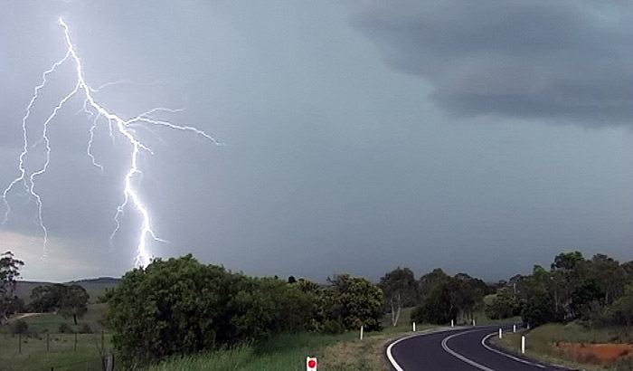
The local cells struggle - meanwhile I take interest in a general darkening to the far south. We head south to the Tarago - Braidwood road.


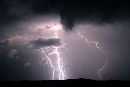
We watch several CG's. Itchy feet get the better of me and as always I wanted to be closer, so I leave Steve and Pingtang behind. I found a nice hilltop and captured these video stills.


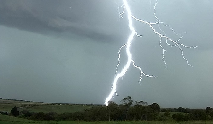
In hindsight it was probably foolhardy as these bolts were coming down less than 1km away and lower than me. It started to rain anyway, so I packed up and headed to the Kings Highway and turned west to Bungendore. Here I struck the first small hail and minor flash flooding for the day. From Bundendore I head north through another small cell and reunite with Steve and Pingtang.


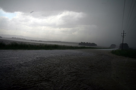
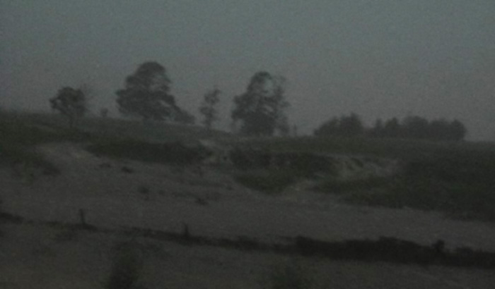
After meeting Steve and Pingtang again I thought the show may be drawing to a close - so I said my farewells and headed north. Just north of Lake Bathurst I encountered another cell with a mix of torrential rain and hail. The picture belows shows some minor flash flooding both on the road and in the fields.
     

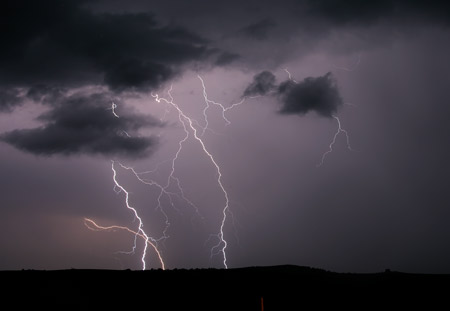
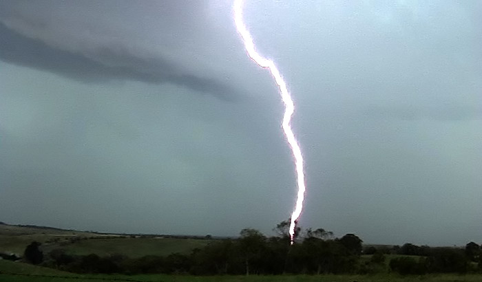
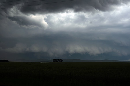
I head just a little further north and as the rain cleared this is what revealed itself to the SW.


Needless to say I scrapped plans for an early return home and turned south to Tarago once again. From Tarago I took the Collector road to get NW which is where the lightning was most active. It was near sunset but I was plunged into night as I core punched the storm. The next 30 mins were very exciting. It was too dark for photos so I can only offer grainy video stills.

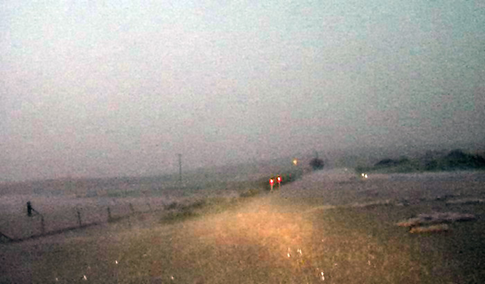
In this still there is water across the road and hail drifts.


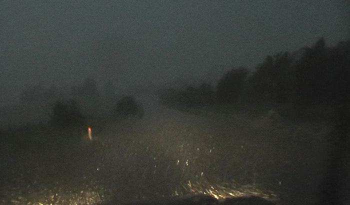
A farmers dam overflows


Look closer at this still, on one side of the road there is a road guide pole, there is also one one the other but a surge of water is over running it - this river continues down the road for at least 500m. I am thankful of my large 4WD


Lightning during the core punch was every few seconds, but the hail/rain mix drowned all thunder.
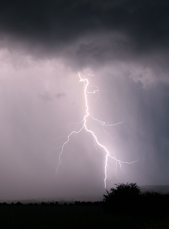
I finally broke free of the rain and pulled over an took some lightning pics. James Harris and crew converge on the scene as well, they also encountered this storm from the inside.


« Last Edit: 24 November 2007, 11:50:06 AM by David C »

Jeff Brislane

  • Guest
Re: NSW storms 14 - 21st November 2007
« Reply #34 on: 21 November 2007, 05:10:04 AM »
Wow, some very interesting storm structure from various people in this thread! I'm liking the look of todays situation even though the winds aloft are pretty dull, there is plenty of dry air aloft and reasonable instability which should produce some hail again. The area south of Cooma is looking very interesting as the cap is strong, the instability is moderately strong and there is a hint of turning in the winds aloft so maybe a late severe storm for the southern coast and even into Victoria. As for west of Sydney i'm going to head out to see if there is going to be some hail about again which there should be.

Tomorrow though is another thing all together! Strong instability with high CAPE values should see some explosive CB's of gargantuan proportions!

Jeff.
« Last Edit: 24 November 2007, 11:47:26 AM by David C »

Offline Ben

  • Multi-vortex F1
  • *
  • Posts: 34
  • Gender: Male
Re: NSW storms 14 - 21st November 2007
« Reply #35 on: 21 November 2007, 05:31:30 AM »
Awesome storms captured by everyone!!! Thanks Jimmy for getting that storm that went through Blackheath-Lithgow!! I missed it and was curious to see what was under it, you captured it pretty well!!!
« Last Edit: 24 November 2007, 11:47:40 AM by David C »

Offline Harley Pearman

  • Barrel tornado F4
  • *
  • Posts: 584
Re: NSW storms 14 - 21st November 2007
« Reply #36 on: 21 November 2007, 03:08:54 PM »
November 18, Southern Tablelands: Chase Report

Michael Thompson's photographs of lightning is awesome. The last one is incredible and very spectacular. I was in this region on the afternoon of Sunday between 12 noon and 4 pm. I left at 4 pm because all I was getting was the development of pulse type showers and small storm cells for a few hours and at the time of leaving, I did not see any further significant storm or cloud development and the storm I was photographing and the storm to the north were both weakening.

What a difference a couple of hours make.

I noted later on (Some 3 hours later) that the Bureau of Meteorology had issued a severe thunderstorm warning on the storm just to the south of Goulburn for heavy rain, large hail and strong winds. I had a look at the rainfall figures later on and a place near Lake Bathurst scored 66 mm of rain while 12 mm fell at Goulburn. Most other falls in that region were light. It indicates that the evening storm was highly localised (consistent with what I was watching earlier in the day).


Harley Pearman

« Last Edit: 24 November 2007, 11:47:56 AM by David C »

Offline dann weatherhead

  • Multi-vortex F1
  • *
  • Posts: 32
  • Gender: Female
    • Sydney Storm Chasers
Re: NSW storms 14 - 21st November 2007
« Reply #37 on: 21 November 2007, 04:35:57 PM »
November 18, Southern Tablelands: Photos

A selection of my pics! More can be found starting   here.


« Last Edit: 24 November 2007, 11:48:14 AM by David C »

Offline Ben

  • Multi-vortex F1
  • *
  • Posts: 34
  • Gender: Male
Re: NSW storms 14 - 21st November 2007
« Reply #38 on: 21 November 2007, 08:42:45 PM »
November 19, Central Tablelands: Photos

I was on that Marulan storm too Jimmy - but on the north side of it! It too was my target. I saw some pretty intense flooding from it.. it was quite a severe storm. No wonder I could not see many CG's but hear heaps of thunder, probably all on the S side cos I didnt realise it was moving S!! I saw that hail fog to the left, drove down into the valley and wondered where all the hail was?? Obviously you found it well done!! Fantastic storms by everyone. Anyway heres some lightning pics from Bathurst on the 19th


Will get my Goulburn/Marulan ones up in the next couple of days

Edited this statement Fantastic photos by everyone else. --> Although we know everyone means well, the focus on this forum are the storms and their descriptions - it certainly makes you think more about what you write and there is more substance to each post.
« Last Edit: 24 November 2007, 11:48:34 AM by David C »

Offline James

  • Elephant Trunk F2
  • *
  • Posts: 149
  • Gender: Male
    • Sydney Storm Chasers
Re: NSW storms 14 - 21st November 2007
« Reply #39 on: 22 November 2007, 02:46:23 AM »
November 18, Southern Tablelands: Video

Finally got some video up from the Collector-Tarago storm on Sunday. Head to   SSC Video Log to watch the videos. Will add a few more shortly

James
« Last Edit: 24 November 2007, 11:48:52 AM by David C »

Jeff Brislane

  • Guest
Re: NSW storms 14 - 21st November 2007
« Reply #40 on: 22 November 2007, 03:55:38 AM »
Hey everyone,

I know you all got some nice storms with nice photos but this system is still going and it's peaking today so can we have more conversation about yesterdays (November 20) event as well as todays (November 21) obvious severe storm threat? Maybe reports and photos should be seperated onto a post thread like stormtrack.

True to my forcast yesterday (November 20) a very large thunderstorm broke the stronger cap on the NSW/Vic border around 6pm and remained almost stationary (probably back building?) for nearly 3 hours! It had by far the largest anvil shield of any storm yesterday and would have been an awesome sight if someone was chasing down there. It looked like it was proabaly helped along by outflow boundarys from earlier storms nearby.

Anyway yesterday I ventured out to Mt Vic but it was a complete waste of time. Storms were weak and nothing like the forcast suggested. One notable exception to the weakness was a brief severe looking cell that developed west of Barrington Tops. It had a noticable overshoot from Faulconbrige on my way home around 330pm.

November 21:
Today is looking very interesting except for weak mid to anvil level winds. Still worth a chase though with cape values around 2500 and li approaching -8! lowerlevel winds aren't bad so i'm guessing the earlier development will be the best.

Jeff.
« Last Edit: 24 November 2007, 11:50:28 AM by David C »

striker92

  • Guest
Re: NSW storms 14 - 21st November 2007
« Reply #41 on: 22 November 2007, 01:30:47 PM »
November 21: Observations, Illawarra

Unbelievably electric storm here south of shellharbour!
Hailing up to 1 cm and some nice structure but guess what! Cannon have my camera.  >:(
Whats the forecast for tomorrow and Friday?
cheers
Mark
« Last Edit: 24 November 2007, 11:50:49 AM by David C »

Offline James

  • Elephant Trunk F2
  • *
  • Posts: 149
  • Gender: Male
    • Sydney Storm Chasers
Re: NSW storms 14 - 21st November 2007
« Reply #42 on: 22 November 2007, 05:05:35 PM »
November 21, Central Tablelands: Chase Report and Photos

Headed into the mountains mid afternoon and managed to get a storm on the way up, one at Lithgow and another on my return home in Galston. If only that happened every other chase day.

Updrafts over the Blue Mountains as the early cells over Oberon propagate north towards Katoomba. 


Developing bases near Mt Lambie


Interesting feature with the steam from the power station west of Lithgow producing extra moisture for one particular base. This continued for over 30 minutes with a continual base lowering down towards the power station exhaust.
 

Lightning striking the valley below Kurrajong Heights
 

Lightning around Galston later in the evening


« Last Edit: 24 November 2007, 11:51:08 AM by David C »

Offline Jimmy Deguara

  • Australian and Tornado Alley storm chaser
  • Administrator
  • Wedge tornado F5
  • *
  • Posts: 2,218
  • Gender: Male
  • Storm Chaser since 1993, Tornado Alley 2001
    • Australia Severe Weather
Re: NSW storms 14 - 21st November 2007
« Reply #43 on: 23 November 2007, 02:28:11 AM »
Hi all,

Central Tablelands chase - 21st November 2007

James, we must have been so close on that Lithgow storm!

Yesterday was one of those rushed chases and I felt it was ideal to have left earlier. As Jeff suggested, the storms did explode. With upper level dynamics very weak, it was important to be there quickly. I virtually left here, passed the cell north of Mt Tomah and arrived on the scene in Katoomba in the hail core. Very little time or opportunities to take spectacular photographs. Yes there were hailstones in the vicinity of 2cm or slightly larger definitely less than 3cm. Some very tall uprafts on this storm! I assume cloud tops were pretty high. The hail was worst around the Katoomba area but still persisted near Leura and perhaps beyond but by then the storm was entering the Gross River Valley. Eventually I turned around and the storm was definitely off to the east.

So I decided to be patient and wait near Mt Victoria and the cells seemed to indicate backbuilding behaviour which was not surprising given lack of upper level support. It was a waiting game so I eventually ventured in the Hartley valley area in anticipation of development in that area.

After about 30 minutes, the development of cumulus in coverage and intensity became rapid. Repositioning in the region around Lithgow basically put me into a few hailstones once again after a barrage of lightning. The barrage of lightning continued as the main cell to the south Lithgow dumped onto Lithgow. In fact, one bolt hit in South Lithgow and created sparks - it was only 5 metres away! There were a few other very close bolts with canon style thunder!

The storm dumped hail up to pea sized in and around town and copious amounts of precipitation. There was nothing unusual about the run-off given the intensity of the rainfall. After some time, I could see the whole region was wiped out besides lingering lightning so I simply headed back to Sydney. A few close cannon style bolts yet again. Our dog "Sally" was definitely frightened!

I did not bother with lightning pictures but it is great to see James and others did very well. Nice lightning bolts too!

Katoomba cell


Lithgow cells


Just for interests sake, I have now observed hail on 5 out of the past six days - three days having two storms with hail on the day intercepted. This for me is unprecedented.

Regards,

Jimmy Deguara
« Last Edit: 24 November 2007, 11:51:23 AM by David C »
-------------------------------------
Australian Severe Weather
www.australiasevereweather.com

Australian Thunderbolt Tours
www.thunderbolttours.com

Phone  0408 020468  (International :  61  2  408 020468)

Offline Shaun Galman

  • Stove pipe F3
  • *
  • Posts: 441
  • Gender: Male
    • ridgelightning.com
Re: NSW storms 14 - 21st November 2007
« Reply #44 on: 23 November 2007, 05:59:50 AM »
Hi guys,

November 21: Upper Western Area Chase Report and Photos

Had a relatively small cell form 15klms to the SW of Lightning Ridge yesterday at 5pm. The temps were up at 38.6deg. and relatively high humidity so we were definitely ready for a storm! Russ and I were waiting to see if anything would come of this cell as it seemed to be buried under the anvils of two weak but quite large storm systems that split around us on the North and South sides. It was all high based with no real structure to be seen (unlike the amazing storms I have seen on the forum in the last few days!) but would quickly turn into an electrical monster! I headed back home to grab my camera and try for a few day shots of the fierce CG emitting from the confined rain shaft.

This 90deg Panoramic shot was taken not long after the cell formed, by this time the CG were at the usual 10-15sec intervals. I did notice that the wheat stubble was burning out on the (dry) lake to the west of town (right side of the shot), so with the build-up of smoke particles and heavy humidity, this was causing CG to fire through it as much as 15k's away from the rain core (left side of the shot). I knew this would be a problem.

The dry CG were approaching fast and seconds after the above shots were taken, I thought "I may be in danger here and should head for the ute asap!" then I saw a bright white flash and a resulting loud CRACK, only to turn around quickly and see the end of a staccato bolt hitting 20mtrs behind me! The surrounding ground was sandstone so I was very fortunate that it is non conductive, unlike the ironstone here! I legged it to the ute and got out of there! It's the closest I've been to a strike in a couple years now and I may head out today and see if I can locate the tree or object it hit, possibly try to dig for a fulgorite if it is possible?

I headed to the Northern end of town where the cell was growing in size dramatically and I would encounter an amazing display of CG that by this time were firing around 6sec intervals with the usual accompanying cracks of thunder. If this storm had of formed at night, the lightning shots would have been spectacular!


I switched to video mode to capture the CG as it was everywhere and I was having no luck with photos being confined to the car interior (it was the first time in 5yrs I've ever felt the need to sit inside the ute!) I got "core punched" at this point with heavy rain that seemed to be horizontal. No hail to report but the rain totals must have been up there?


I met up with Russ back in the main street around 6:30pm with the storm still highly active but heading East quickly. I grabbed a few shots of distant bolts and some base structure that formed ahead of an oncoming steady rain storm approaching from the West.


Not too bad an outcome (other than almost being struck?) for a weak looking "grey" confined core with no real structure lol?
Cheers guys and take care!
Shauno

Looking ok out here already so we'll see what today (22nd) brings in the way of weather? :)
 
« Last Edit: 24 November 2007, 11:51:44 AM by David C »
Chasing Region: Lightning Ridge. N.S.W.
Website: www.ridgelightning.com