Author Topic: NSW & QLD Severe Storms: 19 - 22 February 2009  (Read 34759 times)

0 Members and 1 Guest are viewing this topic.

Offline Michael Bath

  • storm chaser
  • Administrator
  • Wedge tornado F5
  • *
  • Posts: 1,602
  • Gender: Male
    • Australian Severe Weather
NSW & QLD Severe Storms: 19 - 22 February 2009
« on: 20 February 2009, 05:42:53 AM »
Following on from the recent rain events, large areas of instability look likely for the next few days over NSW and QLD.

Shear is quite nice today so expect to see a few severe storms around.

Location: Mcleans Ridges, NSW Northern Rivers
Australian Severe Weather:   http://australiasevereweather.com/
Lightning Photography:   http://www.lightningphotography.com/
Early Warning Network: http://www.ewn.com.au
Contact: Michael Bath

Offline Michael Bath

  • storm chaser
  • Administrator
  • Wedge tornado F5
  • *
  • Posts: 1,602
  • Gender: Male
    • Australian Severe Weather
RE: NSW & QLD Severe Storms: 19 - 22 February 2009
« Reply #1 on: 20 February 2009, 06:13:21 AM »
The Moree sounding shows a particularly nice setup with a small cap keeping things contained for the moment. East of there may become too cluttered with the fairly linear shear. Certainly plenty of deep low level moisture across all of the NE third of NSW / SE QLD.
Location: Mcleans Ridges, NSW Northern Rivers
Australian Severe Weather:   http://australiasevereweather.com/
Lightning Photography:   http://www.lightningphotography.com/
Early Warning Network: http://www.ewn.com.au
Contact: Michael Bath

Offline Antonio (stormboy)

  • Stove pipe F3
  • *
  • Posts: 481
  • Gender: Male
RE: NSW & QLD Severe Storms: 19 - 22 February 2009
« Reply #2 on: 20 February 2009, 08:01:10 AM »
Nice storm cells on the Brisbane radar now some severe storm warnings in place for southeast QLD at the moment 2pm. The second image is the grafton radar looks like some storm cells will be due to intercept casino very soon now and they are moving eastwards. i will also put up a lightning tracker image. The anvils from these storm cells are now visible from my place here in Ballina hope to post up some development real soon stay tuned.

storm boy

Offline Michael Bath

  • storm chaser
  • Administrator
  • Wedge tornado F5
  • *
  • Posts: 1,602
  • Gender: Male
    • Australian Severe Weather
RE: NSW & QLD Severe Storms: 19 - 22 February 2009
« Reply #3 on: 20 February 2009, 09:37:48 AM »
You can watch the Kyogle storm come across at present:

http://australiasevereweather.com/video/webcam.htm

Location: Mcleans Ridges, NSW Northern Rivers
Australian Severe Weather:   http://australiasevereweather.com/
Lightning Photography:   http://www.lightningphotography.com/
Early Warning Network: http://www.ewn.com.au
Contact: Michael Bath

leo76

  • Guest
RE: NSW & QLD Severe Storms: 19 - 22 February 2009
« Reply #4 on: 20 February 2009, 09:45:52 AM »
Quote
SEVERE THUNDERSTORM WARNING
for LARGE HAILSTONES and DAMAGING WIND

For people in parts of the
NORTHERN RIVERS and
NORTHERN TABLELANDS Forecast Districts.

Issued at 3:01 pm Thursday, 19 February 2009.

Severe thunderstorms are likely to produce large hailstones and damaging winds in the warning area over the next several hours. Locations which may be affected include Lismore, Murwillumbah, Byron Bay, Ballina, Casino and Kyogle.

Big amount of mammatus which stretches from Invercauld Road all the way out to Alstonville.

Offline Chris.

  • Multi-vortex F1
  • *
  • Posts: 52
  • Gender: Male
RE: NSW & QLD Severe Storms: 19 - 22 February 2009
« Reply #5 on: 20 February 2009, 10:00:01 AM »
We have had some great activity here the last hour or so. I managed a few images of a storm that just went over us (the boss let me take photos) and now it is clearing there are Anvils visible to the south. I also chased a cell last night that was heading west to Inglewood and got a few lightning photos that I will post tonight. Gee I hate being stuck at work!!

Regards,
Chris.

Offline James

  • Elephant Trunk F2
  • *
  • Posts: 149
  • Gender: Male
    • Sydney Storm Chasers
RE: NSW & QLD Severe Storms: 19 - 22 February 2009
« Reply #6 on: 20 February 2009, 11:20:53 AM »
Nice little chase out to North Casino and then up to Dunoon before heading back home.

Anvil looking west from Lismore


Initial storm North West of Casino. New base was developing to the north towards Kyogle.


Storm now weakening thanks to outflow just north of Casino


Looking towards Kyogle as northern flank really starts to take over


Anvil spreading off East


Big Shelfie moving over the Nightcaps.


Offline Colin Maitland

  • Barrel tornado F4
  • *
  • Posts: 614
  • Gender: Male
RE: NSW & QLD Severe Storms: 19 - 22 February 2009
« Reply #7 on: 20 February 2009, 12:25:14 PM »
We have had storm warnings on and off all afternoon, small cells would appear, look threatening, warning issued and then cancelled. There was a good cell to the south of Brisbane through the Scenic Rim of Beaudesert , Redland Bay and Stradbroke Island. Managed a few shots, nothing great but thought I would post them anyway.

Offline Jason(pato)

  • Elephant Trunk F2
  • *
  • Posts: 136
  • Gender: Male
RE: NSW & QLD Severe Storms: 19 - 22 February 2009
« Reply #8 on: 20 February 2009, 01:55:45 PM »
Gday All,

Well much the same as Scud, I decided to go and check out the cell that was nearing the Kyogle region this arvo. I initially stopped at an area 5km north of Casino to watch development. A weak looking guster came into view from the SW. Thunder was constant at this stage, mostly from CC's but I assume also from CG's but I didn't see any.

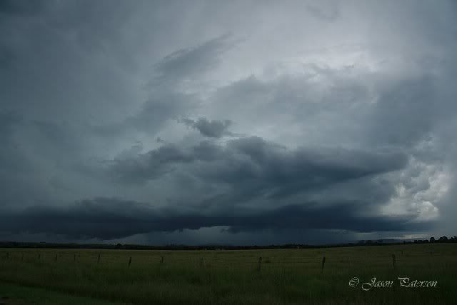
Development SW of Casino


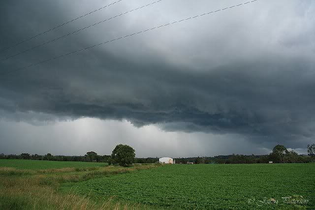
Decided to move further up the road towards Kyogle but the rain overtook me. Finally got clear of the precip and quickly snapped off another pic. The cell looked to be taking on a more intense appearance now.


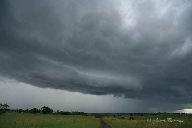
Was forced to move again and decided to take the turnoff to Lismore to get a bit further ahead of the rain. Once again it was a case of quick pic and take off again. Surpisingly I hadn't seen one CG at all, but I know they were there as indicated by the lightning tracker. They must have been hidden behind the rain curtain I'd say.


At this stage I decided to take a gamble and punch the cell. I encountered some very intense rainfall and a bit of gusty wind, but nothing too scary. I headed back into Casino and after a quick radar check it was apparent all the action was to the north and south, with the cells to the south moving SE and quickly getting out of chase range.


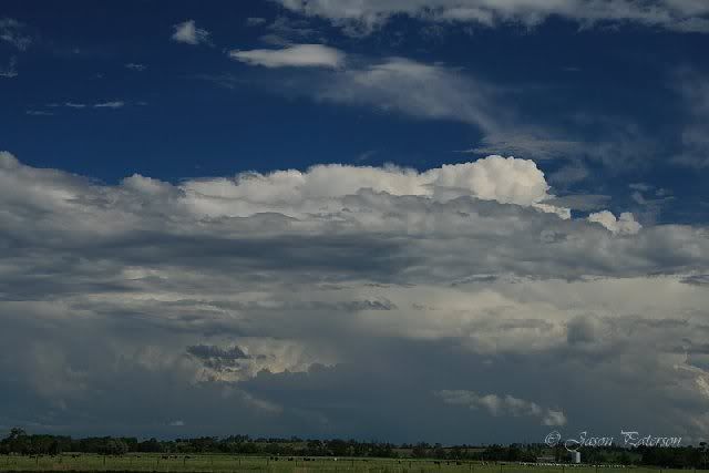
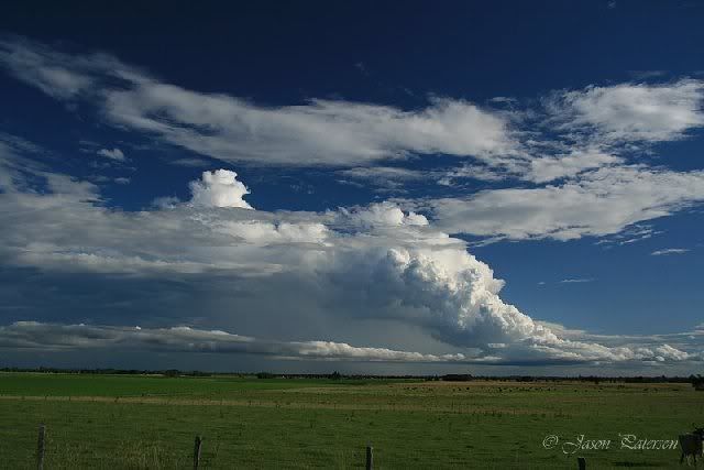
I decided to call it a day and head home via Roddy's new place at Springrove aka "SPRINGROVE STORM CORRIDOR", which is located between Lismore and Casino. Had another radar check at Roddy's place and it looked like we'd see nothing more in the NR's today so headed for home. On the way a cell to the south caught my attention so I decided to snap another pic for prosperity, It almost had a LP appearance at this stage, but it died pretty rapidly not long after this pic was taken.


Not an overly spectacular day by NR's standards but it certainly was refreshing to see a storm and hear thunder again. Looking forward to some more storms over the next few days.

Hope you enjoy

Cheers Jason
South Lismore, Northern Rivers NSW.....Supercells are us!!

Offline Richary

  • Barrel tornado F4
  • *
  • Posts: 680
  • Gender: Male
RE: NSW & QLD Severe Storms: 19 - 22 February 2009
« Reply #9 on: 20 February 2009, 03:54:17 PM »
While it wasn't spectacular in Sydney I did catch one photo of a nice cell that would have off the coast south of Cronulla, this was taken looking over the Cook's River at Tempe about 1:30pm. Later in the day I was down at Picton and had a partially obscured by other cloud rear view of a cell that was orange on radar over the southern edge of the Royal National Park that looked quite nice also.


Offline Antonio (stormboy)

  • Stove pipe F3
  • *
  • Posts: 481
  • Gender: Male
RE: NSW & QLD Severe Storms: 19 - 22 February 2009
« Reply #10 on: 21 February 2009, 06:55:37 AM »
A nice day so far a mixture of heat and humidity looks to be already at work as a storm cell has developed in the Bonalbo and Tabulam area smaller scattered cells are developing to as you can see below.

Offline habs

  • Rope Tornado F0
  • *
  • Posts: 5
  • Gender: Male
RE: NSW & QLD Severe Storms: 19 - 22 February 2009
« Reply #11 on: 21 February 2009, 08:05:37 AM »
Couple of photos from around cessnock yesterday. had the day off work so took a gamble and headed up there


Matt

Offline Colin Maitland

  • Barrel tornado F4
  • *
  • Posts: 614
  • Gender: Male
RE: NSW & QLD Severe Storms: 19 - 22 February 2009
« Reply #12 on: 21 February 2009, 09:52:48 AM »
Begining of the storms this afternoon, Northside of Brisbane, Warnings have been issued.
Some early shots, I have to take my girls to swimming squad so it could be an early swim session.
Time for new camera.
« Last Edit: 21 February 2009, 10:01:34 AM by coltan »

Offline Colin Maitland

  • Barrel tornado F4
  • *
  • Posts: 614
  • Gender: Male
RE: NSW & QLD Severe Storms: 19 - 22 February 2009
« Reply #13 on: 21 February 2009, 11:16:48 AM »
Got the girls to swimming and the EWN alet went off for severe storm just as I arrived, the youngest had about 10 minutes of swim before it was cancelled.
I took a few shots with my phone as it approached Bracken ridge, so the quality is not very good, just about as bad as the digital camera.

The storm basically has turned into a heavy downpour, just a few flashes of lightning and roars of thunder, a few seconds of wind and more rain.

Offline Richary

  • Barrel tornado F4
  • *
  • Posts: 680
  • Gender: Male
RE: NSW & QLD Severe Storms: 19 - 22 February 2009
« Reply #14 on: 21 February 2009, 02:08:00 PM »
Well tomorrow the forecast is for possible storms around the Sydney region. Has anyone worked out where things might fire up and be a good area to target tomorrow for some action?

From my very limited understanding of reading the available charts - the CAPE and LI for early afternoon looks promising to the NW of Sydney, probably west of or near the Putty region. Problematic chasing country. The aerological charts don't show any shear for here or Newcastle, but indicate a bit of an moist level around the 400mb region. In the absence of an obvious inversion would this equate to the cap for anything tomorrow?

Given the prevailing westerlies at altitude, would it be a reasonable assumption that storms could form NW of Sydney then track east towards say Lake Macquarie? Or are people thinking further north such as the Hunter?