Author Topic: NSW / VIC Storms: 2 - 5 Feb 2009  (Read 21461 times)

0 Members and 1 Guest are viewing this topic.

Offline Michael Bath

  • storm chaser
  • Administrator
  • Wedge tornado F5
  • *
  • Posts: 1,602
  • Gender: Male
    • Australian Severe Weather
NSW / VIC Storms: 2 - 5 Feb 2009
« on: 03 February 2009, 10:02:09 AM »
An interesting cell near Bombala now (4pm 2/2) tracking NE. Probably needed the elevation of the Alpine area to get something decent going today.

STW was issued by the BoM for large hail and damaging winds.
Location: Mcleans Ridges, NSW Northern Rivers
Australian Severe Weather:   http://australiasevereweather.com/
Lightning Photography:   http://www.lightningphotography.com/
Early Warning Network: http://www.ewn.com.au
Contact: Michael Bath

Offline Richary

  • Barrel tornado F4
  • *
  • Posts: 680
  • Gender: Male
RE: NSW / VIC Storms: 2 - 5 Feb 2009
« Reply #1 on: 03 February 2009, 12:03:59 PM »
That's looking pretty nasty near Numeralla at the moment!

Looks like I might be back in Brisbane Thursday-Friday. Have to check the forecasts.

Offline Ursula

  • Multi-vortex F1
  • *
  • Posts: 33
  • Gender: Female
RE: NSW / VIC Storms: 2 - 5 Feb 2009
« Reply #2 on: 03 February 2009, 03:10:55 PM »
The storms have passed here now, they would be near Braidwood, I don't think Braidwood itself will get a lot, looks like about 5 -10km east on both sides of the Kings Highway, the way it is tracking the Budawang Fire should get some hail as well, with 2000 ha burnt it can do with any help to cool it down, better check for Chimney's in the morning on the coastal ridge.
It started with a heavy gust and large hail, sounded like bombs on the roof, then small, melted quickly and lots of rain which is welcome. It has been lightening active. I got some pic's just before the storm hit, I never seen anything like it before, would like your info on it, after securing everything and made sure the animals are safe, I will have a look in the morning and see if the pic's turned out, electricity is a bit dodgy at the moment. It is still raining on and off and the occasional thunder.

Offline Peter J

  • Stove pipe F3
  • *
  • Posts: 419
  • Gender: Male
  • Lets go get em boys!
RE: NSW / VIC Storms: 2 - 5 Feb 2009
« Reply #3 on: 03 February 2009, 03:49:39 PM »
Did get some storms in Melbourne today around 11am - only 3mm of rain fell -which is welcome relief from the extreme heat of last week. Lound thundercracks were heard near home, but the "severe" element was missing - also no STW was issued here. Nice CGs flanged out, but daytime lightning is very difficult to capture on a mobile phone camera.

Big Pete

PJJ

rush

  • Guest
RE: NSW / VIC Storms: 2 - 5 Feb 2009
« Reply #4 on: 03 February 2009, 06:21:54 PM »
I'm in the NW of Vic. We miss this particular event.
« Last Edit: 04 February 2009, 01:19:48 AM by Jimmy Deguara »

Offline Michael Bath

  • storm chaser
  • Administrator
  • Wedge tornado F5
  • *
  • Posts: 1,602
  • Gender: Male
    • Australian Severe Weather
RE: NSW / VIC Storms: 2 - 5 Feb 2009
« Reply #5 on: 04 February 2009, 06:47:16 AM »
Quote
SES clean up Bombala storm damage
Tuesday February 3, 2009 - 12:09 EDT
State Emergency Services (SES) crews have been attending to damage caused by a severe thunderstorm on the Monaro yesterday.

Strong winds and large hail broke windows, brought down a tree and caused flooding when it struck Bombala just before 4:00pm AEDT yesterday.

Tony Casey from the SES says the storm cell formed quickly.

"Winds went southerly from about 20 kilometres per hour to an average of about 72 kilometres per hour in less than five minutes with gusts up to 98," he said.

- ABC


Satpic at the peak of the storm. 256km scale radar shows the cell passing over Bombala.


---> Canberra 128km scale radar loop

---> Canberra 256km scale radar loop


Location: Mcleans Ridges, NSW Northern Rivers
Australian Severe Weather:   http://australiasevereweather.com/
Lightning Photography:   http://www.lightningphotography.com/
Early Warning Network: http://www.ewn.com.au
Contact: Michael Bath

Offline Michael Bath

  • storm chaser
  • Administrator
  • Wedge tornado F5
  • *
  • Posts: 1,602
  • Gender: Male
    • Australian Severe Weather
RE: NSW / VIC Storms: 2 - 5 Feb 2009
« Reply #6 on: 04 February 2009, 11:08:15 AM »
A lot of thunderstorms in NSW this afternoon in a fairly low shear environment. Storms are backbuilding towards the NNW at times. There's quite a strong cell 25ks NW of Cowra at present (5pm 3 Feb).
Location: Mcleans Ridges, NSW Northern Rivers
Australian Severe Weather:   http://australiasevereweather.com/
Lightning Photography:   http://www.lightningphotography.com/
Early Warning Network: http://www.ewn.com.au
Contact: Michael Bath

Offline James

  • Elephant Trunk F2
  • *
  • Posts: 149
  • Gender: Male
    • Sydney Storm Chasers
RE: NSW / VIC Storms: 2 - 5 Feb 2009
« Reply #7 on: 04 February 2009, 11:13:30 AM »
Just noticed that before as well Michael. Usually a pretty strong storm to show up reflectives that strong away from radar. Wind shear on the Wagga and Nowra soundings today isnt too bad for organised storms in Southern NSW. Further north from there and it really drops off.

Some mid level anvils from the showers that developed over Lismore to Nimbin this afternoon. Sad I know but I got excited just seeing them after what feels like an eternity without a storm.

Offline nmoir

  • Elephant Trunk F2
  • *
  • Posts: 200
  • Gender: Male
  • "busting chases since 1999"
    • Oculi.com.au
RE: NSW / VIC Storms: 2 - 5 Feb 2009
« Reply #8 on: 04 February 2009, 02:05:42 PM »
Sorry bit late been very busy , here is a shot which appeared in todays Herald which I shot near Temora yesterday late afternoon , the storms were punching down some pretty strong microbursts including this one which put up a dust storm. they were all high based and put out some pretty nice lightning which incidently started a bushfire
« Last Edit: 07 February 2009, 12:00:45 PM by Jimmy Deguara »
Nick Moir
Photographer
The Sydney Morning Herald
and www.oculi.com.au

Offline Jimmy Deguara

  • Australian and Tornado Alley storm chaser
  • Administrator
  • Wedge tornado F5
  • *
  • Posts: 2,218
  • Gender: Male
  • Storm Chaser since 1993, Tornado Alley 2001
    • Australia Severe Weather
RE: NSW / VIC Storms: 2 - 5 Feb 2009
« Reply #9 on: 04 February 2009, 05:28:29 PM »
Hi,

Nice storm there Nick! What people may not realise is the chase yesterday for Nick although high based were in a region of steep lapse rates.

Report 3rd February 2009 (attempted) storm chase

As Michael suggested - storms about today. Actually too many storms such that they became ingested. The cap broke early as well leaving no time to take on the appointment and get out there in time. The storms pulsed and then weakened relatively rapidly in most cases. I did get a few small hailstones east of Oberon most likely from a developing cell under the main cell or from the anvil.

The pictures below are more for an indication of what occurred around the Oberon to Bathurst region and then Orange.


All photos for 3 February 2009

Regards,

Jimmy Deguara
« Last Edit: 06 February 2009, 04:02:51 PM by Jimmy Deguara »
-------------------------------------
Australian Severe Weather
www.australiasevereweather.com

Australian Thunderbolt Tours
www.thunderbolttours.com

Phone  0408 020468  (International :  61  2  408 020468)

Offline Michael Bath

  • storm chaser
  • Administrator
  • Wedge tornado F5
  • *
  • Posts: 1,602
  • Gender: Male
    • Australian Severe Weather
RE: NSW / VIC Storms: 2 - 5 Feb 2009
« Reply #10 on: 05 February 2009, 06:15:37 AM »
Seems that Young was in the firing like for one of the severe storms yesterday (3rd Feb). This story via the ABC.

Quote
Storm batters Young
Wednesday February 4, 2009 - 11:23 EDT
The town of Young is waking up to the damage caused by a severe storm last night.

Country Energy's regional manager, David Nardi, says the storm hit the town shortly before 7:00pm AEDT, wreaking havoc on electricity supplies.

Mr Nardi says it is the worst storm in the region for some time.

"We had about 2,500 customers affected. We progressively restored most of those customers by around 11 o'clock last night," he said.

"We brought additional crews in from surrounding regions to assist. They're hitting the ground this morning as well some of them arrived last night to work through.

"Severe winds brought down around 16 poles and scattered around the town itself and through the main CBD area.

"Locals say they've never seen a storm like that."

Mr Nardi says people should stay at least eight metres away from fallen powerlines or trees that are touching powerlines.

"We are working around the clock. We've got fresh crews arriving and we'll do everything possible to restore supply as soon as possible," he said.

Graeme from Young has rung ABC Riverina to describe to storm damage in his neighbourhood.

"We got 22 millimetres of rain in about 10 minutes including hail, very, very strong winds and a lot of rain, a lot of wind and there's a house not far from where I am where I walk the dog, it's had its roof removed," he said.

"There's big gum trees down, my backyard looks like a war zone with the leaves and what have you down in the yard.

"It was very wild and woolly for about 10 minutes."

- ABC
Location: Mcleans Ridges, NSW Northern Rivers
Australian Severe Weather:   http://australiasevereweather.com/
Lightning Photography:   http://www.lightningphotography.com/
Early Warning Network: http://www.ewn.com.au
Contact: Michael Bath

Offline Mike

  • Australian Severe Weather Moderators
  • Wedge tornado F5
  • *
  • Posts: 1,348
  • Gender: Male
  • Dry season here...boring!
    • http://StormscapesDarwin.com
RE: NSW / VIC Storms: 2 - 5 Feb 2009
« Reply #11 on: 05 February 2009, 08:45:27 AM »
Beaut storms there guys and like the dust kicked up by the rain shaft also Nick.  Saw the images on radar and on the tube yesterday and looked interesting.  Hope there was some relief from the heat for you lot on that side of the country.
« Last Edit: 06 February 2009, 08:11:26 AM by Jimmy Deguara »
Darwin, Northern Territory.
StormscapesDarwin.com
Lightning Research 2010/14

Offline Shaun Galman

  • Stove pipe F3
  • *
  • Posts: 441
  • Gender: Male
    • ridgelightning.com
RE: NSW / VIC Storms: 2 - 5 Feb 2009
« Reply #12 on: 05 February 2009, 08:57:36 AM »
Upper Western NSW. Storm Report 3rd February 2009.
Hi guys,
We had a great night a great and extremely active storm line push through last night! It came our way around 8:30pm up through Walgett approaching from the South (which doesn't happen too often here) By 9:15pm we were under a massive RFB with the front line still about 40k's South. I have to check the times but I think we shot out of town to meet it head on at 10pm-ish. Lightning was constant, not only were CG firing every second or two but several at a time all around us! I haven't seen so much widespread activity in ages, particularly as the activity held on for hours! I think we finished up photography around 2am.
There was a small amount of structure along the main cell, it carried a small shelf for a time and had some real nice inflow banding. I will get a few photos up once I've processed them.

Not much in the way of rain as we were right in a split, horseshoe shape type of setup.
To be continued.. :D

Regards,
Shauno

Chasing Region: Lightning Ridge. N.S.W.
Website: www.ridgelightning.com

Offline Jimmy Deguara

  • Australian and Tornado Alley storm chaser
  • Administrator
  • Wedge tornado F5
  • *
  • Posts: 2,218
  • Gender: Male
  • Storm Chaser since 1993, Tornado Alley 2001
    • Australia Severe Weather
Re: NSW / VIC Storms: 2 - 4 Feb 2009
« Reply #13 on: 06 February 2009, 10:32:24 AM »
Hi,

Good to see storms being intercepted and reported from across the viewing area and it seems NSW has been in thick of it in these episodes.

Report Storm Chase February 4 2009

I had planned for this day even rescheduling an pregnancy appointment to get to this event (such has been the desperation for storms).

I planned to meet Nick who was returning from a trip in the country (posted in this thread). The target was Lithgow to Oberon vicinity with GFS forecast model CAPE values exceeding 1600J/kg.

From Mt Victoria, the first cumulus developed near Jenolan-Oberon area so I ventured over there. The first storm developed from the first of this cumulus cluster. This storm remained weak so although I maintained some pace, I never gave chase. In fact, explosive updrafts further to the north west took my attention so I repositioned on the northern side of Oberon after reviewing my decision to give chase. I remained put to see what happened. I was able to wait for Nick as he had two flat tyres (he may explain further the reasons - sorry Nick:)).

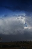
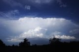
Almost simultaneous to Nick's arrival saw the weaker storm now hovering over Lithgow explode! We gave chase with Lithgow our target via Tarana. The tower punched through through the anvil and spread sidewards as a thick chunky anvil! By the tuime we made it to Lithgow at least half an hour, the cell was weakening.

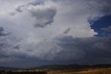
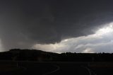
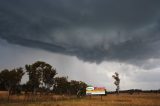
A second major updraft had already begun exploding to its northwest near the Mt Piper Power Station which we were in positon to pursue. The cell was already quite organised and had moderate northeast inflow and hailstones were dropping from the preciptating front portion of the updraft as well as the southern side. We reporisitoned north to near Cullen Bullen for timelapse. On the way, we were splattered with isolated hailstones and a couple of bright lightning bolts.

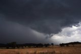
It was great to finally be able to relax and feel at ease with the storm at a safe and comfortable distance. We were under an organised rain free base with possible rotation. Active lightning occurred mainly within the preciptation core. Gradually the storms hail shaft hid the hills to our south with a veil of white and with sprinkles of rain, I suggested to Nick we sample the core (he was drooling for the opportunity!).

Perhaps 2 kilometres of chasing south and the hail opened up in torrents. Hail measuring perhaps up to 3 to 4cm in diameter (estimated) pelted the vehicles. It was such a great feeling given the poor storm season. After about 10 minutes of the hail, it eased so we headed north once more. The structure was still consistent and organised though we could now see through the hail core. It became increasingly difficult to observe the storm with spits of rain so we entered the core one more time. This time the storm collapsed rapidly venturing into the Wollemi.

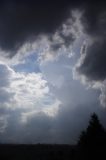
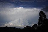
After some time contemplating whether to head home or await mammatus pictures, I took interest in the explodng updrafts to the north near Rhylestone Nick had noticed earlier. After some time traversing these storms the storms collapsed rapidly. We decided it was getting late and needed to head home. We had made up all the way to Bylong.

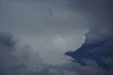
A few pictures from the chase below. The first set of photos outline the chase to the first updraft explosion. Then the second phase represent the second updraft and base structure followed by the anvil reflection of the Rhylstone storm event.

The whole sequence for photographs of the day are on this page


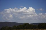
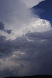
Episode two beginning with the new exploding updraft northwest of Lithgow


Regards,

Jimmy Deguara
« Last Edit: 06 February 2009, 12:29:54 PM by Jimmy Deguara »
-------------------------------------
Australian Severe Weather
www.australiasevereweather.com

Australian Thunderbolt Tours
www.thunderbolttours.com

Phone  0408 020468  (International :  61  2  408 020468)

Offline Dave Nelson

  • Elephant Trunk F2
  • *
  • Posts: 172
  • Gender: Male
    • Stormy Sydney
Re: NSW / VIC Storms: 2 - 5 Feb 2009
« Reply #14 on: 06 February 2009, 03:40:20 PM »
Hi Gang,

   been too busy to report before now....

  Tuesday 3rd Feb.   Cindy and I followed several nice pulse storms south of Campbelltown ( in the general Picton
area)   These storms didn't really come off the mountains  ... rather they moved short distances northwards along
the hills before dissapating and new cells forming.

 Thursday 5th Feb.   Again I chased several pulse storms south of Campbelltown, and just like Tuesday they
didnt leave the mountains  The main cell over Picton (today 5th) got to a good peak with many CG's seen.

cheers
Dave N