Author Topic: NSW / VIC / QLD Storms 20-26 January 2009 and whinge thread  (Read 80550 times)

0 Members and 1 Guest are viewing this topic.

Offline Kristy Norman

  • Elephant Trunk F2
  • *
  • Posts: 120
  • Gender: Female
RE: NSW / VIC / QLD Storms 20-26 January 2009 and whinge thread
« Reply #75 on: 26 January 2009, 02:40:18 PM »
Shaun, those storms are absolutly beautiful. The stars together with the storms...It looks amazing!
« Last Edit: 27 January 2009, 01:10:23 AM by Jimmy Deguara »

Offline Rodney Wallbridge

  • Multi-vortex F1
  • *
  • Posts: 71
  • Gender: Male
    • Red Bubble
RE: NSW / VIC / QLD Storms 20-26 January 2009 and whinge thread
« Reply #76 on: 26 January 2009, 03:44:12 PM »
Gyday all, went out for a chase with Michael Bath and Jason(Pato). Headed out to Tenterfeild and then on to Warwick which is in QLD  :eek:  The trip total time was 13hrs with 636kms travelled.Driving time was 8hrs. Some fantastic examples of Pileus caped updrafts and some on overshoots. Stacatto Cg's were lovely and scenery was quite nice too.
The setup clearly supports ranges storms which should have been alower moving then what they were?
Really enjoyed the company and the chase even if we did get home after 1am  :cool: here are a few of my favorite pics. Great storms everyone who got amongst them!! Last picture shows Lightning Lady looking down on us


« Last Edit: 27 January 2009, 01:08:39 AM by Jimmy Deguara »

Offline Jimmy Deguara

  • Australian and Tornado Alley storm chaser
  • Administrator
  • Wedge tornado F5
  • *
  • Posts: 2,218
  • Gender: Male
  • Storm Chaser since 1993, Tornado Alley 2001
    • Australia Severe Weather
RE: NSW / VIC / QLD Storms 20-26 January 2009 and whinge thread
« Reply #77 on: 26 January 2009, 03:52:14 PM »
Wow! Nice storms intercepted with obvious outflow and shelf clouds. Active storms during the evening. I forgot to mention that last night, I saw a couple and filmed one bolt come right out of the storm and strike ground. Today, there were a few as well.

Chase report January 25 2009

Still with family and having stayed overnight at Forster, we headed up towards and beyond Dorrigo and Ebor. The cloud gave way to cumulonimbus to the west of Ebor. I targeted Guyra and basically when we got there, storm intensity increased and a couple of storms organised. The first to the south and southeast of Guyra put up a nice updraft and base with nice base organisation before it produced outflow and got undercut by the boundary it perhaps developed on.

Observing developing storms to the northwest, I decided to quickly re-position - this time over the Ben Lomond range. The rain free base of the storm looked to be getting inflow so I set up for timelapse and photographs. The storm produced some sporadic bolts and an arcus cloud developed the base. Some deep thunder could also be heard from within the core.

Repositioning near Glencoe, I observed some good organisation but the contrast was not ideal and the hills were in the way for observation of the base. I have timelapse from this vantage point and further down the road towards Glen Innes - though the storm was on a downward trend. We are staying the night in Glen Innes.


All photos for 25 January 2009

Regards,
Jimmy Deguara
« Last Edit: 28 January 2009, 06:08:17 AM by Michael Bath »
-------------------------------------
Australian Severe Weather
www.australiasevereweather.com

Australian Thunderbolt Tours
www.thunderbolttours.com

Phone  0408 020468  (International :  61  2  408 020468)

Offline Richary

  • Barrel tornado F4
  • *
  • Posts: 680
  • Gender: Male
RE: NSW / VIC / QLD Storms 20-26 January 2009 and whinge thread
« Reply #78 on: 26 January 2009, 06:49:24 PM »
Back from Brisbane now. Saturday night I could see distant flashes in the sky from the severe cell that had moved over near Toowoomba and been already documented here - some great photos guys.

Today nothing in Brisbane though Coolangatta flights were on hold or diverted due to thunderstorm activity that way, and we took a more westward track than usual from Brisbane dodging them leaving at 4pm. I see Byron got a fair bit of rain and someone told me Coolangatta got a good dump as well. Nothing spotted from the plane though an aisle seat and cloud under us most of the way to Sydney.

Offline Harley Pearman

  • Barrel tornado F4
  • *
  • Posts: 584
RE: NSW / VIC / QLD Storms 20-26 January 2009 and whinge thread
« Reply #79 on: 27 January 2009, 05:24:47 AM »
Singleton / Muswellbrook Storms 24 January 2009

Saturday 24/1/2009, I took a trip up to Singleton (Hunter Valley) to see what would happen and finished up staying the night there after photographing night time lightning.

I was concerned at first when reaching this area because of the heat (It reached 41C - 106F) Saturday and the high cirrus cloud cover at first. That cleared early afternoon. With no storms in sight and a late afternoon / evening cool change, I decided to stay in the area for 3 hours watching the sky. That paid off late afternoon especially as the cool change approached from the south.

After 3 pm, thunderstorms started to develop with the first storm developing almost over me. My first photo shows this small but quite pretty storm cell being the second one for the day and located about 2 km south east of me. The cloud tower shot out a cloud to ground lightning strike not too far away from me and the thunderclap permeated through the cloud. It shows that even such a tiny storm cell as this can produce cloud to ground strikes. The photo was taken at Rose Point Park off Ryan Avenue Singleton but I missed capturing the lightning strike.

Following the first two small storms at Singleton, I then headed north west towards Musselbrook. I was going to see if I could catch up with another storm as seen in the second photo. This put up a lovely anvil shield at first and I saw 2 cloud to ground lightning strikes however upon getting closer to it, I discovered that it was passing through inaccessible country to my north east. I then pulled off the New England Highway and took a series of short video film and photos of the rear portion including its base. I am located near Ravensworth.

Following this, I saw more intense thunderstorms develop to my SE so I then drove 30 km towards Whittingham and captured numerous shots of a more intense thunderstorm plus lightning strikes. I spent quite a while outdoors getting lightning photos at dusk and into the early evening. I post some of my favourite ones for the day.

This part of the Hunter Valley plus areas toward Newcastle did fire storms thanks to the cool change at the end of the day. I spent the night in Singleton before returning home Sunday morning.


Harley Pearman

Offline Macca

  • Elephant Trunk F2
  • *
  • Posts: 171
RE: NSW / VIC / QLD Storms 20-26 January 2009 and whinge thread
« Reply #80 on: 27 January 2009, 04:24:25 PM »
Hi all,

Went for a bit of a drive (550km) out to Inglewood and back.  Although not as unstable as the two days prior due to lower moisture levels, the shear profile was interesting and I think I was more curious than anything to see what the storms would look like.  850mb winds were ESE'ly, 700mb winds were SE'ly and 500mb winds were S'ly.  These were all sitting under a SW'ly jetstream.  None of the levels were overly strong with 850 winds being 10-15knts, 700mb being 15-20knts, 500mb being 20-25knts and the jet being 35knts or so. 

Anyway - so after driving through some moderate to heavy rain from the inner western suburbs of Brisbane all the way to Cunningham's Gap, I finally broke through into clearer, unstable skies.  I continued to Warwick and then headed west to Inglewood to have a look at a storm coming up from near Stanthorpe.  It was disorganised and messy and died not long after it went over Inglewood.  I stayed around the area not really knowing what to do and it looked decidedly crappy but I stuck it out anyway as it was quite warm and humid. 

TCu bubbled away to the SE and W of me and finally the TCu to the SE was of sufficient size that it broke through the warm(er) layer just above 500mb (which prevented storms from being better than they were).  I gave chase (not far) to the east and drove through the featureless western side and broke through to see a nicely shaped base on the south eastern flank (almost overhead).  I stopped the car at a convenient little clearing and there was constant rumbles above my head.  The storm was being fed by cool but quite humid ESE'ly winds and whilst it looked nice and had some decent lightning, it was ingesting some pretty unhealthy air (for storms) and as it moved further NW, it weakened and didn't look too good so I left it be and headed back to Brisbane.

Overall an interesting drive and it was interesting seeing the storm/s with bases on the south eastern flank.  It was like chasing US-style storms (in terms of looks and directional shear only) and was an interesting lesson in seeing what happens when storms ingest cool air. 

Pics from today are here....http://macca.bsch.au.com/gallery2/v/Season+08/260109/

Macca

Offline Peter J

  • Stove pipe F3
  • *
  • Posts: 419
  • Gender: Male
  • Lets go get em boys!
RE: NSW / VIC / QLD Storms 20-26 January 2009 and whinge thread
« Reply #81 on: 27 January 2009, 05:42:38 PM »
No storms here in Outer-East Melbourne, and none forecast for VIC until Wed, when some storms may occur over the East Gippsland region.

Instead, like SA, we are about to embark on a solid heat wave, with temps exceeding 40C for the next 4 days - not the kind of weather one wants to have when the kids go back to school.

Big Pete
(hot enough to fry an egg on me scone)

PJJ

Offline Jimmy Deguara

  • Australian and Tornado Alley storm chaser
  • Administrator
  • Wedge tornado F5
  • *
  • Posts: 2,218
  • Gender: Male
  • Storm Chaser since 1993, Tornado Alley 2001
    • Australia Severe Weather
RE: NSW / VIC / QLD Storms 20-26 January 2009 and whinge thread
« Reply #82 on: 27 January 2009, 06:31:43 PM »
Hi Macca,

As discussed this morning during our brief chat, we were already in what seemed to be our target. However, it once again became somewhat frustrating at least for a little while trying to pick the weather conditions and to position yourself with the cumulus that may rapidly develop into storms.
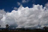
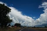
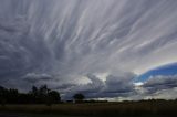
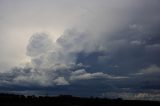
Chase Report January 26 2009

The early storms glaciated but remained weak with a few rumbles of thunder. Eventually, I saw anvil to the south and so I gave chase just to see what was going on. With the storm near Black Mountain south west of Guyra, I could make out an interesting base briefly but never again did I get an opportunity. The feature most likely had to be scud rising to the base. After a little while, I noted that winds were cooler east to south easterly. So I headed on the road to Inverell. Convection was teasing to the north probably on the border. But after a little while, I noted the anvils were transparent indicating multiple updraft histories. The anvil to the northwest though was more substantial indicating some 'relatively' explosive activity. By the time I got to 10km south of Inverell, a nice structure of a right moving cell came into view. I am not sure whether it had split but it was in a weakening phase. I tried to chase the cell retreating to the west but after about 30km W of Inverell, I let it go. It seemed to weaken and I was not enthused by the south to southwest winds in the area even if it was from outflow.

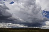
It was near Inverell that another area of convection intensified. The two cells seem to merge and positioning on the road to Ashford, I watched as a nice base developed and precipitation curtains approached. Hail to pea sized or perhaps even 1cm was observed as I punched the core in Inverell. Gusty winds accompanied the hail.

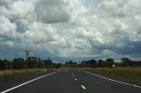
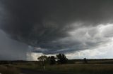
By the time I headed on the road to Yetman, the storm was in decline with outflow undercutting the original storm and producing new updrafts. With limited heating and also disrupted moisture source, the cells were never impressive.

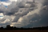
The return of moisture during the evening encouraged the development of weak cells. We called it a day and had dinner at Inverell. Whilst awaiting the dinner to be served, I took the opportunity to get a few more photographs.

As Macca said, I too was interested in the way the shear would react and which storms would dominate.

However, it seems that the anvils also cut off the heating on the eastern side and many cells competed for what energy was available. A stronger cap would have been ideal and more energy.

Following are some of the images for today:


« Last Edit: 28 January 2009, 05:22:10 AM by Michael Bath »
-------------------------------------
Australian Severe Weather
www.australiasevereweather.com

Australian Thunderbolt Tours
www.thunderbolttours.com

Phone  0408 020468  (International :  61  2  408 020468)

Offline Jimmy Deguara

  • Australian and Tornado Alley storm chaser
  • Administrator
  • Wedge tornado F5
  • *
  • Posts: 2,218
  • Gender: Male
  • Storm Chaser since 1993, Tornado Alley 2001
    • Australia Severe Weather
RE: NSW / VIC / QLD Storms 20-26 January 2009 and whinge thread
« Reply #83 on: 27 January 2009, 06:38:02 PM »
After the chase ended, further pictures were taken from within or near Inverell.


All photos for 26 January 2009

Regards,
Jimmy Deguara
« Last Edit: 06 February 2009, 03:15:58 PM by Jimmy Deguara »
-------------------------------------
Australian Severe Weather
www.australiasevereweather.com

Australian Thunderbolt Tours
www.thunderbolttours.com

Phone  0408 020468  (International :  61  2  408 020468)

Offline David C

  • Global Moderator
  • Barrel tornado F4
  • *
  • Posts: 643
  • Gender: Male
    • Thunderbolt Tours Storm Chasing Adventures
Re: RE: NSW / VIC / QLD Storms 20-26 January 2009 and whinge thread
« Reply #84 on: 29 January 2009, 11:07:36 AM »


31/21 here.

Dann

Dann, now that is what I call instability  - what a top photo - when was that, has January 2004 crispness? (sorry for off-topic)
Storm Chaser,
Thunderbolt Tours - USA & Australia Storm Chase Tours
www.thunderbolttours.com

Offline Colin Maitland

  • Barrel tornado F4
  • *
  • Posts: 614
  • Gender: Male
Re: NSW / VIC / QLD Storms 20-26 January 2009 and whinge thread
« Reply #85 on: 29 January 2009, 01:00:40 PM »
That looks like the someone has been testing atomic bombs again in the Atolls.
Brilliant photo.
« Last Edit: 07 February 2009, 12:07:50 PM by Jimmy Deguara »

Offline Michael Bath

  • storm chaser
  • Administrator
  • Wedge tornado F5
  • *
  • Posts: 1,602
  • Gender: Male
    • Australian Severe Weather
Re: NSW / VIC / QLD Storms 20-26 January 2009 and whinge thread
« Reply #86 on: 29 January 2009, 02:21:59 PM »
David - that is the LP --> Classic supercell that developed just SW of Lismore on 30th December 2008. It powered on out to sea for several hours. Dann's photo is the nicest one I've seen of it offshore.

Check out this thread
Location: Mcleans Ridges, NSW Northern Rivers
Australian Severe Weather:   http://australiasevereweather.com/
Lightning Photography:   http://www.lightningphotography.com/
Early Warning Network: http://www.ewn.com.au
Contact: Michael Bath

Offline Rhett Blanch

  • Rope Tornado F0
  • *
  • Posts: 9
  • Gender: Male
Re: NSW / VIC / QLD Storms 20-26 January 2009 and whinge thread
« Reply #87 on: 29 January 2009, 06:06:16 PM »
Some great photos.  I chased just North of Tamworth on the evening of the 24th of January after a hot and steam afternoon. I would have preferred to have got more to west of the line rather than to the southern side of the storms but that proved difficult with the absence of a key bridge due to the floods late last year.  The lightning activity was spectacular, refer to Gordon Garrard's time lapse if you can, although to much cloud to cloud activity from my viewpoint. The one that did leave the cloud, which was then quite some distance away, ended up being way too close when the "ting ting" noise I could hear from nearby fence posts resulted in a CG hitting said fence not that far from where I was parked in the car.


Cheers
Rhett

Offline Michael Bath

  • storm chaser
  • Administrator
  • Wedge tornado F5
  • *
  • Posts: 1,602
  • Gender: Male
    • Australian Severe Weather
Re: NSW / VIC / QLD Storms 20-26 January 2009 and whinge thread
« Reply #88 on: 30 January 2009, 01:48:14 AM »
Which bridge is out Rhett ?

The timelapse by Gordon is available here: http://members.ozemail.com.au/~loomberah/

Location: Mcleans Ridges, NSW Northern Rivers
Australian Severe Weather:   http://australiasevereweather.com/
Lightning Photography:   http://www.lightningphotography.com/
Early Warning Network: http://www.ewn.com.au
Contact: Michael Bath

Offline Rhett Blanch

  • Rope Tornado F0
  • *
  • Posts: 9
  • Gender: Male
Re: NSW / VIC / QLD Storms 20-26 January 2009 and whinge thread
« Reply #89 on: 30 January 2009, 02:02:41 AM »
The Somerton Bridge across the Peel is closed as it was partially washed away.  I had a choice of dirt road (not a good idea at night in the rain) or driving all the way back into Tamworth and then back out to get to the area around Somerton.  Decided to stay put.