Author Topic: NSW Severe Storms 2 - 4 January 2011  (Read 39114 times)

0 Members and 1 Guest are viewing this topic.

Offline Antonio (stormboy)

  • Stove pipe F3
  • *
  • Posts: 481
  • Gender: Male
NSW Severe Storms 2 - 4 January 2011
« on: 03 January 2011, 03:16:46 PM »
Well first of all it is good to be back after a long and hooot drive, to make it even better from kempsey to Grafton we had some nice cells developing.

first shots are early convection the last one was at Grafton.

there were storms in Sydney too.
See : 128km Radar Loop for Sydney (Terrey Hills), 02:00 02/01/2011 to 19:00 02/01/2011 UTC


See : 128km Radar Loop for Grafton, 00:00 02/01/2011 to 07:00 02/01/2011 UTC


Antonio.
« Last Edit: 03 January 2011, 03:25:10 PM by Antonio (stormboy) »

Offline Harley Pearman

  • Barrel tornado F4
  • *
  • Posts: 584
Re: NSW Severe Storms 2 - 4 January 2011
« Reply #1 on: 04 January 2011, 02:07:32 AM »
Storm chase including hailstorm - Mt Bell / Cullen Bullen Sunday 2 January 2011

An account of a storm chase in the Blue Mountains is provided below.

Sunday afternoon, thunderstorms developed over the Blue Mountains west of Sydney. Early afternoon, I drove up towards Mt Bell via Bells Line of Road to intercept two storms building near the crest of the Blue Mountains. I had a short stop at Bilpin to observe a northern storm that was also developing. It was not possible to chase it as it was over national park with no roads into the area. I continued west over and around Mt Bell where I stopped in a clearing to observe two storms that were relatively close. A cell was to the north and another cell was to the south.

Both storms were building fast with the southern cell moving north east toward me. Simultaneously, the northern storm was also building to the east and west and both storm cells eventually merged into one another over and around Mt Bell and effectively overhead. Following this, there was a burst of cloud to ground lightning within my vicinity making it far too dangerous for me to be outside. I retreated back to the safety of the car where I had to stay for a while. One bolt was very close to me.

The rain held off for a while as the storm continued to build and enlarge over and around Mt Bell but when it did occur, a significant downpour resulted followed by a burst of small hail. At first the hail was pea size but became larger to 1 cm in size then 2 cm in size. A heavy burst of hail ensured. This was followed by some larger hail of between 2 and 3 cm in size. Hail was bouncing off the ground and it was hitting the car hard. A few large stones caused some very minor dimples onto the car roof and bonnet. I managed to get out of the car to retrieve one hailstone that was close enough and took a photograph of it in my hand. However I did get wet in the process of doing this and I felt the hail and rain hitting me.

This intense storm sustained hail bursts for a considerable time before it eased. I then sent Jimmy a text message to alert him of this storm cell and its position on Bells Line of Road. Following that, another burst of heavy rain occurred.

I then received a telephone call from Jimmy who advised me of another storm nearer to Mt Victoria. I then drove towards Mt Victoria and intercepted the storm. That storm also produced some cloud to ground lightning although much less than the earlier storm and small hail to pea size. The hail was much smaller than that of the earlier storm.

Following that, I was driving towards Mt Victoria and received a call from Jimmy who was at a lookout at Mt Victoria. I met up with Jimmy and we both drove to Lithgow, then onto the Castlereagh Highway towards Cullen Bullen where we intercepted another significant storm that was producing cloud to ground lightning.

I think I was given the challenge as to whether I would be brave enough to drive into it given the cloud structure being observed. I am pleased to say, I did follow Jimmy into it but I had to slow down due to the amount of rain and water lying across the road. I encountered very heavy rain, small hail and high winds. I was expecting larger hail but surprised only to find the hail at the time was smaller than that I experienced earlier in the day. I also encountered water cascading over the road, the odd tree that had been brought down and much leave and bark litter in places. On its northern side, I stopped to photographed more cloud structure and went back to photograph a downed tree that I passed earlier.

I was not sure where Jimmy went after that but I could not keep going further north. I had to go back to Sydney following the last storm as I had no clothing or overnight bag to stay out at a motel/hotel and I was hungry. Given the storms and hail that I encountered, I had an enjoyable afternoon. I want to say thank you to Jimmy for helping me to make this chase more enjoyable than I initially anticipated.

I will upload some 12 photos of the chase from early in the day to early evening in sequence across three posts. I am using my new Canon SX30 Power shot (14.1 Megapixel) camera. With higher resolution and higher quality, I am limited to 3 or 4 photos per post.


Harley Pearman
« Last Edit: 04 January 2011, 02:13:00 AM by Harley Pearman »

Offline Harley Pearman

  • Barrel tornado F4
  • *
  • Posts: 584
Re: NSW Severe Storms 2 - 4 January 2011
« Reply #2 on: 04 January 2011, 02:15:12 AM »
More photos of storms (2nd post) Dated 2/1/2011

As per my first post, please find attached, more photos of the storms for 2 January 2011.

Harley Pearman

Offline Harley Pearman

  • Barrel tornado F4
  • *
  • Posts: 584
Re: NSW Severe Storms 2 - 4 January 2011
« Reply #3 on: 04 January 2011, 02:22:08 AM »
Photos of storm near Cullen Bullen 3rd Post) 2/1/2011

As per my first post, the photos of the intense storm near Cullen Bullen are attached below.

Harley Pearman

Offline James

  • Elephant Trunk F2
  • *
  • Posts: 149
  • Gender: Male
    • Sydney Storm Chasers
Re: NSW Severe Storms 2 - 4 January 2011
« Reply #4 on: 05 January 2011, 12:23:28 PM »
I’m in Sydney for a couple of weeks on holiday so couldn’t say no when Dann mentioned the idea of chasing Monday. GFS seemed to be all over the shop with every second run changing the forecast DP from 19 down to 15 and vice versa. Both Access models were pretty consistent with 18-20 DP's so a quick adjustment of the forecast soundings showed some pretty nice instability and good shear - enough for severe organised storms. 850 temps were stronger towards Dubbo which meant capping was a lot stronger suppressing convection and allowing energy to increase for explosive storms that evening.

Our plan was to sit just east of the dry line and wait out for convection to start. Target area was the Parkes/Dubbo/Molong triangle with the town of Yeoval chosen to base ourselves. Yeoval is quite high up with great 360 degree views and the option to move in most directions if needed.  We were aiming to latch onto storms from around Yeoval and follow these north-eastwards to Gulgong/Dunnedoo where a good road network is available. 

We left the Mountains mid morning and intercepted the first line of storms coming into Orange around lunchtime (The main line that went onto the coast). Nothing too flash in terms of structure however lots of strong outflow with further storms developing on the edge of the outflow as it headed east. Whilst tracker was showing a massive amount of lightning, it seemed (from our point of view) most of this was hidden by precip. We continued on from here to Yeoval where we watched convection bubble away but failing in its attempts to sustain itself.

Storms developed early afternoon towards Molong and Orange so we headed south 30kms to Cumnock to get a better view of two of them as our area was still yet to fire. There was some nice base structure with wall clouds on both storms however they moved off into the unchaseable regions of Hill End. Outflow from these storms surged northwards kicking up more towers  around Hill End. These formed into storms and moved towards Ilford/Mudgee later afternoon.

Westerly winds started to push through Cumnock whilst we watched the Molong storms. We knew at that point we needed to head to Wellington as the convergence line was now on top of us. Cumulus started to re-build towards Yeoval so we headed north to Wellington and crossed to the eastern side of the convergence line. Upon arriving into Wellington we could see cumulus now towering on the convergence line just to our west.


Winds in Wellington started to pick up from the NE in strength as the towers started to anvil out. Temp DP was currently 31/21, very impressive obs! Over the next two hours we watched the towers build up into one monster storm that moved NE-NNE towards Dunnedoo. 


Near Goolma the storm developed a serious RFD that pushed a shelf cloud to the north with an inflow band stretching around 20 kms to the North-east into the base. Anvil rain spread off to the east-south-east and surface winds were now gusting around 30-40km/h from the north east. The Wall cloud under the base went through transitions from outflow to inflow as surges would push out further to the north. 


With the storm now taking a more northerly direction we needed to head north. Goolma Road headed north-west so wasn’t an option so we took Mebul road north to Spring Ridge road which finally sent us north towards the golden highway.  Mebul road wasn’t in great condition however the Subaru handled the road perfectly and we pulled onto Spring Ridge road skirting with the outflow winds from the RFD and 2-3cm hail.  From here we finally pulled ahead of the storm only to be greeted by a new storm that developed over the Golden Highway sw of Dunnedoo.  This new storm effectively killed our storm as warm moist inflow winds were replaced with cool moist outflow winds, not what is required for sustained storm development. Sure enough coming into Dunnedoo the storm weakened with the newer northern storm taking over. We toyed with the idea of heading further north to follow it however there were older showers and storms all through the north meaning it wouldn’t survive long if we did.  I should note winds at Dunnedoo were gusting around 40-50km/h from the north east – very impressive!


Another higher based but lightning active storm moved towards Dunnedoo from the sw shortly after. Some great CG’s however all of them eluded our camera efforts. Newer weaker storms kept on developing on the convergence line to the west producing some more rain/small hail, occasional lightning and a nice roll cloud, however nothing worth going after.


We headed to just east of Dubbo hoping for a nice sunset. We weren’t disappointed!


It was a great feeling having everything fall into place as expected and chasing the probable supercell from Wellington to Dunnedoo.

Offline pingtang

  • Multi-vortex F1
  • *
  • Posts: 70
  • Gender: Male
    • Southcoastweather
Re: NSW Severe Storms 2 - 4 January 2011
« Reply #5 on: 05 January 2011, 06:09:12 PM »
I chased storms on both the 2nd and 3rd of January.

Day 1 was a particlary frustrating day for me as opposed to Lightning Chaser who scored some epic CGs near Bathurst. We both planned on targeting the Bathurst/Oberon general area but decided to go in seperate cars( we commenly do this now to get more footage) .Unfortunately I left an hour later than Lightning Chaser,and as a result the Southern Highlands storms distracted me. The highlands storms weren't too shabby at all. The first one was very weak with bad contrast but it dropped out some clear air cgs. The next couple of storms around Bowral/ Mittagong we're much better storms, but with the southerly nearby they were never going to last long. The southern cell around Moss Vale contained a nice RFB which rapidly gave way to torrential rain and small hail. The frustating thing was the lack of CGs at the front of the storm, nearly all of them were embedded in the rain or behind the storm. The storm rolled over top of me,so I attempted to reposition to Mittagong for the northern storm( another drak red/black cored storm) Driving in the core of the Moss Vale storm was quite fun with torrential rain and small hail, 1 to maybe 2cms.During the core punch, I took a corner too quickly,and nearly spun off the road. I saw some nice CGs whilst driving through Mittagong,but it was becoming obvious that the storm was decaying rapidly. I pushed further north to Picton, where I witnessed a decent little pulse storm 20kms to my west. Unfortunately the storm decayed, but it did produce non-stop anvil thunder over my head(which was nice to listen to)and a few pulsing CGs, though too far for decent footage.

With the southerly chasing me, I decided to push onto Penrith where I waited for a good half hour or so, hoping the line of storms south of Katoomba would make it to me. At about this stage, I rang Lightning Chaser who was scoring some brilliant pulsing bolts near Bathurst at the time. I got impatient and decided to drive towards the Blue Mountains storms.What I didnt anticipate was a full blown scud fest which lasted until Lithgow. This mean't that I saw nothing,and this left me very frustrated. I pushed towards Mudgee where I witnessed heaps of very distant CGs to my east from Pearsons lookout(way to far away for video). I got a nice sunset however, but not much else. A fairly frustrating chase day. 3/10 Went back to Bathurst for the night.


Day 2- A lightning active storm near Lake Cargeligo saw us both on the road early. We left Bathurst at 7am,and checked the internet/models in Orange at 8am. The storms to the west were looking quite handy, however it was only early in the day. Wanting a good road option to the Mudgee/Gulgong area we decided to head north to Wellington where we stayed for all morning and into the afternoon. Watching the storms fire to the south was quite painful considering we were in the exact area just hours earlier,however we had to stick with our target area.

A second storm at middayish around Orange looked particulary nice,and another juicy storm was evident to our southeast towards Bathurst.Meanwhile the sky in our area was very primed for storms with heaps of blue sky and castellanus about.We had to remind ourselves that it was only 1pm which is still early. 2pm came and still nothing around wellington. Another storm was developing to our southwest(yet again)near Cumnock. I was confident I could intercept a storm if I went south,so thats what I did. I got to within 20kms of the storm,but the road took me away from it. I made it down to Molong and realised I was making a horrible mistake. Here I had a decent storm to me east with CGs but it was rapidly moving away from me. Meanwhile the sky above me and too my west was looking crook all of a sudden. I realised the trough was directly overhead,and moving to my northeast.There was no way I was giving up on the chase,so I booted it back to Wellington at 120clicks.

The sky at last began to look interesting around Wellington with the cap breaking at last,however I wanted to push east to Gulgong. About 20kms northeast of Wellington I noticed a rapidly developing base to my west,so I backtracked to almost Wellington again. This storm was slapping out the occasional clear air CG with nice booms. I met up with Lightning Chaser again and a drove down a road which takes you to a town 30kms southeast of Wellington.About half way down the road,we noticed that the Wellington storm was beginning to look real intersting with a lovely base and some rotation. This was the beginnings of the Gulgong/Dunedoo storms. Unfortnately this storm was moving into an inconvenient area for us,so we aborted. Considering there was decent shear about we had no chance of getting it( we would've had to backtrack 15kms west to Wellington,and then back east again) Another severe storm was developing just 10kms to our south,so we intercepted that. This storm contained some lovely greenage,and was chucking plenty of cgs. I decided to push in close to the storm,hoping for some flangs. I got some nice cgs 2-3kms on video but not the elusive flang that i've been after. This storm produced torrential rain,flash flooding,and some hail to 2-3cms. Unfortunately it was decaying,so we gave up on it,and headed back to Wellington. Here we came across a very rapidly devloping base.In almost no time,it went from base to full on deluge. We pushed eastwards to keep ahead of it,briefly pulling over to film at times. Some nice cgs at times,but a fairly ordinary storm.

20kms from Gulgong,we came across a tree which had completely blocked the road. I was happy to wait,as a truck was already clearing it,however Lightning Chaser headed back to Wellingon. In no time,the road was clear so I headed south towards Mudgee. Here I noticed more continuous thunder to my west.A brilliant shelf cloud was coming into into view about 20kms to the west above some hills,and some brilliant CGs were throwing out ahead of it. Another storm to my south was also dropping CGs,mostly clear airs which were hitting 3kms to my east!!!!


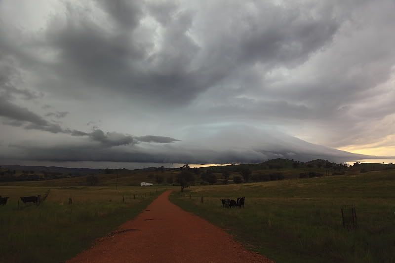
Eventually the best part of the storm was heading towards the Gulgong area,so I repositioned to that area encountering a nice barrage of a dozen or so CGs 2-3kms away.This storm decayed rapidly,leaving a spectacular sunset in its wake.

Whilst, I missed the best storm of the day,im happy with todays chase.Heaps of great lightning to keep me happy,and some good structure at times as well. 7/10.


Thunderstorms- Wellington, inland NSW


Offline Jimmy Deguara

  • Australian and Tornado Alley storm chaser
  • Administrator
  • Wedge tornado F5
  • *
  • Posts: 2,218
  • Gender: Male
  • Storm Chaser since 1993, Tornado Alley 2001
    • Australia Severe Weather
Re: NSW Severe Storms 2 - 4 January 2011
« Reply #6 on: 06 January 2011, 04:24:04 PM »
Hi guys,

Nice storms captured James, Pintang and Harley! Well done - very photogenic.

Storm Chase 2nd January 2011

My storm chase began with Lithgow on the 2nd as the target. I filmed the storm Harley was on but was surprised it had developed sufficiently to produce such large hailstones! Well done Harley. I had not the best views at that point and was awaiting some more activity. As a storm rapidly developed near Mt Victoria, I thought it would be it but it produced smaller hail again according to Harley. I timelapsed it but it decided to move just off to my east by about 1km - no roads.

Harley met me near Mt Victoria and we aimed for a cell I thought was near Oberon. Realising I got my bearings wrong on this one, we decided on the storm base NW of Lithgow. The storm came into view and I was astonished it had organised with lowered base. This transitioned into an impressive shelf cloud. I took a couple of photographs from our limited vantage point and passed through the storm! It was almost impossible to see driving though only pea sized hail was observed as I passed through. There were trees down in places. I stayed the night in Dunedoo.


The storm south of Jenolan


The latter cell approaching north of Lithgow


-------------------------------------
Australian Severe Weather
www.australiasevereweather.com

Australian Thunderbolt Tours
www.thunderbolttours.com

Phone  0408 020468  (International :  61  2  408 020468)

Offline Jimmy Deguara

  • Australian and Tornado Alley storm chaser
  • Administrator
  • Wedge tornado F5
  • *
  • Posts: 2,218
  • Gender: Male
  • Storm Chaser since 1993, Tornado Alley 2001
    • Australia Severe Weather
Re: NSW Severe Storms 2 - 4 January 2011
« Reply #7 on: 06 January 2011, 04:47:51 PM »
Storm Chase 3rd January 2011

I remained around Dunedoo during the morning. Convection took me towards Binnaway and finally Coonabarabran where I filmed 2 to 3cm hail. Some rapdily developing updrafts and lets say further east as the storm formed a massive complex, very lightning active!


I let the complex go and never got to meet up with Michael Bath and co! Nearer Coolah, I had the option of chasing a storm to the SE, the storm approaching near Gulgong but also some activity further west. What I never realised at first was the hills near Coolah were hiding the high bases!


I head south once realising this but the storms were becoming congested at this point. Powerful updrafts was observed from near Dunedoo though it was merging quickly into the other up higher based storms further north near Binnaway. After showers began to develop, I called it quits.


Well I thought! I also came across the storm photographed by Pintang on dusk with very photogenic shelf cloud structure!


Regards,

Jimmy Deguara
« Last Edit: 07 January 2011, 04:51:56 AM by Michael Bath »
-------------------------------------
Australian Severe Weather
www.australiasevereweather.com

Australian Thunderbolt Tours
www.thunderbolttours.com

Phone  0408 020468  (International :  61  2  408 020468)

Offline Ben

  • Multi-vortex F1
  • *
  • Posts: 34
  • Gender: Male
Re: NSW Severe Storms 2 - 4 January 2011
« Reply #8 on: 06 January 2011, 09:21:36 PM »
Great pics people!! The storms on the 2nd Jan certainly surprised me I stayed home that day! That shelfy also looked a lot better further south on the 3rd that Jimmy and pingtang got. Great pics and video!!! I was out there on the 3rd and 5th. The 3rd yielded 10 storms all up, with two main storms one with a huge gustfront and 100km/h winds, and the main supercell with a nice wallcloud, 120km/h winds (estimate) and 6cm hail. The 5th had a nice gustfront out near Goolma.


Funnel S of Mudgee

   
  Large
Lowering/wc? S of Mudgee that was rotating

 
  Large

Gustfront S of Mudgee

 
  Large

Wall cloud with inflow band on the Gulgong cell
 
  Large

Hail about 10-15km out from Dunedoo, measured to 6cm
   
   Large

Roll Cloud from a later storm
 
  Large
Sunset mammatus
 
  Large

Offline Ben

  • Multi-vortex F1
  • *
  • Posts: 34
  • Gender: Male
Re: NSW Severe Storms 2 - 4 January 2011
« Reply #9 on: 06 January 2011, 09:23:57 PM »
5th of January
 
  Large

 
  Large

 
  Large

 
  Large

All pics from the last couple of days can be found at http://www.flickr.com/photos/28009095@N05/

Offline Jimmy Deguara

  • Australian and Tornado Alley storm chaser
  • Administrator
  • Wedge tornado F5
  • *
  • Posts: 2,218
  • Gender: Male
  • Storm Chaser since 1993, Tornado Alley 2001
    • Australia Severe Weather
Re: NSW Severe Storms 2 - 4 January 2011
« Reply #10 on: 07 January 2011, 02:38:04 AM »
Ben,

Very nice funnel and hailstones!

Was that 6cm hail from a separate cell on the 3rd - I am thinking this one:


This by the way looks like the cell on the Gulgong cell


« Last Edit: 07 January 2011, 03:07:51 AM by Jimmy Deguara »
-------------------------------------
Australian Severe Weather
www.australiasevereweather.com

Australian Thunderbolt Tours
www.thunderbolttours.com

Phone  0408 020468  (International :  61  2  408 020468)

Offline Lightning Chaser

  • Rope Tornado F0
  • *
  • Posts: 5
Re: NSW Severe Storms 2 - 4 January 2011
« Reply #11 on: 07 January 2011, 07:47:54 AM »
good to see so many people got some action over the weekend.

here's my footage of some excellent CG lightning taken near bathurst on sunday, little structure to be seen but very nice bolts at times.

Bathurst lightning 2nd Jan 2011

pingtang has already summed up mondays chase quite well and i cant really add much to his report.

Offline Ben

  • Multi-vortex F1
  • *
  • Posts: 34
  • Gender: Male
Re: NSW Severe Storms 2 - 4 January 2011
« Reply #12 on: 07 January 2011, 09:47:48 AM »
Great bolts there from the Bathurst cell!! :)
Yes Jimmy in hindsight looking at radar the large hail was likely from that cell that formed on the NW side of the Gulgong storm - I could not see the structure as it was covered by the Gulgong one at it's most intense phase. Perhaps a short-lived supercell?? However as the two storms merged (becoming outflow dominant) and crossed the highway just west of Dunedoo it still packed a punch with winds likely pushing 100km/h (I would gestimate 120km/h but you never know adrenelin may have got to me!) and still gave me 3-4cm hail and a few more dents lol.

Offline Jason(pato)

  • Elephant Trunk F2
  • *
  • Posts: 136
  • Gender: Male
Re: NSW Severe Storms 2 - 4 January 2011
« Reply #13 on: 07 January 2011, 02:58:52 PM »
Gday All,

Some photos of a chase to the North West Slopes and Plains with Michael Bath and Rodney Wallbridge on the 3rd January.

First two images are of the storm over Coonabarabran from the road to Gunnedah


New cells were developing over ahead as we drove to get in better position. This pic somewhere between Mullaley and Boggabri.


Was lucky enough to bag a daytime CG near Mullaley.


We then had to wait till sunset to see if we could get some decent lightning shots. Luckily for us we were able to find a disused cotton gin to shelter from the rain. Was able to get some sunset CGs which I've been wanting to get for a long time.


I don't know why these turned all pixelly (maybe my image resize program) but I can assure you the full res versions look speccy. If anyone can suggest a better resizing program that doesn't degrade image quality please feel free to PM me

After this it was mostly incloud stuff which made for difficult photography. W e waited around for a bit to see if we could see anything else but it was a lost cause with rain forcing us into the car. We headed back to the motel and turned in for the night hoping for some more action the next day. We ended up travelling up to the NSW/QLD border to near Bonshaw and Texas but we only got to see one storm as the conditions were always going to be a bit marginal.

This was my first big inland trip and it was well worth it even if we didn't get to see a NWSP monster. The countryside out there is magical and I can't wait for my next trip out there. Big thanks to my chase partners MB and Rodney for making the trip an enjoyable one.
South Lismore, Northern Rivers NSW.....Supercells are us!!

Offline James

  • Elephant Trunk F2
  • *
  • Posts: 149
  • Gender: Male
    • Sydney Storm Chasers
Re: NSW Severe Storms 2 - 4 January 2011
« Reply #14 on: 08 January 2011, 03:03:50 AM »
Great bolts there from the Bathurst cell!! :)
Yes Jimmy in hindsight looking at radar the large hail was likely from that cell that formed on the NW side of the Gulgong storm - I could not see the structure as it was covered by the Gulgong one at it's most intense phase. Perhaps a short-lived supercell?? However as the two storms merged (becoming outflow dominant) and crossed the highway just west of Dunedoo it still packed a punch with winds likely pushing 100km/h (I would gestimate 120km/h but you never know adrenelin may have got to me!) and still gave me 3-4cm hail and a few more dents lol.

I beleive the large hail would have come from the main Wellington-Goodna-Dunnedoo Supercell (being referred to as the Gulgong Storm Ben/Jimmy???). This was the storm Dann and I followed from inception to near end (see photos of it above) and encountered 2-3cm hail (odd bigger 4cm stone) near Goodna. We moved north and hit the main core of the new North West storm whilst travelling along the Golden Highway NE. Whilst there was small hail, it was mainly heavy rain. We then scoured the road on the way into Dunnedoo driving between the two cells before they took on a merge appearance on Namoi radar at 0640 UTC. Certainly no large hail from the new north west storm to be seen. Driving back though Dunnedoo after the main cell passed through there was now hail to be seen.

« Last Edit: 08 January 2011, 03:16:39 AM by James »