and Chasing
[Index][Archives]
Sharon, Attica and Anthony, Kansas Tornadoes: 12 May 2004
by David Croan
| Storm News and Chasing [Index][Archives] |
Sharon, Attica and Anthony, Kansas Tornadoes: 12 May 2004 by David Croan |
View all video stills from this event here!
May 11 was being talked up as, potentially, the first big tornado day in May 2004. The Storm Prediction Center had issued hazardous weather statements, including the risk for strong tornadoes, over portions of Kansas. Our main issue was with a not so moist surface airmass, which indeed turned out to be the case. Vertical mixing substantially depleted moisture during the day and storms struggled to develop. Those that did were mostly short-lived and high-based. Nevertheless it give us a chance to take in the beauty and serenity of western Kansas - there's surely no better place on the planet to luck-out on a storm chase!
We would now have to focus our efforts on the day after - May 12. An upper level trough would direct a stout southwesterly mid-level flow over the central plains by late afternoon through early evening. In response, developing surface low pressure would strengthen the low-level flow from the south, transporting rich (hot and humid) gulf air over Oklahoma and Kansas, at the surface. A few thousand feet above this surface airmass and it was bone dry and also rapidly cooling above the EML (elevated mixed layer) with the approach of the upper level system. CAPE values will fall in the range 4,000 to 5,000 J/kg by late afternoon - that is to say extremely unstable. The stage was finally set for 2004.
We positioned ourselves in Garden City, at the library, and passed time by monitoring the surrounding surface observations. Of particular interest to us was the location and behaviour of the dryline, that was progged to bulge out over western Kansas. By early afternoon it was evident that we would need to make our move east of Dodge City - a dryline bulge did develop and we were positioned on the northern edge.
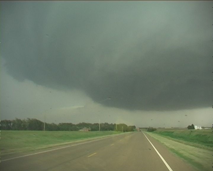
I will never forget the sight as we headed south into Comanche County! Towering cumulus developed so incredibly rapidly to our southeast. It was at that time I paused for a moment and thought of the young German couple who I had met a little earlier in the day who were on a month long bicycle adventure. We chatted briefly and they talked up the glorious weather. But this is the middle of May and we're in Kansas - if you were to consider yourself a fair weather buff, things were about to go downhill for you and fast. As we turned east onto US160, these cumulus had already rapidly organised into supercells, one now almost directly overhead. Less than an hour later, another cyclic supercell would produce a series of beautiful tornadoes during its 6 hour life-span. We were afforded five, or possibly more, blissful hours of storm chasing thanks to this storm -- but who's counting!
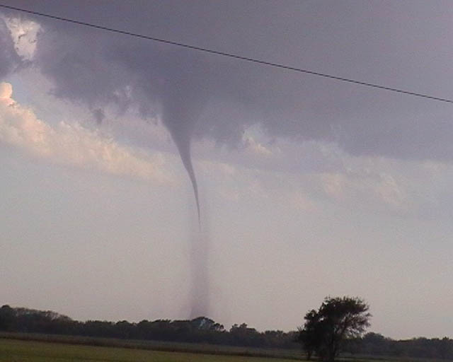
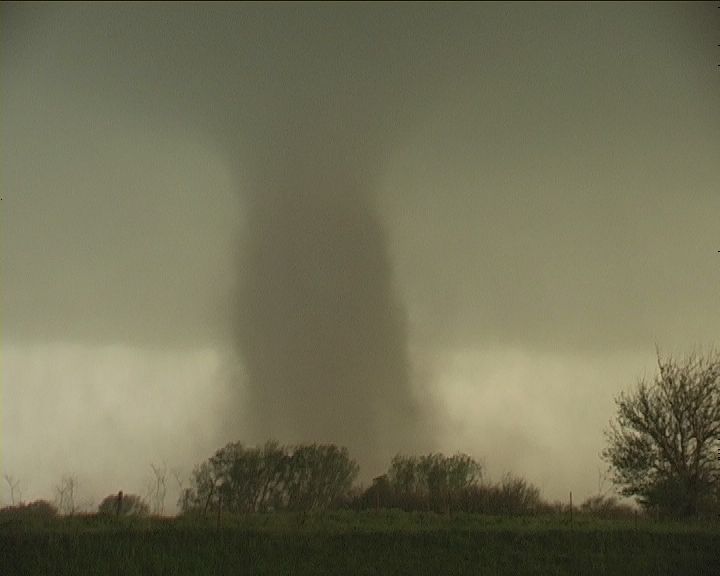
 On route east we had no choice but to punch under the updraft base of the initial storm. We encountered some hail, from the vault, as we emerged on the eastern flank; luckily only a little larger than golf ball in size! It was after all only early days. We stopped just far enough east to avoid being in the hail. New convection had exploded just to our south. The storm above us slowly maintained a northeast track which did not appeal to us, and so tail-end charlie it was. We heard tornado warnings go out for the northern cell as we headed east and away form it. It wasn't long after that a clear slot cut in to base, just to our south, and a slender funnel cloud protruded more than halfway to the ground. I heard several shrieks of delight, including one from two metres away that sounded more like a boom of thunder - it was Jimmy's verification of a tornado as dustwhirls confirmed that a tornado was on the ground near the town of Sharon. At this time, the supercell was relatively high-based though, nonetheless, beautifully organised. As the storm tracked slowly east during the evening, two conditions would become increasingly favorable for stronger tornadoes - (i) an intensifying low-level jet and (ii) richer boundary layer moisture. At ground level this was evident with each progressive mesocyclone occlusion - upon which the updraft base would lower more ominously, storm-scale rotation increased visibly and, in response, the parent mesocyclone grew to gargantuan proportions. The storm morphed from dry classic to textbook classic supercell. Tornadoes went from weak, such as the tornado pictured above, to the near stationary, violent F4 Harper tornado around 9:00pm.
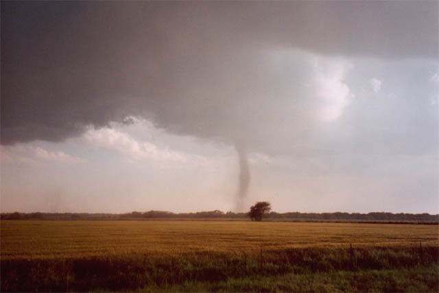
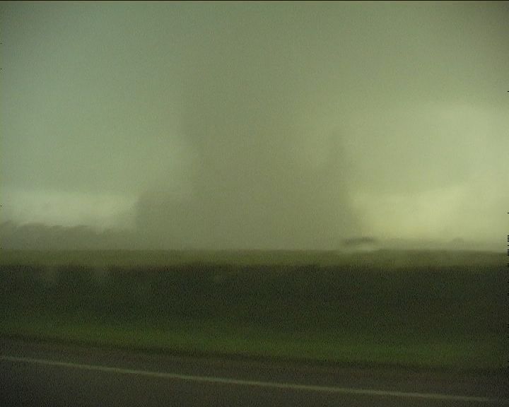
 Some 20 km further east, the second low-level mesocyclone spawns a beautiful cone-shaped dusty twister that was to be labeled the Attica tornado. The tornado initially tracked east and, during the mesocyclone occlusion, arced on a progressively more northerly track. This resulted in the tornado making a bee-line toward the town of Attica. The striated supercell structure and intensity of rotation above was simply awe-inspiring. The tornado crossed US160 less than a mile to our west. We witnessed a roof being lifted, virtually in tact, off of a house that was nearing the completion of its construction - a sobering reminder that despite ther beauty, tornadoes do destroy people's lives. Were the tornado to begin its northerly track a mere 1.5 km further west, then Attica would have suffered a direct hit and the consequences may have been deadly.
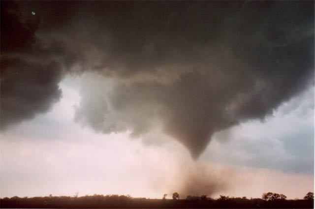
We were transfixed by the tornado as it roped out and, being aware that another low-level mesocyclone had developed to out south east, spent far too much time with it. It really was a sublime experience, interrupted only by the impact of the occasional 4-inch hailstone on the road. It was when only dust remained, that our awareness tuned back into reality! At this point it became more frantic and we raced east. As we did, another dusty tornado, quite weak and brief, developed to our south some few hundred yards away. The reason for our mild panic is best illustrated by the image ...
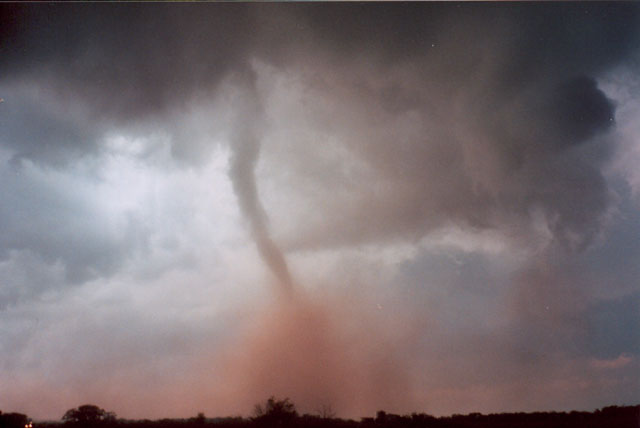
 ... a wildly striated, rapidly spinning meso had developed - the storm was, quite frankly, looking nasty at this point. To the left was a massive hail core, with which we wanted no business at all. Smooth channel CG lightning bolts were dropping randomly and ferociously out of the precipitous vault, each followed by a blast of thunder. Rapid rotation was beginning to wrap precipitation around the backside of the meso very quickly, putting us at considerable risk of being engulfed by the RFD. Another brief weak tornado agitated the ground a little over a field span to our south. We blasted east.
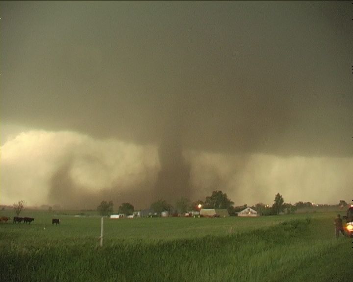
Near the town of Anthony we felt we had once again regained some sort of control, though it was short lived. We watched as another rapidly developing funnel cloud appeared to our west. The tornado quickly grew to a wide dusty stovepipe.
 Our east road option was closed. Do we head north and risk having our chase terminated by a barrage of giant hail or do we race south and attempt to cross in front of the tornado. We choose the latter. It seemed like a fairly easy maneuver, however, as we did, I began to seriously question our judgment - it appeared as though the tornado has accelerated to a position that was really very close. The RFD was incredibly strong at the time making driving to avoid a quite large tornado particularly dangerous.
 Could we have gotten it that wrong? As it turned out, this tornado was basically being slung around the meso during the occlusion and then tracked north - as per Attica less than an hour earlier.
After a somewhat disconcerting close encounter, we were finally south-east of the tornado and safe. The vista - high contrast, cows and a tornado. Gate to gate shear was around 100 knots at the time. It was dark now and we decided to call off the chase, and headed south to Enid with an encore of anvil zits.
See Jimmy Deguara's report here!
|
Document: 200405-04.html
Updated: 24th August, 2005 |
[Australian Severe Weather index] [Copyright Notice] [Email Contacts] [Search This Site] |