and Chasing
[Index][Archives]
Radar Images of the Supercell on 28th October 1995
| Storm News and Chasing [Index][Archives] |
Radar Images of the Supercell on 28th October 1995 |
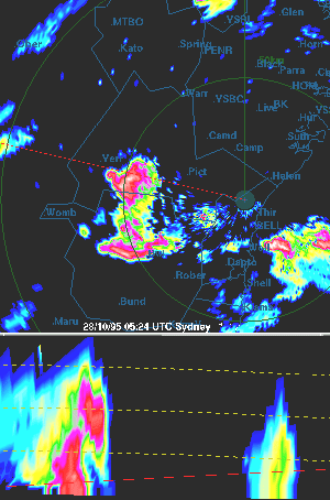
The top image of the pair is a plan (map) view whilst the bottom image is simulated height cross-section along the radial shown by the red line on the plan view. The left-hand side of the simulated cross-section is closest to the radar.
Note the pendant which is evident on the rear northern flank of the uppermost cell. This takes on a hook shape at 0610 UTC. The hook or pendant implies the storm contains a mesocyclone and forms where precipitation from the storm's rear-flank downdraft wraps around the mesocyclone (rotating clockwise, cyclonic in the southern hemisphere). The RHI scan illustrates a Bounded Weak Echo Region on the northern storm flank (notably at 0610 UTC) where the updraft rises strongly into the storm.
|
Document: 9803-03.htm
Updated: 14th January, 2003 |
[Australian Severe Weather index] [Copyright Notice] [Email Contacts] [Search This Site] |