and Chasing
[Index][Archives]
Intense rain event at Bonython, Canberra: Tuesday 5th March 1996
by Gavin O'Brien, Southside Weather Watch
| Storm News and Chasing [Index][Archives] |
Intense rain event at Bonython, Canberra: Tuesday 5th March 1996 by Gavin O'Brien, Southside Weather Watch |
The thunderstorm developed just north of Kambah about 2:45 p.m. summertime and slowly developed a curtain of rain extending towards the Tuggeranong Town Centre. I became interested by the intense cloud to ground strokes, a feature of the storms early development, and started a log.
At 3:18 a microburst developed on the northern edge of the rain which earlier was falling vertically and clearly defined. The rain started to be blown along the ground in a northerly direction and then curled up in a vortex some distance to the north towards the town centre. Our observer at Bonython remarked that the plants and flowers were flattened as though they had been trodden on. The Gordon observer also remarked that they were hit by a brief squall lasting 30 seconds to a minute, which I estimated at 60 - 70 km/h based on his description, from a NNE quadrant. Our anemometer at Gilmore recorded a peak gust of 28 km/h the ENE at 3:10 p.m., but most of the period winds were light E/NNW less than 5 km/h. By 3:37 the storm had eased to a light rain area near Thawra with brief showers extending to the northeast, east and southeast. Brief but intense lightning and thundershowers affected Chisholm and Gilmore, with a number of close lightning strokes to ground on nearby hills, including one on the summit of Gilmore Hill about 50 metres behind us. This left a very strong smell of ozone and briefly cut electricity here.
The activity eased in our area by about 4 p.m. although cumulonimbus tops were noted in all quadrants at 7 p.m. observation time.
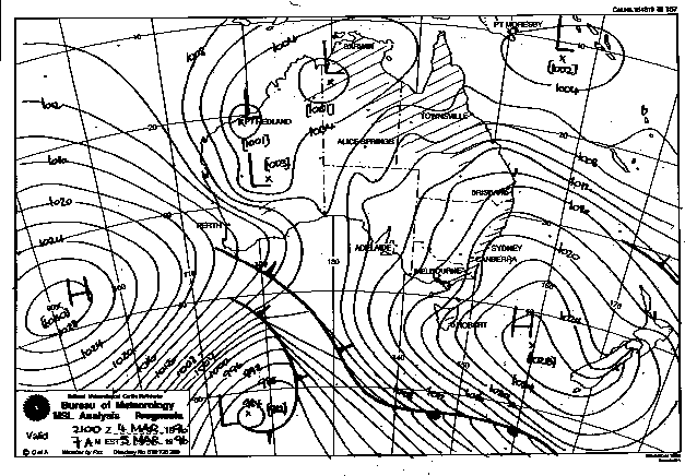
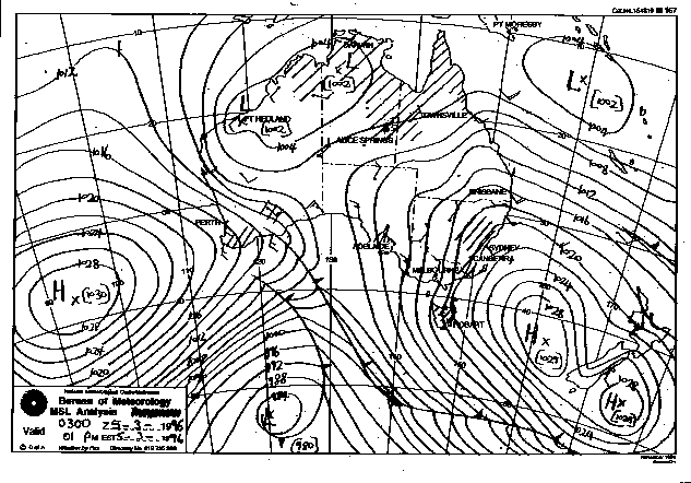
Synoptic Charts provided by the Bureau of Meteorology
|
Document: 9603-01.htm
Updated: 6th April, 2004 |
[Australian Severe Weather index] [Copyright Notice] [Email Contacts] [Search This Site] |