Author Topic: SA / VIC / NSW / QLD Storms: 26-29 November 2008  (Read 58579 times)

0 Members and 1 Guest are viewing this topic.

Offline Harley Pearman

  • Barrel tornado F4
  • *
  • Posts: 584
Re: SA / VIC / NSW / QLD Storms: 26-29 November 2008
« Reply #45 on: 30 November 2008, 12:56:51 AM »
Tamworth storm / rain event

I have not been following it too well but it appears that there has been a serious rain event around Tamworth (NW slopes of New South Wales). When looking at rainfall figures by 6 am, some rather large rainfall totals stand out. Its limited to the Tamworth region being:-

Weabonga 169 mm
Tamworth 164 mm
Goonoo Goonoo 134 mm
Duri (On Dungowan Road) 121 mm
Glendower Mountain 123 mm.
Tia 108 mm
Ogunbil 98 mm
Keeva 92 mm
Mullo Crossing 90 mm
Nowendoc 83 mm

Even Gunnedah managed 54 mm. I don't often see these rainfall totals occurring in inland NSW. Late last night around 9 pm, I briefly spied some large thunderstorm cells developing close to this region. It appears soon after, one passed over this region dumping a large amount amount of rainfall in a relatively small area.

Harley Pearman

Offline vrondes

  • Multi-vortex F1
  • *
  • Posts: 77
Re: SA / VIC / NSW / QLD Storms: 26-29 November 2008
« Reply #46 on: 30 November 2008, 02:22:46 AM »
Yes Richary , extracting some structure from yesterday's 80 kph storms was difficult, the first photo shows there was some turbulence
in the atmosphere, and the second is a cloud to cloud flash from the thundery rumble that passed through Parramatta around 5.30pm.
Harley, my Mom in Tamworth said she had never seen rain like yesterday's two storms dumped on Tamworth in such a short period
in the 40 years she's been there, possible 6 metre flood height on the Peel River this afternoon, Cheers, Con.


Offline Shaun Galman

  • Stove pipe F3
  • *
  • Posts: 441
  • Gender: Male
    • ridgelightning.com
Re: SA / VIC / NSW / QLD Storms: 26-29 November 2008
« Reply #47 on: 30 November 2008, 08:31:16 AM »
Upper Western NSW Storm Report & Photos 28th Nov. 2008

Hi guys,
Well it was certainly an interesting evenings photography yesterday. Russ and I went out just after my last post at 7:15pm as the massive anvil was already covering 98% of the sky and had mamatus everywhere. We set up down town at an area with a decent westerly view, ready for the show. There were three large embedded storms under the anvil! One large storm to our South, was hitting Walgett at the time. The second large storm was wreaking havoc up to our North near Hebel, the third (but only about half the size of the others) was coming towards us from the West (roughly). These were highly active and it made choosing a direction to photograph them from very difficult! But I didn't mind that issue at all :D


Russ (right) and myself(left) waiting for the storms to arrive. You can see the large storm to the South hitting Walgett. This had unreal crawlers everywhere, as did the one to the North also.


This was the storm that was approaching town from the West. You can see a nice split starting to happen- directly West. This would be the key to keeping us dry for what was about to happen!


A little bonus while waiting for things to get more interesting :) Lightning was constant with hardly a break in any direction (as was indicated by the LT at the time)


We headed for a nice little shelter on the NW side of town as the split gained momentum and this nice little base formed right in front of us. No colour adjustments in any of these photos.


My very first sunset CG photograph!!! This little base on the rear edge of the large storm to the North really paid off! I would have thought that even if there were 5 or 6 of us photographing at this point many crawlers and CG would have still gone amiss due to the widespread nature of the system!


I was so happy with the result of this small cell! It's how we'd like all cells I guess? No rain and more lightning than you could poke a lightning rod at lol.

TBC.
Chasing Region: Lightning Ridge. N.S.W.
Website: www.ridgelightning.com

Offline Shaun Galman

  • Stove pipe F3
  • *
  • Posts: 441
  • Gender: Male
    • ridgelightning.com
Re: SA / VIC / NSW / QLD Storms: 26-29 November 2008
« Reply #48 on: 30 November 2008, 08:51:44 AM »
Upper Western NSW Storm Report & Photos 28th Nov. 2008
Continued...


I have this cell in it's entirety so the timelapse may be worth the effort? There seemed to be a great microburst near the time we had to leave due to the heavy rain that resulted as this cell built. The inflow winds were very warm driving back into the storm! Felt like the temps were still around 28Âșc at this point around 8pm.


This is the start of the microburst/heavy rain which came down through 8 or 9 consectutive photos. I haven't seen a sunset lit storm here like this in 5yrs of photographing storms! I remember thinking to myself (and mentioning to Russ on more than one occasion) "WOW! those colours are unreal!"
We headed for cover just after this as we couldn't escape the heavy rain coming from all directions.


This is the back edge of the large storm to our North. You can just see the nice crisp anvil edge that was above us, again mamatus was everywhere! The cells out on the tree line here (which had plenty of lightning at this point) came over town at 11:30pm and dumped further rain and put on a semi-decent show of crawlers.


This is facing just to the right of the photo above and shows the active part of this large storm. This is looking generally NW from town.


We wrapped things up after this (8:49pm) as the storms grew just too distant and the mozzies were driving us nuts!

Definitely an amazing storm outcome! I still would like to know why storms seem to split around us so frequently? It happens more often than can be considered coincidence. I just wonder whether the ridges to our west have an effect on the winds even though they are only under 100feet from the ground level of the surrounding plains? Just a thought.

Kindest regards,
Shauno   
Chasing Region: Lightning Ridge. N.S.W.
Website: www.ridgelightning.com

Offline Ursula

  • Multi-vortex F1
  • *
  • Posts: 33
  • Gender: Female
Re: SA / VIC / NSW / QLD Storms: 26-29 November 2008
« Reply #49 on: 30 November 2008, 10:10:03 AM »
I have small hail and heavy rain at 3.50 pm heading towards Batemanns Bay and Braidwood the cell split, it had rotation,

better get off it is starting again

Ursula

Offline Kristy Norman

  • Elephant Trunk F2
  • *
  • Posts: 120
  • Gender: Female
Re: SA / VIC / NSW / QLD Storms: 26-29 November 2008
« Reply #50 on: 30 November 2008, 10:41:07 AM »
I didn't think today would have too much to offer us down here in the way of thunderstorms, how wrong I was!! There is a cell to the north of us and I've heard a few distant rumbles, and more appear to be developing to south and east.

Offline Richary

  • Barrel tornado F4
  • *
  • Posts: 680
  • Gender: Male
Re: SA / VIC / NSW / QLD Storms: 26-29 November 2008
« Reply #51 on: 30 November 2008, 01:03:25 PM »
Sitting here in the middle of a severe warned storm at Rydalmere. Lots of lightning in the sky before, and hail to golf ball size is hitting the ground now. Together with torrential rain.

Glad I saw the warning and got the cars undercover!

Offline Dave Nelson

  • Elephant Trunk F2
  • *
  • Posts: 172
  • Gender: Male
    • Stormy Sydney
Re: SA / VIC / NSW / QLD Storms: 26-29 November 2008
« Reply #52 on: 30 November 2008, 01:28:10 PM »
Sitting here in the middle of a severe warned storm at Rydalmere. Lots of lightning in the sky before, and hail to golf ball size is hitting the ground now. Together with torrential rain.

Glad I saw the warning and got the cars undercover!

yup  a good fast moving cell over head west ryde to paramatta.   hail to 1.5 cm here in west ryde
saw many good CG's a lot of other lightning within the clouds.   lightning tracker shows that the lightning peaked
just prior to arrival here  and died off pretty quickly as the storm headed towards the nthrn beaches

Dave N

Offline Richary

  • Barrel tornado F4
  • *
  • Posts: 680
  • Gender: Male
Re: SA / VIC / NSW / QLD Storms: 26-29 November 2008
« Reply #53 on: 30 November 2008, 02:27:42 PM »
The second line of storms that hit here about 8 seemed to come out of nowhere. Just a line forming between Parramatta and Warragamba, not moving that much and brought another 5mm in fairly quick time. It then stopped but now we have a few more flashes and light rain. I had thought about going camping tonight, in hindsight staying home might have been a wise decision.

Didn't get any spectacular lightning photos or anything, but will post some of the hail a bit later.

I also went for a stroll down the street after the first storm with the hail had passed, no damage to any vehicles here but still I would have been a bit nervous if the car had been in the driveway while it was happening. They certainly sound loud enough on the tin roof at this place! Also we didn't really get the wind that the severe storm warning mentioned, though the hail was landing on a fair angle from the SW. Had a bit of outflow pushing the rain at it's heaviest but nothing major.

Offline David Brodrick

  • Elephant Trunk F2
  • *
  • Posts: 130
    • Oz Forecast
Re: SA / VIC / NSW / QLD Storms: 26-29 November 2008
« Reply #54 on: 30 November 2008, 02:51:35 PM »
Tamworth Flooding

In addition to Harley's post above, the two manual stations near Gunnedah each recorded about 110mm. The water is currently below minor in Gunnedah and looks like it will soon peak. Peak expected Monday/Tuesday in Narrabri and moderate flooding in Wee Waa late Tuesday.

A flood warning has been issued:

Predicted River Heights/Flows:
Manilla
Peak near 6.3 metres early Sunday morning, 30/11/2008 with Minor flooding
Gunnedah
Reach Minor Flood level [7.3 metres] around 9:00pm Tonight, Saturday 29/11/2008
Peak near 7.8 metres noon Sunday 30/11/2008 with Moderate Flooding
Wee Waa
Reach Moderate Flood level [6.4 metres] Tuesday afternoon 2/12/2008


My mate Brett sent these photos of the Peel through the Tamworth CBD in flood. Tamworth was effectively cut in two as one bridge was under water (pictured) and the roads approaching the big bridge were flooded. The SES has been busy and there were the usual car accidents and silly twits getting their cars stuck in flooded causeways.


« Last Edit: 11 December 2008, 04:51:28 PM by Jimmy Deguara »

Offline Harley Pearman

  • Barrel tornado F4
  • *
  • Posts: 584
Re: SA / VIC / NSW / QLD Storms: 26-29 November 2008
« Reply #55 on: 30 November 2008, 03:05:01 PM »
I don't remember seeing thunderstorms in the forecast for Sydney. Just got back indoors after doing some photography.

At around 7 pm a short but very intense thunderstorm passed over Blacktown and headed NE. I just had enough time to find a spot near the Blacktown Hospital to take some photographs before it hit.

I had hail to about 2 cm but it was brief followed by torrential rain for a few minutes before easing. Clouds were very photogenic after the event. Some good photos too but still in the camera.

Another two cells passed overhead after sunset both dropping short but sharp showers and occasional lightning but they did not match the intensity of the first one.

Harley Pearman

Offline Richary

  • Barrel tornado F4
  • *
  • Posts: 680
  • Gender: Male
Re: SA / VIC / NSW / QLD Storms: 26-29 November 2008
« Reply #56 on: 30 November 2008, 04:42:03 PM »
Harley - I didn't see any storm forecasts either for tonight, though 9 news mentioned the chance of them tonight (only a couple of minutes before the severe storm warning was issued).

Nothing spectacular here in the way of pics, the first was the storm clouds gathering to my west before it hit, the 2nd during the heaviest part of the hail/downpour, and the last taken as I was heading up the road to get some takeaway, a nice backlit shot that was probably a different cell. Only had the phone to photo that last one though.

Hail initially started here at about marble size, and slowly grew to a mix ranging from marble sized round ones to probably 2-2.5cm slightly flattened pieces. Towards the end apart from the big ones we also had pea size. And lots of rain very quickly.

Just had another rain band go over, but no lightning associated with this one.


Offline Michael Bath

  • storm chaser
  • Administrator
  • Wedge tornado F5
  • *
  • Posts: 1,602
  • Gender: Male
    • Australian Severe Weather
Re: SA / VIC / NSW / QLD Storms: 26-29 November 2008
« Reply #57 on: 01 December 2008, 04:33:47 AM »
Beautiful photographs Shauno - I love lightning at sunset - about as good as it gets :)  Those are the special events for photography that you remember for a lifetime.

Thanks also to everyone for the reporting on the Tamworth region floods. Obs show some significant rain from storms late Thursday (the 34mm to 9am 28th) followed by some impressive morning storm totals (79mm), then flash flooding (over 70mm in 1 hour) and subsequent river flooding in the evening.

And then Sydney cops a hailstorm to end this weather event - awesome !

Michael
Location: Mcleans Ridges, NSW Northern Rivers
Australian Severe Weather:   http://australiasevereweather.com/
Lightning Photography:   http://www.lightningphotography.com/
Early Warning Network: http://www.ewn.com.au
Contact: Michael Bath

Offline Shaun Galman

  • Stove pipe F3
  • *
  • Posts: 441
  • Gender: Male
    • ridgelightning.com
Re: SA / VIC / NSW / QLD Storms: 26-29 November 2008
« Reply #58 on: 01 December 2008, 04:50:55 AM »
Beautiful photographs Shauno - I love lightning at sunset - about as good as it gets :)  Those are the special events for photography that you remember for a lifetime.

Michael

Cheers very much Michael :D
I will remember it for a long time to come, no doubt about that! I think sunset lit storms have always been my favorite kind and I'm always awe struck whenever I see photos of that nature posted here by members! I hope I did it the justice it deserved :)

I should add also that we received 10mm of rain in total for the 28th. Also we had a brief amount of smallish 3-4mm sized hail from that cell.

I was surprised by the flooding at Tamworth. I hope damage was kept to a minimum.
Take care,
Shauno
Chasing Region: Lightning Ridge. N.S.W.
Website: www.ridgelightning.com

Offline vrondes

  • Multi-vortex F1
  • *
  • Posts: 77
Re: SA / VIC / NSW / QLD Storms: 26-29 November 2008
« Reply #59 on: 01 December 2008, 06:05:04 AM »
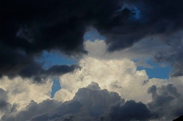
Well a day cleaning the home , yesterday Saturday the 29th of November, had the bonus of some nice convection throughout the afternoon before we had to head to the city in the evening. Then around 6.30pm a vocal sky courtesy of rumblings to the south west prompted a delay in leaving so I could grab some photos of the severe storm heading our way. 1st photo is of the turbulent sky to the east,


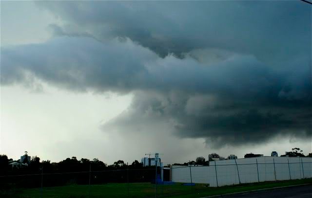
This is taken around 6.45pm as it was coming to Parramatta, inflow stingers and a possible tail cloud in the bottom left and rear were some nice structures with the storm, quite lightning active before I managed to find  a clear vantage point to photograph,


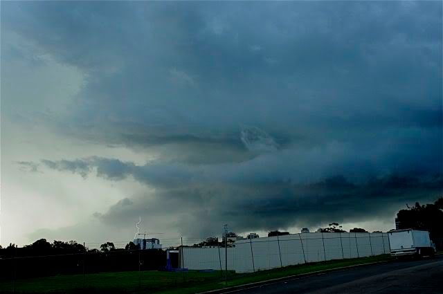
south easterly low level infeed certainly gave it some nice dynamics,


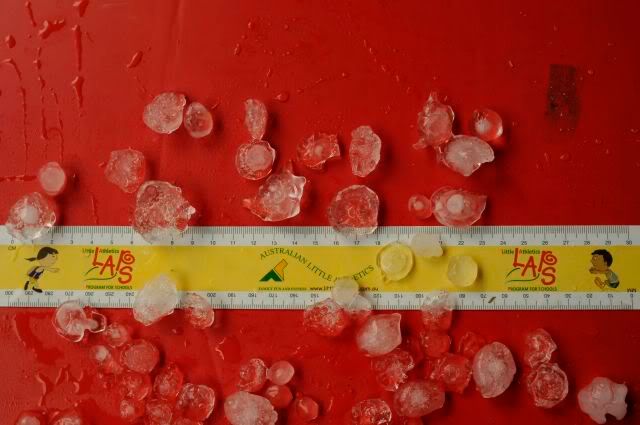
Hail from 6.45 at home was from 1 to 2.5 cms with the odd 3cm stone, they were mostly pancake in shape as mentioned by Richary and clear crystalline in appearance with the odd round opaque one, this lasted for 10 mins then the downburst turned the home into a tamworth type floodplain, and by the way , excellent photos by Brett of the hometown in flood, 1984 being the last time I've seen the waters breach the banks to that extent,


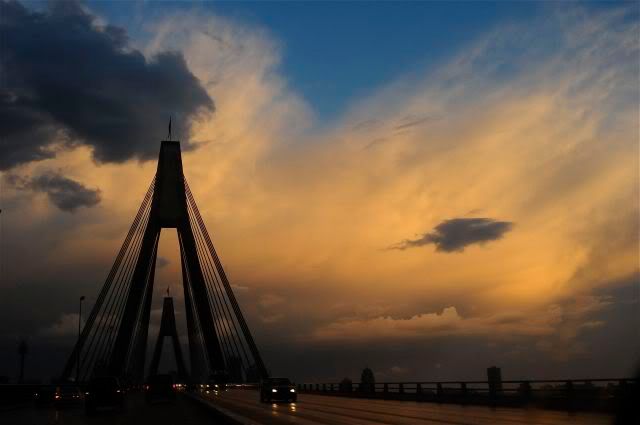
and finally the storm's anvil as a backdrop on our trip into town, Cheers, Con.