Did anyone have a look at the setup over parts of Central Australia today ? There's been severe thunderstorm warnings out for parts of northern SA, southern NT and NW NSW as a result.
That's a pretty special sounding from Giles.
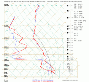
Giles
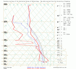
Alice Springs
By Harald Richter, BoM
23z/17 Giles sounding is scary: deep moisture that will not mix out sits underneath
a cap that is stout but breakable, with a dry adiabat above it promising buoyancy nirvana
once initiation has decided to take place. A broad subtropical jet sits over the entire area
providing adequate deep layer shear for supercells. It gets better: given a rotating storm
near that warm frontal?? boundary that I am hallucinating about in the very sparse
surface data N and W of Coober Pedy (northerlies backing to ENE-lies), whatever/whoever
lives in the general area might just get treated to something very special with
rotation near ground level ...
IDD20430
Australian Government Bureau of Meteorology
Northern Territory
TOP PRIORITY FOR IMMEDIATE BROADCAST
SEVERE THUNDERSTORM WARNING
for Damaging Winds, Large Hailstones and Very Heavy Rainfall
For people in Alice Springs
Issued at 7:46 pm on Tuesday 18 November 2008
Thunderstorms with potential for damaging winds, large hailstones and very heavy rainfall have been observed on radar and are expected to affect Alice Springs between 2040 pm and 2240 pm CST.
The Northern Territory Emergency Service advises that people should secure loose outside objects, move cars under cover and seek shelter. Driving conditions may be hazardous - avoid flooded roads and watercourses.
Issued at 7:46 pm on Tuesday 18 November 2008


