Author Topic: NSW, VIC and SE QLD Storms (incl Brisbane severe storm): 12-16 Nov 2008  (Read 93387 times)

0 Members and 2 Guests are viewing this topic.

Jeff Brislane

  • Guest
Re: NSW, VIC and SE QLD Storms (incl Brisbane severe storm): 12-16 Nov 2008
« Reply #45 on: 17 November 2008, 01:42:49 PM »
Wow, the size of that cell was/is enormous! I can just imagine the massive striated shelf cloud it must have had as it interacted with moisture from the ocean. I can't wait to see photos of this beast!

Jeff Brislane

  • Guest
Re: NSW, VIC and SE QLD Storms (incl Brisbane severe storm): 12-16 Nov 2008
« Reply #46 on: 17 November 2008, 02:06:36 PM »
I've seen an interesting image of todays storm in se qld. If it's looking south than it appears to have a nice wet RFD to the right with the notch/inflow area in the middle. Hard to tell though without being there.

http://s60.photobucket.com/albums/h15/frontera264/?action=view&current=IMGP4925.jpg

Offline Michael Bath

  • storm chaser
  • Administrator
  • Wedge tornado F5
  • *
  • Posts: 1,602
  • Gender: Male
    • Australian Severe Weather
Re: NSW, VIC and SE QLD Storms (incl Brisbane severe storm): 12-16 Nov 2008
« Reply #47 on: 17 November 2008, 02:15:37 PM »
I chased from Lismore - Kyogle - then over the border using the Lions Road to Rathdowny and Beaudesert - some awesome structure - will post pics very soon :)
Location: Mcleans Ridges, NSW Northern Rivers
Australian Severe Weather:   http://australiasevereweather.com/
Lightning Photography:   http://www.lightningphotography.com/
Early Warning Network: http://www.ewn.com.au
Contact: Michael Bath

Offline Michael Bath

  • storm chaser
  • Administrator
  • Wedge tornado F5
  • *
  • Posts: 1,602
  • Gender: Male
    • Australian Severe Weather
Re: NSW, VIC and SE QLD Storms (incl Brisbane severe storm): 12-16 Nov 2008
« Reply #48 on: 17 November 2008, 02:51:47 PM »
Storms kicked off fairly early and quite quickly in the Northern Rivers. I chased out to south of Kyogle at first. The cell in the first photo, although not particularly photogenic was very lightning active with many clear-air CGs. The storm to the right in the background was the early stages of the main one that crossed the border. Photo times are EDT.

---> all photos for 16 November 2008


12.16pm

I headed up the Lions Road north of Wiangaree. There are not many views along this drive apart from the Border Loop lookout a couple of ks south of the Queensland border. This is where the next pics were taken. A massive rain free base formed then a wall cloud - all the while bright white CGs punched into the valley and hills around the view.
 
1.42pm

1.48pm

1.52pm

I left there at the last moment, then crossed into Queensland and headed for Rathdowney. The storm had lost some of its features at this point and was very much outflow dominant. New bases were forming to the north. I drove towards Beaudesert buffeted by very strong winds. The first part of this drive has lots of trees and some branches were thrown across the road. I soon made it to a clearing near Laravale I think where the structure was once again very impressive.

2.58pm

3.01pm

I was tempted to drive into the core towards Canungra but not being in my using hail dented car I declined this time!

Instead I moved to just north of Beaudesert and watched the flanking line and powerful new updrafts at the back.

3.21pm

3.33pm

3.40pm

I met up with Chrissy nearby then decided to head home. Heavy rain fell during the drive to Rathdowney with some powerful pulsating CGs too.


« Last Edit: 23 November 2008, 05:41:02 AM by Michael Bath »
Location: Mcleans Ridges, NSW Northern Rivers
Australian Severe Weather:   http://australiasevereweather.com/
Lightning Photography:   http://www.lightningphotography.com/
Early Warning Network: http://www.ewn.com.au
Contact: Michael Bath

Offline Jimmy Deguara

  • Australian and Tornado Alley storm chaser
  • Administrator
  • Wedge tornado F5
  • *
  • Posts: 2,218
  • Gender: Male
  • Storm Chaser since 1993, Tornado Alley 2001
    • Australia Severe Weather
Re: NSW, VIC and SE QLD Storms (incl Brisbane severe storm): 12-16 Nov 2008
« Reply #49 on: 18 November 2008, 01:17:21 AM »
Hi guys,

Perhaps we can get people to add to this thread some storm and hail videos from November 16 Brisbane storms with a description including some locality and time if available.

Redbank Plains:
http://au.youtube.com/watch?v=_tkFfJGN2dA

Collingwood Park:
http://au.youtube.com/watch?v=xfsrsfleYCA

Jimmy


MB edit - added another clip and locations.

« Last Edit: 18 November 2008, 02:47:46 AM by Michael Bath »
-------------------------------------
Australian Severe Weather
www.australiasevereweather.com

Australian Thunderbolt Tours
www.thunderbolttours.com

Phone  0408 020468  (International :  61  2  408 020468)

Offline Michael Bath

  • storm chaser
  • Administrator
  • Wedge tornado F5
  • *
  • Posts: 1,602
  • Gender: Male
    • Australian Severe Weather
Re: NSW, VIC and SE QLD Storms (incl Brisbane severe storm): 12-16 Nov 2008
« Reply #50 on: 18 November 2008, 03:33:54 AM »
Some weather data for yesterday. There is evidence that a tornado occurred in the Tamborine area (Gold Coast hinterland) - probably about the time of this radar image:

---> Brisbane radar loop


---> VIS satpic loop


Location: Mcleans Ridges, NSW Northern Rivers
Australian Severe Weather:   http://australiasevereweather.com/
Lightning Photography:   http://www.lightningphotography.com/
Early Warning Network: http://www.ewn.com.au
Contact: Michael Bath

Offline Richary

  • Barrel tornado F4
  • *
  • Posts: 680
  • Gender: Male
Re: NSW, VIC and SE QLD Storms (incl Brisbane severe storm): 12-16 Nov 2008
« Reply #51 on: 18 November 2008, 03:58:04 AM »
Stories and pictures at

http://www.news.com.au/couriermail/story/0,23739,24659338-952,00.html

In yesterday's storm tragedy, police said the 19-year-old victim and a 20-year-old friend were taking photographs in a drain behind the Westfield Chermside shopping centre when they were overwhelmed by flash flooding.

Seems like a silly place to be taking photos of a storm from.

Offline David C

  • Global Moderator
  • Barrel tornado F4
  • *
  • Posts: 643
  • Gender: Male
    • Thunderbolt Tours Storm Chasing Adventures
Re: NSW, VIC and SE QLD Storms (incl Brisbane severe storm): 12-16 Nov 2008
« Reply #52 on: 18 November 2008, 05:15:07 AM »
Supercell David ?  there has not been any warnings this arvo - though that is surprising given some of the radar returns.


Hi Michael.
 
http://radar.strikeone.net.au/?fuseaction=loops.main&radar=403&numberofImages=10&dateStart=1226624400&dateFinish=1226642400

The storm developed east of Collector around 3:30UTC
I posted after looking at the 4:50 UTC frame and following the split 4:20 UTC.

Looking at this loop, I would be confident that a storm split occurred rather than a completely new updraft developing, and then the dominant storm propagates somewhat to the left of the mean 500-700 flow. After my post, the storm never quite got going to the extent that I envisaged at the time, in fact I thought it might head more towards Nowra from around 4:30UTC on.

Nevertheless, from our previous discussions that we have had on here, in strong shear a vortex couplet develops in response to the tilting of horizontal vorticity into the vertical. When the near storm environment is characterised by a straight line hodograph, the vertical pressure perturbation gradient results in renewed development to the north of the cyclonic vortex and to the south of the anticyclonic vortex. The pressure perturbation gradient also induces a downdraft between the two, which accentuates the splitting and leads to the development of two separate updrafts. From that point on, the updraft can continue to intensify and reach mesocyclone status, the rapidity of which depends depends on the environment that the storm propagates into. Cant be sure that this storm ever reached those criteria, however she gave it a pretty good shot, as per Pingtangs post.

http://twister.ou.edu/MM2005/Klemp87Review.pdf


Storm Chaser,
Thunderbolt Tours - USA & Australia Storm Chase Tours
www.thunderbolttours.com

Jeff Brislane

  • Guest
Re: NSW, VIC and SE QLD Storms (incl Brisbane severe storm): 12-16 Nov 2008
« Reply #53 on: 18 November 2008, 05:47:54 AM »
Hi Everyone,

Just quickly I wanted to point out this radar scan from the 15th, just south of Grafton. The cell in question starts just north of Dorrigo and moves sharply left before dissipating rapidly near the coast. I know it's not exactly a huge cell but the shape on radar is amazing with possibly a very well defined hook and miniature flying eagle signature. Awesome!

Note also the sharp right mover come from Grafton just after it. What a great area for supercells.


---> Grafton radar loop


Regards Jeff.
« Last Edit: 18 November 2008, 06:16:47 AM by Michael Bath »

Offline Michael Bath

  • storm chaser
  • Administrator
  • Wedge tornado F5
  • *
  • Posts: 1,602
  • Gender: Male
    • Australian Severe Weather
Re: NSW, VIC and SE QLD Storms (incl Brisbane severe storm): 12-16 Nov 2008
« Reply #54 on: 18 November 2008, 06:27:38 AM »
Hi Jeff - saw the last part of that cell from Whiporie and it had a small LP like appearance with what looked like an inflow band but I only have a low contrast wide angle pic of the scene at 3pm which was dominated by altocumulus on the N-NW side of the storm.
Location: Mcleans Ridges, NSW Northern Rivers
Australian Severe Weather:   http://australiasevereweather.com/
Lightning Photography:   http://www.lightningphotography.com/
Early Warning Network: http://www.ewn.com.au
Contact: Michael Bath

Offline vrondes

  • Multi-vortex F1
  • *
  • Posts: 77
Re: NSW, VIC and SE QLD Storms (incl Brisbane severe storm): 12-16 Nov 2008
« Reply #55 on: 18 November 2008, 08:30:01 AM »
A few images from the storms that went through Sydney last Friday the 14th,
 
1st one is from an isolated thundery shower before the main line hit,


The following is from the outflow of the main storm as it mopped up the smoke from the northern suburbs bushfire burnoff,


and the last is a radial anvil crawler as the storm  headed off to the central coast,
Again, wonderful photos and reports from the wekends events,Cheers, Con


Offline Jason(pato)

  • Elephant Trunk F2
  • *
  • Posts: 136
  • Gender: Male
Re: NSW, VIC and SE QLD Storms (incl Brisbane severe storm): 12-16 Nov 2008
« Reply #56 on: 18 November 2008, 09:27:45 AM »
Gday All,

Once again great photos here. I was unable to chase yesterday unfortunately due to a prior commitment. Have been talking to my cousin on messenger who lives at Middle Park just off the Centenary Hwy in Brisbanes SW, and he was saying how incredible the structure and colour were of the storm yesterday Nov 16. He has subsequently been on a damage survey around the areas of The Gap, Keperra, and Arana Hills this is what he had to say........

...........Stuart says:
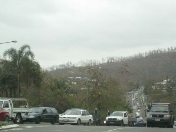
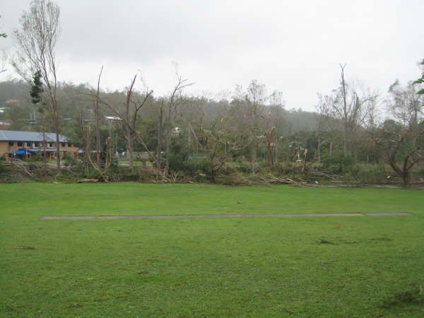
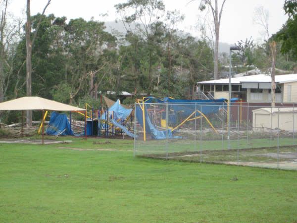
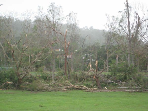
the hill going from The Gap to Keperra reminded me of Mt St Helens . The trees were laying down like match sticks. The ones that remained were stripped of bark. You can see it in the background of one of the pics. That hill is usually dense with trees now it looks kinda bare......

and this

...........Stuart says:
Haven't heard reports of wind speed in that particular area but it had to be ridiculous. Almost every thing above 5m was snapped. I saw a bunch of local cars driving where the leaves were stuck on the car whilst they were doing 60 or 70km/h. Not cos of wet but like mozzies on your windscreen. Squashed into the car.........

I think this is the hill he was referring too


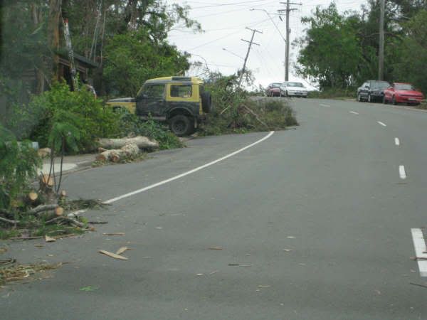
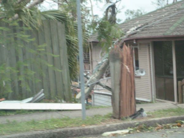
I was absolutely gobsmacked at this last photo. The winds needed to snap that pole off and toss the remains into the house behind had to be pretty substantial. Its not like it was snapped off half way up, its near the base. Anyway thought some of you would like to see these images. A big thanks to my cousin Stuart Middleton for letting me share the images with you.

Cheers Jason
South Lismore, Northern Rivers NSW.....Supercells are us!!

kaety

  • Guest
Re: NSW, VIC and SE QLD Storms (incl Brisbane severe storm): 12-16 Nov 2008
« Reply #57 on: 18 November 2008, 10:39:03 AM »
Hi All,

Amazing Photos everyone!!!


My storm report and a collection of everyone/news reports is posted here!

My Blog of the Storm http://kaety.blogspot.com/2008/11/big-blue-storm-sunday-16th-nov.html

Kaety

Offline Shaun Galman

  • Stove pipe F3
  • *
  • Posts: 441
  • Gender: Male
    • ridgelightning.com
Re: NSW, VIC and SE QLD Storms (incl Brisbane severe storm): 12-16 Nov 2008
« Reply #58 on: 18 November 2008, 12:52:57 PM »
Hi guys,

Amazing photos by all!
What a nasty little storm system that was. Those damage shots are spectacular Jason (Pato)! And I agree with you totally about seeing a power pole snapped clean off at the base! That's just nuts!

Was this strong wind outflow or something more along the tornado lines? Do you or anybody know as yet? I heard reports of a tornado on the channel7 news this morning but I didn't catch the whereabouts of it's location (if proven to be a fair dinkum sighting)

Once again SE QLD and NE NSW were the places to be chasing!

Take care,
Shauno
*some slight showers in our area today and it appeared to be creating some storm action to our NE with a nice lower level inflow band heading into the main cell earlier on around 4:45pm.

 
Chasing Region: Lightning Ridge. N.S.W.
Website: www.ridgelightning.com

Offline Harley Pearman

  • Barrel tornado F4
  • *
  • Posts: 584
Re: NSW, VIC and SE QLD Storms (incl Brisbane severe storm): 12-16 Nov 2008
« Reply #59 on: 18 November 2008, 02:05:40 PM »
Reading the Brisbane Times, I came across a large photo gallery of the aftermath at
http://www.brisbanetimes.com.au/photogallery/2008/11/17/1226770297082.html

Most of the photos show the flash flooding and trees brought down in affected areas. However what disturbs me most is one photo showing a driver in a small car attempting to cross a heavily flooded road immediately after the thunderstorm. I wonder if the driver made it across.

Indeed in these situations the most appropriate course of action is not try to cross a flooded road.

The photos shows the extensive damage done and worth a look.

Harley Pearman