Author Topic: Australian region tropical cyclone season: 2008 - 2009  (Read 17643 times)

0 Members and 1 Guest are viewing this topic.

Offline Mike

  • Australian Severe Weather Moderators
  • Wedge tornado F5
  • *
  • Posts: 1,348
  • Gender: Male
  • Dry season here...boring!
    • http://StormscapesDarwin.com
Australian region tropical cyclone season: 2008 - 2009
« on: 21 October 2008, 07:06:48 AM »
The bureau's cyclone outlooks have been posted on the BoM website outlining their expectations under the current conditions relevant to those areas.  Darwin is a little more up beat this season with the SOI and SST's in the positives which up our averages for cyclone activity in our waters.

Details of the outlook for the 2008/2009 tropical cyclone season for the Northern Region:

* An early cyclone (i.e. before Christmas) is possible this year in the Timor Sea.
* This season may produce an above average number of tropical cyclones around the Top End. In an average year, 2 to 3 cyclones form in the Northern Region. As many as 5 tropical cyclones have formed in a season since records began.
* There is an even chance of a severe tropical cyclone (Category 3 or greater) during the season.
* On average there is around one coastal impact in the Northern Territory during each season.

The 2008/2009 tropical cyclone season outlook is based on high values of the Southern Oscillation Index (SOI), near average sea surface temperatures about northern Australia and recent climate patterns in the Australian and south Pacific region. These patterns indicate a neutral El NiƱo - Southern Oscillation situation.

The Northern Region incorporates the eastern Timor Sea, Arafura Sea and the Gulf of Carpentaria.

If this is the scenario then I would expect WA to be getting a lot more than they did last season.  It's well documented that WA receives the majority of cyclones moving east -> west across the Top End.  Ones that are a smaller category here always intensify to at least on average CAT4 status.

Should be an interesting season if it's nudging neutral to el Nino.

Any members who have any thoughts on the country's cyclone outlooks given the bulletins would be welcome in this thread.
Darwin, Northern Territory.
StormscapesDarwin.com
Lightning Research 2010/14

Offline Carlos E

  • Elephant Trunk F2
  • *
  • Posts: 135
  • Gender: Male
Re: Australian region tropical cyclone season: 2008 - 2009
« Reply #1 on: 24 October 2008, 10:03:30 PM »
I expect 2 (possibly 3) Cyclones to impact directly on WA; the east coast as BoM says has a fair chance of being struck, though you have to wonder how far south this could possibly happen. NT may not get very large Cyclones, but for some reason a lot of them up there become monsters with regard to Wind Gusts.

One thing they have done with this season that I am much happier with is making the name listings for each area Universal (instead of separate lists for each warning centre). It's also better that our naming doesn't always (although it will this year) start with A and that it simply continues from where it left off from season to season.

« Last Edit: 25 October 2008, 12:08:52 AM by Jimmy Deguara »

Offline Mike

  • Australian Severe Weather Moderators
  • Wedge tornado F5
  • *
  • Posts: 1,348
  • Gender: Male
  • Dry season here...boring!
    • http://StormscapesDarwin.com
Re: Australian region tropical cyclone season: 2008 - 2009
« Reply #2 on: 25 October 2008, 03:52:09 AM »
The bureau up here has been giving the usual warnings for residents prior to the cyclone season and mentioned that our waters are a lot warmer than last season.  They also said that there is always the chance that a cyclone could form in the Timor Sea also this year as systems in that area tend to swing toward Darwin as opposed to Arafura Sea cyclones moving across us over to WA with the trade winds.  Given the outlooks it's something one has to be aware of and i don't predict what systems go where or how many, the bureau has a hard enough time forecasting their tracks and cop enough flack from the public about it (because the public are the experts remember...)

Darwin, Northern Territory.
StormscapesDarwin.com
Lightning Research 2010/14

Offline Carlos E

  • Elephant Trunk F2
  • *
  • Posts: 135
  • Gender: Male
Re: Australian region tropical cyclone season: 2008 - 2009
« Reply #3 on: 19 November 2008, 09:42:39 AM »
It appears the first Cyclone may develop in the next few days based on the latest outlook from the BoM for the south-central Indian Ocean.

TROPICAL CYCLONE OUTLOOK FOR THE CENTRAL INDIAN OCEAN
Issued at 12:17pm WDT on Tuesday the 18th of November 2008
For the area south of LATITUDE 10 SOUTH between LONGITUDES 90 - 110 EAST

A low has developed near 9S 91E within an active monsoon trough. It is expected
to develop further in the next few days and may reach cyclone intensity later on
Wednesday or Thursday as it moves to the east southeast into the region.

A second low is developing well west of the area and is also expected to move
eastwards in the next few days approaching 90E by the weekend.
 
The likelihood of a tropical cyclone occurring in the next three days is
Wednesday : High
Thursday  : High
Friday    : High
** NOTE: Development potential is an estimate of the probability of        **
** tropical cyclone development within a 24 hour period.                   **
** LOW = 10% or less  MODERATE = 20-40%   HIGH = 50% or more               **


Source: http://www.bom.gov.au/cgi-bin/wrap_fwo.pl?IDW10900.txt

Offline Peter J

  • Stove pipe F3
  • *
  • Posts: 419
  • Gender: Male
  • Lets go get em boys!
Re: Australian region tropical cyclone season: 2008 - 2009
« Reply #4 on: 19 November 2008, 07:59:27 PM »
Carlos,

I haven't been near my computer until about 10 mins ago (1:56am EDST), but I've noticed the same warning issued by the BoM - I know they have been testing some new equipment for cyclone forecasting this year, but I think we may acually have one building out near the Cocos Island area - according to Wz, the CI airport has received near 203mm in the last 18 hrs or so. Also, looking at the surface chart, it does look like some storms are starting to band together in cyclonic formation.

The BoM is forecasting a Cat 2 storm to near WA/NT coast in the next 2-3 days.

Worth watching out for.

Big Pete
(Mike of Darwin - might be worth keeping an eye on this one)
PJJ

Offline Michael Bath

  • storm chaser
  • Administrator
  • Wedge tornado F5
  • *
  • Posts: 1,602
  • Gender: Male
    • Australian Severe Weather
Re: Australian region tropical cyclone season: 2008 - 2009
« Reply #5 on: 20 November 2008, 01:55:37 AM »
Hi all - feel free to start new threads for major TCs, otherwise just use this thread.

BoM are expecting a TC to be named by this afternoon (19th Nov)

Location: Mcleans Ridges, NSW Northern Rivers
Australian Severe Weather:   http://australiasevereweather.com/
Lightning Photography:   http://www.lightningphotography.com/
Early Warning Network: http://www.ewn.com.au
Contact: Michael Bath

Offline Michael Bath

  • storm chaser
  • Administrator
  • Wedge tornado F5
  • *
  • Posts: 1,602
  • Gender: Male
    • Australian Severe Weather
Re: Australian region tropical cyclone season: 2008 - 2009
« Reply #6 on: 20 November 2008, 03:10:34 AM »
Actually - we have Anika already


TROPICAL CYCLONE ADVICE NUMBER 5
Issued at 6:55 am WDT on Wednesday, 19 November 2008
BY THE BUREAU OF METEOROLOGY
TROPICAL CYCLONE WARNING CENTRE PERTH

A Cyclone WARNING is current for the Cocos Islands.

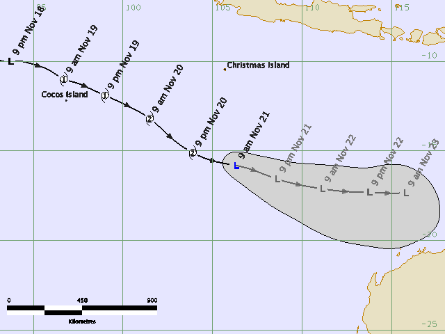
At 6:00 am WDT Tropical Cyclone Anika was estimated to be
240 kilometres northwest of Cocos Island and
moving east southeast at 22 kilometres per hour.

Tropical Cyclone Anika has formed to the northwest of the Cocos Islands and is
expected to maintain an east to southeast movement over the next few days.
Gales with wind gusts to 100 kilometres per hour could develop over the Cocos
Islands today as the tropical cyclone passes to the north of the Islands.

Details of Tropical Cyclone Anika at 6:00 am WDT:
.Centre located near...... 10.5 degrees South 95.5 degrees East
.Location accuracy........ within 45 kilometres
.Recent movement.......... towards the east southeast at 22 kilometres per hour
.Wind gusts near centre... 95 kilometres per hour
.Severity category........ 1
.Central pressure......... 996 hectoPascals
Location: Mcleans Ridges, NSW Northern Rivers
Australian Severe Weather:   http://australiasevereweather.com/
Lightning Photography:   http://www.lightningphotography.com/
Early Warning Network: http://www.ewn.com.au
Contact: Michael Bath

Offline Carlos E

  • Elephant Trunk F2
  • *
  • Posts: 135
  • Gender: Male
Re: Australian region tropical cyclone season: 2008 - 2009
« Reply #7 on: 20 November 2008, 08:42:43 AM »
BoM has noted a second Tropical Low behind Anika. They have given it a moderate chance of forming from 48 hours or so.

Last time there were two November Cyclones was the 2001-02 season.

Offline Peter J

  • Stove pipe F3
  • *
  • Posts: 419
  • Gender: Male
  • Lets go get em boys!
Re: Australian region tropical cyclone season: 2008 - 2009
« Reply #8 on: 22 November 2008, 06:49:25 AM »
Looks like Anika has lost the will to survive - and is now an ex-TC. It also is bringing plenty of cloud across central WA - which may combine with inland lows to bring more drenchings in central NT and northern SA.

Big Pete
PJJ

Offline Mike

  • Australian Severe Weather Moderators
  • Wedge tornado F5
  • *
  • Posts: 1,348
  • Gender: Male
  • Dry season here...boring!
    • http://StormscapesDarwin.com
Re: Australian region tropical cyclone season: 2008 - 2009
« Reply #9 on: 26 November 2008, 04:44:06 AM »
Alice Springs benefited from all that inflow, they've recorded their highest rainfall for November ever - and of course all those severe storms daily. 

There's a weak monsoon expected within a week but BoM not overly excited about it, probably January is when the main systems will come down. There has been some increased storm activity along the Indonesian region to the NW which spawned Anika, but these systems are slow to develop and if there's TC's in that zone they'll delay its arrival.
Darwin, Northern Territory.
StormscapesDarwin.com
Lightning Research 2010/14

Offline Peter J

  • Stove pipe F3
  • *
  • Posts: 419
  • Gender: Male
  • Lets go get em boys!
Re: Australian region tropical cyclone season: 2008 - 2009
« Reply #10 on: 08 January 2009, 05:00:06 PM »
I've read the latest on the QLD cyclone summary, and am still wondering if the cyclone time is getting active, and the summary is suggesting this - where are the cyclones? What is preventing them from "coming out of the closet"?

Big Pete

PJJ

Offline Jimmy Deguara

  • Australian and Tornado Alley storm chaser
  • Administrator
  • Wedge tornado F5
  • *
  • Posts: 2,218
  • Gender: Male
  • Storm Chaser since 1993, Tornado Alley 2001
    • Australia Severe Weather
Re: Australian region tropical cyclone season: 2008 - 2009
« Reply #11 on: 09 January 2009, 01:40:33 AM »
Well Pete, traditionally, the cyclone season is officially from January through to April. However, most tropical cyclones developed during February March period. Some of the earlier tropical cyclones tend to occur over the north west part of the country.

Michael B - would you say that is a fair enough assessment?

Regards,

Jimmy Deguara
-------------------------------------
Australian Severe Weather
www.australiasevereweather.com

Australian Thunderbolt Tours
www.thunderbolttours.com

Phone  0408 020468  (International :  61  2  408 020468)

Offline Colin Maitland

  • Barrel tornado F4
  • *
  • Posts: 614
  • Gender: Male
Re: Australian region tropical cyclone season: 2008 - 2009
« Reply #12 on: 09 January 2009, 04:10:57 AM »
The cyclone season for North Qld and Southeast QLD seems to be building. We are getting close to the season swinging into action. There is a lot of monsoonal activity in Central North QLD, and by Sunday according to charts there is low forming  east of cairns ( approx.) Not saying this will form a tropical low or cyclone, it is expected to move eastwards, but the patterns are emerging.

Maybe it is time for " the little girl" to play. ( La Nina), a return to an active season. It has been a very hot December/Jan so far with a lot of storm activity. The next 2- 3 weeks should see a cyclone form on the east coast. Could be a case of hold on to you hats.

Time to wax the board and head to the coast. Should take camera this time.
 
You may have to open with Fax viewer or similiar to get larger picture, or go to BOM site for QLD and look at  day weather chart (or simply cick on the map itself, who knows) .

Cheers, and happy photo snapping.
 
« Last Edit: 09 January 2009, 07:52:20 AM by coltan »

Offline Mike

  • Australian Severe Weather Moderators
  • Wedge tornado F5
  • *
  • Posts: 1,348
  • Gender: Male
  • Dry season here...boring!
    • http://StormscapesDarwin.com
Re: Australian region tropical cyclone season: 2008 - 2009
« Reply #13 on: 09 January 2009, 04:26:23 AM »
I would agree there, Jimmy. 

Pete, TCs are fickle things that are very sensitive to criteria before formation.  Regardless if the SSTs are 30C and there's nice monsoonal inflow, if the winds aren't right and if there's not enough persistent thunderstorm development over several days which does not wain then in all likelihood depressions take off.  Take last year for example - La Nina was supposed to have given northern Aust a huge spike in cyclonic activity but we only had one - Helen, yet forecasts were that this was generally the 'more likely' season for increased severe weather.  But it did not pan out that way at all! 

I guess it's something I can ask the bureau up here, but I'm confident they'll say the same thing - conditions just aren't favorable for their formation regardless of the monsoon!  Even with a new low in the Gulf of Carpentaria now which shows circulation on the NW quadrant, there's still not enough thunderstorm activity in these early days to warrant BoM taking more note of it.  Once the monsoon reaches the gulf it will enable the low to take advantage of the deepening trough and then things may form.

It's the $64,000 question, Pete and something nobody can answer.  The same questions are asked about the Atlantic season last year and the year before that and they had an above average number of hurricanes over CAT4 make landfall when experts were not expecting such a high number so close together! (apparently hurricanes can form quite easily in the path of others as the SST's only take about 24 hours to reach optimum temperatures again once the first hurricane tracks through).  Because our cyclones are so erratic compared to our northern neighbours i don't envy a Met officer trying to track one let alone forecast one!


Darwin, Northern Territory.
StormscapesDarwin.com
Lightning Research 2010/14

cloudfairy

  • Guest
Re: Australian region tropical cyclone season: 2008 - 2009
« Reply #14 on: 09 January 2009, 04:36:16 AM »
I was just about to post.....you were faster, Mike :)

I think it is about the monsoon trough. As long as it is staying this far over land the potential cyclones don't get the chance to spin up.

But to be honest, I'm frustrated about the non-existing thunderstorms, then the missing cyclones.