Summary Discussion, for anyone who wants to read what we have presented thus far in concise form. We welcome advanced technical discussion and information, or requests from experts.
This is a summary of some of the findings from the day which produced tornadoes over NE Victoria, focussing so far between Avenel and Longwood.
Meteorological situation:
Courtesy of Michael Bath:
Here's some data for the day
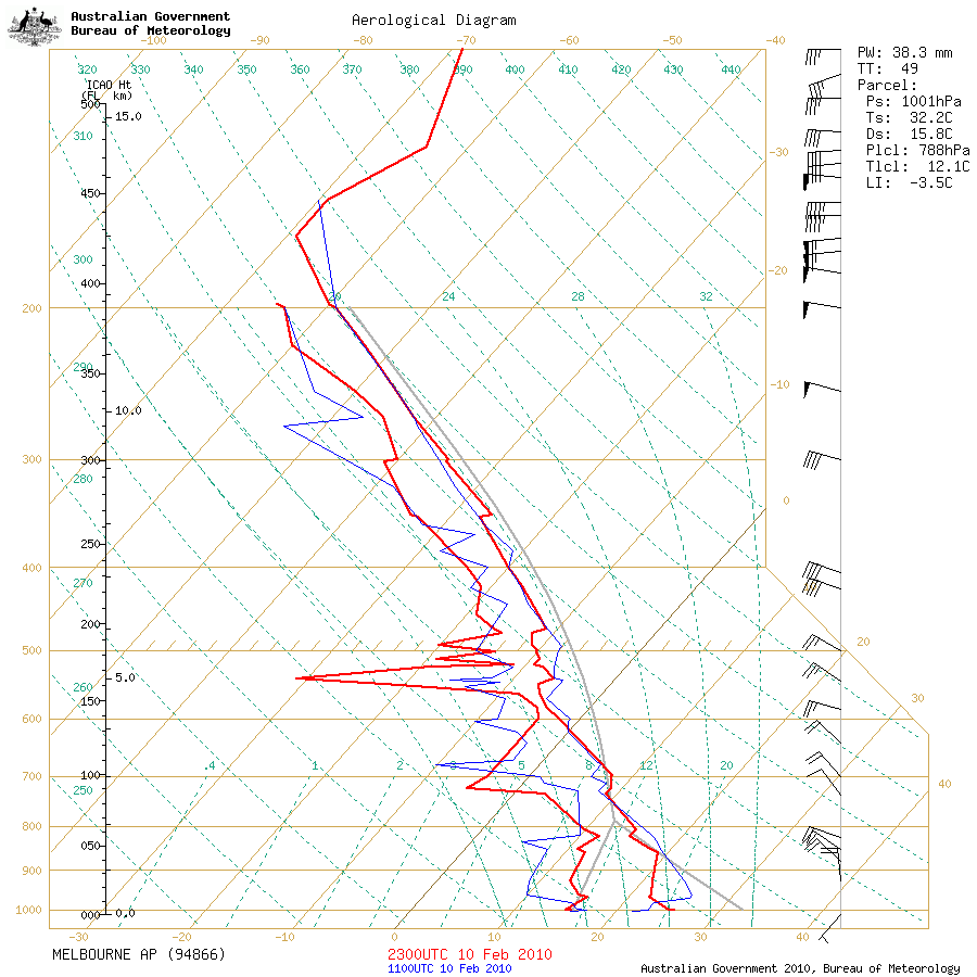
Melbourne morning sounding
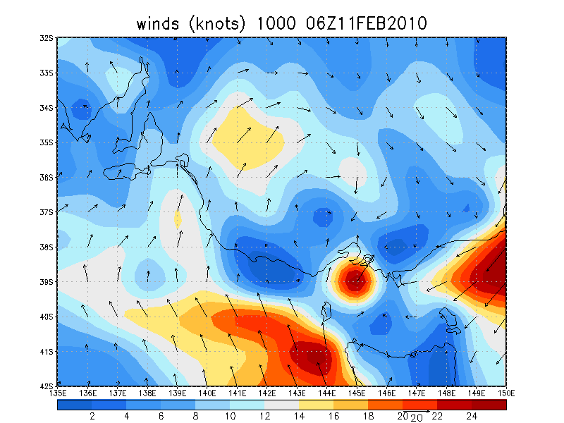
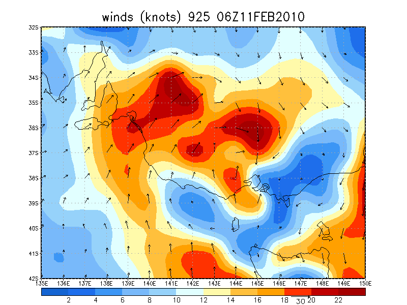
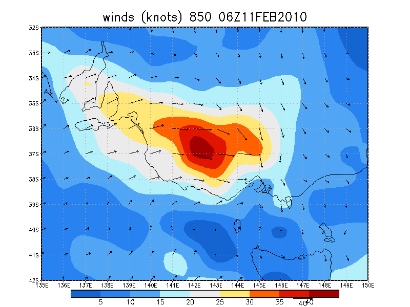
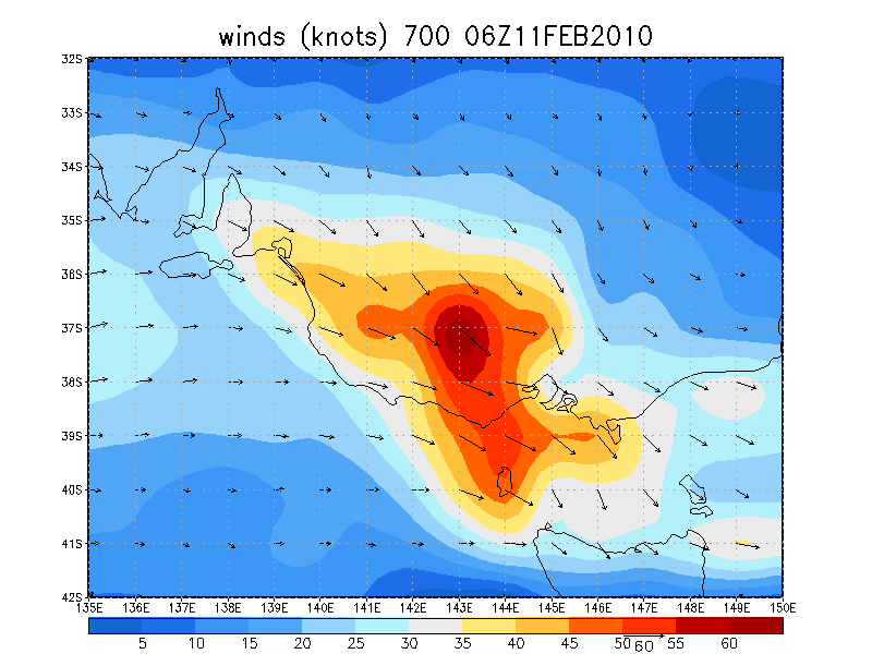
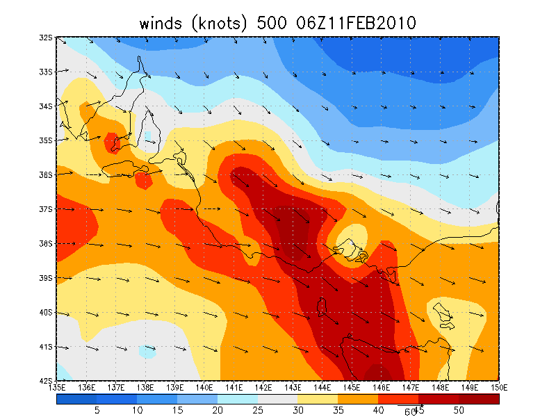
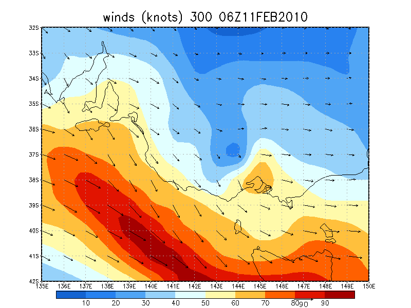
GFS 06z analysis run showing winds in knots is rather revealing
The Melbourne Doppler is still offline which is a real shame. Loops from Melbourne Airport and Yarrawonga radars are available.
128km Radar Loop for Melbourne AP, 00:00 11/02/2010 to 10:00 11/02/2010 UTC
 256km Radar Loop for Yarrawonga, 00:00 11/02/2010 to 10:00 11/02/2010 UTC
 Discussion of radar data, and recorded event
I've just had a 2 hour plus meeting with Harald Richter to discuss this day basically the 11th was an even more exceptional event that we thought. Based on the scans from the Yarrawonga radar, and using 3D rapic we have identified these cells to be low-topped supercells, with tops probably not extending above 5km. Harald agrees the images we captured show definite low level mesocyclones and wall clouds as part of low-topped tornadic supercells. He commented these cells are similar to those experienced in tropical cyclones which produce tornadoes, with very strong lower CAPE, but not much available (long skinny) in the upper levels because the surface heating never eventuated to shift the profile to the right, the soundings are reflective of those in the tropics. The shear was the key factor, along with interaction of a distinct outflow boundary from the NW to induce the lift. There is also substantial evidence of doppler returns having significant circulations and couplets, if only for a short period of time at lower levels, but the lack of the mid level mesocyclone likely prevented the sustained wall cloud structures and development of stable HP supercells rather than the low-topped variety.
Harald agrees we have at least 2 likely tornadoes, and likely a bunch of others circulations which may have reached the surface. It does not surprise me that the forecaster was so suprised to recieve a tornado report on the day given the reflectivity. It is a prime example that you don't need a 5000 J/kg environment with 60 knot shear to produce tornadoes, with this event falling right on the edge of supercellular developments. Its also an excellent example of why radar reflectivity and composite images do not show the actual truth of a storms circulation, and definitely underestimated yesterday.
Large hail was never a threat as little CAPE was available at the freezing level and in the super-crystalisation level. Convective winds were also unlikely with these cells outside of the RFD due to storm height and dynamical reasoning. Basically it was a tornado and precipitation environment.
This is a picture of an earlier tornado near Kilmore from another supercell:

This image has been adjusted using the rather primitive preview (mac) merely for contrast (about a 25% increase). The dots on the image are marks/raindrops on my lens filter which were cleaned off later. The shots brad took were better of this, I just don't want to post any of his images without his agreement. This is the low-topped HP supercell about 6-7km west of Longwood, looking SW of our position 2km N of Longwood.

These are produced as the cell has moved much closer, highly contrasted, they appear to show multiple vortices which are linked to cloud funnels:


A much strong tornadic circulation, with the prior multi-vortice roping out.

Another funneled circulation in a later supercell, we have yet to check for a damage track, and may be unable to as it occured in a mountainous region.

Damage Assessment (will be added to with a track image, and further damage surveys as they are completed):The damage survey took place between Avenel and Longwood (there is evidence to suggest that the there may have been event touchdown prior to Avenel, however this requires confirmation and further survey, the same occurs South of Longwood, with survey required to establish whether damage exists on the other side of the Hume Highway from another possible tornado on the ground identified in imagery). The choice of damage survey was based on what the photographs from North of Longwood indicated, with damage near Avenel corresponding well with cell path, and the behaviour reflecting what was seen in the storm.
A brief synopsis is provided now, a more complete damage survey with reasoning will be placed later along with imagery, this will just have a few things we found on our survey. Note that I will also provide a list of damage indicators used to derive the rating along the track.
Preliminary assessment has indicated 4 distinct damage tracks in the region between Avenel and Longwood, with initial damage beginning within 50m of housing near Avenel. We suggest that this verifies at least 4 individual circulations on the ground, forming in the classic path structure seen with tornadoes (will provide a map tomorrow). Path damage indicates likely multiple vortex tornadic behaviour, with individual swirls within damage varying in intensity. Tree damage is very characteristic of tornadic events, with rampant debarking in the upper levels of the trees, and larger branches being strewn in many different directions in areas which are untouched by cleanup crews (which removed some large trees from the major road). We rate the tornadic paths as follows (following the EF-scale rating theory due to the available references, with F scale noted):
Path 1: Initial damage is EF0, however later parts of this track reach EF1 and may even reach low end EF2 intensity (It would require another experienced damage survey person to confirm this). Some Large trees are snapped in two, along with numerous large branches snapped off and one tree split in two, plus some uprooted trees, which following both hardwood and softwood guidelines suggests low end EF2 damage as the ceiling (no structures were affected other than fences and the wires by the train line which had been damaged slightly by debris. This is followed by a contraction to EF1-0 damage at the end of the 4.5km path. Multiple vortex tornado. This correspondings to maximum low end F2 damage. Tornado width appears to have been at maximum around 100m.
Path 2: Distinctly seperated from Path 1, once again this track seems to be multiple vortex. EF1 damage seems to be the mainstay of damage here, with one small shed loosing part of its corrogated iron roofing which has been displaced some 10m. Again a 4km track. Maximum F1 damage. Tornado width at one stage reaches 150m.
Path 3: Shorter track appears to be EF0. Little sign of obvious multiple vortex behaviour, however less trees were present on path. Extends roughly 3km. Maximum F0 damage. Small width (no more than 50m)
Path 4: Tornado which was primary event photographed. Little damage as passed over a field full of red dust, evident swirl patterns in this dust, photographic evidence suggests multivortex behaviour, with possible satellite tornado. Damage survey was not fully completed after this swirl was identified. Extends some 1.5-2km. Appears to be EF0 on available evidence. Maximum F0 Damage.
Here is a selection of a few shots from the damage survey. Please note that the total number of shots for the survey so far is 300 individual images, very few of which are repeated (which indicates the extent of the damage along the tracks).
A large tree which had been torn in two, with all large branches snapped from the top. Destroyed the nearby barbed wire fence. Near where rating appears to be low end EF2/high end EF1
Primary damage path, 3km east of Avenel


Large tree trunk snapper mid way up, primary damage path.

A mess of branches primary damage path

Another snapped tree and damage along the road.

Brad and I have agreed that this elevation in the number of confirmed tornadoes suggests that this day is sufficient to be called an outbreak. Current tally is 5 confirmed tornadoes (1 at Kilmore, and 4 from the one tornado family between Avenel and Longwood) from two different supercells. There are a large number of other possible events we need to confirm and will provide images of the suspect areas.
we found little significant damage away from the main path (side roads were investigated) which amazingly followed the general direction of the road and rail line for the distances John noted. The nature of the damage path is such that there is a bitumin road adjacent to a dual rail line with in turn is abutted by a dirt road - all running parallel to each other with farmland on both sides. Therefore the width of the road/rail is quite wide and the damage was often observed across the whole width, accounting for the estimates of width of the damage path being consistently 100m (or more at times).
Having looked at your links provided I would have to say we observed significant widespread tree damage and scattered tree debris very similar in nature to the Dunoon pics but no structural damage of any real note.
For those interested in the damage survey and the area in question, here is a map link showing the towns mentioned. The damage path/s follow the direction of the railway line (north east from Avenel) which has a bitumin road alongside on the south eastern side and a dirt road alongside on the north western side.
http://maps.google.com/maps?q=avenel+victoria&oe=UTF-8&ie=UTF8&hq=&hnear=Avenel+Victoria,+Australia&ei=acV4S8ewE4ugkQX8vOz5Cg&ved=0CAkQ8gEwAA&ll=-36.843087,145.352211&spn=0.196724,0.43808&z=12Our location during the storm when we were seeing, photographing and videoing intense storm behaviour was from Kirwans Bridge Longwood Rd generally looking SE to SSE towards Locksley and Avenel. Having reviewed photos (with high contrasting) and then found the damage path, the pieces of the jigsaw are coming together.
As John mentioned, reviewing our photos (in high contrast where necessary) revealed some amazing storm behaviour including a likely very large wide circulation with defined angular side walls (which we can now say corresponds well with the location of Avenel and Locksley) well before the action from the same storm closer to Longwood which produced the multi-vortice dusty tornado. It became apparent that a damage survey was appropriate so off we went. However, we werent anticipating the length and width of the damage path we would find, nor did we expect that we would find such impressive damage from as far southwest as Avenel. The nature of the damage includes significant amounts of grass flattened and clearly facing different directions, long thin grass reeds embedded and protruding under the rail line between the sleepers, many dozens of large gums damaged or brought down over long distances with many 100's of limbs and branches hanging in other trees or laying in different directions along the damage path. The evidence of vorticity throughout the damage path leaves us in no doubt that this was a tornadic event and matches our observations, photos and video at the time. Further investigation is needed closer to Longwood and on the eastern side of the Hume where our photos also indicate possible further tornadic behaviour including another suspicious looking large circulation to our SE becoming rain wrapped by a huge RFD as we raced NE up the Hume.
In answer to a question on whether branches had been moved, it was quite simple to distinguish between those moved and those not moved, basically in the cases where a branch had been moved the soft mud on the side of the road from the rainfall resulted in drag and track marks, and quite often branches had been lopped off the upper ends of these larger branches, these were not used for evidence of tornadic winds (we found untouched areas for this purpose), rather just strength from the size of limb removed. Another part that allows us to make an objective survey in this regards is the damage where nothing has been altered, for instance where there are fences still damaged or destroyed by fallen branches or trees, and in areas of the bush where no movement has occured other than branches falling. Some of the branches/trees might have been weakened by the drought, however, we also found a large number of healthy limbs that had been removed of some size, which suggests relatively strong wind speeds. Part of the application of a damage rating scale is to obtain multiple indicators of a particular class of damage, which helps offset variations in the damage path.I am not however an arbourist, and hence can't emphatically say whether a tree was healthy or not...from what I could see the leaves and branches seemed to indicate relatively healthy trees....given the amount of rainfall in this region this spring and summer I dont know if the drought would be such an effect in weakening trees in that area.
I would like to point out once again to anyone who believes that we are jumping at shadows that we have images that when contrasted show the likely Avenel touchdown, and many others....what we intially claimed (2 tornadoes) is far below what some might claim given some of the imagery we have...Brad and I desire to ensure we can verify each and every tornado as we go. Note that the current confirmed tornadoes tally stands at 5 individual tracks (not just photographed....you can see that in the pictures above a massive question for us is how many individual tornadoes are there....for instance...are the tracks we have identified thus far individual tornadoes or simply swathes of multiple vortices?...the separation of the damage path that we surveyed suggests individual multiple-vortice events as part of a tornado family, but you can see why we have had to be careful with our presentation.
Interview information:The guy I spoke to (who clearly wasnt interested in talking) lived within 50m of flattened long grass and some minor (compared to the rest) tree damage but was at the very start of the damage path as we observed. Keeping in mind the long damage path that was heading directly away from this house and the heavy rainfall it is quite possible that they heard nothing 'abnormal' in their opinion. Furthermore, along the entire lengths of the damage paths I recall seeing only one farm (set back 100's of metres from the road), one closed council maintenance yard, one small industrial plant and a cattle yard and thats about it. Hopefully the next stage of our investigation may find more locals closer to Longwood and the Hume.
This summary will be continue to be updated, and contains posts from John and Brad. Any comments of expert opinions are welcome. More images of particular circulations will be posted tonight.


