Author Topic: NSW/QLD Storms, Widespread Rain and Floods 25-31st Dec 2009  (Read 12242 times)

0 Members and 1 Guest are viewing this topic.

Offline Mathew Townsend

  • Elephant Trunk F2
  • *
  • Posts: 151
  • Gender: Male
  • Watching storms since 1998
NSW/QLD Storms, Widespread Rain and Floods 25-31st Dec 2009
« on: 26 December 2009, 05:28:14 AM »
I am surprised that no one have created the thread of potential widespread rain event for NSW and QLD from today through to New Year period. It appears that Santa is giving us some good drinks!

This low pressure trough which was formerly Severe Tropical Cyclone Laurence that landfall near Port Hedland on 23rd of Dec. GFS forecasting huge totals mainly centred over NSW including Moree Plains, Bourke, Dubbo towards Sydney. This will include southern Qld including Brisbane, Sunshine Coast and Darling Downs. See attached of latest update of GFS forecast.

Have a good safe Christmas day everyone!

Offline Jimmy Deguara

  • Australian and Tornado Alley storm chaser
  • Administrator
  • Wedge tornado F5
  • *
  • Posts: 2,218
  • Gender: Male
  • Storm Chaser since 1993, Tornado Alley 2001
    • Australia Severe Weather
RE: NSW/QLD Storms, Widespread Rain and Floods 25-31st Dec 2009
« Reply #1 on: 26 December 2009, 04:24:11 PM »
Matt,

I know people are busy with Christmas hence not as many posts.

That is an extensive amount of rainfall if anything remotely similar occurs. It looks to be centred on Nyngan by the looks. Either it is drought or major floods. The interesting situation is that it is being predicted well ahead of time. I mean before the rain event had begun, flooding rains are predicted is not the usual situation. Hope we can break the drought in many areas as well as the intense heat waves.

Regards,

Jimmy Deguara
-------------------------------------
Australian Severe Weather
www.australiasevereweather.com

Australian Thunderbolt Tours
www.thunderbolttours.com

Phone  0408 020468  (International :  61  2  408 020468)

Offline Shaun Galman

  • Stove pipe F3
  • *
  • Posts: 441
  • Gender: Male
    • ridgelightning.com
RE: NSW/QLD Storms, Widespread Rain and Floods 25-31st Dec 2009
« Reply #2 on: 27 December 2009, 06:30:55 AM »
Hi all,

What a welcome relief these rains are! We've had a ridiculous rainfall total overnight! It started to absolutely pour down around 9pm EDT (25th Dec.) and didn't stop until 10am this morning (26th Dec.)

We did hear Coonamble has had the highest totals so far but I missed the numbers. I'd be incline to have a guess at our rainfall total being up near 80-100mm up until now (12:20pm EDT) I will confirm these once I can actually get out of my driveway and go check the rain gauge lol. 

There have been several river flooding warnings for our area including the Macquarie, Gwydir, Namoi, and Castlereagh rivers. The Namoi and Gwydir both meet at Walgett. Once the Castlereagh floods it usually cuts the road between Coonamble and Gilgandra.

This is definitely a significant system. If this doesn't help trigger severe storms throughout Jan. and Feb. I don't know what will!

Kindest regards,
Shauno.   
Chasing Region: Lightning Ridge. N.S.W.
Website: www.ridgelightning.com

Offline Michael Bath

  • storm chaser
  • Administrator
  • Wedge tornado F5
  • *
  • Posts: 1,602
  • Gender: Male
    • Australian Severe Weather
RE: NSW/QLD Storms, Widespread Rain and Floods 25-31st Dec 2009
« Reply #3 on: 27 December 2009, 09:03:20 AM »
Enngonia on 128mm to 9am 26/12 is the top official fall so far. No doubt other centres had 150mm or so.  Great to see it spread to your area Shauno. Nothing much on the coast apart from showers, and very gusty NE winds.

Location: Mcleans Ridges, NSW Northern Rivers
Australian Severe Weather:   http://australiasevereweather.com/
Lightning Photography:   http://www.lightningphotography.com/
Early Warning Network: http://www.ewn.com.au
Contact: Michael Bath

Offline Shaun Galman

  • Stove pipe F3
  • *
  • Posts: 441
  • Gender: Male
    • ridgelightning.com
RE: NSW/QLD Storms, Widespread Rain and Floods 25-31st Dec 2009
« Reply #4 on: 27 December 2009, 12:14:11 PM »
Hi all,

MB: That's a pretty hefty total at Enngonia! I'll see if I can get a few (reliable) totals for this area.

We only just copped a superb HP monster! My dad and I ended up bogged out on the opal fields around 20k's north of town lol. Everywhere low-lying is pretty well flooded in. All the dams are invisible here, submerged under about 6inches of water in most places. The rain was so heavy from the storm earlier we could hardly see with the wipers going full pelt. It wasn't so much a white-out as a black-out! Boy it was so dark and ominous. A very nice lowered base/scud feature on the forward line as the monster plowed over the tree tops. Some thunder present but I didn't see any CG, just the odd intra cloud lightning I'd suspect.

It skirted town by 5k's (cutting off at the turn-off into town from the Castlereagh Highway) but has added to the flooding surrounding the ridges nicely.

Seems like models are forecasting much more to come over the next week or so. Going by WZ, next Wednesday looks to be a beauty if the models hold true.

Take care if traveling out on the roads in the wet guys.
Shauno 
Chasing Region: Lightning Ridge. N.S.W.
Website: www.ridgelightning.com

Offline Mathew Townsend

  • Elephant Trunk F2
  • *
  • Posts: 151
  • Gender: Male
  • Watching storms since 1998
RE: NSW/QLD Storms, Widespread Rain and Floods 25-31st Dec 2009
« Reply #5 on: 28 December 2009, 05:33:46 AM »
Interesting Shaun.

There alot of heavy totals in Wide Bay region aswell up in Qld where the upper low pushing the rainband onshore. It appears to spread out into SE Qld this afternoon and into NE Nsw sometime later in the afternoon and evening.

Lovely showery kind of weather here in Modanville with nice and cool conditions. Wind can be gusty at times which accompanied by NE stream.

Offline Antonio (stormboy)

  • Stove pipe F3
  • *
  • Posts: 481
  • Gender: Male
RE: NSW/QLD Storms, Widespread Rain and Floods 25-31st Dec 2009
« Reply #6 on: 28 December 2009, 06:55:29 AM »
Now if we are lucky because it has been raining a fair amount inland it would have settled the loose dust hopefukky ending the dust storms for a while. This should also bring moisture for future storm activity. The forecast for Ballina for the next 7 days is either RAIN or increasing showers. Looks like it will be a wet New Years Eve.

Antonio
« Last Edit: 28 December 2009, 11:18:30 AM by Jimmy Deguara »

Offline Mathew Townsend

  • Elephant Trunk F2
  • *
  • Posts: 151
  • Gender: Male
  • Watching storms since 1998
RE: NSW/QLD Storms, Widespread Rain and Floods 25-31st Dec 2009
« Reply #7 on: 29 December 2009, 08:36:45 AM »
Hey guys

Looking good to see totals building up alot across SEQLD overnight but also helped in Northern Rivers and northern parts of Ts. Southern MNC including Kempsey to Taree area have good totals over 60mm! Brisbane and some parts already having over 100mm, the dams are drinking alot of water i presume!

Alot of rain to go ahead with some heavy thundercells, some gusty winds aswell.

Offline Shaun Galman

  • Stove pipe F3
  • *
  • Posts: 441
  • Gender: Male
    • ridgelightning.com
RE: NSW/QLD Storms, Widespread Rain and Floods 25-31st Dec 2009
« Reply #8 on: 29 December 2009, 10:57:50 AM »
Upper Western / North West NSW Storm Report. 28th December 2009

Hi everyone,

Well it's been another VERY stormy 24hrs! I couldn't believe the crazy numbers of storm cells firing around NSW and QLD over the last two days!

All the cells that we are copping are HP and are very active (which is real nice photography-wise)

Had a beautiful little storm pass by us late yesterday (27th Dec. 2009) evening around 7:30pm. This gave Russ and I a chance for some great sunset/CG and crawler photos between 8-9pm. We chased up until midnight and even then I think my friends (up from Albury) were still taking distant lightning shots around 2am! Every cell that was present all around us was active, some only firing once or twice but it was so impressive to watch. The CG were even firing through weak virga breaking from the mid level bases at times  ;D

I have gathered some totals for the days across Christmas (25th to the 27th December) and the general average seems to be around 135mm in town. However the reading across the Opal fields to our North would be significantly higher, possibly 30-40mm higher in places as it's pretty flooded out there from the further 3 or 4 HP cells crossing those regions that didn't make it into town.

The storm that rolled in around lunchtime today (28th Dec. 2009) was highly active, firing numerous staccato CG's from a pretty dark front edge. There were a few further mm to come from this storm but it wasn't as heavy as I initially though when I saw it approach. I think the bulk of the rain passed to our NE (where the lightning was most frequent and some greenish hue was present in the updraft)

I will post a few shots from yesterday asap. I didn't manage any today (so far) due to the steady rain.

Kindest regards,
Shauno.
Chasing Region: Lightning Ridge. N.S.W.
Website: www.ridgelightning.com

Offline Shaun Galman

  • Stove pipe F3
  • *
  • Posts: 441
  • Gender: Male
    • ridgelightning.com
RE: NSW/QLD Storms, Widespread Rain and Floods 25-31st Dec 2009
« Reply #9 on: 29 December 2009, 03:52:20 PM »
Upper Western / North West NSW Storm Photos for the 27th December 2009

Hi guys,

Here's a couple photos I took of the HP cell that crossed town to the West and headed South towards Walgett, gaining in severity as it went!

The first was taken at Bald Hill (around 2k's NW of town) and is looking generally West. There were constant CG coming from a weaker looking cell in front of this storm (left of photo). This has been typical of the cells over the last few days, though the storms that came through today were far larger in size!
The second photo was taken out on the Four Mile opal fields looking generally SSW. The rain was not being lens friendly so I missed the best of the show lol? I think we left around 9pm as it got too distant. The storm raged on into the night, we sat and watched it until midnight while chasing other cells that grew around us.

Kindest regards,
Shauno
« Last Edit: 29 December 2009, 04:05:26 PM by Shaun Galman »
Chasing Region: Lightning Ridge. N.S.W.
Website: www.ridgelightning.com

Offline Mathew Townsend

  • Elephant Trunk F2
  • *
  • Posts: 151
  • Gender: Male
  • Watching storms since 1998
RE: NSW/QLD Storms, Widespread Rain and Floods 25-31st Dec 2009
« Reply #10 on: 30 December 2009, 04:30:46 AM »
Nice pics Shaun!

It good to see most of the region is green now!!! The rain and widespread showers mainly heavy still happening. Over 70mm of rain so far for this event including 20mm overnight and more to go ahead due to the radar.

Lot of parts recorded over 100mm already which is good news.

Offline Michael Bath

  • storm chaser
  • Administrator
  • Wedge tornado F5
  • *
  • Posts: 1,602
  • Gender: Male
    • Australian Severe Weather
RE: NSW/QLD Storms, Widespread Rain and Floods 25-31st Dec 2009
« Reply #11 on: 30 December 2009, 05:20:51 AM »
Thanks for sharing those photos Shauno. Good to see photogenic results where most areas are probably copping low cloud and rain. Which is certainly the case locally though a couple of tropical looking cells were visible yesterday afternoon (28th).

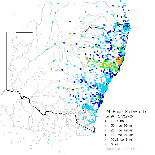
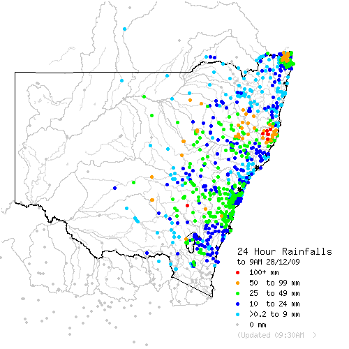
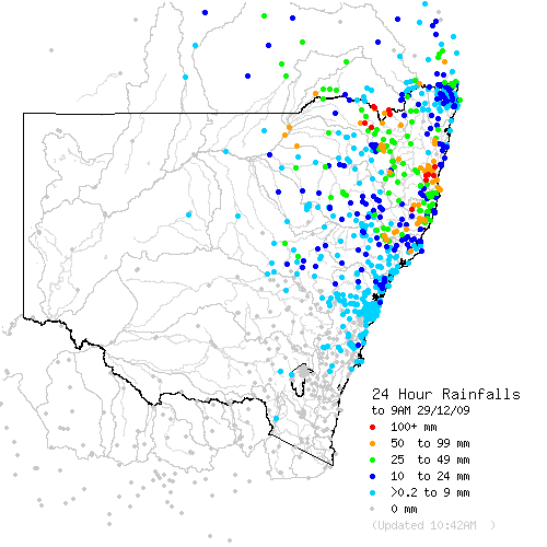
I've included the past 3 days of 24 hour rainfall maps to show the persistence of this troughy system in generating widespread rainfalls.  Many locations are receiving over 100mm and not surprising there are quite a few flood warnings - including for the Bellinger River - its 7th flood for the year!. Amazing how that area managed to sneak in another flood before year end.

Along with these warning there is also a flood watch for a few other rivers, including the Wilsons/Richmond (surprisingly)

Flood Warning - Tweed River,
Flood Warning - Bellinger River,
Flood Warning - Hastings River,
Flood Warning - MacIntyre River,
Flood Warning - Castlereagh River,
Flood Warning - MacQuarie River,
Flood Warning - Bogan River,
Flood Warning - Culgoa, Bokhara, Narran,
Flood Warning - Paroo River.


I hope Harley will put together some rainfall stats for the event when it finally eases off.


Location: Mcleans Ridges, NSW Northern Rivers
Australian Severe Weather:   http://australiasevereweather.com/
Lightning Photography:   http://www.lightningphotography.com/
Early Warning Network: http://www.ewn.com.au
Contact: Michael Bath

Offline Harley Pearman

  • Barrel tornado F4
  • *
  • Posts: 584
Re: NSW/QLD Storms, Widespread Rain and Floods 25-31st Dec 2009
« Reply #12 on: 30 December 2009, 11:17:21 AM »
The rainfall plot below from the Bureau of meteorology "Water and the Land" site for the week ending 29/12/2009 shows graphically that the majority of New South Wales received some worthwhile falls.

The best falls occurred over the Central West and North West Slopes and Plains of New South Wales where falls of 100 to 200 mm occurred. A small area north of Taree to Port Macquarie but inland from the coast received between 200 and 300 mm of rainfall.

Unfortunately the far South West border regions of the state west of Albury to the South Australian border missed the event. Rainfalls were either light or non existent. That region still awaits a good rain event.

I noted the impact of the rain when travelling to and from Batemans Bay (NSW South Coast) via Goulburn / Lake Bathurst and Tarago on Christmas Eve and 27/12/09. On Christmas eve the region south of Goulburn was exceptionally dry and in need of water. However following the Christmas Day and Boxing Day falls, good rains in that region had soaked the soil well and I even saw that water had ponded in some small farm dams. More is needed but it seemed to be making a positive impact in a region that seriously needed it.
 
Harley Pearman

Offline Mathew Townsend

  • Elephant Trunk F2
  • *
  • Posts: 151
  • Gender: Male
  • Watching storms since 1998
Re: NSW/QLD Storms, Widespread Rain and Floods 25-31st Dec 2009
« Reply #13 on: 30 December 2009, 05:29:56 PM »
Watch out for creeks and that for minor flooding tonight with Severe Thunderstorm Warning issued for flash flooding in the northern part of the state.

Regards,

Jimmy Deguara
« Last Edit: 31 December 2009, 02:19:31 PM by Jimmy Deguara »

Offline Paul D

  • Multi-vortex F1
  • *
  • Posts: 90
  • Gender: Male
Re: NSW/QLD Storms, Widespread Rain and Floods 25-31st Dec 2009
« Reply #14 on: 01 January 2010, 04:51:41 PM »
Looks like the event over the last week as previously mentioned, ended up bringing some good rainfall totals, some out where they need it and just enough on the east coast to remind us how much we got earlier in the year, along with only minor flooding in a few spots for the east coast so far.

Headlines for Macleay Argus :-29th Dec 2009,
"Locals happy as bridge reopens"
(Turner's Flat Bridge reopened 22nd Dec after lengthy repairs from damage during May Floods)

29th Dec 2009 all the signs say "Bridge is now open" but river decides otherwise :-) ..


(I see Dorrigo managed to get enough rain to be well over 3m for the year)
PD
« Last Edit: 01 January 2010, 04:59:36 PM by Paul D »