Author Topic: Melbourne Severe Storms and Possible Tornado Northern VIC - Monday 3rd December 2007  (Read 25913 times)

0 Members and 1 Guest are viewing this topic.

Offline Brad Hannon

  • Thunderbolt Tours Group
  • Stove pipe F3
  • ******
  • Posts: 427
  • Gender: Male
  • Colorado Beast - 2nd June 2005
Hi all, it's certainly been a big day for the East Coast and I'm happy to say Melbourne got in on some genuine severe action for once (check out the lightning tracker grabs below).  Woke up to some nice heavy rain this morning which cleared by mid-morning allowing for heating of an already potent moist environment which has been building for the best part of a week now. Late morning brought very low cloud bases (and scud) and an intense line of storms through my area in the NE of Melbourne, heading SE where they intensified more, leading to huge rainfall totals and flash flooding in the Eastern suburbs at the base of Mt Dandenong (see BOM radar grab below).  This line was impressive but cleared to blue skies and after good heating, round 2 kicked off some time around 2pm with cells developing to the NNW of Melbourne again moving SE.  I jumped in the car to head to a high point nearby for a look at the action and within 1 min drive I was astonished to see what I recognised very quickly as a definite wall cloud located close to or over Bulleen.  This wall cloud was clearly (though not violently) rotating and I could see brief glimpses of towering structure above through the very low bases. Interestingly the cell was moving slowly in an easterly direction (possible left moving supercell?) while the predominant direction of flow of the system was SE. I proceeded through Rosanna and Lower Plenty to intercept the circulation and grabbed some pics as I went (see below) including a suspect funnel shape below the wall cloud as it neared Templestowe.  Not having seen a rotating wall cloud in the southern hemisphere before was an interesting experience to see the clockwise rotation.  There was a persistent cut into the wall cloud on the western side which I hypothesized may have been an RFD cut (not sure though) which coincided with the most organised stage that I witnessed.  It was the lowest and most organised wall cloud I have seen in Australia - and the first rotating.  There were no reports of this specific event to BOM (and no comment on WZ forum) that I am aware of and unfortunately I didn't have time to stop or the number to call it in myself.  The rotation in the wall cloud persisted for 30mins from the time I saw it first to when it became obscured by heavy rain carried by strong SW winds (an RFD perhaps, I don't know?).   I was a little surprised it lasted so long but when the BOM commented on the radio later that some of the cells had indeed possessed characteristics of supercells it made more sense.  It was a fantastic chase on my own doorstep for once.

Brad.
hmmm June 2nd......

Jeff Brislane

  • Guest
Brad, I was hoping you were out chasing this stuff. Good to see you have documented a supercell near Melbourne. The storms down there have been quite active and severe in the last week or so.

Did you get out and chase that storm recently west of Melbourne? It was last week some time and moved north from Geelong towards Ballarat. It showed some interesting motion on the radar.

Jeff.

Offline Brad Hannon

  • Thunderbolt Tours Group
  • Stove pipe F3
  • ******
  • Posts: 427
  • Gender: Male
  • Colorado Beast - 2nd June 2005
Did you get out and chase that storm recently west of Melbourne? It was last week some time and moved north from Geelong towards Ballarat. It showed some interesting motion on the radar.

Jeff.

Hi Jeff, no I wasn't able to chase the Western storms last week - I was in hospital with my wife and new baby :)  But I was watching skywards non the less.

Brad.
hmmm June 2nd......

Jeff Brislane

  • Guest
Cool, congrats man. I'm going to be in the same boat in a months time and then it'l be jimmys turn to produce a prodigy!

Offline Jimmy Deguara

  • Australian and Tornado Alley storm chaser
  • Administrator
  • Wedge tornado F5
  • *
  • Posts: 2,218
  • Gender: Male
  • Storm Chaser since 1993, Tornado Alley 2001
    • Australia Severe Weather
Hi Brad,

Not sure if it is the perspective but it seems that cloud feature is attached to a shelf cloud though I would need a better view obviously to be certain.

Regards,

Jimmy Deguara
-------------------------------------
Australian Severe Weather
www.australiasevereweather.com

Australian Thunderbolt Tours
www.thunderbolttours.com

Phone  0408 020468  (International :  61  2  408 020468)

Offline Michael Bath

  • storm chaser
  • Administrator
  • Wedge tornado F5
  • *
  • Posts: 1,602
  • Gender: Male
    • Australian Severe Weather
"Tornado twists some heads" - article from the Country News


An apparent tornado that whipped through open paddocks near Tungamah last Monday evening was "like something from a movie" a woman who witnessed it said.
Jenny Lawrence, husband Chris and daughter Zoe were travelling to Yarrawonga from their farm, about 10 km west of Tungamah, just after 6 pm when Zoe spotted the twister.
"Zoe just said to us `Did you see that? Stop the car, stop the car'," Mrs Lawrence said.
"It was just beautiful; it was pure white and this tunnel of cloud stretched from the sky right down to the ground."
Bureau of Meteorology senior meteorologist Kevin Parkyn said it was entirely possible the Lawrences did indeed witness a tornado in action.
"They're probably a lot more common than many people realise," Mr Parkyn said.
They will go to Tungamah this week to learn more about the Lawrence family's sighting.
Chris Lawrence said he had never seen anything like it, despite living in the Tungamah area for his entire life.
Mr Lawrence said the twister "snaked" along the ground for about 30 seconds before dissipating into the clouds.
Mrs Lawrence said Zoe managed to snap a picture on her father's camera phone just as the twister disappeared.
"It was swirling towards us and then it was like someone just popped a balloon," Zoe said.


----------------------------------------
The photo is certainly interesting showing an apparent funnel extending to the ground. Would be ideal of course to see other photos in sequence and some storm structure shots.

Some data for the event

---> Yarrawonga 128km radar loop
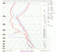

Melbourne 00z


GFS analysis Monday 03/12/2007 06z

Instability: CAPE / Lifted Index

Relative Humidity: 0300 / 0500 / 0600 / 0700 / 0850 / 1000

Temperature: 0300 / 0500 / 07000850 / 1000

Winds (knots): 0200 / 0300 / 0500 / 0600 / 0700 / 0850 / 0925 / 1000

MB
Location: Mcleans Ridges, NSW Northern Rivers
Australian Severe Weather:   http://australiasevereweather.com/
Lightning Photography:   http://www.lightningphotography.com/
Early Warning Network: http://www.ewn.com.au
Contact: Michael Bath