Author Topic: NSW/QLD Showers/rain/storms 28th Nov - 3rd Dec 2009  (Read 19502 times)

0 Members and 1 Guest are viewing this topic.

Offline Mathew Townsend

  • Elephant Trunk F2
  • *
  • Posts: 151
  • Gender: Male
  • Watching storms since 1998
NSW/QLD Showers/rain/storms 28th Nov - 3rd Dec 2009
« on: 28 November 2009, 06:36:21 AM »
Im surprised that no one making a thread of this potential upcoming event with marching upper trough coming in from SA and VIC. Shear looks rather complex but its reasonable. Instability looks incredible offshore from Sunday but won't be surprised that will come onshore! Im more focusing on tomorrow at this point and im keen to chase around Ballina/Byron/Lismore areas!
« Last Edit: 06 December 2009, 03:02:05 AM by Michael Bath »

Offline Paul D

  • Multi-vortex F1
  • *
  • Posts: 90
  • Gender: Male
Re: NSW/QLD Showers/rain/storms 27th Nov - 4th Dec 2009
« Reply #1 on: 28 November 2009, 09:29:12 AM »
Predictions for Cap and LI have changed a little over the last couple of days but at least it is looking more likely for the prospect (over the next few days) of some action/rain in coastal SEQ and Nth NSW. See what the effects of the lower level shear is..
« Last Edit: 28 November 2009, 11:02:26 AM by Paul D »

Offline Mathew Townsend

  • Elephant Trunk F2
  • *
  • Posts: 151
  • Gender: Male
  • Watching storms since 1998
Re: NSW/QLD Showers/rain/storms 27th Nov - 4th Dec 2009
« Reply #2 on: 28 November 2009, 10:20:17 AM »
Tomorrow setup gained some potential according to the charts and models. BoM's earlier 4-day charts showed some precipitation here after 3pm EDT tomorrow. Forecasts for Northern Rivers have 'isolated showers and thunderstorms in the afternoon', i won't write this off if it failed to break the cap tomorrow afternoon.

EDIT at 5:08pm: Theres a cell developing at Lismore heading to Alstonville and Ballina at this stage. I will be very likely to watch this cell come across to get photo opportunities!
« Last Edit: 28 November 2009, 11:09:29 AM by Mathew Townsend »

Offline Mathew Townsend

  • Elephant Trunk F2
  • *
  • Posts: 151
  • Gender: Male
  • Watching storms since 1998
Re: NSW/QLD Showers/rain/storms 27th Nov - 4th Dec 2009
« Reply #3 on: 29 November 2009, 03:41:41 AM »
Phewww!! Thats pretty hot and sticky this morning, already up to 30/21 from Ballina AWS @ 9am! Nice mid level cu field around with some towers including Evans Head cell in the south. Look rather chaseable day ahead. Me and my mate Dylan going to check things out through the day where to chase. No surprised for storms will become violent perhaps.

I got my cameras charged and he is bring his own aswell his car! Chasing time ahead :) I will be looking around Ballina/Lismore/Byron areas today. Its where marked deep instability, high CAPE and reasonable shear.

teamdave

  • Guest
Re: NSW/QLD Showers/rain/storms 28th Nov - 4th Dec 2009
« Reply #4 on: 29 November 2009, 06:36:07 AM »
morning all.
Thinking of heading down to the lismore area today (only 1 hour south for me) This sound about right or should I sit tight in the coolangata area?
Im new to this site and chasing in Oz. From the uk and have chased in USA twice. Any help or advice on todays set up would be very appreciated.
Thanks Dave.

Offline Colin Maitland

  • Barrel tornado F4
  • *
  • Posts: 614
  • Gender: Male
Re: NSW/QLD Showers/rain/storms 28th Nov - 4th Dec 2009
« Reply #5 on: 29 November 2009, 08:04:20 AM »
It has been a very hot and humid day in Brisbane today, typical summers day and storms were on the cards. To the North of Bracken Ridge there is a few storm building. The radar is showing a cell  heading towards Caloundra on the Sunshine Coast, and to the south, as far down as  Redcliffe. The cell is exploding and building in size as it nears the coastline.

BOM  has issued the following warning  for the SEQ area

SEVERE THUNDERSTORM WARNING - SOUTHEAST QUEENSLAND
for DAMAGING WIND and LARGE HAILSTONES

For people in parts of the
MORETON BAY and
SUNSHINE COAST Council Areas.

Issued at 12:32 pm Saturday, 28 November 2009.

The Bureau of Meteorology warns that, at 12:35 pm, severe thunderstorms were detected on weather radar near Peachester, Landsborough and Beerwah. These thunderstorms are moving towards the east. They are forecast to affect the area southwest of Caloundra by 1:05 pm and Caloundra and waters off Caloundra by 1:35 pm.

Damaging winds and large hailstones are likely.


Offline Mathew Townsend

  • Elephant Trunk F2
  • *
  • Posts: 151
  • Gender: Male
  • Watching storms since 1998
Re: NSW/QLD Showers/rain/storms 28th Nov - 4th Dec 2009
« Reply #6 on: 29 November 2009, 08:44:17 AM »
Severe warning have been issued for NR area.

Quote
Australian Government Bureau of Meteorology
New South Wales
TOP PRIORITY FOR IMMEDIATE BROADCAST

SEVERE THUNDERSTORM WARNING
for DAMAGING WIND, FLASH FLOODING and LARGE HAILSTONES

For people in the
NORTHERN RIVERS and parts of the
NORTHERN TABLELANDS,
NORTH WEST SLOPES and
NORTH WEST PLAINS Forecast Districts.

Issued at 2:09 pm Saturday, 28 November 2009.

Severe thunderstorms are likely to produce damaging winds, very heavy rainfall, flash flooding and large hailstones in the warning area over the next several hours. Locations which may be affected include Lismore, Grafton, Tenterfield, Byron Bay, Ballina, Casino, Kyogle, Yamba and Maclean.

Look rather interesting in the west with some blue skies with large-ish towers in background. Going to check things you shortly. Grafton cell look rather stationary, won't be surprised for flooding down there. Out west on the range towers Moree districts look so awesome. Large line developing and marching towards the coast quickly.

Offline enak_12

  • Elephant Trunk F2
  • *
  • Posts: 153
  • Gender: Male
Re: NSW/QLD Showers/rain/storms 28th Nov - 4th Dec 2009
« Reply #7 on: 29 November 2009, 03:54:19 PM »
I photgrahed the Coffs Harbour storms today. They werent spectacular they only had moderate rain, wind and no hail. The cg's werent frequent either. They did look nice though.


Offline Paul D

  • Multi-vortex F1
  • *
  • Posts: 90
  • Gender: Male
Re: NSW/QLD Showers/rain/storms 28th Nov - 4th Dec 2009
« Reply #8 on: 29 November 2009, 04:29:41 PM »
Few cells came through the coast, nothing real spectacular again, but got a bit of welcome rain and a few close CG's out of this cell which was developing at around 1-30.
PD

Offline Jason(pato)

  • Elephant Trunk F2
  • *
  • Posts: 136
  • Gender: Male
Re: NSW/QLD Showers/rain/storms 28th Nov - 4th Dec 2009
« Reply #9 on: 29 November 2009, 05:14:44 PM »
Hey guys just got back from a chase with Michael Bath and we were on that cell in Grafton. Was quite nice just south of town where we experienced hail in the 2-3.5cm mark and some nice strong winds. Got some nice arvo CGs as well!! Will post a report  in the morning probably. Got a card full of photos to sort out lol.
« Last Edit: 30 November 2009, 04:27:26 AM by Jason(pato) »
South Lismore, Northern Rivers NSW.....Supercells are us!!

Offline Mathew Townsend

  • Elephant Trunk F2
  • *
  • Posts: 151
  • Gender: Male
  • Watching storms since 1998
Re: NSW/QLD Showers/rain/storms 28th Nov - 4th Dec 2009
« Reply #10 on: 30 November 2009, 04:15:25 AM »
Hey guys!!!

We had some violent looking guster came across Richmond River just after 7 30pm with a hidden sunset behind it. This guster came through very quickly brought us wind gusts up to 60km/hr from the south! Hour later it ended up very heavy short burst of rain, recorded 5.5mm in 10mins.


There would be some more storms here across the region again today. Looks like storm chasing will be more locally. Lifted Index down to -5 over Lismore/Ballina with CAPE around 1200. Huge instability remains offshore. Windshear looks ripper than yesterday!

Offline Jason(pato)

  • Elephant Trunk F2
  • *
  • Posts: 136
  • Gender: Male
Re: NSW/QLD Showers/rain/storms 28th Nov - 4th Dec 2009
« Reply #11 on: 30 November 2009, 04:39:53 AM »

November 28th 2009


Gday All,


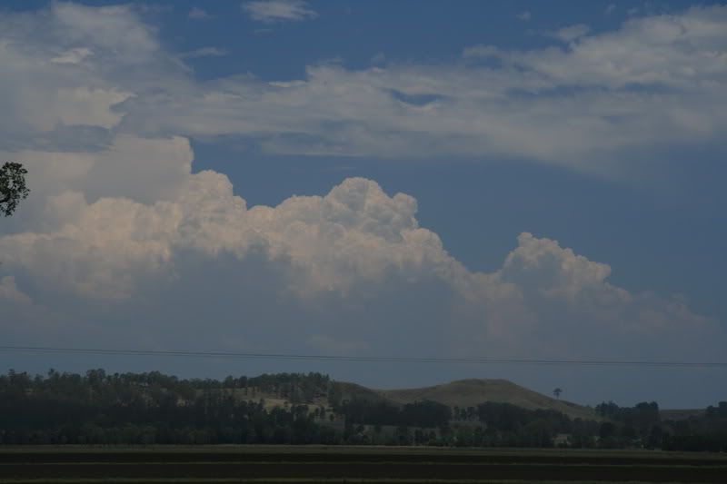
As promised last night heres the report from yesterdays chase with Michael Bath.  Got the phone call from MB at 1145am to see if I wanted to head out and naturally I said yes. He arrived not long after and we decided to head out to Casino to see what was happening. Eventually settled on a spot about 5km west of the township and watched some struggling local development. Meanwhile to the south more powerful looking updrafts were regularly punching up into the atmosphere.


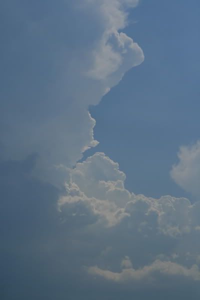
We stayed in this spot for about 45mins before deciding that the southern storms looked more substantial so after a quick stop at Chasers Choice we made our way south. The first cell looked to be passing near Lawrence so we headed that way to see if we couldn't get ourselves into the first storm of the day. We arrived perhaps 15mins too late as the cell was in a weakening phase but we still were able to witness what appeared to be a mid level funnel.


You can just make it out in the middle top right of picture. MB will probably have a better zoomed in shot to illustrate it better.

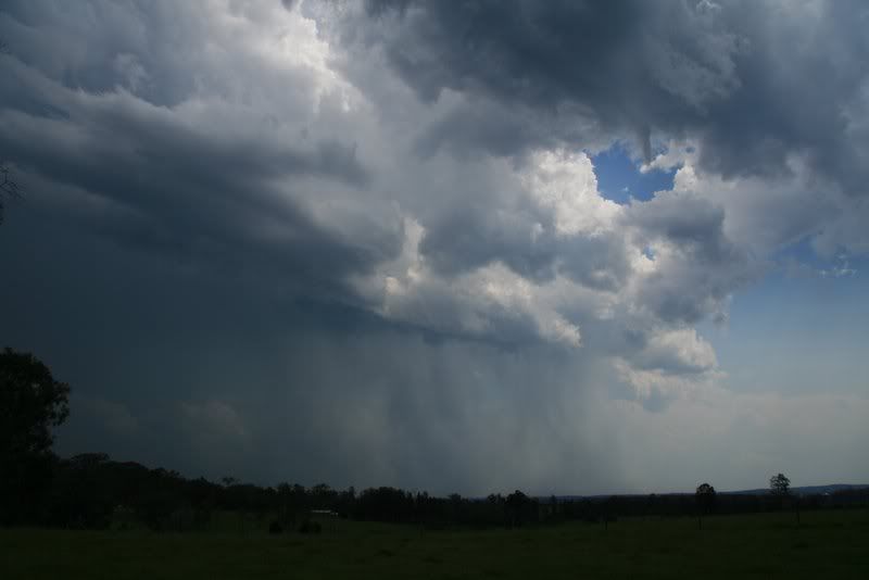
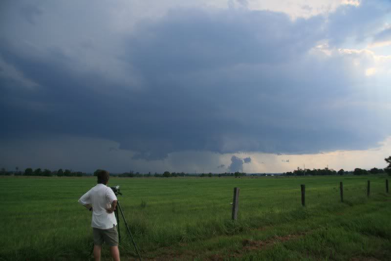
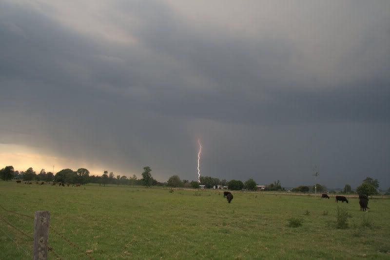
It looked like the cell near Grafton was starting to get its act together so we shot south to witness would be the storm of the day. On the way there we passed through Southgate where it appeared there might have been a microburst or similar as there was a fair bit of debris scattered over the road. We then positioned ourselves at Junction Hill to witness the beast that was brewing to the west of Grafton. There was some crisp updrafts and the anvil was thickening up very nicely.


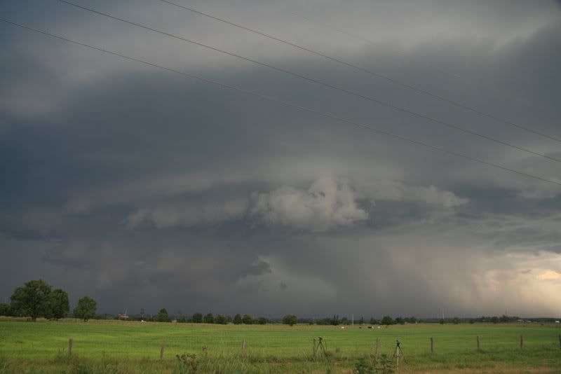
The storm really began to get organised now with what appeared to be a wall cloud feature and regular CG's punching out and it began to take on an ominous appearance.


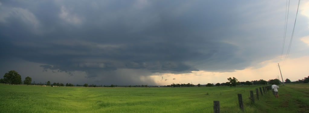
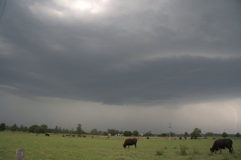
4 Shot pano of storm


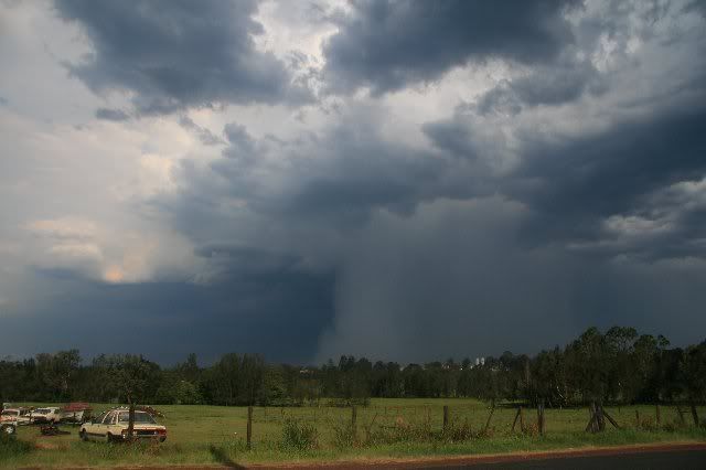
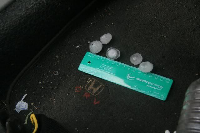
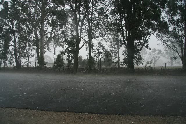
We watched this for a while then MB suggested we get get closer so we packed up the gear and off we went to punch it. Travelling through Grafton the outflow from the cell was pretty crazy possibly gusting 80-100km/hr with dust and branches being whipped along. We decided to take the Glenreagh/Ebor road to punch the beast and soon we entered very heavy rain with visibility reduced to less than 50m at times. Travelled a bit further along and soon the telltale thunk of hail started to hit the car with winds probably in the 80km/hr region. We conservatively guessed the size to be mostly in the 2-2.5cm with the possibility of some isolated bigger ones about. We weren't able to get a measurement till prob 10 mins after it passed so a little bit of melting had probably happened. We travelled a bit further south where we witnessed a tree had brought down power lines, I didn't get a pic of this but MB did. The retreating storm had a nice visible hailshaft lit up by the sun.


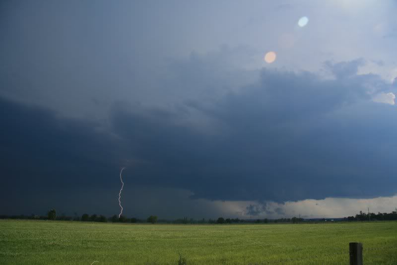
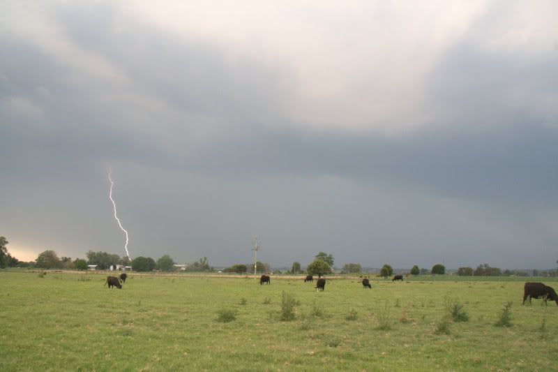
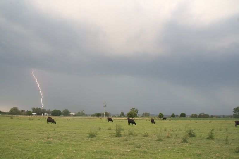
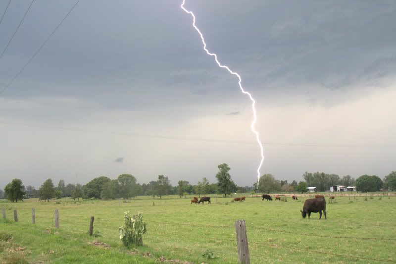
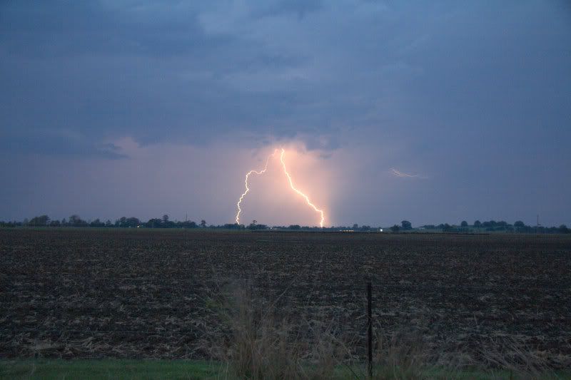
We let this storm retreat to the south and headed back into Grafton to see what else was developing. As luck would have a nice lightning active cell was approaching so found a spot and set up with the hope of catching some late arvo CGs. We got pretty lucky and I managed to bag a few nice ones. There was also a very nice rain free base that persisted for a while.


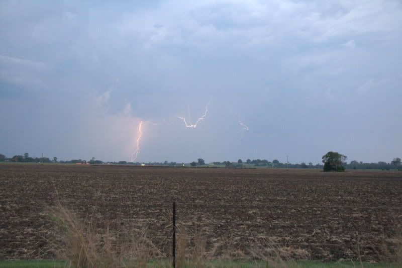
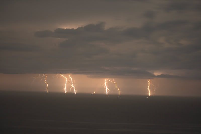
Rain finally forced to pack up our gear and after a quick radar check we decided to venture back north in the hope of grabbing some more action. Unfortunately nothing was happening around the area further north with most activity that was approaching from the west dying out. We stopped at Casino and had a final radar check and noticed there was some lightning active cells still to the south, although offshore. So off we went to try and bag some more lightning pics but it was all pretty distant and we weren't really prepared to do another long drive. So we stopped at a vantage point near Woodburn and got some shots there but the temptation was too much and we ventured into Evans Head to watch a nice, but very distant offshore CG fest.


Our images were beginning to come about a bit dodgy despite shooting at f/1.8 so we called it a night.
Well what can I say it was a very satisfying day, managed to bag some quite nice action and the Fozzie managed to get her very first hailstorm since I got her in 12mths ago. It was a real pleasure to get out with MB again after what seems like an eternity and talk to him about all things storm related. Sorry about the long winded nature of the report but wanted to make sure I got all the details right and show the best of my pics. Till next time,

Cheers

Jason


South Lismore, Northern Rivers NSW.....Supercells are us!!

Offline Jimmy Deguara

  • Australian and Tornado Alley storm chaser
  • Administrator
  • Wedge tornado F5
  • *
  • Posts: 2,218
  • Gender: Male
  • Storm Chaser since 1993, Tornado Alley 2001
    • Australia Severe Weather
Re: NSW/QLD Showers/rain/storms 28th Nov - 4th Dec 2009
« Reply #12 on: 30 November 2009, 06:12:38 AM »
That is a very nice supercell - nice structure and organisation. Saw it on the radar and at at least two scans from memory had v-notch signatures. Would have been a nice storm to chase too! I certainly did not forecast the region to have that sort of action!

Regards,

Jimmy Deguara
-------------------------------------
Australian Severe Weather
www.australiasevereweather.com

Australian Thunderbolt Tours
www.thunderbolttours.com

Phone  0408 020468  (International :  61  2  408 020468)

Offline Michael Bath

  • storm chaser
  • Administrator
  • Wedge tornado F5
  • *
  • Posts: 1,602
  • Gender: Male
    • Australian Severe Weather
Re: NSW/QLD Showers/rain/storms 28th Nov - 4th Dec 2009
« Reply #13 on: 30 November 2009, 06:24:50 AM »
Hi all,

A few photos follow to compliment the ones Jason Paterson has posted for our chase to the Grafton area yesterday (28th Nov).

The moisture profile was not the best over the northern parts of the Northern Rivers after the altocumulus band with isolated showers crept through during the morning. A comparison between Casino and Grafton reveals the DPs were a few degrees better to the south. The sky was reflecting this so we headed that way - though at first all convection looked very moisture starved.

Along the Summerland Way south of Casino. This is the first cell that took off and passed over Grafton radar, producing a microburst between Lawrence and South Gate.


Mid level funnel at Lawrence


This was the main storm of the day - it crept close to Grafton but only hailed at South Grafton. However the outflow winds were impressive well north of the core. We later saw a tree across a suburban street in the northern part of town.


These at Elland (a couple of ks S of South Grafton). The tree had brought power lines down across the road. Maximum hailstone size would have been about 3.5cm.


The next storm gathered west of Grafton again - third in the same location really.  It spat out a LOT of CGs.


The rain hit so we headed north then back east to pursue the evening lightning, but it was mostly distant.


All my pics for the day are here.

Thanks for Jason for the driving. Captain Supercell only made once brief appearance early on in the day - storms got going after that!

MB


Location: Mcleans Ridges, NSW Northern Rivers
Australian Severe Weather:   http://australiasevereweather.com/
Lightning Photography:   http://www.lightningphotography.com/
Early Warning Network: http://www.ewn.com.au
Contact: Michael Bath

Offline Shaun Galman

  • Stove pipe F3
  • *
  • Posts: 441
  • Gender: Male
    • ridgelightning.com
Re: NSW/QLD Showers/rain/storms 28th Nov - 4th Dec 2009
« Reply #14 on: 30 November 2009, 08:05:37 AM »
Hi guys,

Some great photos MB and Pato! Nice work  ;D

Good to see a bit of SC action (however brief it may have been) the structure in and around that wall cloud looks amazing!

It's been a fairly mild/poor start to the season so far. I'm praying something fires out here soon before I have to pack up and leave the Ridge for good. I'll be moving to Albury so at least I'll have the chance of seeing/chasing a decent SC at some stage!   

Nothing promising on the outlook for my area so far. Been very quiet out here storm wise to say the least.

I think I will add a decent electrical storm to my xmas wish list lol!  ;)

Kindest regards,
Shauno
Chasing Region: Lightning Ridge. N.S.W.
Website: www.ridgelightning.com