Author Topic: NSW / S QLD Storms 2-5 October 2009  (Read 19370 times)

0 Members and 2 Guests are viewing this topic.

Offline Antonio (stormboy)

  • Stove pipe F3
  • *
  • Posts: 481
  • Gender: Male
Re: NSW / S QLD Storms 2-5 October 2009
« Reply #15 on: 06 October 2009, 09:27:18 AM »
It is now thundering and the storm is just around the corner (Parramatta) it looks so black and on the terry hills radar it sure is red! Looks like jimmy was right.

stormboy

Offline Harley Pearman

  • Barrel tornado F4
  • *
  • Posts: 584
Re: NSW / S QLD Storms 2-5 October 2009
« Reply #16 on: 06 October 2009, 12:12:12 PM »
Western Sydney thunderstorm 5/10/2009

An intense thunderstorm has passed over Blacktown late afternoon of 5 October 2009 producing some significant cloud to ground lightning strikes. Given the amount of lightning I would not be surprised if power blackouts have occurred in some suburbs. The storm brought a burst of intense rain including a short period of strong wind which eased off rapidly once the main core of the thunderstorm had passed.

There are still some showers and storms passing across Sydney so rainfall totals will change but up until 5 pm 5/10/09 rainfall across Western Sydney from the event had varied from 1.8 mm to 22 mm with North Rocks receiving the highest total.

I took these lightning shots near Blacktown Hospital near where I live.

Harley Pearman

Offline Richary

  • Barrel tornado F4
  • *
  • Posts: 680
  • Gender: Male
Re: NSW / S QLD Storms 2-5 October 2009
« Reply #17 on: 06 October 2009, 12:57:26 PM »
I was out towards the airport this afternoon and saw it looking nice and black to my west and southwest, with quite a few ground strikes happening as well. As I drove home the rain wasn't that heavy except for a brief period on the M4 near Homebush Bay with the traffic backing off to about 60. Some quite nice flashes and another line is heading this way through Camden at the moment, be interested to see if it keeps going long enough to get here.

On the Grafton radar this afternoon there was a particularly nasty looking cell inland from Wooli, and someone rang the ABC to say there had been large hail at Ulmarra a bit north of Grafton. His description included hail from basketball size down to cricket ball, but I think we will take that one with a grain of salt :-)

Also reports of heavy hail looking like snow down near Dapto as well.

EDIT: Camden cell has just developed a nice black core, current track would take it a bit west of me, Jimmy might be in a good spot. Hasn't been severe warned yet though.
« Last Edit: 06 October 2009, 01:10:07 PM by Richary »

Offline Jimmy Deguara

  • Australian and Tornado Alley storm chaser
  • Administrator
  • Wedge tornado F5
  • *
  • Posts: 2,218
  • Gender: Male
  • Storm Chaser since 1993, Tornado Alley 2001
    • Australia Severe Weather
Re: NSW / S QLD Storms 2-5 October 2009
« Reply #18 on: 06 October 2009, 02:22:52 PM »
Went for a little chase around the place - was unable to get much in the way of lightning video though did score tiny hailstones and very heavy rain near Schofields - Rouse Hill. Some pictures below:


Regards,

Jimmy Deguara
-------------------------------------
Australian Severe Weather
www.australiasevereweather.com

Australian Thunderbolt Tours
www.thunderbolttours.com

Phone  0408 020468  (International :  61  2  408 020468)

Offline pingtang

  • Multi-vortex F1
  • *
  • Posts: 70
  • Gender: Male
    • Southcoastweather
Re: NSW / S QLD Storms 2-5 October 2009
« Reply #19 on: 06 October 2009, 04:37:18 PM »
Lightning barrage- Nowra area

We witnessed an extremely lightning active storm near  Nowra today. Overall the structure was nothing to write home about, but we did have a nice dark base which remained rain free for a short while. When the RFB dropped its load, a barrage of CGs touched down ahead of the precip curtain. I was gobsmacked at the quality of these CGs, thick staccatos, sometimes 3-4 in a single discharge. Alot of these CGs touched down in the vicinity of my parents place. My dad reported atleast half a dozen flangs,some hitting within a few hundred metres with shotgun thunder.

Heres a short video clip showing many of these CGs. Well worth watching!!

lightning barrage

Offline DanTheMan

  • Rope Tornado F0
  • *
  • Posts: 18
  • Gender: Male
Re: NSW / S QLD Storms 2-5 October 2009
« Reply #20 on: 06 October 2009, 04:55:42 PM »
Dan, I think you take the sad face off soon, as you said not until next week, so running through the synoptics, GFS storm cast and capes, and it is looking not bad for Wednesday storms up here. Could be early afternoon too. BOM have issued possible storms/ showers as well for Wednesday.

Last night a few storms fired up out west QLD  around Injune and Mitchell, but due to lack of moisture they were very, very short lived and just remained in that vicinity.

Just hot, windy and dusty up here in SEQ, 34.8C at the airport at 2.16pm.

Well I can bring back the sad face again this week I think, not looking so good for this Wednesday after all! Now I'm watching next Monday, whats the bet that will change as we get closer to the day...
I'm going on strike.

Offline Jimmy Deguara

  • Australian and Tornado Alley storm chaser
  • Administrator
  • Wedge tornado F5
  • *
  • Posts: 2,218
  • Gender: Male
  • Storm Chaser since 1993, Tornado Alley 2001
    • Australia Severe Weather
Re: NSW / S QLD Storms 2-5 October 2009
« Reply #21 on: 06 October 2009, 04:56:22 PM »
Pintang,

I watched it and really enjoyed it! Good positioning too - though I would have liked to see some more of that feature towards the right. The first lightning exchange is incredible!

Coincidently, I was video editing footage from 2005 and came across a lightning barrage of a similar nature (though I missed some of the footage due to the video camera on pause!) Still some nice stuff salvaged.

Regards,

Jimmy Deguara
-------------------------------------
Australian Severe Weather
www.australiasevereweather.com

Australian Thunderbolt Tours
www.thunderbolttours.com

Phone  0408 020468  (International :  61  2  408 020468)

Offline Richary

  • Barrel tornado F4
  • *
  • Posts: 680
  • Gender: Male
Re: NSW / S QLD Storms 2-5 October 2009
« Reply #22 on: 06 October 2009, 05:50:59 PM »
Some very nice shots in that video, congratulations!

Offline enak_12

  • Elephant Trunk F2
  • *
  • Posts: 153
  • Gender: Male
Re: NSW / S QLD Storms 2-5 October 2009
« Reply #23 on: 06 October 2009, 07:02:21 PM »
I just got a new car over the weekend and today seemed like a good day to give it a good drive going after some storms..Ah if only I went to Grafton like I was considering but opted for a shorter drive to Bellingen instead.

First I sat at a lookout in Coffs and watched the small cells pop up on the ranges, I coulnt see much of the cell moving up to Woolgoolga and so I thought I would check out the radar on the phone and if it looked nice I was gonna chase it but it wouldnt connect so I decided I would wait for later development to the south. Dang! if only it loaded the net I would of chased the two severe cells to the north!

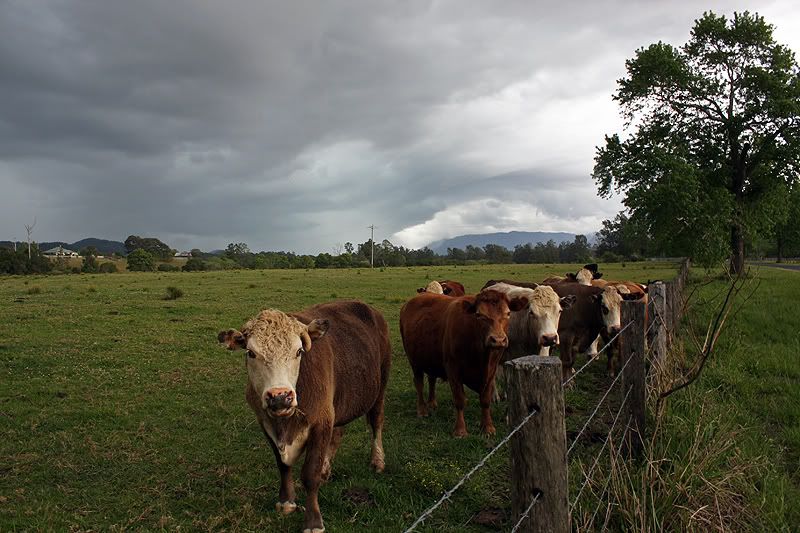
Anyway I ended up chasing the cells which poped up behind bellingen, they were pretty weak and the lightning infrequent, not much structure either:


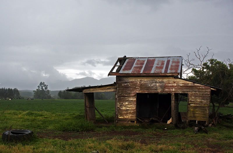
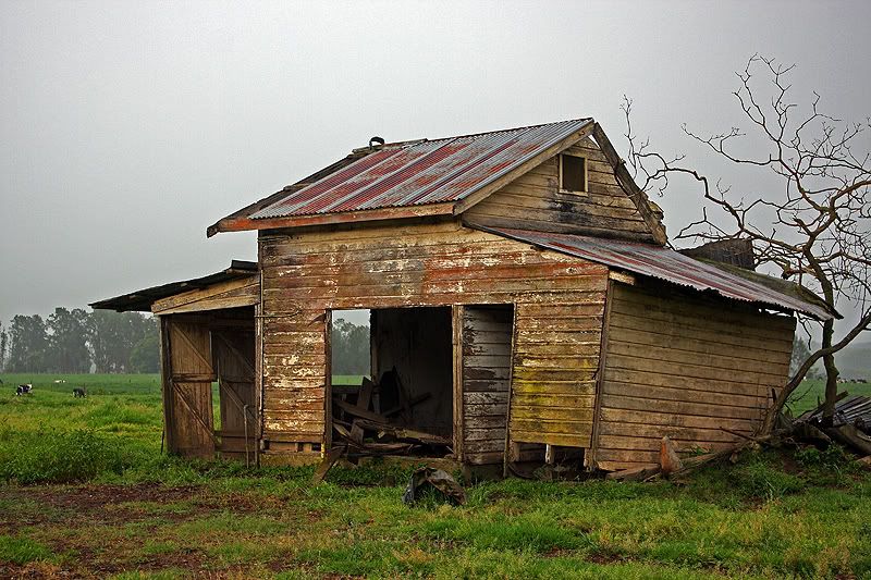
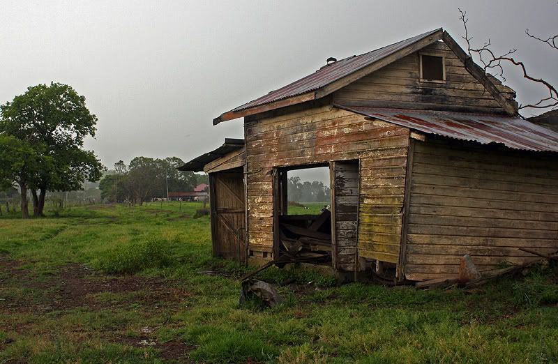
On the way back I stopped to shoot this old farm house again this time with better lighting:


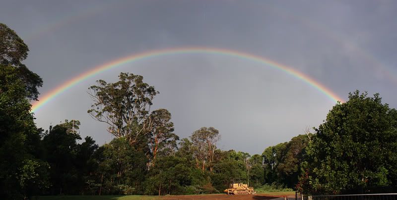
Later on I shot this nice rainbow back in Coffs:


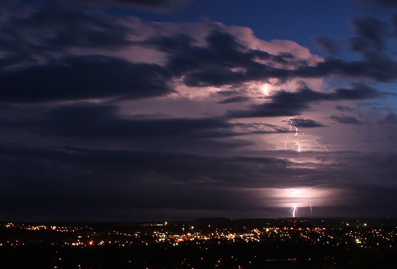
I then went back to the same lookout I started the day in to watch these nice cells develop on dark. I saw 3 of these positive strikes, only got this one on camera:


Offline nmoir

  • Elephant Trunk F2
  • *
  • Posts: 200
  • Gender: Male
  • "busting chases since 1999"
    • Oculi.com.au
Re: NSW / S QLD Storms 2-5 October 2009
« Reply #24 on: 07 October 2009, 06:30:18 AM »
nice barrage pingtang . was watching that cell on radar and it was doing well for a while there , had a northly move on it , seemed to be riding the ranges
Nick Moir
Photographer
The Sydney Morning Herald
and www.oculi.com.au

Offline Mike

  • Australian Severe Weather Moderators
  • Wedge tornado F5
  • *
  • Posts: 1,348
  • Gender: Male
  • Dry season here...boring!
    • http://StormscapesDarwin.com
Re: NSW / S QLD Storms 2-5 October 2009
« Reply #25 on: 07 October 2009, 07:04:22 AM »
Holy cow...what a brilliant display and I'm still grinning from ear to ear!  Talk about positioning yourself in the prime spot, I'm very impressed and no doubt you were at the time thanks for sharing it, it's just awesome.
Darwin, Northern Territory.
StormscapesDarwin.com
Lightning Research 2010/14

Offline DanTheMan

  • Rope Tornado F0
  • *
  • Posts: 18
  • Gender: Male
Re: NSW / S QLD Storms 2-5 October 2009
« Reply #26 on: 07 October 2009, 10:01:13 AM »
Ok ignore my last comment, looks better for us tomorrow than I 1st thought. Hopefully I'll be posting some pics here tomorrow night!
« Last Edit: 07 October 2009, 10:16:38 AM by DanTheMan »

Offline pingtang

  • Multi-vortex F1
  • *
  • Posts: 70
  • Gender: Male
    • Southcoastweather
Re: NSW / S QLD Storms 2-5 October 2009
« Reply #27 on: 07 October 2009, 01:16:32 PM »
Hello Jimmy.
 
After going through yesterdays footage  I'm quite convinced it was 7 bolts, not 6, all within 5frames of video.

Frame 1


Frame 2- The first bolt on the right continues. The second CG is a thick staccato


Frame 3- Bolts 3 and 4 now become evident


Frame 4- Bolt number 5, touches down very close to the 4th bolt but i'm conviced this is a separate CG.


Frame 5- Bolts 6 and 7!


P.S thanks for the comments everyone. Cheers.


« Last Edit: 07 October 2009, 02:03:47 PM by pingtang »

Offline Harley Pearman

  • Barrel tornado F4
  • *
  • Posts: 584
Re: NSW / S QLD Storms 2-5 October 2009
« Reply #28 on: 07 October 2009, 02:10:21 PM »
Western Sydney thunderstorm 5/10/2009

The thunderstorms that struck Sydney 5/10/2009 brought up to 32 mm of rain at Northrocks as well as 16 to 18 mm of rain around Blacktown with much lighter falls closer to Sydney city.

Additionally, the GPATS lightning tracker indicated that Sydney was peppered with 1,538 lightning strikes and flashes with some 10,645 strikes and flashes across New South Wales for 5/10/09 between 2 am and 2 am 5/10/09 to 6/10/09. Around Sydney the greatest concentration of strikes and flashes occurred over North West Sydney including Blacktown, Baulkham Hills and Hornsby with another concentration around the Liverpool / Fairfield area. The event caused power blackouts to 40,000 homes across Hornsby as well as other outages around Western Sydney suburbs.

Further to my photos of lightning, I also provide two additional photos of the approaching thunderstorm cell looking west just prior to the event taken near Blacktown Hospital.

Harley Pearman

Offline Jason(pato)

  • Elephant Trunk F2
  • *
  • Posts: 136
  • Gender: Male
Re: NSW / S QLD Storms 2-5 October 2009
« Reply #29 on: 07 October 2009, 02:26:41 PM »
Very nice stuff there Mr. Keane!! A bit of lightning retina burnage for sure. Unfortunately my part of the NRs has missed out on any decent storms so far this year. Went out to Rods house last night in anticipation of grabbing some lightning shots from the cells marching up from down south. When I arrived there was some flashing evident (mostly CC) and one cracker of a stacatto. So Rod and I set up our gear and tried our hand, ridiculously as soon as we got set up all lightning activity ceased. Got some pics of the structure en route to Rods but unfortunately no lightning from later at his place. Will be watching tomorrow evening for some offshore activity.

Storm that earlier dropped 20c piece sized hail on Grafton


Interesting lenticular formations within the storm


Pic of storm approaching from the SW which unfortunately ceased lightning activity


Cheers Jason
South Lismore, Northern Rivers NSW.....Supercells are us!!