Author Topic: Eastern NSW Storms including Canberra severe hailstorm - 24 Feb - 1 Mar 2007  (Read 57315 times)

0 Members and 1 Guest are viewing this topic.

Offline Ben

  • Multi-vortex F1
  • *
  • Posts: 34
  • Gender: Male
Fanastic photos Pingtang and great clip there Dave!!! I chased with Phil on Saturday to W Sydney, then to Lithgow and back again and encountered hail up to 2-2.5cm, strong winds up to 80km/h or so, flash flooding/heavy rain and a LOT of lightning. We probably experienced around 80 flangs for the entire day, it was crazy! Anyway here are the photos.
Cell at Penrith:
       
Inflow feature? (cell to the S of Bilpin one before they collided) Would like some opinions on this!
       
Updraft on Bilpin storm
       
Greeny/orange guster at Lithgow
       
Pan of the guster before it hit
       
Green guster overhead before it hailed
       

Offline Jimmy Deguara

  • Australian and Tornado Alley storm chaser
  • Administrator
  • Wedge tornado F5
  • *
  • Posts: 2,218
  • Gender: Male
  • Storm Chaser since 1993, Tornado Alley 2001
    • Australia Severe Weather
Hi Ben,

I have a picture with interesting structure and also met Jeff today and saw an interesting region on the northern side of that southern storm.

I have not seen radar yet.

Regards,

Jimmy Deguara
-------------------------------------
Australian Severe Weather
www.australiasevereweather.com

Australian Thunderbolt Tours
www.thunderbolttours.com

Phone  0408 020468  (International :  61  2  408 020468)

Offline David C

  • Global Moderator
  • Barrel tornado F4
  • *
  • Posts: 643
  • Gender: Male
    • Thunderbolt Tours Storm Chasing Adventures
Very nice photos Ben -- definitely storms on Saturday produced a real lot of CG lightning.
I have extended the dates of this thread since there were some storms today and will be tomorrow.

As for tonight, there was an interesting cell which tracked over the southern highlands this evening. Paul gave me a call and indicated that it was looking quite nice on Sydney radar and was also tracking ENE. Found a street in the area that gave a reasonable view and shot of bit of video just in case (100km away I should emphasize!!).

Had an overshoot that persisted during the most intense phase around 7:40 to 8:00pm. Gradually weakened and produced some ok anvil lightning and some remarkable cloud-to-air bolts. Not much exciting video but have attached some stills since I cant ftp from here).
Storm Chaser,
Thunderbolt Tours - USA & Australia Storm Chase Tours
www.thunderbolttours.com

Offline David C

  • Global Moderator
  • Barrel tornado F4
  • *
  • Posts: 643
  • Gender: Male
    • Thunderbolt Tours Storm Chasing Adventures
You can see (vaguely) in the last two shots the lightning shooting out towards the flanking line. Hope someone was taking pics as there really were some nice CA bolts.
Storm Chaser,
Thunderbolt Tours - USA & Australia Storm Chase Tours
www.thunderbolttours.com

Offline Ben

  • Multi-vortex F1
  • *
  • Posts: 34
  • Gender: Male
Thanks for the comments David.. Look forward to yours Jimmy.

Yeah I saw that Bowral cell from here this evening, looked spectacular with the overshoot, flanking line later in it's life and the anvil extending a long way to the SE. I was hope for a CA to spit out but after watching a while and getting eaten my mossies I decided to duck in and get some dinner. Got a few shots of the storm but I think your photos cover it David. Missed any CA's whilst the shutter was open, only saw CA lightning, but sure made a spectacular sight with a colourful sunset here this evening too.

Offline Michael Bath

  • storm chaser
  • Administrator
  • Wedge tornado F5
  • *
  • Posts: 1,602
  • Gender: Male
    • Australian Severe Weather
Canberra copped a dump of hail last night. These pics sent by my brother and taken by someone at his work


And this morning:


Location: Mcleans Ridges, NSW Northern Rivers
Australian Severe Weather:   http://australiasevereweather.com/
Lightning Photography:   http://www.lightningphotography.com/
Early Warning Network: http://www.ewn.com.au
Contact: Michael Bath

Offline scottme

  • Multi-vortex F1
  • *
  • Posts: 37
  • Gender: Male
Looks like it's going to be a busy day - the first sounding for Sydney looks rather unstable.

Offline Jimmy Deguara

  • Australian and Tornado Alley storm chaser
  • Administrator
  • Wedge tornado F5
  • *
  • Posts: 2,218
  • Gender: Male
  • Storm Chaser since 1993, Tornado Alley 2001
    • Australia Severe Weather
Hi all,

Impressive hail event - I followed it last night on radar. It began as a cluster of cells west of canberra. One cell then developed rapidly similar to the cell west of Bowral during the evening. But this one was larger. Both storms though seem to change direction as they intensified. Both were not long lived but obviously Canberra copped it!

Regards,

Jimmy Deguara
-------------------------------------
Australian Severe Weather
www.australiasevereweather.com

Australian Thunderbolt Tours
www.thunderbolttours.com

Phone  0408 020468  (International :  61  2  408 020468)

Jeff Brislane

  • Guest
Another round of storms again today! This time it's a nice change to see them actually come into sydney. I was out ealier and chased a little right moving cell that came off the Blue Mountains. I core punched it at Silverdale in the hope of hail but was eluded again allthough it was very intense under the core. Unknown to me though it was interacting with a severe cell near Campbelltown and by the time I got out of the precip near Camden I could see that the stronger cell further east was really going off. I was too late to catch it as it was moving at at least 70 km/h so I stopped near Narrellan. However after seeing the radar now I wish i was a little quicker and went a little further as it looks like it's dumped hail near Campbelltown.

Jeff.

Jeff Brislane

  • Guest
Here is some images of last saturdays storm near Penrith.


The northern cell finally takes off.


The two cells together a bit later on.


Southern cell goes through a brief intensification.


This was taken near the northern cells peak.


The cell as it became outflow dominant. Note the large rainfoot extending south of the outflow.


This was taken just before we core punched it.


Jeff.
« Last Edit: 01 March 2007, 12:29:57 PM by Jeff Brislane »

Offline Mike

  • Australian Severe Weather Moderators
  • Wedge tornado F5
  • *
  • Posts: 1,348
  • Gender: Male
  • Dry season here...boring!
    • http://StormscapesDarwin.com
I was doing a defence trial today when the prosecutor brought in his laptop and showed us some pics he was sent by his brother in Canberra - pretty awesome stuff, looks like snow!  You've got some more storms coming into NSW over the next day or two also no?

Mike
Darwin, Northern Territory.
StormscapesDarwin.com
Lightning Research 2010/14

Offline Dave Nelson

  • Elephant Trunk F2
  • *
  • Posts: 172
  • Gender: Male
    • Stormy Sydney
Hi all,

   ohhhh another wonderful day !

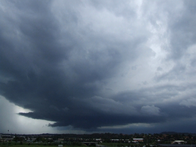
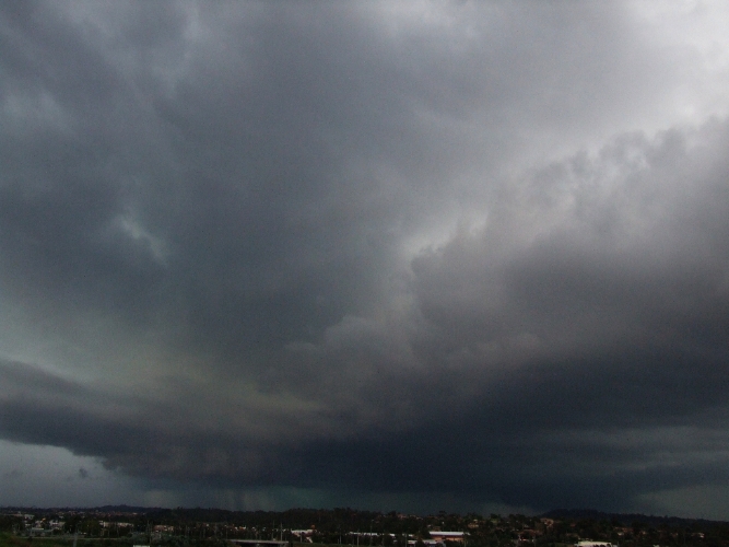
   work took me to Minto-Campbelltown area around 1330hrs. After the 2 jobs, ~ 1430hrs,  I could see that cells
were growing and that one large one was coming down off the mountains from the Katoomba area. I was moving out across the basin to the nth of Campbelltown region.  The growing cell that took my interest was out over the Camden area and was starting to look really mean.  Today I saw some of the most intense greening
in a storm that I have ever seen.

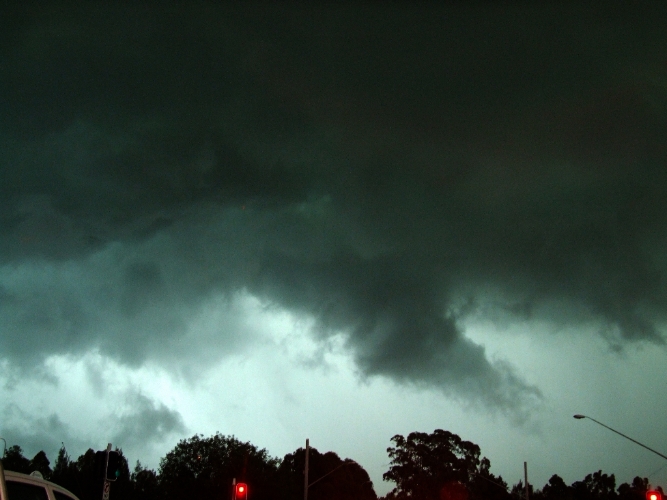
  here's a few pic's, first 3 taken looking west from between Minto and C'town  the last one from within C'town
just minutes before all hell let loose.

the storm produced many excellent CG's, with one unfortunate man being struck (he's in C'town hospital
recovering)


cheers
Dave N


Mario Orazem

  • Guest
ok here is that pic from todays storm over northern beaches taken from arncliffe 
« Last Edit: 01 March 2007, 03:20:37 PM by Mario Orazem »

Offline Mike

  • Australian Severe Weather Moderators
  • Wedge tornado F5
  • *
  • Posts: 1,348
  • Gender: Male
  • Dry season here...boring!
    • http://StormscapesDarwin.com
AWESOME!  Fantastic photos - what a monster!  Any damage from the storm?  How long did they last? 

Mike
Darwin, Northern Territory.
StormscapesDarwin.com
Lightning Research 2010/14

Mario Orazem

  • Guest
lasted about an hour....  i heard there was flash flooding on the nth beaches....  wasn't a supercell but still a good one :)