Author Topic: Eastern NSW / SE QLD Storms 10th - 12th Feb 2007  (Read 43199 times)

0 Members and 1 Guest are viewing this topic.

Jeff Brislane

  • Guest
Eastern NSW / SE QLD Storms 10th - 12th Feb 2007
« on: 10 February 2007, 08:56:23 AM »
I'm sick of waiting for someone else to start a thread for tomorrow! First analisys from last nights 12z data shows a reasonable setup for storms to occur along the Ranges from the Snowy north to the Upper Hunter and maybe the lower Mid North Coast. Instability is nothing spectacular like the other day but it's still good enough for storms to possibly reach severe levels, ie 2cm hail or 100km/h wind gusts. There is the presence of a weak upper trough which might spice things up a bit.

A few problems are an oversaturated atmosphere aloft, weak wind shear and un-impressive lapse rates but if you can get over these hurdles you will still see some enjoyable storms. Anyway i'm still waiting for 00z data to see if things have improved or weakened.

Jeff.

Offline Mike

  • Australian Severe Weather Moderators
  • Wedge tornado F5
  • *
  • Posts: 1,348
  • Gender: Male
  • Dry season here...boring!
    • http://StormscapesDarwin.com
RE: Eastern NSW / SE QLD Storms 10th - 12th Feb 2007
« Reply #1 on: 10 February 2007, 11:13:31 AM »
Im sick of not knowing how to read skew-T charts properly and LI wind flow charts properly so I can at least have an idea of what is to come tomorrow as well, even though i'm not in NSW!  With LIs of -6.23 and CAPE of 2850, CIN 42 CAP 2.34 and LFC 781 surely must mean storms!

Mike >:{

(P.S - Thanks 'delete' Dave!)
Darwin, Northern Territory.
StormscapesDarwin.com
Lightning Research 2010/14

Offline David C

  • Global Moderator
  • Barrel tornado F4
  • *
  • Posts: 643
  • Gender: Male
    • Thunderbolt Tours Storm Chasing Adventures
RE: Eastern NSW / SE QLD Storms 10th - 12th Feb 2007
« Reply #2 on: 10 February 2007, 11:40:11 AM »

(P.S - Thanks 'delete' Dave!)


I almost did it again!!

Yes this morning's Darwin sounding looks nice, should be something up there!
The big problem in Australia is that the stations are so few and far between, hence many people don't bother with Skew-Ts, or use them to see if the models have a handle on mid- and upper- levels, or use only the skew-ts generated by a model. In Sydney, for eg, what use is the morning sounding, from near the coast, if you have an approaching upper trough and destabilisation occuring. Things change and the conditions on the sounding might better reflect what is happening 200km offshore. The afternoon sounding well, things are often already happening so it might be too late.

As far as reading skew t's, there are some good articles around...Paul prepared a really nice web page on soundings ......do you still have that Paul.....it was many years ago? If not, start a thread, post a sounding and we'll see what everyone has to say.

Tomorrow looks ok for the ranges around here.  OOz had downgraded a little but that 1c cooling at h5 corresponds with maximum heating  ;D
Storm Chaser,
Thunderbolt Tours - USA & Australia Storm Chase Tours
www.thunderbolttours.com

Offline Mike

  • Australian Severe Weather Moderators
  • Wedge tornado F5
  • *
  • Posts: 1,348
  • Gender: Male
  • Dry season here...boring!
    • http://StormscapesDarwin.com
RE: Eastern NSW / SE QLD Storms 10th - 12th Feb 2007
« Reply #3 on: 10 February 2007, 11:45:38 AM »
Yep, thanks.  I won't go into skew-t's too much in this topic, JD will kill me as I have a bad habit of posting stuff in the wrong place.  I do have a skew-t topic elswhere on the forum, so maybe you could go there and have a crack - i'm waiting for answers!  I've lots of info on skew-t's - it's deciphering LI's that i'm after - anyway enough said.

hope the atmosphere unstable in NSW!

Darwin, Northern Territory.
StormscapesDarwin.com
Lightning Research 2010/14

Paul Graham

  • Guest
RE: Eastern NSW / SE QLD Storms 10th - 12th Feb 2007
« Reply #4 on: 11 February 2007, 04:00:48 AM »
Hi Dave, I'm not sure whether you were referring to this Paul  ;D, but it's been a while since I've had any of my own work online.  I can recommend this excellent site on understanding SkewT's (and meteorology in general).  It really is tops!  Here is the link for the SkewT module: http://deved.meted.ucar.edu/mesoprim/skewt/index.htm
Cheers,
Paul

Offline David C

  • Global Moderator
  • Barrel tornado F4
  • *
  • Posts: 643
  • Gender: Male
    • Thunderbolt Tours Storm Chasing Adventures
RE: Eastern NSW / SE QLD Storms 10th - 12th Feb 2007
« Reply #5 on: 11 February 2007, 11:11:48 AM »
Definitely you Paul - you had a great webpage....gee must be 1998 or thereabouts! (ps still battling the cold that I had on Weds, so did have the energy to take advantage of a stormy Saturday on the Tablelands.

I'd say there would be a nice shelf cloud crossing the Hume Hwy south of Moss Vale right about now, going by Sydney and Canberra radars.
Storm Chaser,
Thunderbolt Tours - USA & Australia Storm Chase Tours
www.thunderbolttours.com

Jeff Brislane

  • Guest
RE: Eastern NSW / SE QLD Storms 10th - 12th Feb 2007
« Reply #6 on: 11 February 2007, 01:24:52 PM »
I've been out with Kim today and we managed to intercept a beautifull severe storm west of Mittagong. It had sustained inflow for at least 1 hour before collapsing and I believe also anti-cyclonic base rotation, wait to you see some of the pics as it was just increadible. We also watched the line of cells west of Sydney on the way home which are rumbling outside now.

Did Jimmy report the 5cm hail at Rylstone?

Jeff.

Paul Graham

  • Guest
RE: Eastern NSW / SE QLD Storms 10th - 12th Feb 2007
« Reply #7 on: 11 February 2007, 01:32:51 PM »
Very interesting rainfall situation developing.  I'd say there's a good chance of flash flooding for the South Coast.  You can see on the radar and vis satellite imagery what would be a NE/SW oriented convergence line extending from about Batemans Bay NE'wards.  This line appears to be producing very intense little cells moving SW'ly with echoes in the 5th highest reflectivity band.  These cells are merging with weakening continental storms moving in from the west. 

Offline Matthew Piper

  • Australian Severe Weather Moderators
  • Multi-vortex F1
  • *
  • Posts: 47
  • Gender: Male
RE: Eastern NSW / SE QLD Storms 10th - 12th Feb 2007
« Reply #8 on: 11 February 2007, 03:20:43 PM »
I headed out to the Lithgow area today and encountered a couple of intense storm cells around 3:30-4pm. The rain was absolutely torrential in all of them and created rivers flowing down the hills around Ben Bullen. It all drained away very quickly though as when I returned half an hour later most of it had soaked into the ground.

The best storm was at Mt Piper power station where I encountered a number of close lightning strikes and a couple of minutes of small hail of around pea size or slightly larger which I have recorded on video. I was hoping to see a lightning bolt hit the Mt Piper chimney, but it was not to be. Twice today though I saw lightning hit in my immediate vicinity with the first at Lydsdale and the second at Ben Bullen. The thunder was very loud from these strikes even with the car window wound up  :)

That storm you were on Jeff looked very mean on radar. It had purple in it for a couple of frames.
Matthew Piper

Offline vrondes

  • Multi-vortex F1
  • *
  • Posts: 77
RE: Eastern NSW / SE QLD Storms 10th - 12th Feb 2007
« Reply #9 on: 11 February 2007, 05:11:08 PM »
Jeff, If your photos from the Mittagong storm you chased today are as good as the LP supercell of February 05 , then they are worth waiting for. Looking forward to seeing them. Matt, I remember stopping in Cullen bullen during a thunderstorm last year and the intensity of the rain was torrential but the lasting impression of the storm was the booming deafening sounds of thunder after  strikes hit the hills to the west of the village. The sound reverberated around the township as well as our brains!.  Looking forward to seeing your efforts as well. Tonight we're at The Entrance where an offshore pulse storm failed to deliver a decent lightshow after a promising start. Cheers, Con.

Offline pingtang

  • Multi-vortex F1
  • *
  • Posts: 70
  • Gender: Male
    • Southcoastweather
RE: Eastern NSW / SE QLD Storms 10th - 12th Feb 2007
« Reply #10 on: 11 February 2007, 05:13:59 PM »
Good evening. Just a quick reply from me.

Me and my brother were on the Canyonleigh storm just west of  Moss Vale . We also met up with Michael Thompson once again. This storm was a slow mover,but still quite severe bringing  1-2cm hailstones,torrential rainfall, and a barrage of pulsating CGs. The flash flooding near the Exeter turnoff was quite significant with some fields covered with water,and rivers crossing the freeway.


Offline David C

  • Global Moderator
  • Barrel tornado F4
  • *
  • Posts: 643
  • Gender: Male
    • Thunderbolt Tours Storm Chasing Adventures
RE: Eastern NSW / SE QLD Storms 10th - 12th Feb 2007
« Reply #11 on: 11 February 2007, 06:53:13 PM »
Well done guys - nice photos Pingtang and look forward to yours Jeff, Matt!! Some NICE storms down there today. I was saying to Paul on the phone that I hope someone was on that nice cell southwest of Moss Vale. Was anyone down near Bungendore - Captains Flat area later on as there was some pretty intense stuff there as well...nice chase country too.

Some good steady rain here in southern Sydney atm and some thunder which has been on and off for over an hour now.
Storm Chaser,
Thunderbolt Tours - USA & Australia Storm Chase Tours
www.thunderbolttours.com

Offline Dave Nelson

  • Elephant Trunk F2
  • *
  • Posts: 172
  • Gender: Male
    • Stormy Sydney
RE: Eastern NSW / SE QLD Storms 10th - 12th Feb 2007
« Reply #12 on: 12 February 2007, 01:36:02 AM »

I'd say there would be a nice shelf cloud crossing the Hume Hwy south of Moss Vale right about now, going by Sydney and Canberra radars.


yes a very respectable shelf cloud !!!  ...  I hit it just south of the Mossvale turnoff and within a few k's had to pull over cuz the rain was so heavy, and some small hail.   Waited there for a while on the downhill slope a km or 2 before the end of the freeway.
some nice cg's but a lot of cc's hidden in the clouds. turned around and went back up via Bargo and Picton.  Many large CG's and CC's  we stopped at the rest area on top on the hills on the nth side of Picton and got under shelter to do some pics.
The rain was torrential and there was a wonderful barrage of big CG's in a field not far from us.
The storm moved to the east and we continued up nth and east via the Camden bypass, then went out on the Appin rd  to a clear area jst a couple of km's short of Appin  where we watched the storm die out as it went over the coast.

 will upload pics  soon,  cant log on to my www pages for ftp at the moment  and dont think i can post directly to here


cheers
Dave N

« Last Edit: 12 February 2007, 01:41:07 AM by Dave Nelson »

Offline Dave Nelson

  • Elephant Trunk F2
  • *
  • Posts: 172
  • Gender: Male
    • Stormy Sydney
RE: Eastern NSW / SE QLD Storms 10th - 12th Feb 2007
« Reply #13 on: 12 February 2007, 01:46:12 AM »

Hi again  :)

   woken this morning ~ 0545Hrs EDT with torrential rain  here in West Ryde,  still raining at I type but has substantially lightened up.  heard ~ 8 good rumbles of thunder between ~ 0630 and 0700hrs EDT

 and see on weather radar there is another large active cell west of Campbelltown again.
maybe head out again today ....  CAPE and Li's seem to be concentrated ~ the Newcastle and a bit nth of region.

Dave N

Offline Michael Thompson

  • Multi-vortex F1
  • *
  • Posts: 57
RE: Eastern NSW / SE QLD Storms 10th - 12th Feb 2007
« Reply #14 on: 12 February 2007, 03:47:52 AM »
Quite a fruitful days chasing.

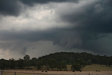
Started at Canyonleigh ( the storm that David referred to as being SW of Moss Vale ). I again had storm chaser convergence with PingTang. We watched a developing updraft for about 15 mins, it then became outflow dominated in a big hurry.

I split west only to encounter hail and torrential rain, so headed east back to the Hume Hwy just south of the Sutton Forest servo which was a battle zone with scores of cars parked under any tree that looked like offering shelter from the hail. Hail was to 2cm in size, but the odd larger bang on the roof told me there was perhaps larger. ( Hi Dave Nelson, you must have been  one of those cars ! )


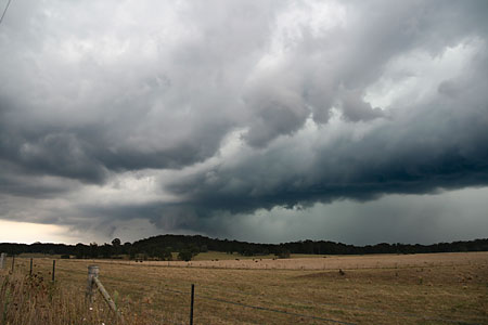
The storm weakened into a broad rain area so i headed home. I was curious to see how the now weak storm would react to the coastal moisture having already hung myself on a forecast of flash flooding type storms on another forum. I was not disappointed as it kicked up a convergence line of activity just east of the Illawarra escarprment, this was lightning active. Just as I was putting the camera on tripod a transformer was hit on the other side of the lake. I would have made a great picture, instead I got this second prize.


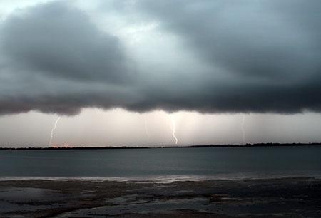
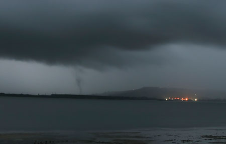
As I taking the lightning I caught this suspicious lowering out of the corner of my eye. The jury is out on this, it persisted for about 5mins. It would be easy to dismiss except the first bit to condense was on the ground ! not from cloud downwards. At no stage did the cloud tag rise upwards either.


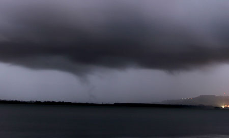
Here is the same lowering about 5 mins later and a little further southwards along the convergence line, again it is all the way to ground - guess where I will be looking tomorrow morning !


I also have video that I have not reviewed yet, but it was near total dark so the video may be useless.

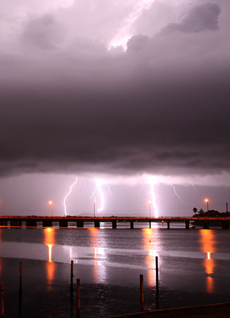
Lastly I headed east as it started to rain and took this picture from a picnic shed at Windang Bridge,


We had thunder on and off until around 4am here. I live 1 km from the ocean and therefore missed the heavier rain. I went for a 3am drive westwards ( only a storm chaser can do a 3am run ) and the rain was much heavier near the escarpment with flash flooding of creeks near Macquarie Pass.