Author Topic: NE NSW / SE QLD Storms 14-16 Dec 2006  (Read 47329 times)

0 Members and 1 Guest are viewing this topic.

Julie

  • Guest
Re: NE NSW / SE QLD Storms 14-16 Dec 2006
« Reply #15 on: 22 December 2006, 11:16:23 AM »
An interesting story in todays Central North Burnett Times regarding a storm at O'Bil Bil, near Mundubbera on Saturday.  I've had a look at the radar archives & I don't see anything to support a possible tornado BUT, in saying that, Kanigan radar does badly underestimate out that far.  Looking at the Gladstone radar & taking both into account it does support the severity at the time.
I had a chat with Troy Voss about the possible tornado & I'm tending to agree that it was.  The damage at the Augustines property happened about the time of his sighting & it was heading towards their property.


Offline David C

  • Global Moderator
  • Barrel tornado F4
  • *
  • Posts: 643
  • Gender: Male
    • Thunderbolt Tours Storm Chasing Adventures
Re: NE NSW / SE QLD Storms 14-16 Dec 2006
« Reply #16 on: 22 December 2006, 11:24:19 AM »
The storm in the pics above looks like a big HP (if we're talking about the same storm that is!). The chances of a storm like this producing a tornado more intense than the straight-line wind damage it would have produced would be remote, in my oppinion  :). Of course, storms do evolve over time and perhaps the tornado happened earlier on than when the pics above were taken. As I said, this (ie photo) stage or later..... almost no chance of a significant tornado.
Storm Chaser,
Thunderbolt Tours - USA & Australia Storm Chase Tours
www.thunderbolttours.com

Julie

  • Guest
Re: NE NSW / SE QLD Storms 14-16 Dec 2006
« Reply #17 on: 22 December 2006, 11:28:52 AM »
David, the storm in the pic was one I took here in Biggenden the same afternoon, totally different storm altogether. :)

I'm yet to find anyone with photos of that storm. 

Offline David C

  • Global Moderator
  • Barrel tornado F4
  • *
  • Posts: 643
  • Gender: Male
    • Thunderbolt Tours Storm Chasing Adventures
Re: NE NSW / SE QLD Storms 14-16 Dec 2006
« Reply #18 on: 22 December 2006, 11:29:07 AM »
Thanks Julie. After reading the newspaper article, I realised we are talking about two different events so disregard my comments above  ;D  In that case, and based on the eyewitness account, it does sound like a tornado. Any radar frames from the times in question?
Storm Chaser,
Thunderbolt Tours - USA & Australia Storm Chase Tours
www.thunderbolttours.com

Julie

  • Guest
Re: NE NSW / SE QLD Storms 14-16 Dec 2006
« Reply #19 on: 22 December 2006, 11:33:33 AM »
I'm putting them together (in between some urgent work) but hopefully have a link up tonight.
He did describe the funnel as being "a dirty greyish colour, like it had smoke & dirt mixed in".
« Last Edit: 22 December 2006, 11:35:10 AM by Julie »

Offline David C

  • Global Moderator
  • Barrel tornado F4
  • *
  • Posts: 643
  • Gender: Male
    • Thunderbolt Tours Storm Chasing Adventures
Re: NE NSW / SE QLD Storms 14-16 Dec 2006
« Reply #20 on: 22 December 2006, 11:56:13 AM »
MB Edit:  Gympie radar loop 0130z to 0900z:

http://australiasevereweather.com/storm_news/2006/radar/200612160900.gif

For people like me who are unfamiliar with the local area here (attached) is a map - O'Bil Bil Is just to the NNW of Mundubbera.
[edit: opps, map is protected, just go here and zoom out a tad http://www.zoomin.com.au/australia/qld/o%27bil+bil/ ]
Definitely a cell moves over the area around 6:00pm but does not look impressive compared to the big cells further east ie tornado unlikely to have been mesocyclonic in origin. Could have been a landspout or even a microburst kicking up dust. Whatever it was, it certainly did a bit of damage by the sounds of it.
« Last Edit: 22 December 2006, 02:01:12 PM by Michael Bath »
Storm Chaser,
Thunderbolt Tours - USA & Australia Storm Chase Tours
www.thunderbolttours.com

Julie

  • Guest
Re: NE NSW / SE QLD Storms 14-16 Dec 2006
« Reply #21 on: 22 December 2006, 12:18:57 PM »
By Troys directions & a look at my local map, he's further southeast more east of Riversleigh.  It's quite frustrating going by the Kanigan & Gladstone radars, they're just not accurate enough IMO.  As Troy said, he's looked at the radar on occasions when it's been pelting down & it only shows up as mostly white or light blue on the radar.
Yes, could well have been a landspout :)
Thanks for that David :)

MB edit - Gladstone radar 0330z to 1000z
http://australiasevereweather.com/storm_news/2006/radar/200612161000.gif
« Last Edit: 22 December 2006, 02:04:22 PM by Michael Bath »

Julie

  • Guest
Re: NE NSW / SE QLD Storms 14-16 Dec 2006
« Reply #22 on: 22 December 2006, 02:46:09 PM »
I just had a conversation with a gentlement who saw my post on WZ about this & was a witness to what Troy saw but more defined.  This man saw the Bucca tornado first hand & suffered extensive damage to his property.  Following that experience he's done extensive research of tornados even to the extent of spending several seasons in tornado alley.  He confirms a definite tornado touched down & does have photographs of it plus photos of the corkscrewing of trees & metal.  He is sending what evidence he has to the Bureau.  I've also sent him a link to this forum & hope that he posts here although he does have some issues with 'Aussie storm chasers' in general & particularly the younger ones on WZ which has discouraged him from posting there.  Jimmy, I've given him your email address & asked him to contact you as I'm sure you would be interested in it, you're a more seasoned (not saying you're old ;) ) chaser & he maybe more comfortable sharing his information with you.
« Last Edit: 22 December 2006, 02:48:30 PM by Julie »

Offline David C

  • Global Moderator
  • Barrel tornado F4
  • *
  • Posts: 643
  • Gender: Male
    • Thunderbolt Tours Storm Chasing Adventures
Re: NE NSW / SE QLD Storms 14-16 Dec 2006
« Reply #23 on: 22 December 2006, 04:16:53 PM »
That's excellent Julie!

If this fella had the inclination to post on TWZ then please encourage him to post here if he has time -- if he has been to Tornado Alley, well, there are close to a dozen on here who have too, so we look forward to his input on this event!

Not really familiar with Gympie radar but based on what you say the callibration is off and our intepretation of things based on those scan will off the mark too. There was no other convection in the way and proximity to the radar was such that attenuation should not have been an issue.

Thanks for putting the animation together Michael!
Storm Chaser,
Thunderbolt Tours - USA & Australia Storm Chase Tours
www.thunderbolttours.com

australiasevereweather

  • Guest
Re: NE NSW / SE QLD Storms 14-16 Dec 2006
« Reply #24 on: 22 December 2006, 04:49:53 PM »
Hi Jules,

Firstly thanks for your good intentions of following this observation and for the discussion in progress. Your help in providing connections with the contacts and links to extremely important information makes it all worthwhile!

The contact details are on our main part of the website.

Quote
not saying you're old


I am old no worries about that! 38 year old chaser!

Regards,

Jimmy Deguara

Julie

  • Guest
Re: NE NSW / SE QLD Storms 14-16 Dec 2006
« Reply #25 on: 22 December 2006, 05:44:20 PM »
No worries, I've enjoyed the discussions & to be honest I was writing it off as a possible microburst until my mobile rang  :)

The ball is in his court now & my posting any further info would only be secondhand & I wouldn't like to misquote him in anyway.

38!!!!!!  Goodness me, you're only a whipper snapper!!   :D  ;D

zacaroo

  • Guest
Re: NE NSW / SE QLD Storms 14-16 Dec 2006
« Reply #26 on: 05 January 2007, 06:30:11 PM »
My input.

15 December Thunderstorms
Nice storms around today but unfortunately we were missed by them.


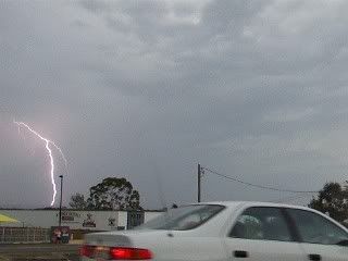
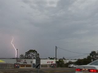
Line 1 moved north of us through the Morayfield/Caboolture area I am guessing. We rode to McDonnell Road and watched some infrequent CG's, we realized it was trcking north so we found a new position out the front of Kippa Ring School where we saw some stunning CG displays. I got a few videos and got some AWESOME stills out of the videos. We went home and my dad drove us to Scarborough to watch the lightning as the storm moved out into the bay, but when we arrived the storm had collapsed and there was no lightning. We got back at about 6.20pm and saw that a second cell had formed and was coming this way. 
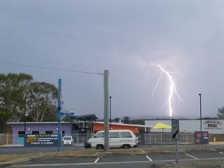
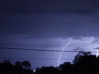
We checked the warning and the radar and decided to ride up to McDonnell Road, we got there and saw it was a really CG active cell. There was a massive guster, it was really, really big. By this time we noticed the storm was moving to the NW so we went back down to Kippa Ring School where we viewed some CG's and there was also possibly a lowering from the guster that looked like the start of a tornado, it was visible when lightning lit the sky up, it was the for around 1 minute before it wasn't there the next flash. We stayed for another couple of minutes until we headed to Corey's house to get shots from his westward facing verandah. We checked the radar and the severe thunderstorm warning and it was predicted the storm would pass to our NW. We went outside and started filming some beautiful anvil crawlers I got some good videos and even better video stills out of it. We filmed for a good hour at least. We went and checked the radar again to see it had all passed and we saw another cell had formed and was coming this way. When it got here it had collapsed into some moderate rainfall and some infrequent CC's which were accompanied by some really loud, long rumbles of thunder.

In my rain gauge we had 6.5mm of rain from this day. It was a good day to start the holidays.


16 December Thunderstorms
The day started off early with storm cells firing up around Warwick and Toowoomba and moving to the North-North East. I keenly eyed the radar for a few hours and knew we were not going to get a direct hit. The storms went through Gympie, Rainbow Beach and surrounding areas. Double Island Point - approximately 4km east of the Rainbow Beach Township, recorded wind gusts of 196km/h as the storm went through the area. This may be a malfunction of the equipment but I haven't heard anything officially. The also received 30mm of rain in 30 minutes. Here we received 2mm from a weak cell that passed through and gave us some decent rumbles and crawlers. At around 11pm a line of convergence hit here and we got another 7mm out of it overnight


Offline Michael Bath

  • storm chaser
  • Administrator
  • Wedge tornado F5
  • *
  • Posts: 1,602
  • Gender: Male
    • Australian Severe Weather
Re: NE NSW / SE QLD Storms 14-16 Dec 2006
« Reply #27 on: 06 January 2007, 01:08:16 AM »
You would have seen this on the WZ forums perhaps - but if not:

Jeff Callaghan from Severe Weather at the BoM QLD says the techs have checked the Double Island Point AWS and everything was fine so the observation stands - it is an Australian record for a thunderstorm: 196km/h (106kn)

Location: Mcleans Ridges, NSW Northern Rivers
Australian Severe Weather:   http://australiasevereweather.com/
Lightning Photography:   http://www.lightningphotography.com/
Early Warning Network: http://www.ewn.com.au
Contact: Michael Bath

zacaroo

  • Guest
Re: NE NSW / SE QLD Storms 14-16 Dec 2006
« Reply #28 on: 06 January 2007, 07:13:51 AM »
No I had not Michael. Thanks for that, I can't believe it happened and wasn't a malfunction.

zacaroo

  • Guest
Re: NE NSW / SE QLD Storms 14-16 Dec 2006
« Reply #29 on: 28 January 2007, 08:06:21 PM »


photos i took one month after the storm outside of cooroy

Can you please post the pictures in this forum please
« Last Edit: 29 January 2007, 06:32:45 AM by Jimmy Deguara »