Author Topic: Eastern NSW Storms 28 - 31 December 2006  (Read 27304 times)

0 Members and 1 Guest are viewing this topic.

Offline Michael Bath

  • storm chaser
  • Administrator
  • Wedge tornado F5
  • *
  • Posts: 1,602
  • Gender: Male
    • Australian Severe Weather
Eastern NSW Storms 28 - 31 December 2006
« on: 29 December 2006, 11:08:09 AM »
Jimmy is chasing southwest of Sydney and has just reported pea sized hail at Buxton. The cell has a few whites on tracker and is slowly heading towards the NE. No STW issued for it.

Next few days look like more widespread shower and thunderstorm activity which is good to see after the recent lull.

Michael

« Last Edit: 04 January 2007, 03:15:02 AM by Michael Bath »
Location: Mcleans Ridges, NSW Northern Rivers
Australian Severe Weather:   http://australiasevereweather.com/
Lightning Photography:   http://www.lightningphotography.com/
Early Warning Network: http://www.ewn.com.au
Contact: Michael Bath

Offline Michael Thompson

  • Multi-vortex F1
  • *
  • Posts: 57
RE: Eastern NSW Storms 28 - 31 December 2006
« Reply #1 on: 30 December 2006, 03:06:18 AM »
As often is the case I chased this same cell. It was about the only show in town ( and further afield ). At one stage it had a nice RFB and became moderately CG active. I was located at Tennessee Orchard just north of Mittagong, pictures taken looking north towards - Buxton !, Jimmy's location. 

The cell fell apart as it moved off the highlands.

Later in the afternoon signs of the approaching mid level disturbance could be seen with middle layer cloud and the benign cumulus junk further W and SW glaciating at almost winter time levels - not active in any shape or form.


The main RFB over Buxton area


Video stills of lightning


Offline Jimmy Deguara

  • Australian and Tornado Alley storm chaser
  • Administrator
  • Wedge tornado F5
  • *
  • Posts: 2,218
  • Gender: Male
  • Storm Chaser since 1993, Tornado Alley 2001
    • Australia Severe Weather
RE: Eastern NSW Storms 28 - 31 December 2006
« Reply #2 on: 30 December 2006, 03:19:49 AM »
Nice storm pictures there Michael! You and I were not far from each other - should have called! I got hail from this event with bursts of rain and hail again. Lasted a good 30 to minutes.

What astounded me though was when the storm elevated and spent of its energy, it let at least 4 dangerous cg's near the town north of Buxton! A few people took notice!

Regards,

Jimmy Deguara
-------------------------------------
Australian Severe Weather
www.australiasevereweather.com

Australian Thunderbolt Tours
www.thunderbolttours.com

Phone  0408 020468  (International :  61  2  408 020468)

Offline Michael Thompson

  • Multi-vortex F1
  • *
  • Posts: 57
RE: Eastern NSW Storms 28 - 31 December 2006
« Reply #3 on: 30 December 2006, 03:30:34 AM »
A lightning show turned on last night (28th) off the Illawarra / Sydney coasts.  It appeared that most lightning was CC, the cell strobing every  1-2 seconds, however the camera has picked up a few more CG's than was visible to the naked eye.  Junk cloud with the arrival of a weak SE wind obscured much of the action. As the weak SE worked its way up the coast some lowerings become visible under the main cell - I very much DOUBT that these anything more than harmless tags.


Click picture for larger image


Offline Jimmy Deguara

  • Australian and Tornado Alley storm chaser
  • Administrator
  • Wedge tornado F5
  • *
  • Posts: 2,218
  • Gender: Male
  • Storm Chaser since 1993, Tornado Alley 2001
    • Australia Severe Weather
RE: Eastern NSW Storms 28 - 31 December 2006
« Reply #4 on: 30 December 2006, 03:37:13 AM »
Michael,

It definitely was very active. Strobing constantly for some time. We left a little too early otherwise we would have observed it from the Bowral area or Picton. The storm developed very rapidly I may say. I have a couple of pictures indicating the distant storm as well as the weaker storm that dropped a few bolts.

Regards,

Jimmy Deguara
-------------------------------------
Australian Severe Weather
www.australiasevereweather.com

Australian Thunderbolt Tours
www.thunderbolttours.com

Phone  0408 020468  (International :  61  2  408 020468)

Offline Michael Thompson

  • Multi-vortex F1
  • *
  • Posts: 57
RE: Eastern NSW Storms 28 - 31 December 2006
« Reply #5 on: 30 December 2006, 03:39:04 AM »
Hi Jimmy - You were certainly under the very CG's I took stills of. I arrived as the cell started weakening.

Today is a different story, despite the forecasts I do prefer further west. Lithgow, Bathurst or Goulburn appeal at this stage. Having said that the sun  is breaking through here in the Illawarra.

Offline Steven

  • Global Moderator
  • Stove pipe F3
  • *
  • Posts: 410
  • Gender: Male
RE: Eastern NSW Storms 28 - 31 December 2006
« Reply #6 on: 30 December 2006, 08:55:00 AM »
Now I'm jealous!

Milan

  • Guest
RE: Eastern NSW Storms 28 - 31 December 2006
« Reply #7 on: 30 December 2006, 12:41:42 PM »
Hey Michael, Im just wondering what camera did you use to take those photo's..

Offline Jimmy Deguara

  • Australian and Tornado Alley storm chaser
  • Administrator
  • Wedge tornado F5
  • *
  • Posts: 2,218
  • Gender: Male
  • Storm Chaser since 1993, Tornado Alley 2001
    • Australia Severe Weather
Re: Eastern NSW Storms 28 - 31 December 2006
« Reply #8 on: 30 December 2006, 03:45:00 PM »
Hi all,

Storm chase 29th December 2006

Being a local storm event situation, David Croan, Nick Moir and I headed out via Richmond for a mini chase. We attempted to intercept the cell near Lithgow which seemed to indicate soem decent structure initially. Well on radar it did not look that impressive but it was certainly lightning active. The storm seemed to move in towards some inflow but after a while it seemed to become less organised.

The same cell (observed from radar) eventually interacted (collided) with another cell near Putty and intensified in one of the radar frames. Did anyone on this forum happen to head up the Putty to witness this event?

The whole line of storms rapidly collapsed by the time we got into Sydney. My location at Schofields had about 20mm of rain from the storms passing through the area! We observed heavy run-off as well on the way here.

Regards,

Jimmy Deguara
« Last Edit: 30 December 2006, 03:48:41 PM by Jimmy Deguara »
-------------------------------------
Australian Severe Weather
www.australiasevereweather.com

Australian Thunderbolt Tours
www.thunderbolttours.com

Phone  0408 020468  (International :  61  2  408 020468)

Jeff Brislane

  • Guest
Re: Eastern NSW Storms 28 - 31 December 2006
« Reply #9 on: 31 December 2006, 06:14:56 AM »
I was in Canberra yesterday arvo for lunch and afterwards observed some of the cells developing north of the city. The cell around 230pm near Goulburn looked impressive on radar with probable hail there.

I finally got away from other commitments at 4pm but was too late to intercept the strong cell that dumped hail on Queenbeyan. There was an excellent cg barrage from this storm and we witnessed one 2 second twin cg strike somewhere east of civic.

when we finally got into Queenbeyan about 30 minutes after the strongest cell went through we found some 2.5cm hailstones still on the ground and a carpet of 1cm stuff coming into town. All the flower beds along the main street were trashed!

Jeff Brislane

  • Guest
Re: Eastern NSW Storms 28 - 31 December 2006
« Reply #10 on: 01 January 2007, 04:51:11 AM »
Yesterday afternoon saw me head out for a chase around the Lithgow area.

There was a nice storm that dumped hail drifts around Yetholme on the Great Western Highway before i got out there, but it was long gone when I got to Mt Victoria. I stayed there for nearly an hour and watched a cell to the south over the Jenolan Caves area. During this time I observed an outflow boundary from the earlier cell moving south towards the newer cell I was observing.

Eventually I headed south to see if there was any hail falling from this cell around the Mt Bindoo area. I was dissapointed to find nothing but heavy rain so after a short wait I headed back towards Lithgow. When I came out of the rain I could see a new cell had developed right over the Hassans Walls area and was dumping heavy rain just west of Lithgow itself.

This turned out to be the storm of the day for me. It was producing powerfull, bright CG lightning and when I got into the core of the outflow just west of town the visability nearly dropped to zero in the heavy rain and hail and the hail was like carpet. It was so slow moving that I estimate it dumped at least 50mm to 75mm in this one area within 45 minutes to 1 hour, maybe even more. There was moderate flash flooding in this area with water flooding the highway and the railway line.

After it eased I surveyed the town for damage or flooding but it appeared that the heaviest flooding was along the highway just west of town. I noticed that lithgow topped the state obs for rainfall to 9am this morning with 33mm but the real total from where I was would have been a lot higher than that.

Jeff Brislane

  • Guest
Re: Eastern NSW Storms 28 - 31 December 2006
« Reply #11 on: 01 January 2007, 04:55:50 AM »
Today Storm forcast looks interesting out west. I've been watching the models and was a little excited yesterday but not as much now after last nights 12z gfs run. It's still looking good and there should be a few severe storms but i'm not as confident about supercells as I was.

Tomorrow is also looking a little less exciting and gfs is really throwing some weird things into the forcast like a little pocket of warmer 500hp air near my origonal target area. Plus it's not forcasting the best winds at the 700hp level.

Offline Michael Thompson

  • Multi-vortex F1
  • *
  • Posts: 57
Re: Eastern NSW Storms 28 - 31 December 2006
« Reply #12 on: 01 January 2007, 06:28:37 AM »
A couple of frustrating chase days on the 29th and 30th, Shear was dreadful - hardy any in the lower levels but enough jet level shear to spread anvil downstream, killing convection.

29th December 2006
What started as a short chase to the southern highlands saw me eventually south of Braidwood. Some great chase country in this area, although the hail pictures were taken on a dreadful forestry road. Some very isolated settlements like Hoskinstown and Rossi remind me of hillbilly country.


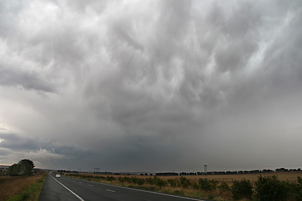
High based storm west of Goulburn


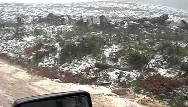
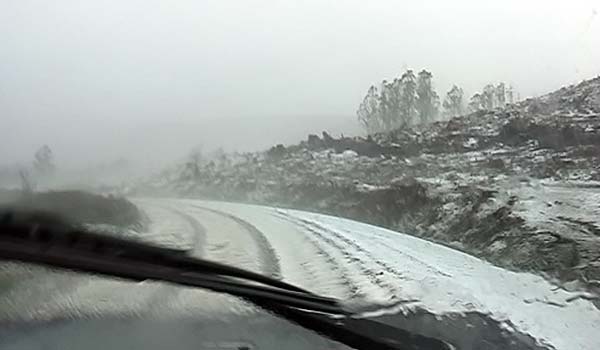
Hail covering the ground like snow south of Braidwood - video stills


30th December 2005
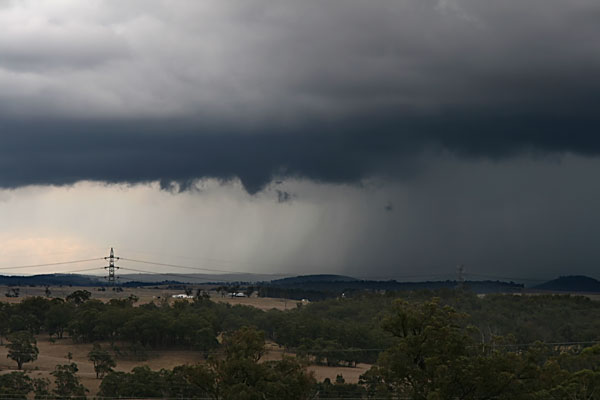
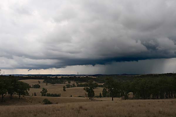
With petrol the price it is I was determined not to chase half of NSW on what was essentially a low shear day. Initial signs were not great with anvils again spreading from the storms further west over Oberon / Taralga. However I did get some development under the anvil near Canyonleigh (west of Moss Vale). For a few minutes I though that the storm would organise, but alas it fell into a heap. The scene is looking west towards Big Hill, which got 31mm.


MILAN: I took the pictures with a Canon 400D and a Sigmas 17-70mm lens. The video stills are from a Panasonic GS500, these come out quite good and provide pictures of things I can't get with the still camera. For example my reactions are not good enough for daytime lightning and teh hail shots above we taken in conditions you could not use a still camera outside.


Offline Jimmy Deguara

  • Australian and Tornado Alley storm chaser
  • Administrator
  • Wedge tornado F5
  • *
  • Posts: 2,218
  • Gender: Male
  • Storm Chaser since 1993, Tornado Alley 2001
    • Australia Severe Weather
Re: Eastern NSW Storms 28 - 31 December 2006
« Reply #13 on: 04 January 2007, 03:28:44 AM »
Hi,

31st December 2006 Too dry and storms to distant - not worth the chase in the end so I remained in Narandera. I even let go of some other activity to be in position for the subsequent storm chases in NW NSW and SW Qld.

The only consolation I had on the 30th December was hail drifts photographed near Sunny Corner east of Bathurst. There were storms but these weakened during the evening. I stayed the night in West Wyalong on the 30th and Narandera on the New Years Eve!

Check the reports of what happened in early January 2007.

NW NSW / SW QLD Storms 1st January - 3rd January 2007
http://www.australiasevereweather.com/forum/index.php?topic=273.0

Regards,

Jimmy Deguara
-------------------------------------
Australian Severe Weather
www.australiasevereweather.com

Australian Thunderbolt Tours
www.thunderbolttours.com

Phone  0408 020468  (International :  61  2  408 020468)

Offline Jimmy Deguara

  • Australian and Tornado Alley storm chaser
  • Administrator
  • Wedge tornado F5
  • *
  • Posts: 2,218
  • Gender: Male
  • Storm Chaser since 1993, Tornado Alley 2001
    • Australia Severe Weather
Re: Eastern NSW Storms 28 - 31 December 2006
« Reply #14 on: 07 January 2007, 11:38:46 AM »
Pictures from the 28th December 2006 beginning from sunrise at home:


At this stage the only storm in the state of NSW:) This storm occurred near Buxton in the southern highlands


Cell in dissipation stage - not long before this though the storm had sent 4 intense bolts of lightning and corresponing claps of thunder


Back at home only to find another storm had exploded off the coast

Small cell drops intermittent lightning


Mostly cloud to cloud lightning off the coast


Regards,

Jimmy Deguara
« Last Edit: 07 January 2007, 04:03:28 PM by Jimmy Deguara »
-------------------------------------
Australian Severe Weather
www.australiasevereweather.com

Australian Thunderbolt Tours
www.thunderbolttours.com

Phone  0408 020468  (International :  61  2  408 020468)