Author Topic: Northern NSW Storms 26 - 29 November 2006  (Read 45944 times)

0 Members and 1 Guest are viewing this topic.

Offline Steven

  • Global Moderator
  • Stove pipe F3
  • *
  • Posts: 410
  • Gender: Male
RE: Northern NSW Storms 26 - 29 November 2006
« Reply #15 on: 29 November 2006, 08:30:33 PM »
I know it's late, but woken up for a glass of water and check the news before heading to bed. However I'm asking is how come there's no more reports in the storm news section?, the latest one is from June 2006 isn't there any for this storm season? Because I really like reading those reports.

Offline Michael Bath

  • storm chaser
  • Administrator
  • Wedge tornado F5
  • *
  • Posts: 1,602
  • Gender: Male
    • Australian Severe Weather
RE: Northern NSW Storms 26 - 29 November 2006
« Reply #16 on: 30 November 2006, 01:40:32 AM »
Hi Steven,

I use Gif Animator:
http://www.ulead.com/ga/runme.htm
but there are some others you could search for at download.com or other sites.

The forum has somewhat taken over from the detailed reports on Storm News for the time being. I am working on a program to help the report writing process for Jimmy and I as it is very time consuming putting those together. But hopefully we'll do a catch up of reports soon - all the storms means things like that have to wait :)

I chased the lightning into the Clarence Valley last night with Rodney. Got some truly amazing photos with the Clarence River in the foreground. Will post some pics later this morning after I finish my morning work. Bit of a struggle after getting home at 12.50am, on top of two previous days of after midnight chases lol

regards, Michael.
Location: Mcleans Ridges, NSW Northern Rivers
Australian Severe Weather:   http://australiasevereweather.com/
Lightning Photography:   http://www.lightningphotography.com/
Early Warning Network: http://www.ewn.com.au
Contact: Michael Bath

Offline Jimmy Deguara

  • Australian and Tornado Alley storm chaser
  • Administrator
  • Wedge tornado F5
  • *
  • Posts: 2,218
  • Gender: Male
  • Storm Chaser since 1993, Tornado Alley 2001
    • Australia Severe Weather
RE: Northern NSW Storms 26 - 29 November 2006
« Reply #17 on: 30 November 2006, 01:41:17 AM »
Hi John,

Can you tell me your source of information regarding the storm that went through Newcastle having funnels and rotation? I would believe it to more a shelf cloud structure based on the situation on this day? I haven't observed radar of course.

Awesome Michael you guys got some more lightning! I headed back given I was heading through a dangerous stretch of the Pacific Highway and in very heavy rain fogged up windows and I wasn't chasing the next day. Got home 1am. Storms on the Mid North Coast weakened which I was suspecting and the new cells were way to far north.

Regards,

Jimmy Deguara
« Last Edit: 30 November 2006, 01:49:26 AM by Jimmy Deguara »
-------------------------------------
Australian Severe Weather
www.australiasevereweather.com

Australian Thunderbolt Tours
www.thunderbolttours.com

Phone  0408 020468  (International :  61  2  408 020468)

Offline nmoir

  • Elephant Trunk F2
  • *
  • Posts: 200
  • Gender: Male
  • "busting chases since 1999"
    • Oculi.com.au
RE: Northern NSW Storms 26 - 29 November 2006
« Reply #18 on: 30 November 2006, 02:13:57 AM »
wicked lightning photos and anvil crawlers , i can see a career in her future , michael.

Nick Moir
Photographer
The Sydney Morning Herald
and www.oculi.com.au

Offline Michael Bath

  • storm chaser
  • Administrator
  • Wedge tornado F5
  • *
  • Posts: 1,602
  • Gender: Male
    • Australian Severe Weather
RE: Northern NSW Storms 26 - 29 November 2006
« Reply #19 on: 30 November 2006, 03:33:52 AM »
and now for last night's storms .... !!!

Rodney Wallbridge and I headed out about 630 EDT and set up at Whiporie initially. Didn't see any lightning during the drive but saw CGs firing off as soon as we reached the Richmond Range high point on the Summerland Way.

Two cells passed by to our S-SE while in this location with cane burns offering some interesting colours.


Larger view: http://australiasevereweather.com/temp/forum/photos/2006112801.jpg


Larger view: http://australiasevereweather.com/temp/forum/photos/2006112802.jpg

We then moved to Lawrence beside the Clarence River where the main show unfolded. It certainly was one of the most amazing displays of lightning I have even seen !


Larger view: http://australiasevereweather.com/temp/forum/photos/2006112803.jpg


Larger view: http://australiasevereweather.com/temp/forum/photos/2006112804.jpg


Larger view: http://australiasevereweather.com/temp/forum/photos/2006112805.jpg


Larger view: http://australiasevereweather.com/temp/forum/photos/2006112806.jpg


Larger view: http://australiasevereweather.com/temp/forum/photos/2006112807.jpg


Larger view: http://australiasevereweather.com/temp/forum/photos/2006112808.jpg

Didn't get home till 12.50AM but certainly an incredible enjoyable evening in the Northern Rivers !

Regards, Michael

« Last Edit: 06 January 2007, 04:15:32 AM by Michael Bath »
Location: Mcleans Ridges, NSW Northern Rivers
Australian Severe Weather:   http://australiasevereweather.com/
Lightning Photography:   http://www.lightningphotography.com/
Early Warning Network: http://www.ewn.com.au
Contact: Michael Bath

Offline Michael Bath

  • storm chaser
  • Administrator
  • Wedge tornado F5
  • *
  • Posts: 1,602
  • Gender: Male
    • Australian Severe Weather
RE: Northern NSW Storms 26 - 29 November 2006
« Reply #20 on: 30 November 2006, 03:43:46 AM »
Nick - yeah - she loves taking photos though certainly not storms all that much. But it's hard not to like lightning !   She is under instruction to take photos of storms from home when I'm chasing, but doesn't need any push to go for the lightning - she loves that :)

MB
Location: Mcleans Ridges, NSW Northern Rivers
Australian Severe Weather:   http://australiasevereweather.com/
Lightning Photography:   http://www.lightningphotography.com/
Early Warning Network: http://www.ewn.com.au
Contact: Michael Bath

Offline Jimmy Deguara

  • Australian and Tornado Alley storm chaser
  • Administrator
  • Wedge tornado F5
  • *
  • Posts: 2,218
  • Gender: Male
  • Storm Chaser since 1993, Tornado Alley 2001
    • Australia Severe Weather
RE: Northern NSW Storms 26 - 29 November 2006
« Reply #21 on: 30 November 2006, 06:25:55 AM »
Hi John,

That certainly does look like a wall cloud - sorry I was too far north in Tenterfield and would not have made that particular cell. Must have interacted with the boundary.

Nice pictures.

Regards

Jimmy Deguara
-------------------------------------
Australian Severe Weather
www.australiasevereweather.com

Australian Thunderbolt Tours
www.thunderbolttours.com

Phone  0408 020468  (International :  61  2  408 020468)

Offline Jimmy Deguara

  • Australian and Tornado Alley storm chaser
  • Administrator
  • Wedge tornado F5
  • *
  • Posts: 2,218
  • Gender: Male
  • Storm Chaser since 1993, Tornado Alley 2001
    • Australia Severe Weather
RE: Northern NSW Storms 26 - 29 November 2006
« Reply #22 on: 30 November 2006, 02:20:11 PM »
Hi,

In relation to my comments on the base feature of that Newcastle cell, it certainly exhibited supercell characteristics particularly in relation to deviation. But in my chat with David Croan, I am now thinking that the storm was elevated and interactiing with the surface moisture. This quite often is the case out in areas such as Parkes, Forbes and Cowra with any organised structure becoming disorganised quickly. Was there a wall cloud existent? The storm would not have been in the phase for too long I guess after crossing the boundary I would think.

What are others' thoughts on this? Certainly a very photgenic storm pity one could not see the whole structure as that would provide more clues.

Regards,

Jimmy Deguara
« Last Edit: 30 November 2006, 04:36:01 PM by Jimmy Deguara »
-------------------------------------
Australian Severe Weather
www.australiasevereweather.com

Australian Thunderbolt Tours
www.thunderbolttours.com

Phone  0408 020468  (International :  61  2  408 020468)

Offline Steven

  • Global Moderator
  • Stove pipe F3
  • *
  • Posts: 410
  • Gender: Male
RE: Northern NSW Storms 26 - 29 November 2006
« Reply #23 on: 30 November 2006, 02:45:16 PM »
Well a big storm moved over us  :)  And mainly delivered lightning, and it was severe lightning. It didn't rain that much however the storm was very electrical and moved over at about 6:55 PM QLD time. As it was moving north my father volunteered to take me out to the water to look at the lightning, by this stage most of the activity had died off until it completely ceased but during this time we saw one big bolt but not much noise. Anyway that's my story and I'm very satisfied.  ;D ;D

Offline Jimmy Deguara

  • Australian and Tornado Alley storm chaser
  • Administrator
  • Wedge tornado F5
  • *
  • Posts: 2,218
  • Gender: Male
  • Storm Chaser since 1993, Tornado Alley 2001
    • Australia Severe Weather
RE: Northern NSW Storms 26 - 29 November 2006
« Reply #24 on: 30 November 2006, 05:51:33 PM »
Hi John,

To make my points a little clearer, I am not suggesting the storm base lowered as such - merely interacting with moisture can lower shelf clouds and scud lowerings although not sufficient for a complete lowering of the base.

It is difficult to determine given the limited pespective of the photographs supplied.

Regards,

Jimmy Deguara
-------------------------------------
Australian Severe Weather
www.australiasevereweather.com

Australian Thunderbolt Tours
www.thunderbolttours.com

Phone  0408 020468  (International :  61  2  408 020468)

Offline Michael Bath

  • storm chaser
  • Administrator
  • Wedge tornado F5
  • *
  • Posts: 1,602
  • Gender: Male
    • Australian Severe Weather
RE: Northern NSW Storms 26 - 29 November 2006
« Reply #25 on: 01 December 2006, 05:54:27 AM »
Headed off on chase about 5pm with Dave Ellem. Strong storms were evident on radar over the Northern Tablelands already and seemed like they would reach Casino sort of area just before 7pm.

Storms were also apparent developing to the north along the border somewhere with some overshoots and backshearing. Once at the spot just NW of Casino we watched the main storm spread in. Given the hot day and afternoon, high based storms were expected and certainly were occurring.


It was surprising more CGs did not occur from this storm, although there were many powerful anvil crawlers spreading overhead towards the NE.


James Harris met us and we continued to observe here till about 6.30pm. The rain and lightning was too close for comfort now so we shot north. A barrage of CGs occurred east of where we were in new development along the line - most likely where the convergence of hot humid northeasters was meeting the southerly change.

The scene was very dramatic near Kyogle with some interesting structure just to our east and the new updraft base just to the southwest.


Moving north through town we kept just ahead of the severe weather.


Microbursts spread so fast towards the north we could not keep out of it, despite heading off before it had hit our immediate location. Branches were coming off the trees and bursts of heavy swirling rain hit on and off all the way to just north of Wiangaree. So severe weather for about 15ks !

The road then heads northwest. The sunset lit view of the cell now to our northeast was very impressive.  The southerly blasted through bringing low cloud so the show was over.


Sporadic lightning continued till about 930pm but it was mainly all obscured by patchy stratocumulus.

My daughter Katrina managed to get a couple of lovely daytime CGs out the front of our home at McLeans Ridges shortly after 7pm.


Regards, Michael


« Last Edit: 01 December 2006, 08:31:35 AM by Michael Bath »
Location: Mcleans Ridges, NSW Northern Rivers
Australian Severe Weather:   http://australiasevereweather.com/
Lightning Photography:   http://www.lightningphotography.com/
Early Warning Network: http://www.ewn.com.au
Contact: Michael Bath

Offline Jimmy Deguara

  • Australian and Tornado Alley storm chaser
  • Administrator
  • Wedge tornado F5
  • *
  • Posts: 2,218
  • Gender: Male
  • Storm Chaser since 1993, Tornado Alley 2001
    • Australia Severe Weather
RE: Northern NSW Storms 26 - 29 November 2006
« Reply #26 on: 01 December 2006, 04:11:18 PM »
Hi guys,

I'll attempt to show a few pictures from the chase - namely from the 27th November 2006 supercell event. Unfortunately due to either dark lighting, precipitation, lack of opportunities, the pictures are not the best but at least they give some indication of what the storms were doing:

Storm in the distance on the 26th November 2006 - Putty Road blocked off by bushfires


Storm on the 27th November 2006 finally breaks the cap


base structure of the storm - I have to check video for this component as there was this funnel like base persisting for a little while


I was in an awkward position and I may have bumped the camera settings


Let's just say the measured hail size has to be revised to 4.6 or 4.7cm in diameter - this was once again a rush job - however I can say that considerable melting had taken place


Supercell E of Glen Innes


High based severe storms approaching S and SW of Glen Innes


Back to the supercell north of Glen Innes


Supercell approaching near Tenterfield


Regards,

Jimmy Deguara
« Last Edit: 03 December 2006, 12:30:14 AM by australiasevereweather »
-------------------------------------
Australian Severe Weather
www.australiasevereweather.com

Australian Thunderbolt Tours
www.thunderbolttours.com

Phone  0408 020468  (International :  61  2  408 020468)

Offline Michael Thompson

  • Multi-vortex F1
  • *
  • Posts: 57
RE: Northern NSW Storms 26 - 29 November 2006
« Reply #27 on: 03 December 2006, 03:38:06 AM »
Referring to the Monday 27th Northern Tablelands area the sat picture belows shows the importnace of chasing boundaries. In our case a kind of dryline, but not in the mid west sense, as the air behind the dryline was still very unstable.


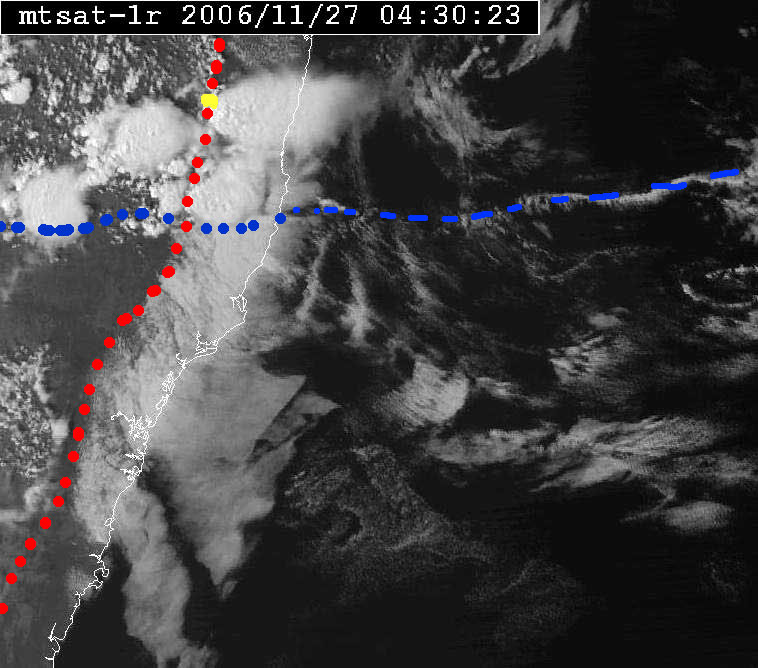
If you look at the picture you can see the coastal strato cumulus junk in a distinct band up the coast and penetrating inland a few miles. The trough was aligned very roughly east/west in the region of the storms. Note how the our storm (the top and right most on the picture) is seen clearly tapping the moisture, but it did form right on the boundary as east of the boundary had no convection, despite abundant moisture.

After tracking back to Glen Innes I lost Jimmy, but became interested in the lightning from the higher based stuff westwards. Outflow from our storm actually introduced some moisture, and after dark the whole area took off with lightning. The whole lot developed into a convective complex, but a small one.

On a side note to the lightning - a chaser was struck, the chaser wants to remain anomymous, it left several long red track marks radiating from the shoulder ( there is a picture and I hope that it gets posted one day ). The chaser was dazed for several minutes and has a very sore shoulder, but otherwise is OK. It was obviously not a direct strike. The same chaser 5 years ago in the very same town ( Glen Innes ), and not more than 500 yards away from Monday's bolt, had sparks fall all over their car as it passed under a telegraph pole that scored a direct hit. I was in the car behind.

Some pictures from Monday, the ones that are not video stills can be clicked for larger picture.

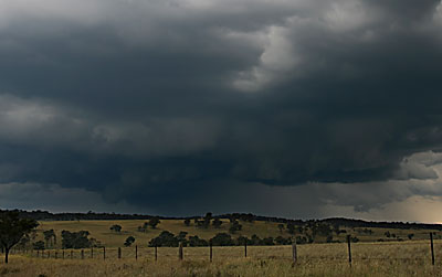
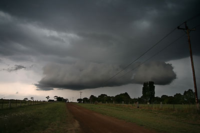
Just west of Ebor, storm is only 20 mins old at this stage.


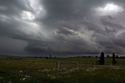
Looking back to the hail area


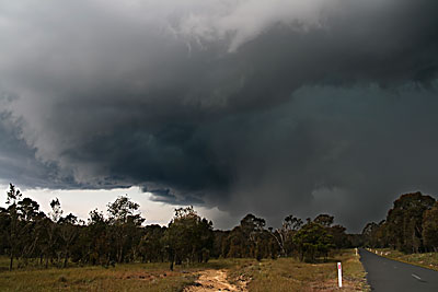
Some of the structure west of Glen Innes around sunset


The hail that was falling near Ebor - as per Jimmy's calipers in post above.(Video Still )


CG up the road whilst I was in hail core ( video still )


Well after sunset , west of Glen Innes - now that is a base ! ( video still )


__________________
Michael
http://ozthunder.com

Offline Jimmy Deguara

  • Australian and Tornado Alley storm chaser
  • Administrator
  • Wedge tornado F5
  • *
  • Posts: 2,218
  • Gender: Male
  • Storm Chaser since 1993, Tornado Alley 2001
    • Australia Severe Weather
RE: Northern NSW Storms 26 - 29 November 2006
« Reply #28 on: 03 December 2006, 04:49:38 AM »
Hi Michael,

I have a fair idea who it could be who was struck - hopefully he is ok. Ensure that a full medical check is undertaken as often the injuries of lightning occurs afterwards sometimes months down the track. Hopefully no internal damage.

Regards,

Jimmy Deguara
-------------------------------------
Australian Severe Weather
www.australiasevereweather.com

Australian Thunderbolt Tours
www.thunderbolttours.com

Phone  0408 020468  (International :  61  2  408 020468)

Offline David C

  • Global Moderator
  • Barrel tornado F4
  • *
  • Posts: 643
  • Gender: Male
    • Thunderbolt Tours Storm Chasing Adventures
RE: Northern NSW Storms 26 - 29 November 2006
« Reply #29 on: 03 December 2006, 05:50:31 PM »
What a beauty of a storm, Michael T and Jimmy -- excellent captures and photos! My day briefly.....

My intention was to chase Tuesday, simply because it was closer to Sydney and things are too busy at work to afford the time off. Anyway, after speaking to Jimmy and Paul, decided it was a must chase day. Met up with Hector at Muswellbrook and headed north. With substantial towers going up we checked data and Murrurundi and saw the left mover....oh well, Plan B. Convection a fair way to the west was lightning active although the 10C DP at Tamworth did not impress us. The stuff developing over the southern part of the Nthn Tablelands looked ok but was clearly evaporating from the base up....moisture injection was needed. So,,,,we headed to Tamworth and then on the road to Gunnedah, since the anvil was somewhat impressive. Closer inspection revealed the base was high and there was a fair bit of lightning, however there were several updrafts at play which made shooting video difficult (CGs over a wide area). Anyway - after 12 minutes enough was enough and we decided to head back hoping convection to the south would fire on the way. It did and we watched a quite impressive right mover to our north, from somewhere near Wallabadah. Clear air CGs out the back! Sadly, had to press on home. The ideal target was just a little too far.
Storm Chaser,
Thunderbolt Tours - USA & Australia Storm Chase Tours
www.thunderbolttours.com